More information available about BLM Programmatic EIS

Programmatic BLM EIS

Above: BLM map for the programmatic fuel management EIS. The cross-hatched area identifies the Project Boundary. The small dots near the names of cities identifies the locations of Scoping Meetings.

(Originally published at 1:30 p.m. MST January 11, 2017)

When the Bureau of Land Management announced on December 22 the agency was going to write two blanket Programmatic Environmental Impact Statements to streamline fuel treatment projects in much of the Western United States, the web site they referred the public to for more information had zero information. This presented a problem since the since the deadline to comment was initially February 20. After we inquired on January 2 about where interested citizens could find out what the BLM planned to do, we heard back from them today, January 11, saying they have now posted some information at the site.

BLM fuel break
BLM fuel break. BLM photo.

We checked and found the map shown at the top of this article. There is also a Notice of Intent, Bulletin, and a list of public meetings.

The agency is proposing to develop two Programmatic Environmental Impact Statements for BLM lands in the states of Idaho, Oregon, Nevada, California, Utah, and Washington. One will cover the construction of fuel breaks while the other is for fuels reduction and rangeland restoration.

Now that they have a schedule for public meetings which runs through February 15, the deadline for comments has been extended to February 28.

The blanket approval will mean that individual landscape-scale fuel breaks and fuel reduction proposals will only need minor additional environmental reviews to proceed.

Fuel breaks are intended to interrupt the continuity of vegetation making it easier to control or stop the spread of wildfires.  They can be created manually by hand crews and mechanized equipment, or through the use of herbicides. There is no guarantee of success since wind-blown burning embers can be lofted hundreds or thousands of feet ahead of a flaming front, crossing the breaks.

Pyrocumulonimbus clouds

Pyrocumulonimbus Cloud

Above: Bureau of Meteorology, Australia

(Originally published at 11:38 a.m. MST January 11, 2017)

The Australian Government’s Bureau of Meteorology has an excellent article about clouds that can form over rapidly burning vegetation fires. Pyrocumulus clouds can develop into pyrocumulonimbus that can generate lightning miles away from the fire.  Below are excerpts from the article.


What are pyrocumulonimbus clouds?

They’re a thunderstorm that forms in the smoke plume of a fire (or nuclear bomb blast, or volcanic ash cloud). In Australia they most commonly form in large and intense bushfire smoke plumes. (The official name for clouds that form this way is ‘flammagenitus‘, but they’re commonly known as pyrocumulonimbus.)

How do they form?

The intense heat from the fire causes air to rise rapidly in the smoke plume. The rising hot air is turbulent and draws in cooler air from outside the plume, which helps cool the plume as it rises. As the plume rises to higher and higher elevations the atmospheric pressure reduces, causing the plume air to expand and cool even further. If it cools enough, the moisture in the plume air will condense and forms cumulus cloud, which, because it comes from the fire plume, we call ‘pyrocumulus’. The condensation process causes latent heat to be released, which makes the cloud warmer and more buoyant and causes the cloud air to accelerate upwards. Further expansion and cooling causes more moisture to condense and the cloud air to accelerate upwards even more. In the right conditions the cloud can accelerate into the lower stratosphere before losing buoyancy. Collisions of ice particles in the very cold upper parts of these clouds cause a build-up of electrical charge, which is released by giant sparks—lightning. Having produced a thunderstorm, the cloud is now known as ‘pyrocumulonimbus’.

TBT: new wildfire terminology

For Throwback Thursday, here’s what we wrote on April 1, 2009:


On the Daily Show last night there was much lampooning of the Obama Administration’s “rebranding” of the “War on Terror” into the new term they want to use:  “Overseas Contingency Operation”.  Really. Seriously.

And taking that several steps further, John Oliver said other rebranding plans for the Administration will include:

  • Flooding in North Dakota will become: Semi-Voluntary Property Baptism
  • Obesity Epidemic will become: Enhanced Biological Jollification

And my favorite:

  • Forest Fires will become: Extreme Wildlife Oxification and Talking Bear Employment Opportunities

Oliver then did a (poor) impression in his English accent of Smokey saying:  “Only You, Kids, Can Prevent Extreme Wildlife Oxification”.

Jon Stewart:  “Obviously you didn’t have Smokey Bear in England.”

Oliver: “No, Jon, we just let our forests burn.”

Erickson receives contract to build two Aircranes for South Korea

aircrane helicopter

Above: An Erickson Aircrane reloads with retardant while fighting the Beaver Fire in northern California, August 12, 2014. Photo by Bill Gabbert.

(Originally published at 11:58 a.m. MST January 10, 2018)

Erickson Incorporated has received a contract to build two new Aircrane firefighting helicopters for the Korea Forest Service (KFS). These aircraft are in addition to a previously ordered S64E Aircrane currently under construction at Erickson and due to be delivered in the third quarter of 2018.  These two additional aircraft will be equipped with firefighting tanks, sea snorkels, foam cannons, glass cockpit, composite main rotor blades and night vision goggle capability.

In 2001 KFS became the first foreign government to purchase S-64s from Erickson. To date it has operated five Aircranes in South Korea while maintaining a contract for parts and service support.  This new contract brings the total number of orders for the KFS Aircrane fleet to eight, with the expectation of delivering the seventh and eighth aircraft by the end of 2019.

Erickson owns 20 S-64 Aircrane helicopters as part of their total fleet of 50 aircraft. The S-64 Helitanker is equipped with a 10,000 liter (2,650 gallons) tank capable of rapid snorkeling either fresh or saltwater.

Images from mud flows and flooding in Southern California

We spent a few minutes on Twitter Tuesday evening looking for information about the impacts of the very heavy rain northwest of Los Angeles over the last 24 hours. The freshly barren burned hills above some of these areas contributed to the extraordinary amount of water and debris transported into the communities.

Nominations being accepted for 2018 Aerial Firefighting Award

Aerial Firefighting Award

Nominations are now being accepted for the 2018 Aerial Firefighting Award, which recognises  a significant contribution by an individual or organization to aerial firefighting.

The Award was inaugurated in honor of the late Walt Darran and is previously known as the “Walt Darran Award”. Walt was a pioneer and advocate for advances in aerial firefighting. Being a highly experienced S2-T air tanker pilot and former highly decorated US Navy aviator from California, USA, Walt was a constant and passionate advocate for safety and improvement in the international aerial firefighting.

You can complete a nomination form at www.aerial-firefighting-award.com/

The closing date for nominations is March 2, 2018. The winner will be announced March 13 at the Aerial Firefighting North America 2018 conference in Sacramento CA, USA.

Previous winners:

  • 2014: George Petterson, USA
  • 2015: Philippe Bodino, France
  • 2016: Jim Cook, USA
  • 2017: Jacques Bonneval, France

Probability of a wildfire, by date and location

wildfire occurrence 1992-2015 map

Above: Map showing the probability of a wildfire of at least 100 acres on January 12 between 1992 and 2015.

(Originally published at 10:40 a.m. MST January 9, 2018)

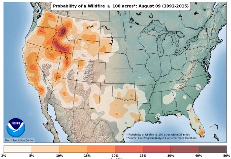
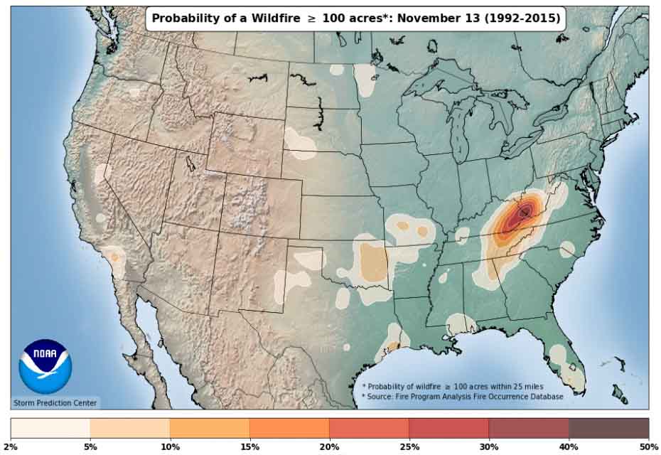
If you are searching for something to do on a cold winter day the National Weather Service has just what you need —  an interactive map system showing the probability of a wildfire of various sizes by date of the year. You can choose what size fire you’re interested in, 100, 300, 1,000, or 5,000 acres and allow the map to animate the entire year, or manually step through in three-day intervals. The data is based on wildfire occurrence between 1992 and 2015.

It is interesting seeing how activity builds and declines in specific areas like southeast Oklahoma, northern Minnesota, and the confluence of Kentucky, West Virginia, and North Carolina.

Thanks go out to Nick Nauslar of the NWS Storm Prediction Center for updating the maps.

Here are some examples:


wildfire occurrence 1992-2015 map
wildfire occurrence 1992-2015 mapwildfire occurrence 1992-2015 map

Report released on Thomas Fire Fatality

Thomas Fire fatality, map

Above: A map from the report showing the entrapment location. The red line was the firefighter’s path of travel. It leads from the black circle, which was the site of the first spot fires, to a drainage.

(Originally published at 6:25 p.m. MST January 8, 2018)

CAL FIRE has released a “Green Sheet” preliminary report for the line of duty death of CAL FIRE Fire Apparatus Engineer Cory Iverson of the CAL FIRE San Diego/San Diego County Fire Authority. Engineer Iverson was overrun by fire and killed December 14, 2017 while battling the Thomas Fire in Ventura County north of Fillmore, California.

While working with a hose lay along a dozer line he was attempting to suppress a  spot fire across the fireline. As one spot fire became multiple spot fires he attempted to escape but was not successful.

The entire 2.6MB report is here. The portion of the document that describes the entrapment is below. Fire Apparatus Engineer Iverson is “FAE1” in the report.


…FAE1 responded on the assigned tactical frequency, that he saw the spot fire. He engaged the spot fire that was on the edge of the dozer line with his hand tool.

Immediately after the report of the spot fire, a second spot fire was reported approximately 20 feet into the green.

At some point, before leaving the dozer line, FAE1 dropped a 100 foot length of hose from his hose pack on the dozer line. This action left 200 feet of hose still in his hose pack.

As FAE1 reached the second spot and began to take action, it erupted. At the same time, additional spot fires erupted along the dozer line west of the original spot fire. FF1 sprayed in the direction of the spot fires. The spot fires rapidly increased in size and the hose stream was ineffective. FAE1’s escape route back to dozer line was cut off. FAE1 began traveling southwest, paralleling the dozer line. Due to fire intensity, FAE1 turned and headed down slope to the south. FAE1 made a request, on the assigned tactical frequency, for immediate air support. This was the last confirmed radio transmission by FAE1. STL1 contacted HLCO for immediate air support. HLCO responded, he had additional copters coming in and they too would begin to work the area.

At approximately 9:25 AM, FC1 reported to FAE1 on the assigned tactical frequency, additional spots were below him and he told FAE1 to “Get out of there.”

The fire intensity increased in the green along the dozer line. FF1 and FF4 retreated along the dozer line, while FF2 and FF3 retreated along the dozer line and then up into the black, towards the mid-slope road. All four FF’s dropped their hose packs on the dozer line while retreating.

At approximately 9:27 AM, FC1 declared, on the assigned tactical frequency, “Mayday, we’ve got a firefighter down.” FC1 then clarified, “We have a firefighter trapped.” STL1 confirmed with DIVS X he copied the “Mayday” of a firefighter trapped. DIVS X acknowledged the traffic with STL1 and requested, through Thomas Communications, an ALS ambulance to the address of the staging area below the avocado orchard.

At 9:28 AM, the response from Ventura County Fire Station 27 was started.

Copter 1, and two CWN copters, continued working the area below the dozer line attempting to provide an escape route for FAE1. These copters saw FAE1 retreating down through the green.

At that time, two spots erupted down slope and south of FAE1, in his path, causing him to turn southwest and start down slope toward the eventual entrapment site.

FC1 saw FAE1 fall and lost sight of him. Copter 1 also saw FAE1 fall, but get back up and continue down slope toward the eventual entrapment site.

It was described by those who saw FAE1 moving through the vegetation that the height was chest to head high; and in some cases, all that could be seen was the top of his helmet.

Prior to the fire, the vegetation height and thickness masked the view of the deep gulch in the drainage, which was the location of the eventual entrapment site.

STL1 contacted HLCO, re-confirmed a firefighter was trapped, and was told by HLCO, six helicopters were enroute.

The additional CWN copters arrived and each copter began working the area where FAE1 was last seen. Those copters dropped retardant at first, and then switched to water due to a faster turnaround time.


Thanks and a tip of the hat go out to Tom.
Typos or errors, report them HERE.