August 24, 2020 | 7:45 a.m. PDT

As if firefighters and residents evacuating or battling lightning-caused wildfires in California didn’t already have enough to worry about, another round of dry lightning is in the forecast for Sunday and Monday.
Thunderstorms with little or no rain is what ignited over 500 fires earlier last week. Now scattered or isolated dry thunderstorms could hit northern California and portions of Nevada, Utah, Wyoming, and Colorado through Monday.
Nick Nauslar, a Fire Meteorologist at the National Interagency Fire Center in Boise, wrote about the forecast in a tweet at 11:30 p.m. Saturday:
Hundreds of new fires are likely if this event pans out. And thunderstorm outflow winds will impact some ongoing fires which would lead to an increase of fire spread/behavior. I hope I'm wrong and this forecast busts. But for now, data points to another big event.
So it’s not just the potential for new fires that that is cause for concern — the strong outflow winds associated with the thunderstorms could greatly increase the rate of spread of the existing fires. It can also put firefighters in even greater danger as the winds can shift 180 degrees very quickly changing the direction a fire is moving, possibly overrunning personnel.
(To see all articles on Wildfire Today about the lightning fires in California, including the most recent, click HERE.)
Check out this video showing the effect the passage of a thunderstorm had on the just-ignited Hennessey Fire August 17 in Napa Valley. That fire has now burned 287,811 acres. The effect of outflow winds is temporary, but a blaze that is suddenly much larger can outstrip the ability of firefighters to quickly suppress it.
Red Flag Warnings are in effect for the northern half of California through Monday evening. The highest threat of dry lightning is Sunday afternoon through Monday morning.
With existing shortages of personnel, equipment, engines, and firefighting aircraft, more fires would put further strain on the systems that are already being managed at the highest planning level nationally, Preparedness Level 5. In PL 5 over 80% of the nation’s incident management teams and wildland firefighting personnel are committed to incidents. Resource orders are being prioritized to fires across California and the west.
Aircraft that can map a fire using infrared imagery have not yet flown all of the large incidents and some maps and acreages are estimates. One of the two mapping aircraft owned by the U.S. Forest Service, N144Z which is the most capable, has not successfully mapped a fire since November 16, 2018 because an avionics issue has not been repaired. The Forest Service has hired privately owned mapping aircraft in an attempt to fill the void.
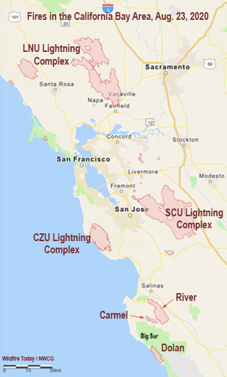
Below are updates on the largest incidents in California.
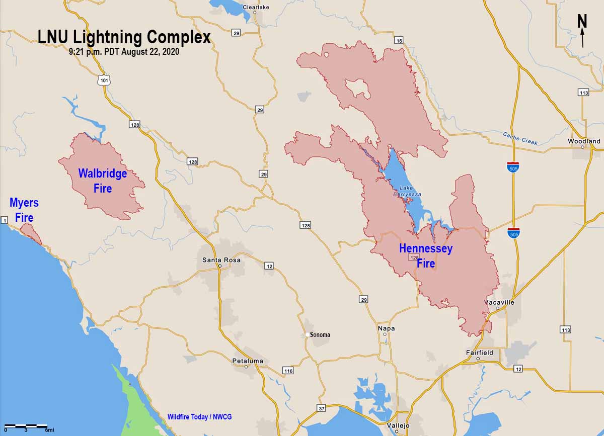
LNU Lightning Complex
- Updated August 24, 2020 at 7:38 p.m. PDT
- Location: North Bay
- Counties: Napa, Lake, Yolo, Solano, Sonoma
- Administrative Unit: CAL FIRE Sonoma-Lake-Napa
- Acres: 350,030. The largest fire in the complex is the Hennessey Fire, 293,602. The Walbridge Fire west of Healdsburg is 54,068, and the Meyers Fire on the coast north of Jenner is 2,360.
- Structures destroyed: 871
- Personnel assigned: 1,857
- Evacuation information: CAL FIRE LNU Twitter page
- Notes: Fires that merged to become the Hennessey Fire include Gamble, Green, Spanish, 5-10, Morgan, and Markley Fires.

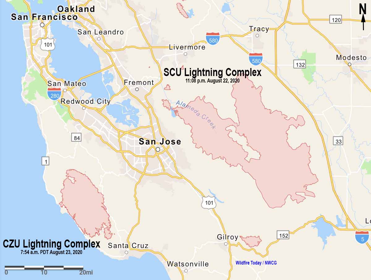
SCU Lightning Complex
- Updated August 24, 2020 at 7:44 a.m. PDT
- Location: South Bay
- Counties: Santa Clara, Alameda, Stanislaus, Contra Costa, San Joaquin
- Administrative Unit: CAL FIRE Santa Clara
- Acres: 347,196
- Structures destroyed: 12
- Personnel assigned: 1,336
- Evacuation information: CAL FIRE SCU Twitter page
- Notes: The complex is comprised of approximately 20 separate fires broken into three zones; the Canyon Zone, the Calaveras Zone, and the Deer Zone.
CZU August Lightning
- Updated August 24, 2020 at 7:44 a.m. PDT
- Location: South Bay
- Counties: San Mateo, Santa Cruz
- Administrative Unit: CAL FIRE San Mateo-Santa Cruz
- Acres: 74,000
- Structures destroyed: 163
- Personnel assigned: 1,511
- Evacuation information: CAL FIRE CZU Twitter page
- Notes: The fires continue to actively burn above the marine layer in the heavy timber and thick undergrowth. Damage Inspection Teams have begun to survey areas where fire activity has diminished and it is safe to do so. The number of destroyed structures reflected may change as teams continue to make progress. Firefighting resources are limited due to the number of fires burning throughout California. Limited visibility due to smoke is hampering aircraft operations. Approximately 77,000 people have been evacuated.

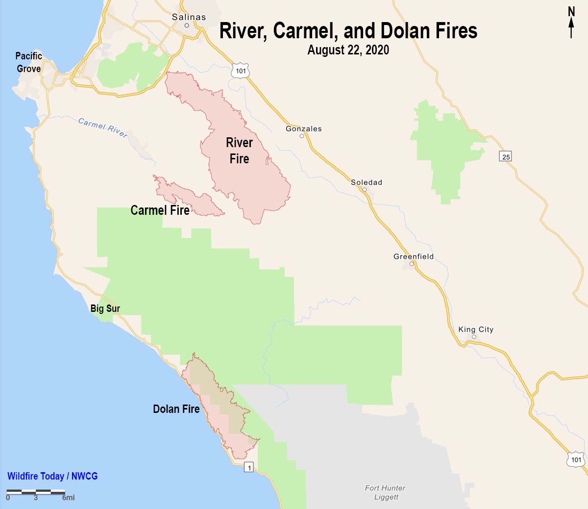
River and Carmel Fires
- Updated August 24, 2020 at 7:44 a.m. PDT
- Location: Five miles south of Salinas, near Pine Canyon Rd. and River Rd.
- Counties: Monterey
- Administrative Unit: CAL FIRE San Benito-Monterey
- Acres: 48,424
- Structures destroyed: 21
- Personnel assigned: 1,274
- Evacuation information: CAL FIRE San Benito-Monterey Twitter page, and see maps produced by Monterey County here.
- Notes: The Carmel Fire 2 miles southwest of the River Fire has burned 6,695 acres and destroyed 37 structures.
Dolan Fire
- Updated August 23, 2020 at 9:31 a.m. PDT
- Location: on the coast 10 miles south of Big Sur
- Counties: Monterey
- Administrative Unit: U.S. Forest Service, Los Padres NF
- Acres: 19,287
- Structures destroyed: 0
- Personnel assigned: 488
- Evacuation information:
- Notes: On private land and the Los Padres National Forest, threatening the communities of Hermitage, Partington Ridge, and Lucia. Multiple businesses, communications sites, parks and recreational sites are also threatened. On Saturday crews continued to focus on point protection operations around Hermitage and Lucia to the South, and Partington Ridge and Anderson Peak communications infrastructure to the North. As the threat diminishes these priorities will shift. After more resources arrive the plan will expand to include additional perimeter control operations. The fire was mapped for the first time Saturday night with a fixed wing aircraft. This accurate method is the reason for the large increase in the known acreage.

August Complex
- Updated August 24, 2020 at 7:44 a.m. PDT
- Location: 18 miles southwest of Red Bluff
- Counties: Tehama, Glenn, Lake, Mendocino, Trinity
- Administrative Unit: Mendocino National Forest and CAL FIRE
- Acres: 177,750
- Structures destroyed: 10
- Personnel assigned: 433
- Evacuation information:
- Notes: Of the 20 fires in the Complex the two largest are the Doe (136,430 acres) and Glade (13,088 acres). A Structure Damage Assessment Team has been ordered. Limited information is available about this incident.


Ronald,
You can have fleets and fleets of anything you can dream of. But if you don’t ever manage your forest, you will always be in the predicament you’re in now and never get ahead of bringing the forest back into balance with proper management.
If the forestry mapping planes are out due to lack of funding this is a shame and shows poor oversight or may be just the bad political climate we are in now.
I wonder if the cost of having a large drone fleet equiped to put out spot fires makes sense. The air force uses large drones that could be adapted. The advantage is that they could be airborne continuously if we have enough planes. Risking pilots seems unnecessary. Comments please..
Ron from Santa Barbara. ( no financial interest in this ).