Activity increases on Mosquito Fire 35 miles northeast of Sacramento

Spot fire approaches the community of Foresthill

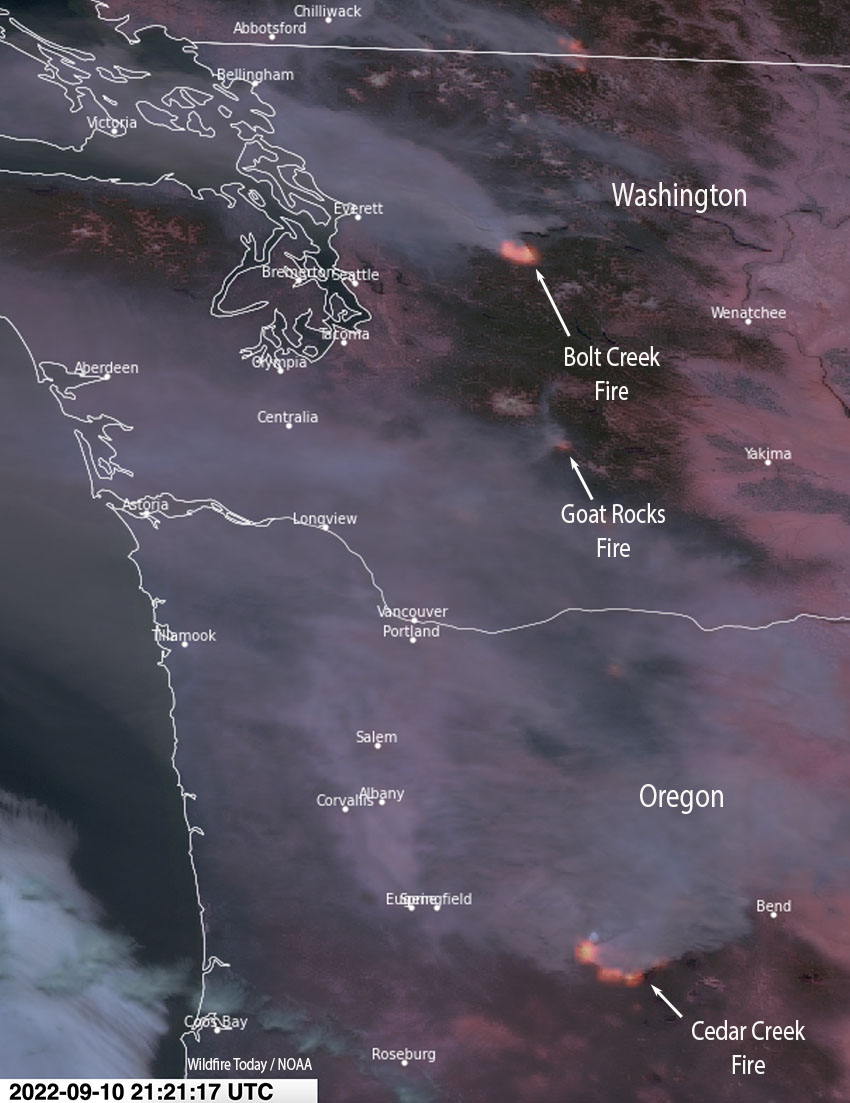
Updated at 12:41 p.m. PDT Sept. 14, 2022

In a Wednesday morning briefing on the Mosquito Fire Operations Section Chief Donald Fregulia said the westernmost part of the fire near Foresthill is being lined by fire crews today which should eliminate any further spread near the community. On Tuesday the fire spotted across the Middle Fork of the American River and ran upslope to, but did not cross, Foresthill Road. He did not mention that multiple structures and vehicles were destroyed Tuesday afternoon. However, due to previous work that had been done by property owners and firefighters, many structures were saved.

On the north side Tuesday night, firefighters conducted a defensive firing operation, working north along the Foresthill Divide Road. They reached Deadwood Road and then turned south. The intent is to prevent any further spread to the north in that area.

Mr. Fregullia said the fire had burned 58,544 acres and 3,052 personnel were assigned.


Updated 6:48 a.m. PDT Sept. 14, 2022

Mosquito Fire map, Forest Hill area
Mosquito Fire map, Forest Hill area. The red line was the perimeter at about 5 a.m. Sept. 14, 2022. The white line was the perimeter when mapped at about 7 p.m. Sept. 13, 2022.

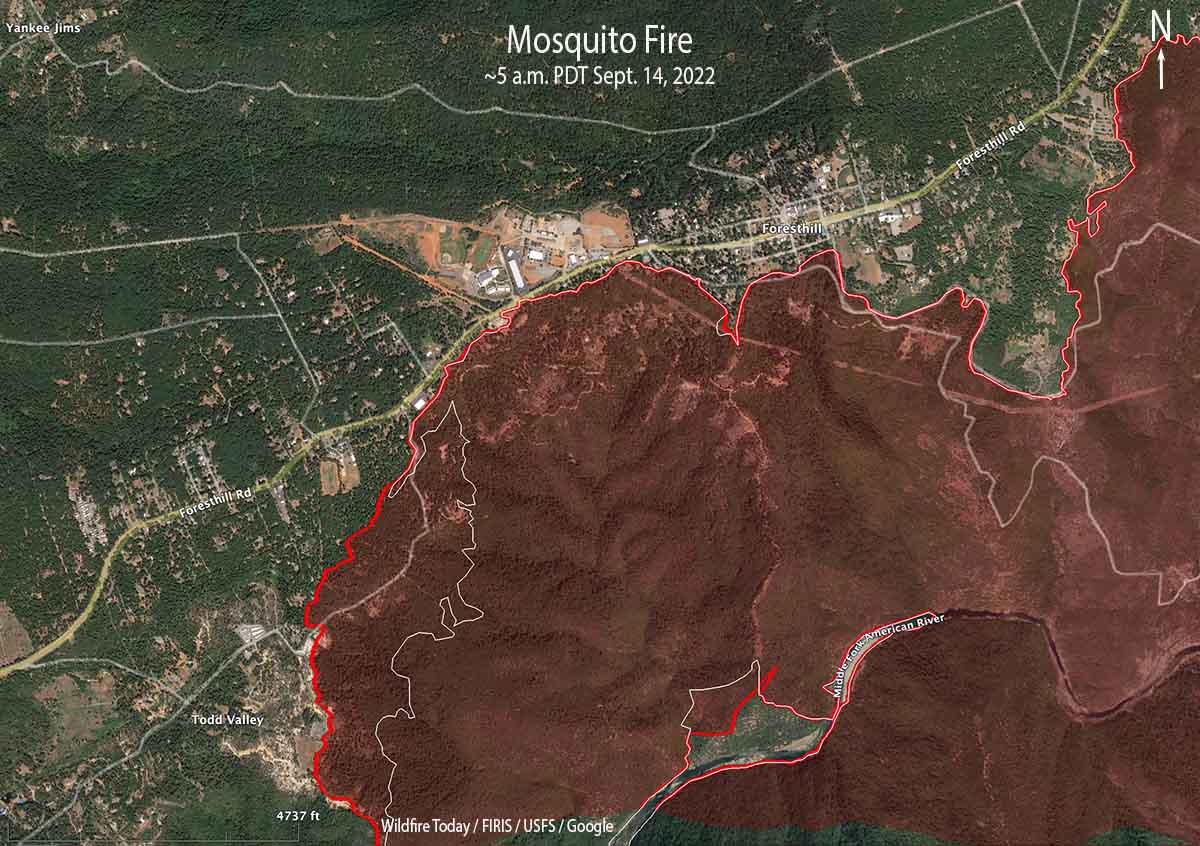
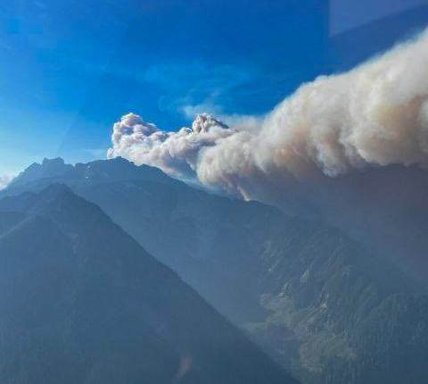
The spot fire that ignited across the Middle Fork of the American River below Foresthill, California Tuesday afternoon spread vigorously up the slope toward the community. It reached or came close to Foresthill Road in several places. Multiple structures and vehicles were destroyed across the street from the high school, but it did not cross the road. It could have been worse if not for the efforts of firefighters on the ground and numerous retardant and water drops by air tankers and helicopters.

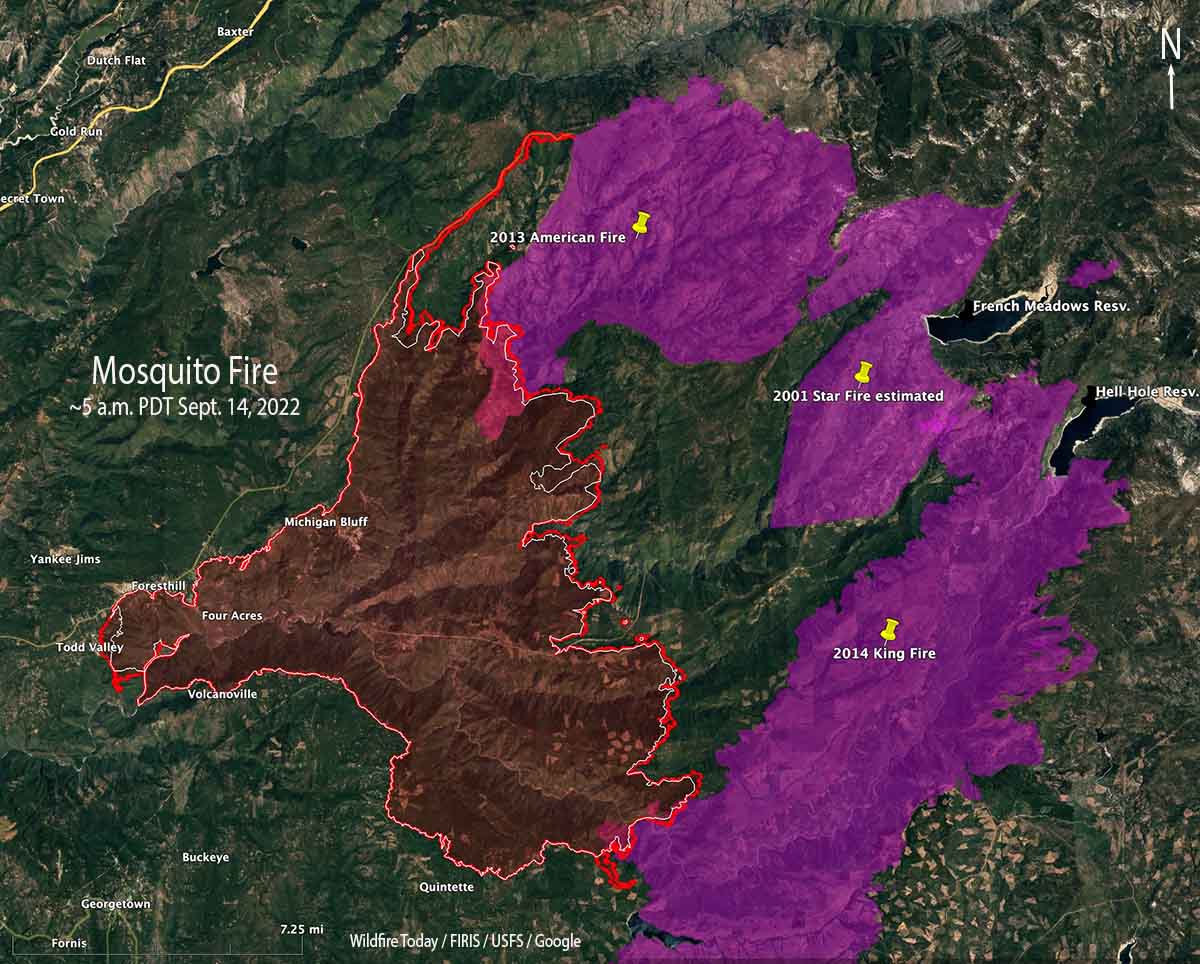
The FIRIS aircraft mapped the fire at 5 a.m. today and found that it had burned about 61,000 acres.

KCRA, a Sacramento TV station, in recent years has had to cover numerous massive, dangerous wildfires. Their experience shows in the below video that was part of their evening news on Tuesday. Farther down in the article is a Tweet that has almost 90 minutes of the station’s helicopter coverage as the fire was spreading up the slope to Foresthill.

Mosquito Fire map
Mosquito Fire map. The red line was the perimeter at about 5 a.m. Sept. 14, 2022. The white line was the perimeter when mapped at about 7 p.m. Sept. 13, 2022.

Updated 8:18 p.m. PDT Sept. 13, 2022

Mosquito Fire map
Mosquito Fire map. The red line was the perimeter at approximately 7 p.m. Sept 13, 2022. The white line was the perimeter at about 11 a.m. Sept. 12, 2022.

The FIRIS aircraft mapped the Mosquito Fire Tuesday evening. Most of the growth was on the east side, but the new spot fire near Foresthill added more than 1,100 acres. The total size increased to 58,000 acres.

To see all of the articles on Wildfire Today about the Mosquito Fire, including the most recent, click HERE.

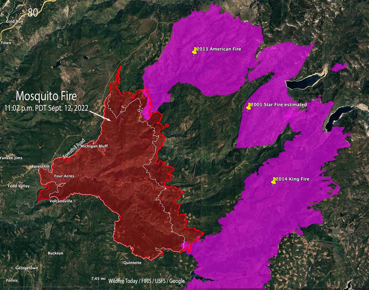
It did not spread as rapidly through the fires of 2013 and 2014 as it did in the areas with no recent fire history. But is has spread from 0.5 to 1.0 mile into the footprint of the 2013 American Fire.


Updated 5:35 p.m. PDT Sept. 13, 2022

Mosquito Fire spreads toward Foresthill, California
The Mosquito Fire spreads toward Foresthill, California at 4:59 p.m. PDT Sept. 13, 2022. KCRA-3 image.

KCRA has a live view of the Mosquito Fire as it threatens Foresthill, California. It may be in and out, limited by fuel and other factors; or, may be replaying video shot earlier.

Below, a 737 from New South Wales drops on the Mosquito Fire near Foresthill, CA.


5:19 p.m. PDT Sept. 13, 2022

Spot fire, Mosquito Fire, Foresthill California
Photo showing a spot fire on the Mosquito Fire below Foresthill, CA, 3:39 p.m. PDT Sept. 13, 2022. Looking north. FIRIS.

The activity of the Mosquito Fire at Foresthill, California was subdued Monday due to high humidities in the morning and a few scattered sprinkles. But today, Tuesday, the skies are mostly clear and the humidity has been lower, resulting in multiple convection columns building over the blaze.

Spot fire, Mosquito Fire, Foresthill California
Mosquito Fire, looking southwest from the Forest Hill camera at 2:44 p.m. PDT Sept. 13, 2022.
Spot fire, Mosquito Fire, Foresthill California
An air tanker can be seen at a spot fire on the Mosquito Fire, looking southwest from the Forest Hill camera at 3:20 p.m. PDT Sept. 13, 2022.

At about 2  or 2:30 p.m. a spot fire ignited on the western-most part of the fire south-southwest of Foresthill near the Middle Fork of the American River. It grew very quickly and was soon mapped by the FIRIS aircraft at 93 acres. Then the spot fire created another spot fire uphill and to the north, closer to Foresthill. Air tankers and helicopters were seen by the Foresthill camera working on the spots, but by 3:30 p.m. they had merged into one 300-acre spot fire spreading toward Foresthill.

At about 4:10 p.m. radio traffic indicated that the spot fire was close to reaching the area of the Foresthill Divide school.

Spot fire, Mosquito Fire, Foresthill California
Map showing the location of a spot fire on the Mosquito Fire, ~3:30 p.m. PDT Sept. 13, 2022. Data from FIRIS.
Two convection columns Mosquito Fire
Two convection columns on the Mosquito Fire. Looking northeast from the Auburn camera at 3:20 p.m. Sept. 13, 2022.

We will update this article as more information becomes available.

Hikers who escaped from Bolt Creek Fire documented, and now explain the ordeal

The predicted weather will slow the spread of the fire the rest of this week

8:45 a.m. PDT Sept. 13, 2022

Bolt Creek Fire hikers escape
Bolt Creek Fire Sept. 10, 2022. Image from Path Least Taken video

The two hikers who found themselves nearly entrapped by the rapidly spreading Bolt Creek Fire in northwest Washington near Skykomish have posted a video describing how they escaped.

After nearly reaching their goal of the top of Baring Mountain on Saturday September 10, they realized the smoke noticed earlier was from a fire that started that morning and had become a threat to their lives. The two of them shot video off and on during the entire hike, and on Sunday “Path Least Taken” posted an expertly-edited version on YouTube. He explained that he debated about publishing it, but did so “as an educational tool to point out all of the mistakes we made that ended up putting our lives in danger.”

During the escape they used wayfaring skills and technology tools to figure out how to descend the very steep slopes while avoiding the fire, which was at times exhibiting extreme flame lengths many times the heights of the trees, as you can see in the above image from their video.

When the Bolt Creek Fire was mapped Monday evening it had burned about 9,400 acres. In several places it has spread downhill nearly to US Highway 2. The fire activity was very much diminished Monday by much higher relative humidity. A weather station at Index northwest of the fire recorded very light winds Monday with the RH ranging from 57 to 92 percent, conditions not conducive to rapid fire spread.

Bolt Creek Fire 3-D map
Bolt Creek Fire 3-D map, looking NNW at 7:41 p.m. Sept. 12, 2022.

“It’s been a good day today for firefighters,” said Jim Cahill, a Washington State Department of Natural Resources spokesperson Monday evening.

As of Monday night US Highway 2 was closed from Milepost 32 to Milepost 50 and the community of Index was under a “Go Now” evacuation order.

The spot weather forecast for Tuesday predicts temperatures around 60 degrees, minimum RH of 87 percent, and light winds becoming 5 to 6 mph in the afternoon out of the northwest. Tuesday night the RH will rise to 100 percent and drop to only 86 percent on Wednesday. On Monday and Tuesday there is a 13 to 16 percent chance of very light rain, about 0.03″. The humidity is expected to remain mostly in the 80s and 90s through Sunday. The fire will not spread rapidly under these predicted conditions.

Bolt Creek Fire map
Bolt Creek Fire map. The red line was the perimeter at 7:41 p.m. Sept. 12, 2022. The white line was the perimeter about 48 hours previously.

Thanks and a tip of the hat go out to Patrick.

Light rain observed on parts of the Mosquito Fire

The fire 35 miles northeast of Sacramento was very active Sunday, spreading east up to a mile

3 p.m. September 12, 2022

Mosquito Fire map
Mosquito Fire map. The red line was the perimeter at 1:19 p.m. PDT Sept. 12, 2022. The white line was the perimeter on the morning of September 11, 2022. Three previous fire footprints are also shown.

On Sunday the east side of the Mosquito Fire spread as much as a mile to the east. Having already burned through most of the footprint from the 2007 Ralston Fire, for the first time it moved into the 2013 American Fire and the 2014 King Fire. It did not burn enough of those two more recent fires to get a good picture of how likely it is to spread completely through those eight and nine year old footprints.

At 1:19 p.m. Monday it was mapped by a fixed wing aircraft at about 48,500 acres. The blaze is 35 miles northeast of Sacramento.

Monday afternoon satellite and ground based cameras showed clouds, haze or smoke, and scattered thunderstorms in the general area of the fire. Light showers were reported in some areas. If strong outflow winds from passing thunderstorms hit the fire area without any rain it could increase the rate of spread significantly, sometimes in unexpected directions.

Crews working Sunday night on the southwest side between Foresthill and Volcanoville had to stop a strategic firing operation due to a small amount of rain. If conditions permit they hope to continue the operation today.

The weather forecast for Monday through Wednesday is for light to moderate winds of 2 to 9 mph generally from the southwest during the day  with minimum humidities in the 30s and 40s. Thursday through Saturday the winds will be very light while the humidity will be in the 40s.

In the video below watch how smoke from the Mosquito Fire overtakes Reno, Nevada.

Cedar Creek Fire in Western Oregon triples in size

Cedar Creek Fire 3-D map
Cedar Creek Fire 3-D map looking east at 10:45 p.m. Sept 10, 2022.

The Cedar Creek Fire that started August 1 in west-central Oregon was already very large at 27,512 acres on the morning of Thursday September 8. But as a result of dry, windy weather on the following two days when a mapping aircraft was over the fire at 10 p.m. Saturday it had more than tripled in size to 85,900 acres. That night the blaze was about 5 miles northeast of Oakridge.

Most of the growth was to the west, driven by strong easterly winds and dry fuels. Saturday evening while winds were from the west, firefighters on the western flank completed strategic burning operations near Eagle Butte, 5 miles northeast of Oakridge. The fire remained north of Highway 58, south of Forest Road 19, and east of Eagle Butte.

Cedar Creek Fire map, 10:45 p.m. Sept 10, 2022
Cedar Creek Fire map, 10:45 p.m. Sept 10, 2022.

The incident management team says 2,230 homes and 443 commercial structures remain threatened, but none have been reported as destroyed. The Office of the Oregon State Fire Marshal has committed seven task forces and an incident management team to the incident.

Saturday evening resources committed to the fire included 17 hand crews, 53 engines, and 8 helicopters for a total of 994 personnel. The estimated suppression costs so far are $47 million.

In the satellite photo below the Cedar Fire is producing the smoke seen in the lower portion of the image.

Satellite photo, Bolt Creek and Cedar Creek fires Sept. 10, 2022
Satellite photo, Bolt Creek and Cedar Creek fires Sept. 10, 2022. Processed by Pierre Markuse.

New fire pushes smoke into northwest Washington

The Bolt Creek Fire near Skykomish is growing rapidly

Updated 8:50 a.m. PDT Sept. 11, 2022

Bolt Creek Fire map at 8:21 pm Sept. 10, 2022
Bolt Creek Fire, mapped by a fixed wing aircraft at 8:21 pm Sept. 10, 2022

The Bolt Creek Fire 42 miles north-northeast of Seattle is producing smoke that is moving into Everett and Bellingham. The fire spread eight miles to the northwest after it started Saturday near Skykomish off US Highway 2. So far it has remained north of the highway as it burned past Grotto and Baring. A US Forest Service mapping flight Saturday night determined it had blackened about 7,660 acres and was 3 miles southeast of Index. This data from a fixed wing aircraft is much more accurate than some of the maps being posted on social media.

To see all articles on Wildfire Today about the Bolt Creek Fire, including the most recent, click HERE.

An 18-mile corridor of Highway 2 remains closed and evacuations are in effect. Snohomish County has the details.

This kind of wildfire activity is exceptionally rare for the western slopes of the central Cascades in Washington.

Satellite photo, Bolt Creek and Cedar Creek fires Sept. 10, 2022
Satellite photo, Bolt Creek (on the north) and Cedar Creek fires Sept. 10, 2022. Processed by Pierre Markuse.

Two hikers that were on the mountain had a harrowing escape from the fire. They called 911 and were told it was too dangerous to rescue them by helicopter, but eventually after scrambling down steep terrain they made it out of danger. (Update, Sept. 13, 2022: the hikers documented their escape from the fire.)


3:47 p.m. PDT Sept. 10, 2022

Bolt Creek Fire near Skykomish, Washington at 1:54 p.m. PDT September 10, 2022
The red dots represent heat detected by a satellite on the Bolt Creek Fire near Skykomish, Washington at 1:54 p.m. PDT September 10, 2022. The extent of heat displayed may be exaggerated. The fire, at that time, may not have been as large as depicted here.

Several wildfires are pushing smoke into western Oregon and Washington. The Bolt Creek Fire, which started Saturday in northwest Washington near Skykomish off US Highway 2 is growing very quickly. It is producing a great deal of smoke blowing to the northwest toward Everett and Bellingham.

Bolt Creek Fire, September 10, 2022. Washington State DNR.

Our very, very rough estimate of the size, based on the imprecise satellite heat data, is that the Bolt Creek Fire had burned more than 2,500 acres by 1:54 p.m. PDT Saturday.

Satellite photo showing smoke from fires in Washington and Oregon
Satellite photo showing smoke from fires in Washington and Oregon, 2:21 PDT Sept. 10, 2022.

A section of Highway 2 is closed.

Snohomish County has evacuation information about the Bolt Creek Fire.

A fire south of Mount Rainier National Park, the Goat Rocks Fire, is also producing smoke, but it is heading generally west to the Centralia area. As of Friday it had burned about 1,500 acres.

The smoke from a very large fire that has been burning since August 1 in west-central Oregon, the Cedar Creek Fire, is sending smoke into Washington. The Washington State DNR said today that smoke from that 35,000-acre fire is being lofted to higher altitudes and is not expected to contribute significantly to further reductions in air quality at ground level. It will actually help keep temperatures down a few degrees Saturday afternoon, they said, and limit the minimum relative humidity values experienced in the Puget Lowlands.

Bolt Creek Fire, September 10, 2022. Washington State DNR.

Rain from tropical storm Kay slows spread of Southern California fires

Precipitation, vicinity of Fairview Fire,
Precipitation, vicinity of Fairview Fire, 24 hours ending 5 a.m. Sept. 10, 2022

Rain that began falling at about 1 p.m. Friday slowed the spread of the Fairview and Radford Fires in Southern California. By 5 a.m. Saturday weather stations near the fires had recorded amounts ranging from 0.05″ to 0.28″.  Much higher amounts were found at a few locations in the mountains east of the Fairview Fire.

The precipitation is expected to continue into Sunday morning.

Precipitation, vicinity of Radford Fire,
Precipitation, vicinity of Radford Fire, 24 hours ending 5 a.m. Sept. 10, 2022
Fairview Fire map Sept. 10, 2022

There was a concern that very strong winds generated by tropical storm Kay would cause problems at the fires, but those did not materialize, at least not by 5 a.m. Saturday.

Precipitation, Southern California, 24 hours ending 5 a.m. Sept. 10, 2022

As of 5 a.m. the rain had occurred as far north as Santa Barbara and Edwards Air Force Base. It did not affect the rapidly growing Mosquito Fire 27 miles west of Lake Tahoe, CA.

Meanwhile, Red Flag Warnings are in effect Saturday for the northwest corner of California and the west sides of Washington and Oregon.

Red Flag Warnings September 10, 2022

The forecast for vertically integrated wildfire smoke predicts impacts in most of the Western States Saturday afternoon.

Forecast for smoke
Forecast for smoke at 1 p.m. MDT Sept. 10, 2022. NOAA