Remembering Jan van Wagtendonk, who shaped fire management in Yosemite National Park

Jan van Wagtendonk
Jan van Wagtendonk. NPS photo.

From the National Park Service, Yosemite National Park, August 12, 2022:

“We are sad to report that pioneering Yosemite scientist Jan van Wagtendonk died on July 15, 2022.

“Jan was a Yosemite and National Park Service legend: an accomplished scientist, a preeminent fire ecologist, a wilderness advocate, and a beloved colleague. He was an innovative wilderness manager, coming up with the trailhead quota system that we still use today to protect wilderness while ensuring that hikers are free to enjoy that wilderness on their own terms. His impact affects fire policy to this day as one of the authors of the first federal fire policy in 1995. Jan possessed an amazing intellect, deep humility, a sharp wit, and a profound love of Yosemite and the Sierra Nevada.

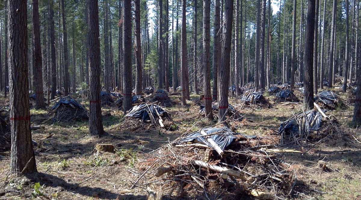
“Jan was a strong advocate for returning fire to the Sierra landscape. His pioneering use of prescribed fire in the early 1970s in and around the Mariposa Grove started us on the path to reestablishing an ecological balance lost in over 100 years of fire suppression. There is poetry, in the words of Jan’s son Kent, that in Jan’s final days the fruits of those efforts had a direct and dramatic effect in saving the Mariposa Grove from the Washburn Fire, which started just outside of the grove.

“Our heartfelt condolences go to Jan’s family and wide circle of friends and colleagues. He was one of a kind, and will be deeply missed.”


The article below from the US Geological Survey was originally written in 2020, based on an interview with Jan van Wagtendonk in 2019:


The first thing to know about emeritus scientist Jan van Wagtendonk is that he loves trees—always has and always will. As a kid, he looked at trees, inventoried trees, wrote a report on trees. One of his neighbors as a kid described young Jan by saying “I never saw him inside.”

He was a forest scientist before he even knew that was a thing you could be.

At age 13, van Wagtendonk was on two-months long family camping trip when he met a forest ranger. Upon realizing that he, too, could work with trees for a living, van Wagtendonk decided to become a forester. Several years later, he entered the forestry school at Purdue University in Indiana.

Wildfire 101

One day in college, van Wagtendonk found a listing on a campus bulletin board for a summer job on a wildland firefighting crew in Oregon. He applied, got the job, and headed West. It was his first experience with wildfire, the subject that would become his life’s work. Unsurprisingly, he loved Oregon—it had great trees—and ended up transferring to Oregon State University. He would spend several summers on fire crews in Oregon and then Alaska, first mopping up the final embers of wildfires and later working as a smoke jumper. The job was to put the fires out. Years later, his job became more about the opposite—reintroducing fire to Western forests.

Van Wagtendonk claims he “had no inkling about fire ecology at all” at the time, but he thinks that several experiences he had during his smoke jumping days may have shaped his thinking as a forest scientist and led him to fire ecology. In one instance, he was assigned to a put out a fire in a remote part of Alaskan tundra. The landscape was dotted with bird nests. The flames were about two inches high, and the fire crept along at about a foot per minute. Van Wagtendonk was struck by the birds’ seemingly nonchalant reaction to the fire: “the fire would be coming, they’d go up like this”—he mimes a bird flapping its wings and rising into the air a few inches as he tells this story— “fire’d go by, and they’d go right back on the nest.”

Many wildfires, he found, were not destructive. They burned slowly, part of the landscape.

After graduating from Oregon State University, van Wagtendonk served in the army as an officer in the 101st Airborne Division and as an advisor to the Vietnamese army. But after four and a half years, he was ready to move on and applied for graduate school, eventually ending up studying fire ecology under Dr. Harold Biswell at UC Berkeley.

Bringing Fire Back to the Forest

Van Wagtendonk began his study of fire ecology just as it was coming into its own as a field and taking forestry by storm. When van Wagtendonk was an undergraduate forestry major, fire ecology was only obliquely mentioned.

Dr. Harold Biswell (L) and Jan van Wagtendonk
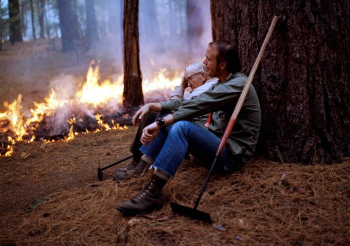
NPS sit against a ponderosa pine near a prescribed fire in 1970 in Yosemite National Park. Van Wagtendonk’s dissertation work on prescribed fire in Yosemite around this time led to prescribed burning guidelines still in use in Yosemite today, and a long career in forest and fire science with the federal government.

At the time, he says, “fire had not been truly accepted as an academic discipline, certainly not something you tell people you’ll set.”

Biswell, van Wagtendonk’s graduate school mentor, was something of an outlier. Biswell would conduct prescribed burns and then take students, scientists, ranchers, land managers, and interested citizens out into the field and show them what he was doing.

Those efforts paid off. By 1968, the year that van Wagtendonk began his doctoral dissertation, lessons from fire ecology were starting to reshape federal fire management policy. The National Park Service, in particular, began incorporating prescribed fire programs in recognition of the ecological role of wildfire; other agencies followed suit in the decade that followed.

Van Wagtendonk’s dissertation research played a major role in this transition. Biswell’s guidance for prescribed burning was based on experience.

“He could go out in the woods and snap a twig and say, okay it’s ready to burn,” as van Wagtendonk tells it. That method wouldn’t do if prescribed burning was to be adopted more broadly. For his dissertation, van Wagtendonk set out to quantify Biswell’s prescriptions. Van Wagtendonk conducted his work at Yosemite National Park after being turned down by the Forest Service. The result? A set of guidelines for prescribed burning that are still in use in Yosemite today.

From Wilderness Management to Megafires: A Career at Yosemite

Soon afterwards, van Wagtendonk was offered a job at Yosemite—and 48 years later, he’s still there, first as an employee and now as an emeritus. The decades have brought changes—to fire ecology, to the park, and to federal government science–and lots of fascinating research about fires, forests, and the way people engage with wild places.

In the 90s, van Wagtendonk moved from the National Park Service to the USGS along with many other federal scientists, keeping his home base at Yosemite. He was among the original scientists of the USGS Western Ecological Research Center that served on the founding Science Council under its first Director, Anne Kinsinger, who is currently the USGS Associate Director for Ecosystems. That Council helped form the Center into the outstanding scientific institution that it is today.

Van Wagtendonk’s research over the years has touched on many aspects of fire science. He has developed methods for mapping fuel types, assessed the effects of fire suppression and fuel treatments like prescribed fire, analyzed patterns of lightning strikes, and studied the influence of fire on owls and small mammals. Over the years, van Wagtendonk has incorporated new technology and methods to the study of fire and wilderness, including GIS, remote sensing, and computer modeling, not only using these tools but also publishing highly-cited guidance on using these tools for fire science.

Van Wagtendonk’s work hasn’t been limited to fire research. Early on in his time at Yosemite, he began to study recreation in the park, especially in its backcountry wilderness areas. Backcountry had increased drastically in the 1960s and ‘70s. Van Wagtendonk described the changes in a 1981 paper, writing that in 1972, managers found trampled vegetation, eroded trails, and up to 200 people camped at popular sites. In the 1970s, the park implemented mandatory permit and quota systems for backcountry use that were informed by van Wagtendonk’s research.

Van Wagtendonk has witnessed Yosemite and fire science shift over the decades. In several publications, he’s traced the history of fire policy and management in Yosemite and beyond. Visitor numbers have skyrocketed at Yosemite, and larger wildfires burn in California as the climate warms. In the past two decades, his research has given more attention to today’s megafires and climate change. There’s still a lot to learn about the future of fire.

It can take a long time for new science to really shape management on the ground, but van Wagtendonk marvels at how far we have come, and how much the still-young field of fire ecology has influenced policy already.

“It has been very gratifying to see my work actually be used in park management and beyond,” he says.

Van Wagtendonk has been in Yosemite for 48 years, and still can’t get enough of it. When he’s not working on his writing and research, he loves to hike and backpack the trails.

“I’ve hiked every trail in the park,” he says. “I’ve been backpacking every summer. . . I’m at the point where I’m going back to places I’ve liked the most . . .but I want to be able to keep doing that as long as I can, do it now before my legs give out.”

Jan van Wagtendonk
Jan van Wagtendonk in the Mariposa Grove, Yosemite National Park, approximately 2019. USGS photo.

Thanks and a tip of the hat go out to Jim, Gerald, and Kelly.

Wildfire acres burned to date in United States (outside Alaska) is lower than average

Precipitation, 7 days
Precipitation, during the seven days ending at 11 a.m. MDT August 13, 2022.

It seemed to me that over the last few weeks the wildfire activity has been slower than typical for this time of the year, so I did a little digging. Using historical data from the National Interagency Fire Center and acres burned to date from the August 13 national Situation Report, it turns out that Alaska has burned nearly three times their 10-year to-date average while the other 49 states combined are running 12 percent below the to-date average.

Over the last 10 years Alaska’s average acres burned in a full year is 1.1 million. This year they are at 3.1 million, more than the other 49 states combined. There has been a major increase in Alaska acres burned after mid-August in only 2 of the last 18 years. And it has been fairly quiet there, fire wise, for the last four weeks.

So far this year, fires in the other 49 states have blackened about 2.8 million acres, 12 percent below the to-date 10-year average of 3.2 million. The 49 states typically burn 6.2 million in a full year, so if this year turns out like the average of the last 10, we’re about half done.

The Situation Report does not break out data for Alaska and the other 49 states, so just looking at their 50-state numbers a person would see that the 5.9 million acres burned to date is 27 percent higher than the average of 4.3 million, when actually the +27 percent figure is very wrong for both Alaska and the lower 49 states.

We usually separate Alaska stats because fires in that huge state are managed far differently from the other 49. Most of them are not fully suppressed since they are less likely to endanger people or private property than in the lower 49 states. The second reason is that the fire occurrence is extremely variable, with the acres burned since 1990 ranging, for example, from 43,965 acres in 1995 to 6,645,978 in 2004. Including the Alaska numbers in the total would skew the data for the other 49 states making it more difficult to spot trends.

Wildland fire potential for September, 2022
Wildland fire potential for September, 2022. NIFC.
Wildland fire potential for August, 2022
Wildland fire potential for August, 2022. NIFC.

Leilani Fire burns more than 20,000 acres in Hawaii

Started in a US Army training area in July

Updated 8:55 a.m. PDT August 13, 2022

More accurate mapping on Friday found that the Leilani Fire on Hawaii’s Big Island was not as large as the earlier 25,000-acre estimate, and had instead burned 16,400 acres as of Friday afternoon. Fire officials said it was about two miles from Highway 190.

From BigIslandNow, August 12 at 3:41 p.m. HST:

“The last two days the fire was mostly burning in invasive fountain grass. It’s the first plant that comes in after fire disturbance,” said Steve Bergfeld, the Hawaii Island Branch Manager for the Hawaii Department of Land and Natural Resources Division of Wildlife, and one of three incident commanders on the fire. “Unfortunately, the fire has moved into some dryland forest which has native ōhiʻa lehua and we are trying to keep flames away from this sensitive area.”

Seven contracted bulldozers left a fire command post this morning, leading the way into the fire area, where the heavy machines continued building wide fire lines. Five helicopters from the U.S. Army’s Pōhakuloa Training Area are conducting aerial water drops. It’s hoped this all-out assault on the Leilani fire will result in firefighters gaining the upper hand in the next few days.

The video below was shot Friday August 12 by the Hawaii Department of Land and Natural Resources (DLNR).

The photos below are still images from DLNR videos.


12:01 p.m. PDT August 12, 2022

Map of the Leilani Fire, morning of Aug. 12, 2022
Map of the Leilani Fire. The red and tan dots represent heat detected by a satellite early in the morning Aug. 12, 2022. The small red perimeter was the extent of the fire on July 22, 2022.

A fire in Hawaii that the Hawaii Department of Land and Natural Resources (DLNR) said has been burning for weeks has suddenly become much more active. The Leilani Fire started in the US Army’s Pohakuloa Training Area on the Big Island and was mapped July 22 at 2,362 acres. Recent strong winds and extremely dry conditions have helped it spring back to life and was reported Thursday evening to be 25,000 acres.

Satellite heat detections early Friday morning appeared to show it has advanced out of the Department of Defense training area and spread northwest onto state land, approaching the Daniel K. Inouye Highway (Highway 200). State officials said it was about a mile south of Hawaii Belt Road (Highway 190).

Leilani Fire big Island Hawaii
Leilani Fire, image from video by Hawaii Department of Land and Natural Resources.

Officials with the DLNR said Thursday it was not threatening any homes but dry fuels and winds gusting up to 30 mph are making it difficult to contain the blaze. It is burning through brush and grass dessicated during the drought.

A spokesperson for the Army told The Associated Press that while there is active military training in the area, the cause of the fire remains under investigation.

Leilani Fire big Island Hawaii
Leilani Fire, image from video by Hawaii Department of Land and Natural Resources.

“There are units up there training, I can’t confirm or deny if live fire was taking place,” said Michael O. Donnelly, chief of external communications for the U.S. Army Garrison Hawaii. “It’s business as usual, but the exact cause we don’t know.”

Leilani Fire big Island Hawaii
Leilani Fire, image from video by Hawaii Department of Land and Natural Resources.

Fire south of Bordeaux in France forces 10,000 to evacuate

Q400 drops retardant on a fire in France
A Q400 drops retardant on a fire in France. Reuters.

The number of acres burned this year in France through mid-August, 148,000, is six times the full-year annual average over the last 15 years. Currently there are eight large fires in the country.

In the southwest, the Gironde region south of Bordeaux has been especially hard hit. One of the fires started a month ago and burned 14,000 acres. It was thought to be controlled, but officials said it either “reignited” on Tuesday or arson may have played a role. Since then it has blackened an additional 18,000 acres, destroyed or damaged 17 homes, and prompted about 10,000 residents to evacuate.

It has forced the closure of the A63 motorway, a major route to Spain between Bordeaux and Bayonne.

The difficulty in suppressing the fires is being attributed to record-breaking drought, strong winds, and high temperatures occasionally hitting 104 Fahrenheit in the southwest.

wildfires in France in the Gironde region map
The red areas represent heat detected at wildfires in France in the Gironde region south of Bordeaux during the 31-day period ending August 12, 2022. FIRMS.

International assistance is coming in the form of 65 firefighters from Germany, others from Romania, Austria, and Poland, and water scooping air tankers from Greece and Sweden.

firefighters Romania are assisting France
Dozens of firefighters from Romania are assisting France

France has a fleet of nine S-2 air tankers and has purchased six Q400 MR air tankers, with at least four having been delivered.

There is also large fire in the mountainous Serra de Estrela park in central Portugal, where 24,000 acres have burned. It is being fought by about 1,500 firefighters.

map Fires Portugal Serra Da Estrela Natural Park
The red areas represent heat detected by satellites in Portugal’s Serra de Estrela Natural Park during the 7-day period ending August 12, 2022.

Report: US Forest Service is sometimes overstating fuel management accomplishments

Forest thinning in the Umpqua National Forest
Forest thinning project in the Umpqua National Forest. Credit, Oregon State University.

NBC News conducted an investigation into some of the claims and statistics about vegetation management projects that are designed to improve forest health and/or and reduce the threat of wildfires. The emphasis of the very lengthy article about their findings was not so much to question the need or effectiveness of the hazardous fuel reduction projects, but to examine their claims of accomplishments, which are sometimes misleading.

Many fuel management projects on National Forests include multiple treatments of a single area. There can be some combination of thinning, pruning, piling, chipping, or prescribed burning, all considered independently and occurring at different times. In an extreme scenario, if the project was 100 acres and five different treatments occurred, each might be reported as accomplishing 100 acres of fuel treatment. They then tell Congress they treated 500 acres.

The NBC article gave an actual example of a project on the San Bernardino National Forest in Southern California near Big Bear Lake. The 173-acre project had multiple treatments. From the article:

They first [step] appeared in 2016, when the Forest Service assigned workers to cut trees to reduce the area’s density. The agency came back two years later, pruning the remaining trees and piling the cut wood across the full 173 acres, then chipping 52 acres of it. A few months later, workers burned 18 acres of the piles.

The pruning, piling, chipping and burning were entered as separate items in the database and the agency reported them as 416 acres of treated land in its 2019 fiscal year totals to Congress. In summer 2021, it burned the remaining 155 acres of piles, reporting them in that year’s totals.

The Forest Service’s efforts ultimately reduced fire risk on 173 acres of land, but they were reported to Congress as 744 acres over four fiscal years.

“These acres are reported six times because we must request funding to accomplish the full suite of activities on the same 173 acres,” said [Wade] Muehlhof, the service’s spokesperson. “Each of these activities needs to be planned and budgeted for annually.”

The Forest Service tells Congress that it reduces wildfire risk on more than 2.5 million acres of its land every year. But this process of recounting the same acres any time more than one type of work is completed means that far less land is protected from damaging fire than is being reported.

NBC estimates that nationwide the FS has overstated accomplishments by 2.5 million acres, or 17 percent. In California the numbers are higher, 27 percent in the past five years, and by roughly 35 percent in the places near the most people, the state’s wildland urban interface areas.

The NBC article was written by Adiel Kaplan, with assistance from Monica Hersher and Joe Murphy.

Ranger Jake describes the damage in Yellowstone National Park caused by the June 13 flooding

June 13, 2022 flood in Yellowstone National Park
June 13, 2022 flood in Yellowstone National Park. YNP image.

Yellowstone National Park released a video yesterday describing the massive damage to the park’s infrastructure that occurred June 13 when unseasonably warm weather, melting snow, and very heavy rain produced widespread flooding across the north end of the park. Yellowstone Digital Communications Specialist, Jake Frank, gives his first-hand account of the 500-year flood event.

These photos are still images from the video below.

June 13, 2022 flood in Yellowstone National Park
June 13, 2022 flood in Yellowstone National Park. YNP image.
June 13, 2022 flood in Yellowstone National Park
June 13, 2022 flood in Yellowstone National Park. YNP image.
June 13, 2022 flood in Yellowstone National Park
June 13, 2022 flood in Yellowstone National Park. YNP image.

More information is at www.nps.gov/yell