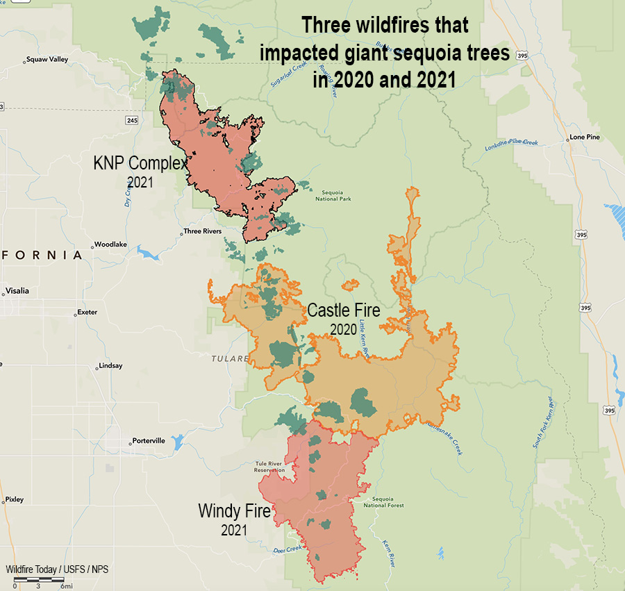
Three fires in two years that killed giant sequoia trees. The darker green areas represent groves of giant sequoias.
The U.S. Forest Service distributed information yesterday saying there are areas still burning in giant sequoia groves after wildfires that occurred in the Castle and Windy Fires of 2020 and 2021.
From the Sequoia National Forest, July 23, 2022:
Three fires were discovered this week, still smoldering inside the 2020 Castle and 2021 Windy Fires. Firefighters from Sequoia National Forest quickly reached two, and the third could not be reached safely due to the dense stand of fire-killed trees surrounding it.
The 1-acre Cougar Fire was found burning in the Red Hill Giant Sequoia Grove near the Tule River Indian Reservation boundary. Less than a half mile away, the ¼-acre Crawford Fire was reported by fire personnel responding to the Cougar Fire. Both were caused by a smoldering giant sequoia tree leftover from last summer’s Windy Fire.
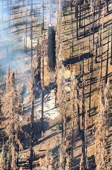
Burning area in giant sequoia grove. US Forest Service. Photo distributed July 23, 2022. (Date of the photo and name of fire not provided)
Fireline was constructed by hand to stop each fire from spreading further. Heavy material: treetops, limbs, and trunks of previous fallen trees continue to smolder underneath these still-standing sequoia trees, weakened by the fire burning inside them. Fire personnel will continue to mop up and extinguish what they can without jeopardizing their safety by having to work under a burning giant sequoia tree. Neither the Cougar nor Crawford Fires pose an immediate risk to nearby communities.
On Thursday, a third fire was reported southeast of Camp Nelson in the Belknap Giant Sequoia Grove. Helicopter personnel located this fire deep inside the burned area of the 2020 Castle Fire. Due to its remote location, numerous standing hazard trees endangering fire personnel, and minimal chance of escape, this fire will be monitored from a distance and by air.
There have been several instances of smoldering trees, most of them large diameter giant sequoias, observed and reported in both the Castle and Windy Fire burned areas. These are likely to continue as dry conditions persist. Firefighter safety is a priority when determining how best to extinguish these types of fires. They may have to be monitored until the trees fall on their own and can be managed safely on the ground.
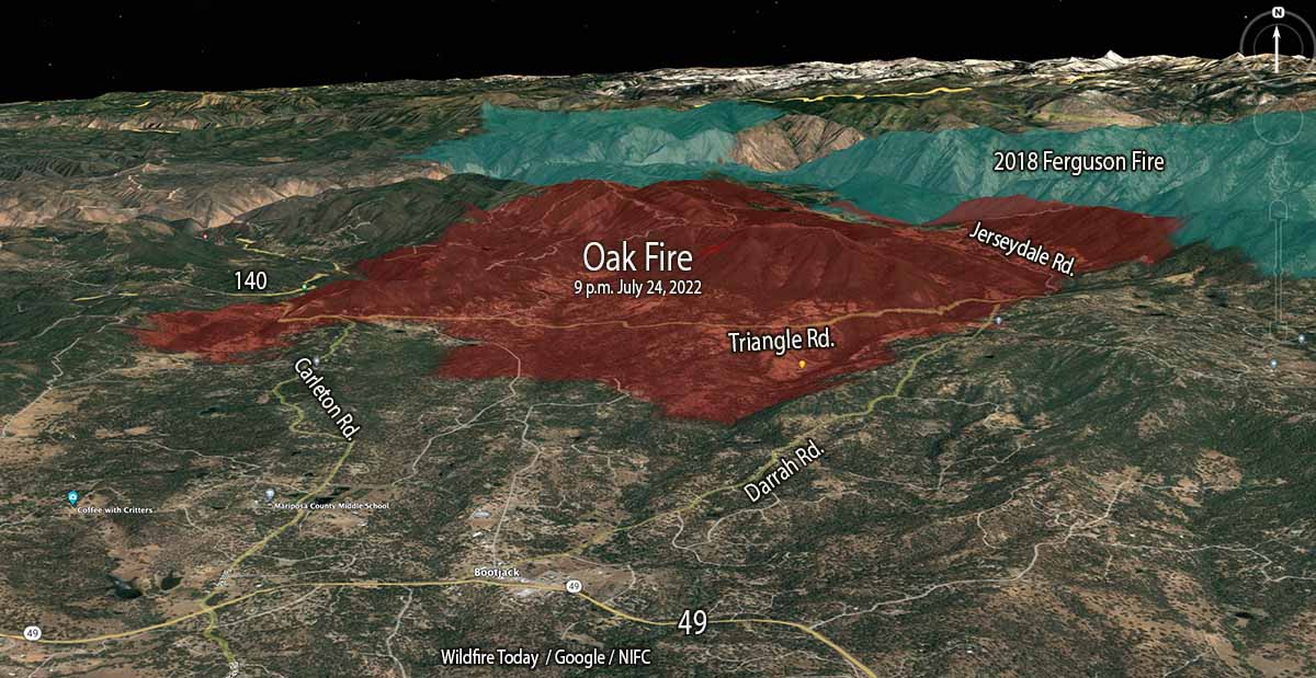
Oak Fire 3-D map, looking north at 9 p.m. July 24, 2022.
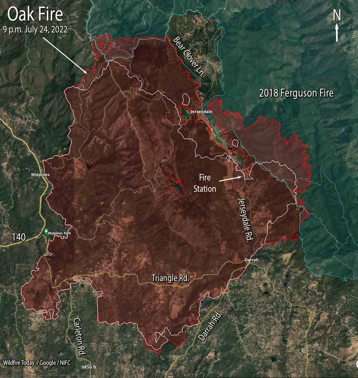
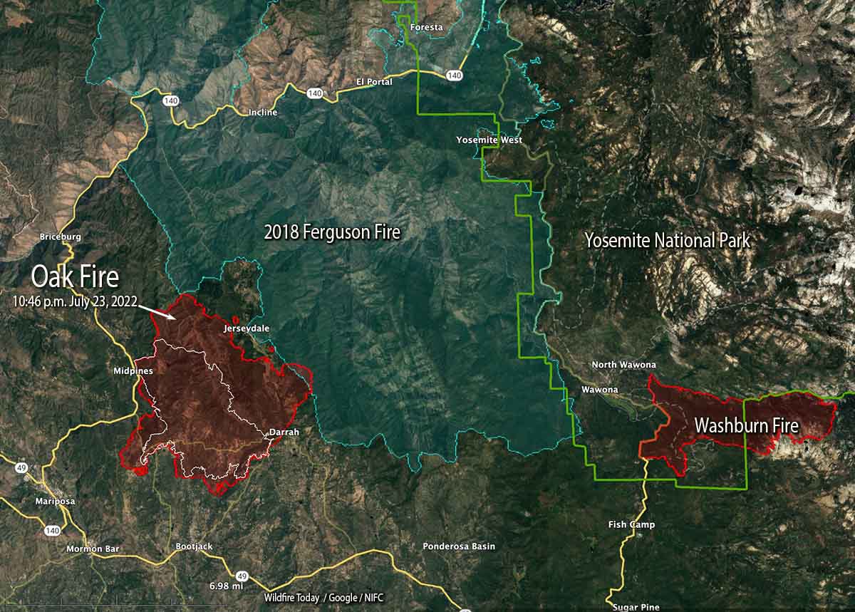
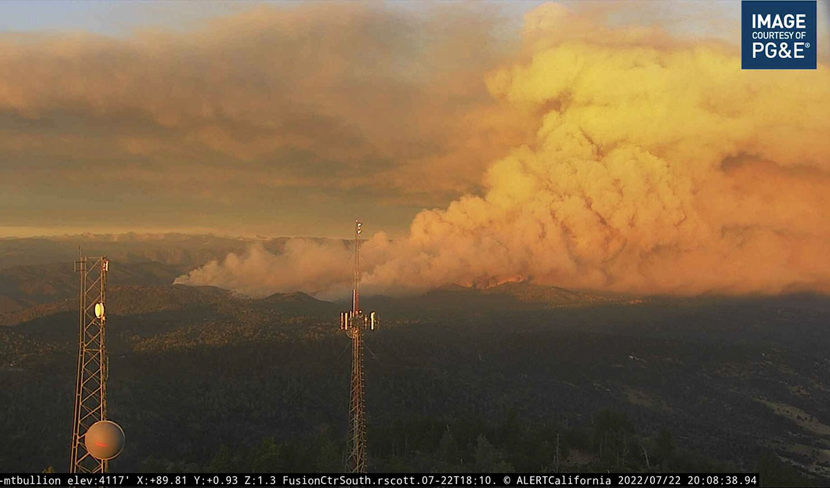
The Oak Fire northeast of Mariposa, California was very active Sunday especially on the east side where firefighters worked to minimize the spread beyond Footman Ridge and battled, successfully, to keep it from crossing Bear Clover Lane.
The blaze was mapped Sunday night at 16,791 acres.
To see all articles on Wildfire Today about the Oak Fire, including the most recent, click HERE.
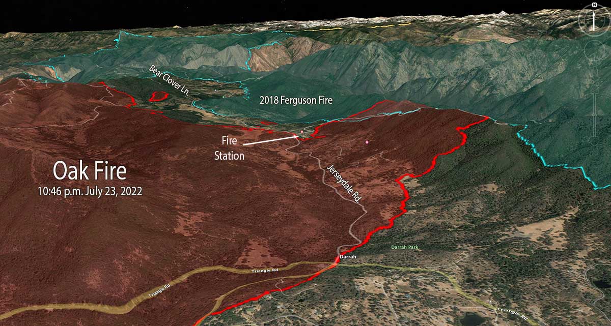
Part of the western edge of the Ferguson Fire that burned 96,000 acres in 2018 was south of Jerseydale and east of Jerseydale Road. That four-year-old footprint is not stopping the Oak Fire, but the rate of spread and intensity is greatly diminished as it burns, giving firefighters more options to put in direct fireline on the edge where they can, and construct indirect lines out ahead. Drops from helicopters and air tankers are also more effective in the lighter fuels.
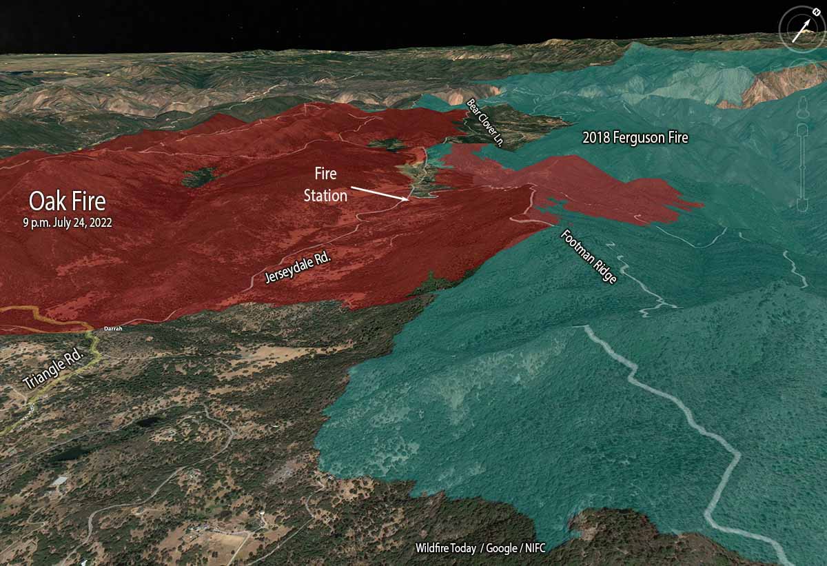
Oak Fire 3-D map, east side, looking northwest at 9 p.m. July 24, 2022.
While personnel have their hands full slowing or stopping the spread on the east and north sides, the south and west perimeters are looking much better. Direct fire line has been completed in many areas and tactical burning has helped to secure the edge.
In a community meeting Sunday evening fire officials said that soon after the fire started at 2:10 p.m. Friday it was creating spot fires two miles ahead of the main fire. At that time there was little the limited number of firefighters at the scene could do other than protect lives and structures and help with evacuations.
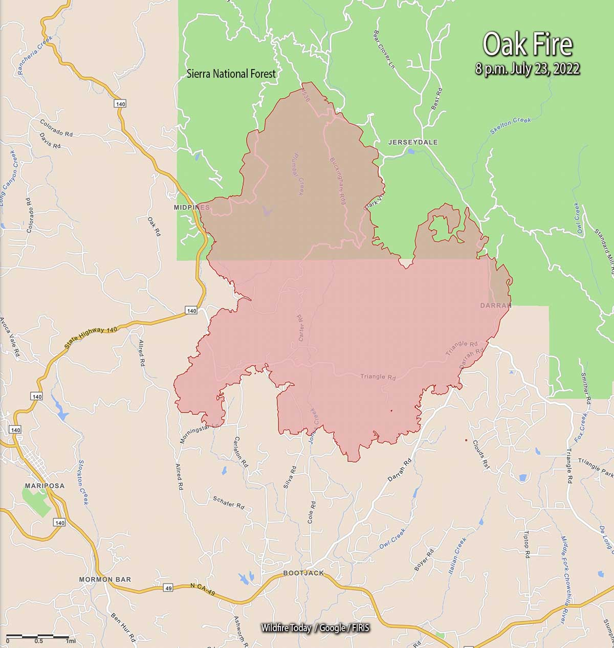
Oak Fire map. The red line was the perimeter at approximately 9 p.m. July 24, 2022. The white line was the perimeter about 23 hours before.
The number of structures reported as having been destroyed remains at 10, but that number will change after the two-person damage assessment team begins to report their findings, which may be released today.
Resources on the incident include 17 helicopters, 225 fire engines, 58 dozers, 23 water tenders, and 51 hand crews for a total of 2,093 personnel.
Oak Fire, looking northwest from Miami Peak at 7:18 a.m. July 25, 2022.
The video below has excellent footage of air tankers dropping retardant on the Oak Fire. You’ll see in order, DC-10 with a lead plane, BAe-146, DC-10 making a downhill drop, and finally an S-2T.
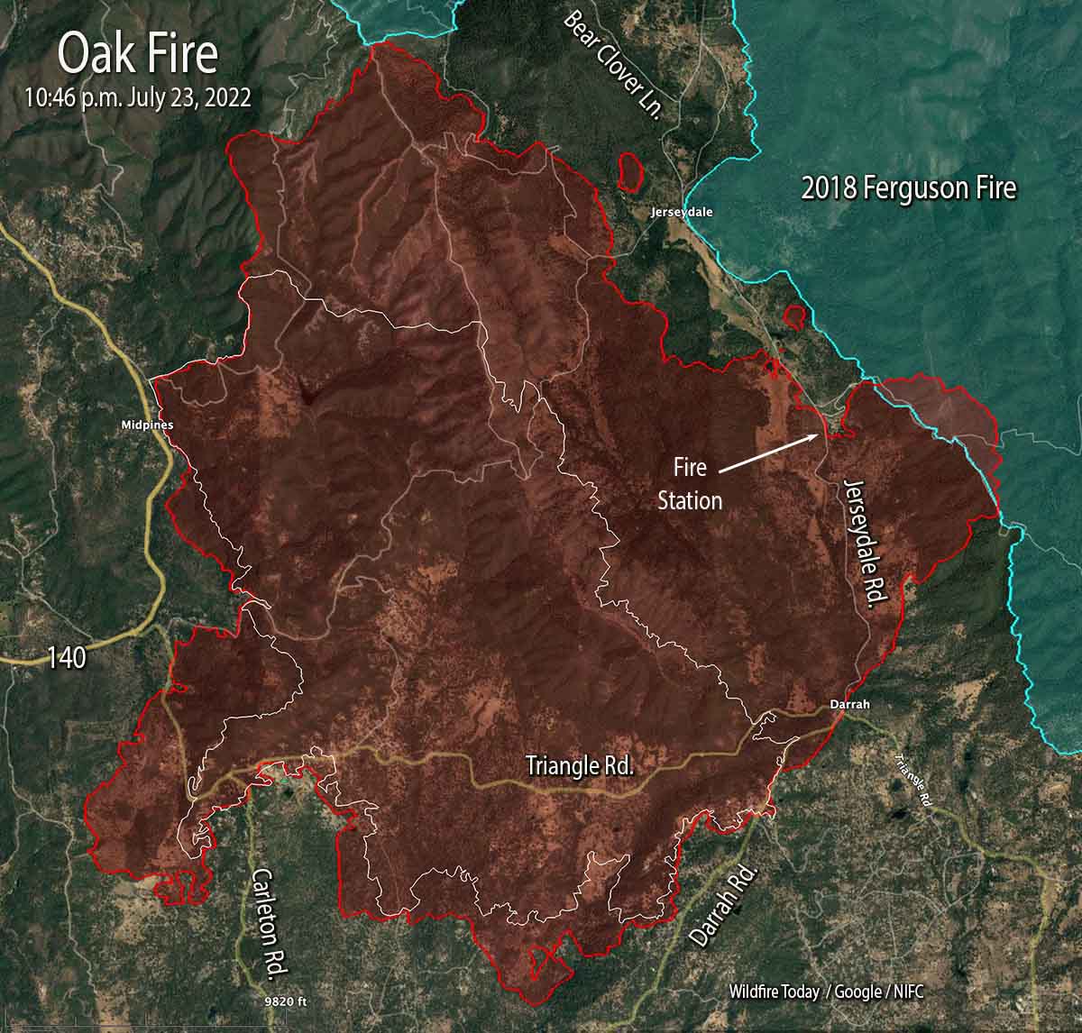
Oak Fire map. The red line was the perimeter at 10:46 p.m. PDT July 23, 2022. The white line was the perimeter at 4 a.m. July 23.
The Oak Fire two miles northeast of Mariposa, California was active on all sides Saturday and into the night. Most of the overnight movement was on the east side which saw the largest growth, spreading for one to two miles east and northeast, crossing Jerseydale road and surrounding a fire station on the road. It moved into the footprint of the Ferguson Fire which burned more than 96,000 acres four years ago.
When the fire was mapped at 10:46 p.m. Saturday night it was spreading toward Bear Clover Lane north of Jerseydale. It was six miles from Yosemite National Park, with the burn scar from the Ferguson Fire in between.
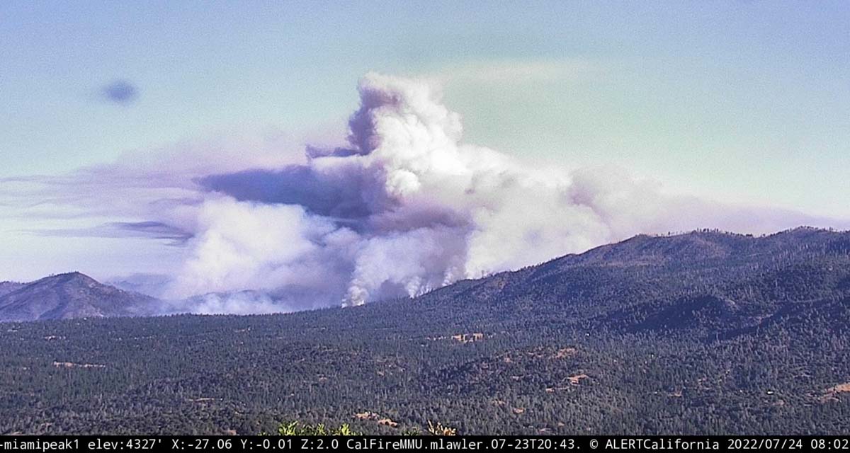
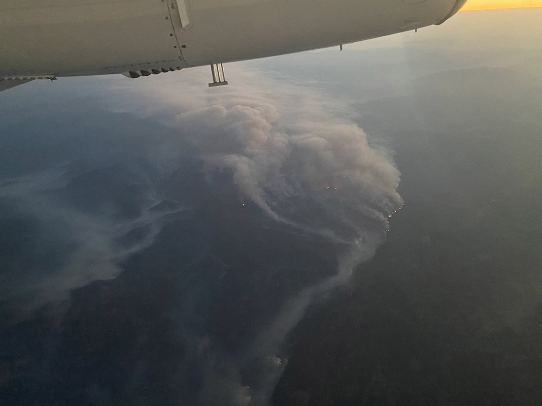
As you can see in the photo below, at 8 a.m. Sunday it was already creating a large plume of smoke.
Oak Fire, as seen from Miami Peak, looking northwest at 802 a.m. July 24, 2022.
CAL FIRE reported Sunday morning at 7 a.m. it had burned 14,281 acres since it started Friday afternoon. The number of structures destroyed remained at 10.
Oak Fire vicinity map. The red line was the perimeter at 10:46 p.m. PDT July 23, 2022. The white line was the perimeter at 4 a.m. July 23.
On the south, it crossed Triangle Road then reached and crossed in some places Darrah Road.
“The fire is moving quickly. This fire was throwing embers out in front of itself for up to 2 miles yesterday,” Daniel Patterson, a spokesman for the Sierra National Forest said Saturday. “These are exceptional fire conditions.”
Oak Fire 3-D map, east side, 10:46 p.m. PDT July 23, 2022.
As of the Saturday night mapping flight the west side has remained east of Highway 140 in the Midpines area.
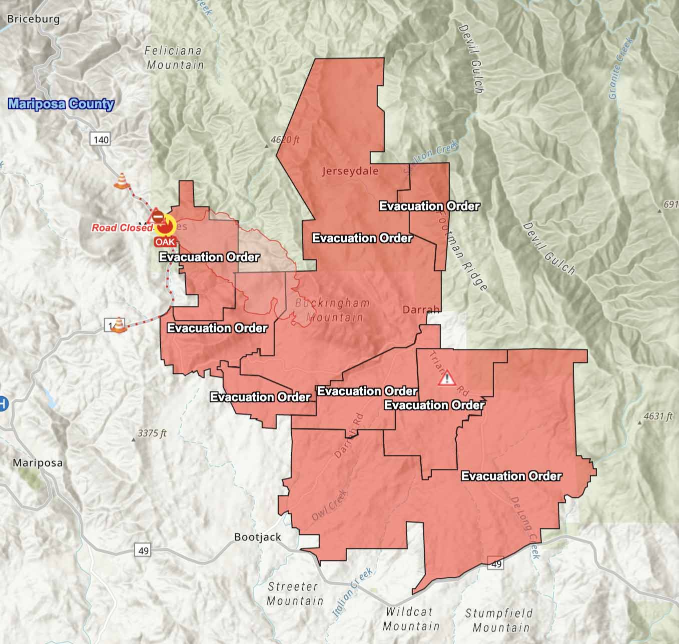
Evacuations are in effect. Mariposa County maintains a map online showing the affected areas.
Resources assigned include 17 helicopters, 225 fire engines, 58 dozers, 23 water tenders, and 51 hand crews for a total of 2,093 personnel.
Oak Fire, at dawn, July 24, 2022. Courtney Aviation.
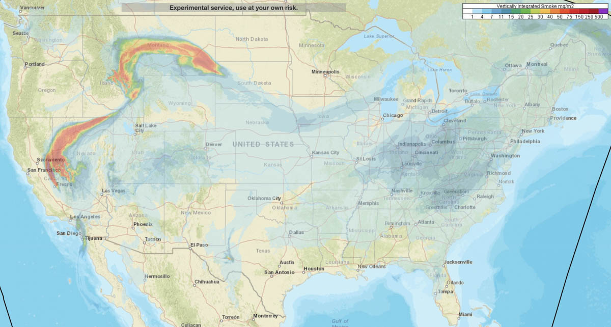
Smoke forecast for the United States at 7 a.m. MDT July 24, 2022. NOAA.
NOAA has produced a forecast for the distribution of vertically integrated wildfire smoke at 7 a.m. MDT Sunday July 24. Locations to be hit the hardest are areas in Northern California, Northern Nevada, Eastern Idaho, and Montana.
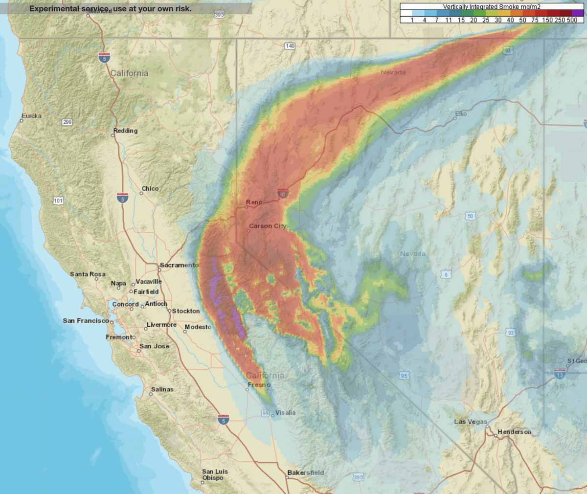
Smoke forecast for Northern California and Nevada at 7 a.m. MDT July 24, 2022.
Most of the 5,000 acres of growth was on the west and east sides
12:12 p.m. MDT July 23, 2022
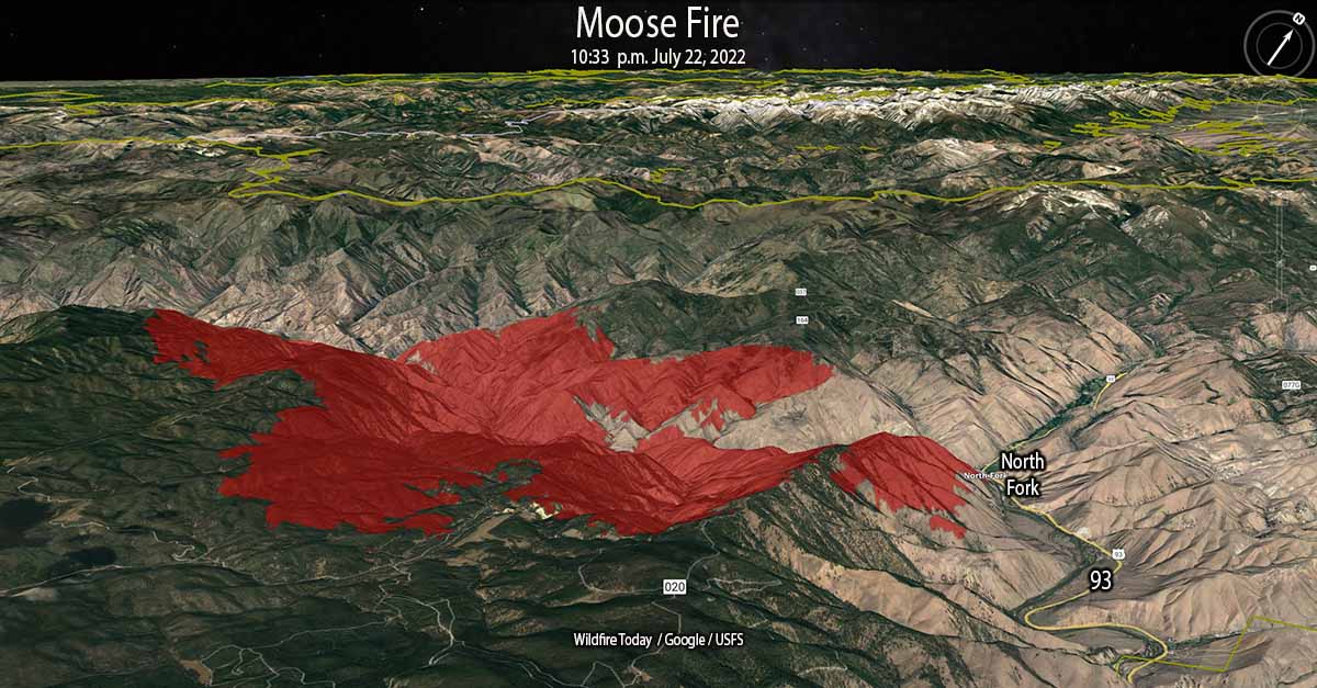
Moose Fire 3-D map looking northwest at 10:33 p.m. July 22, 2022.
Most of the 5,000 acres of growth of the Moose Fire in eastern Idaho Friday was on the west and east sides, spreading for about a mile to the east and west. Friday night the fire burned actively, spreading west as far as Kayak Camp. In the North Fork area it reached the west bank of the Salmon River. Two miles of the east flank are on the steep slopes west of and above US Highway 93.
Friday’s Red Flag weather conditions increased fire activity along the top of Napoleon Ridge. North of the Salmon River, firefighters succeeded in holding fire line built during the last several days.
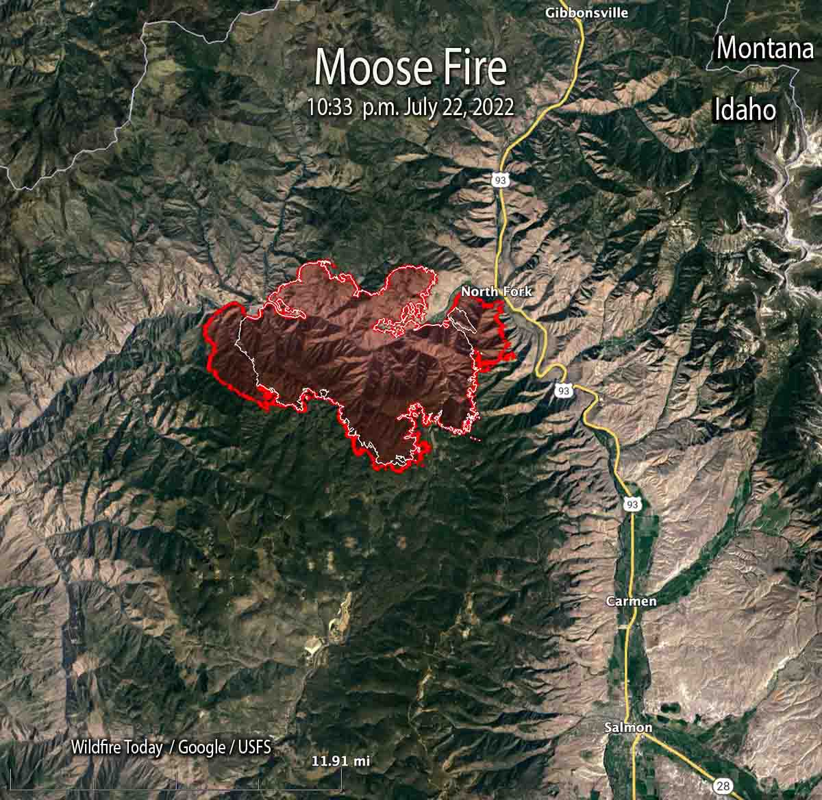
At 10:33 p.m. Friday it was mapped at 28,839 acres. At that time it was 12 miles northwest of Salmon, Idaho and 10 miles west of the Idaho/Montana border.
Map of the Moose Fire. The red line was the perimeter at 10:33 p.m. July 22, 2022. The white line was the perimeter 24 hours before.
Two pilots were killed Thursday July 21 when their Chinook helicopter crashed into the Salmon River while working on the fire. They were identified as Thomas Hayes, 41, of Post Falls, Idaho, and Jared Bird, 36, of Anchorage, Alaska. The National Transportation Safety Board will conduct an investigation.
A spokesperson for the Salmon Challis National Forest said the cause of the fire is undetermined.
Moose Fire 3-D map looking east at 10:33 p.m. July 22, 2022.
On Saturday firefighters will be holding and improving line around the north end of the fire and protecting structures along Salmon River Road and Highway 93. On the southeast side, crews and heavy equipment will work on building an indirect line along Diamond Creek Road from the Highway 93 corridor up into Five Corners.
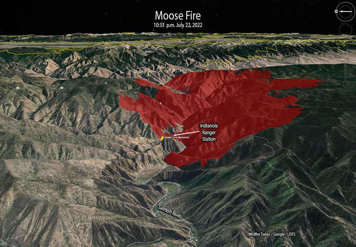
At the site of the Indianola Ranger Station along the Salmon River (see map above) there is a memorial to two firefighters who were killed while working on the Cramer Fire July 22, 2003 — Jeff Allen and Shane Heath, members of the Indianola Helitack Crew. More information HERE and HERE.
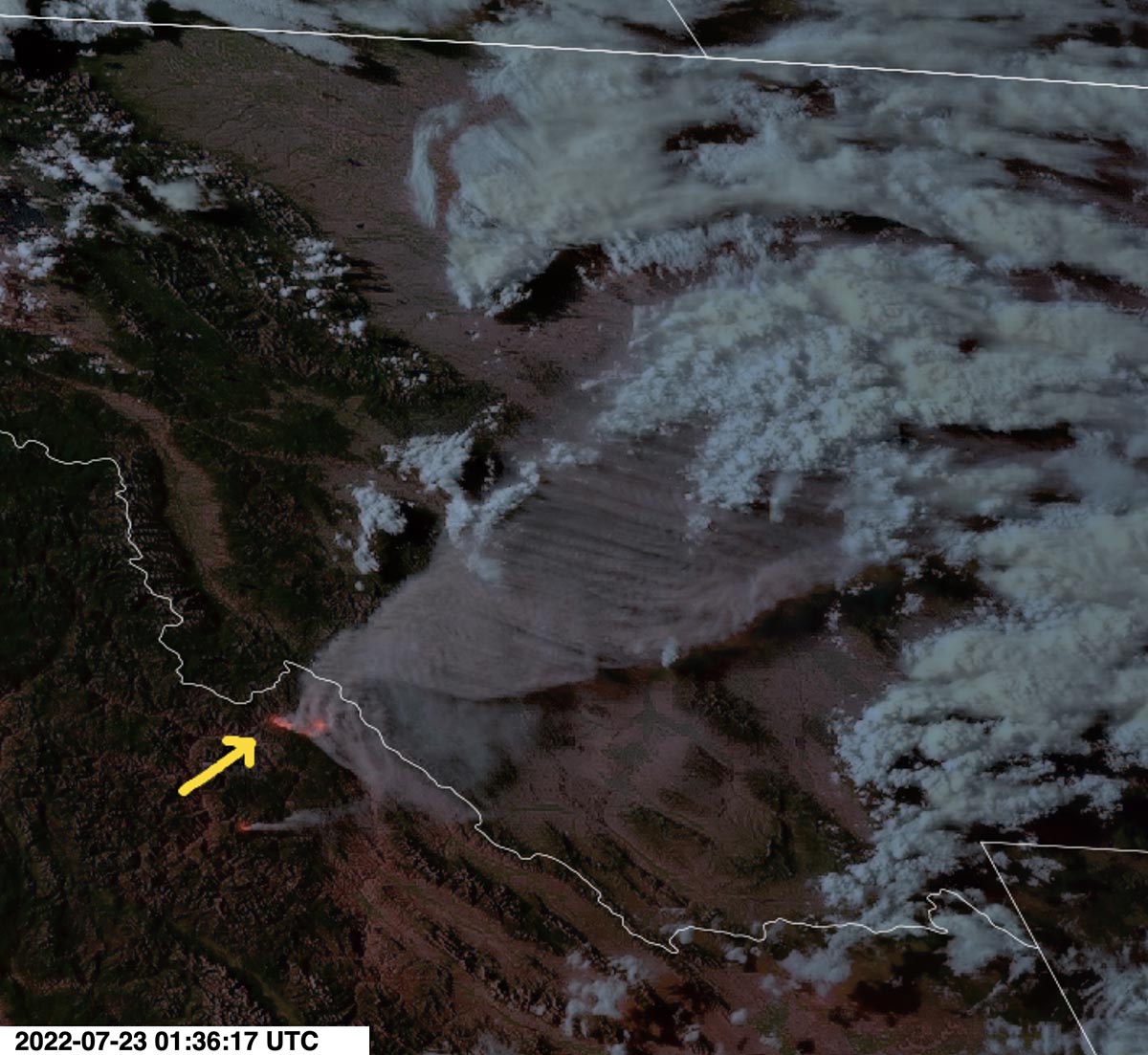
Smoke produced by the Moose Fire in eastern Idaho, as seen from the GOES 17 satellite at 7:36 MDT July 22, 2022.
Weather conditions are expected to moderate Saturday with quieter winds, however it will still be hot and dry for several days.
The Oak Fire has spread to the east quite significantly, crossing Jerseydale Road about two miles south of Jerseydale in the vicinity of Wild Dove Lane.
To see all articles on Wildfire Today about the Oak Fire, including the most recent, click HERE.
That puts it less than a mile west of the footprint of the very large Ferguson Fire which burned more than 96,000 acres in 2018. It was caused by a hot catalytic converter on a vehicle that parked in dry grass July 13, 2018 along Highway 140 near the Savage Trading Post.
The Oak Fire is exhibiting extreme fire behavior, igniting spot fires far ahead of the main fire.
CAL FIRE announced that at 6:45 p.m. it had burned 11,900 acres.
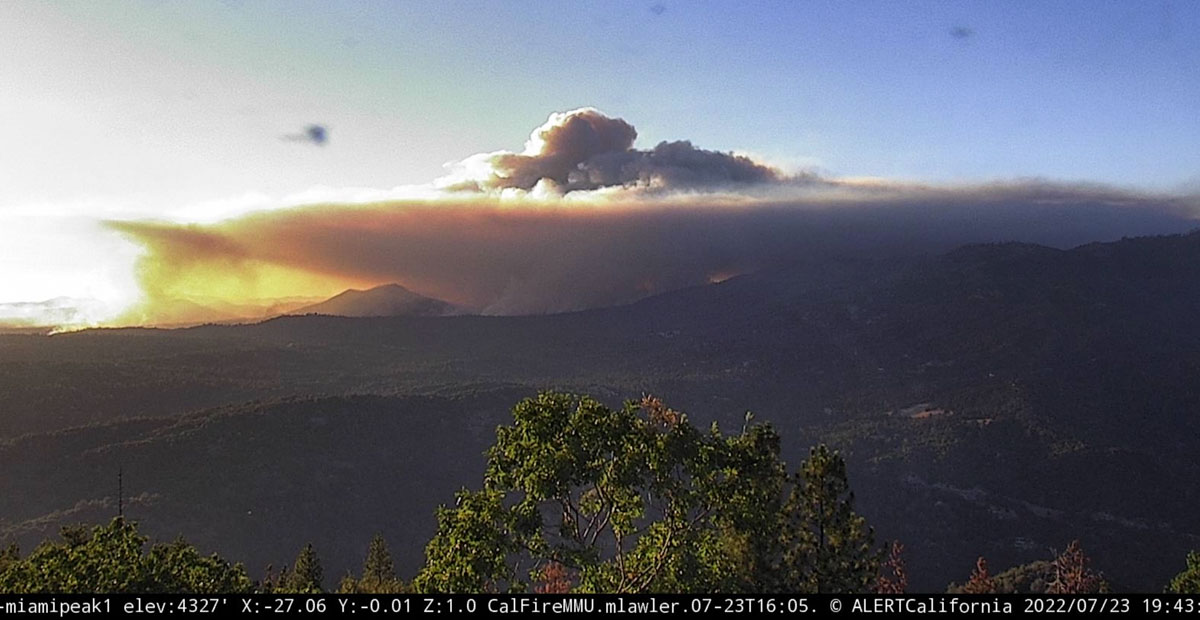
Oak Fire, as seen from Miami Peak, looking northwest at 7:43 p.m. July 23, 2022.
Updated 5:00 p.m. PDT july 23, 2022
Oak Fire, looking northwest from Miami Peak at 4:57 p.m. July 23, 2022.
At approximately 4:20 p.m. Air Attack reported that the latest mapping of the Oak Fire showed had grown to 11,500 acres.
Updated 12:58 p.m. PDT July 23, 2022
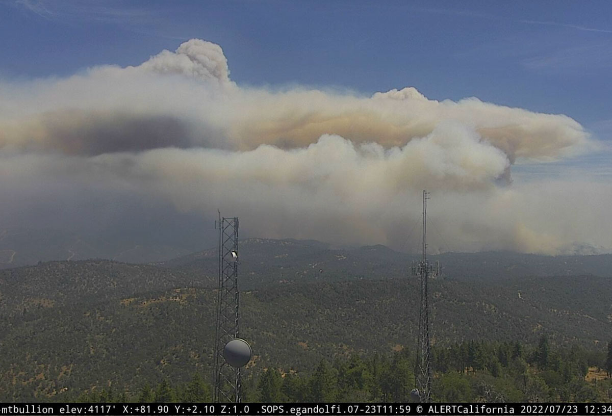
Oak Fire, looking east from Mt. Bullion, 12:34 p.m. July 23, 2022. AlertWildfire.
At 11:15 a.m. Saturday the Oak Fire was mapped by Air Attack at 9,100 acres.
CAL FIRE confirms 10 structures have been destroyed. That number will likely increase.
Updated at 8:35 a.m. PDT July 23, 2022
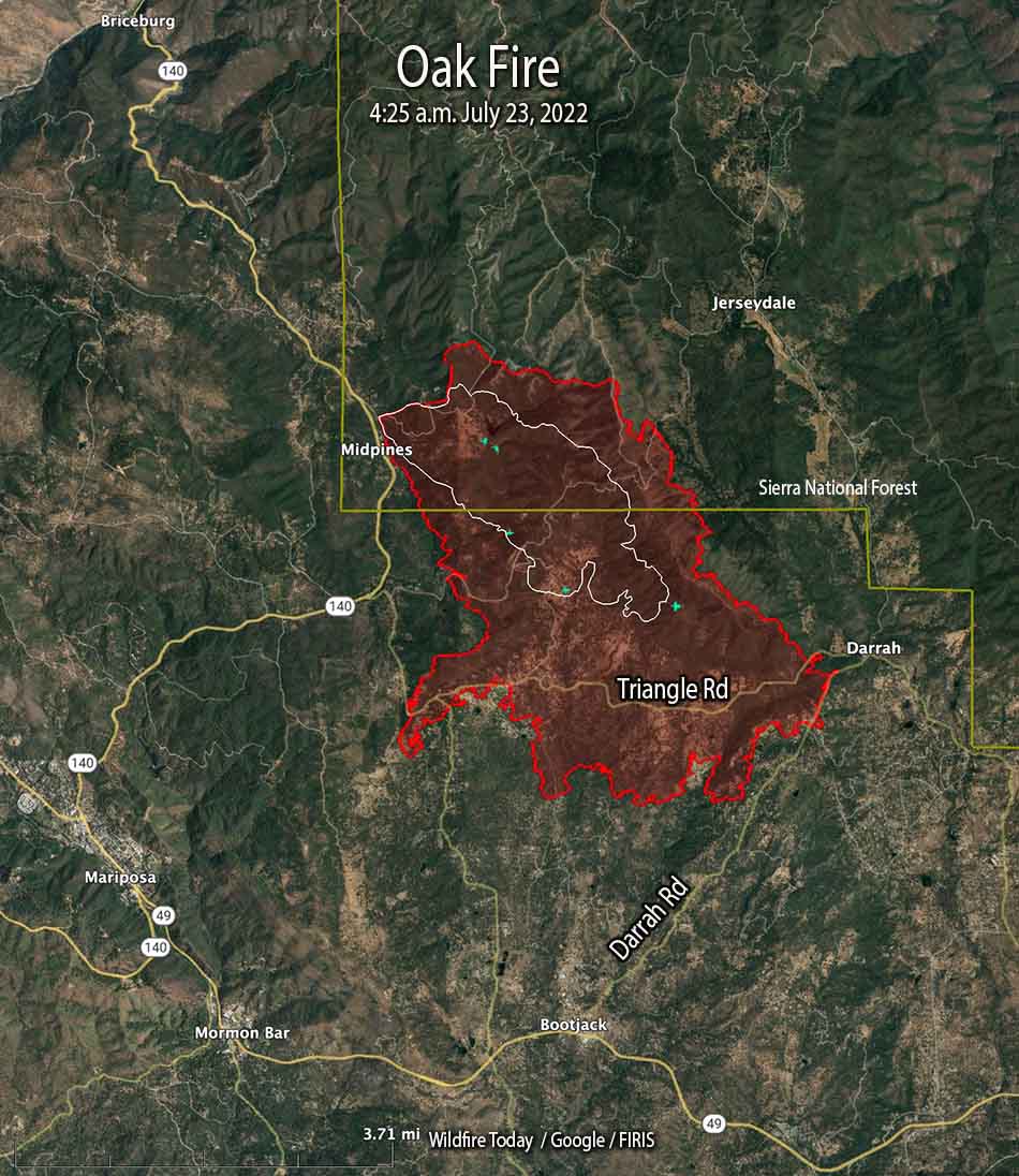
Oak Fire map, the red line was the perimeter at 4:25 a.m. July 23, 2022. The white line was the perimeter at 5:09 p.m. July 22.
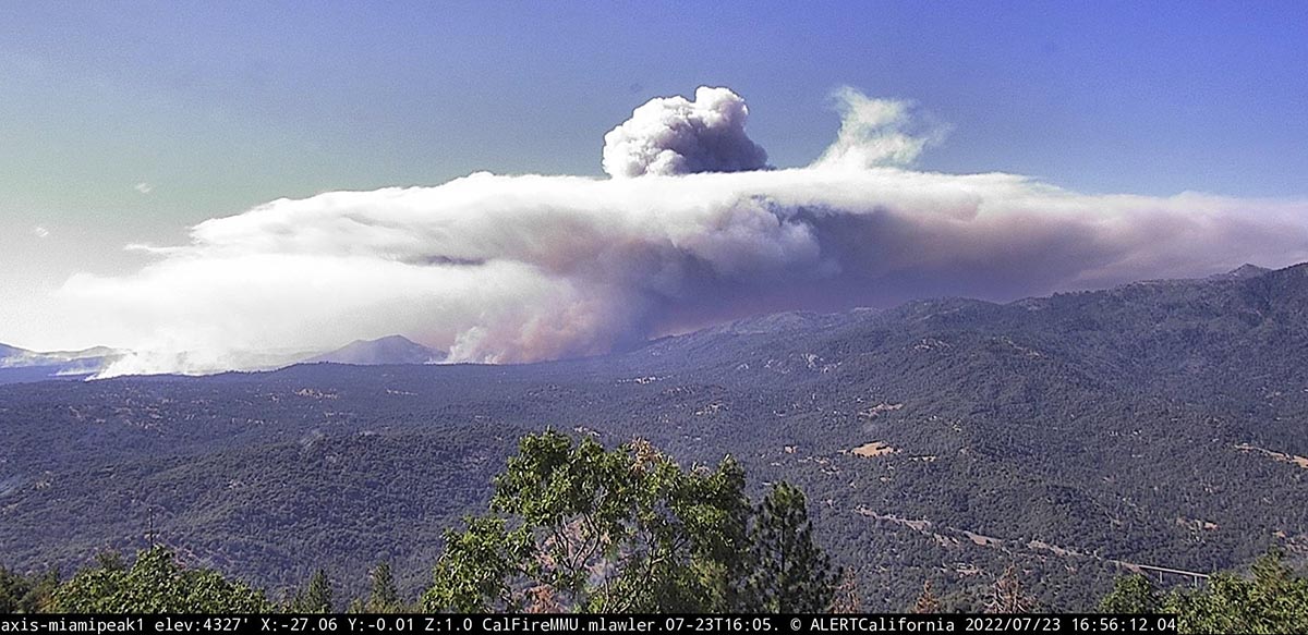
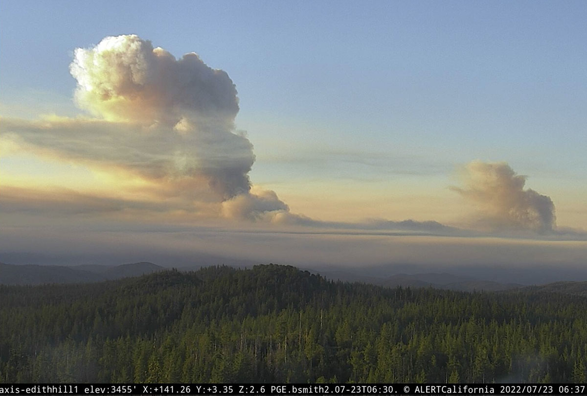
The Oak Fire at Midpines, California was active throughout much of Friday night, growing by about 2,200 acres between 10 p.m. and 4:25 a.m. Saturday when it was mapped by FIRIS at 6,555 acres. Half an hour after sunrise it was putting up two smoke columns that were quite some distance apart, with one of them creating enough energy to be capped by a pyrocumulus cloud.
Two smoke columns on the Oak Fire are seen soon after dawn, looking southeast from Edith Hill at 6:37 a.m. July 23, 2022.
Just to be clear — wildfires normally lay down at night, providing an opportunity for firefighters to move in closer and put in direct fireline. It is not common for a fire to be burning so actively soon after dawn that it is creating multiple smoke columns, especially a pyrocumulus column.
The Mariposa County Sheriff has ordered evacuations as far south as Highway 49 and east to Jerseydale. Their map is available online. As we wrote earlier, this is a dangerous fire.
The Oak Fire is spreading rapidly. When it was mapped at 4:25 a.m. Saturday it had spread south across Triangle Road and reached Darrah Road. At that time it was about a half mile west of the community of Darrah. Firefighters were planning a burning operation between Triangle Road and Darrah Road west of the town.
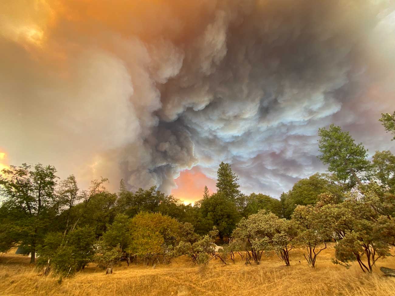
Oak Fire, Lush Meadows subdivision, Friday afternoon July 22, 2022. Credit: Chad Anderson.
Weather
The spot weather forecast for the area predicts hot and dry conditions to persist into next week. Winds will be generally light, except becoming gusty in the afternoons. On Saturday, mostly sunny skies, 90 to 94 degrees, 9 to 13 percent relative humidity, and 6 to 12 mph ridgetop winds from the south to southwest gusting to 20 mph in the afternoon. Saturday night will see poor humidity recovery, 26 to 31 percent, with very light winds. For Sunday, 10 to 14 percent RH with afternoon ridgetop winds out of the west at 4 to 8 mph.
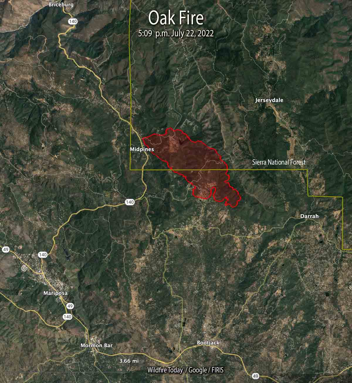
10:36 p.m. PDT July 22, 2022
Oak Fire map at 5:09 p.m. July 22, 2022. The fire is growing rapidly and has doubled in size since this data was collected.
The Oak Fire that started Friday afternoon in Central California has been growing rapidly in Mariposa County. The County Sheriff has ordered evacuations for several areas east and southeast of Midpines. At 10 p.m. Friday it was about 4 miles northeast of Mariposa.
Evacuation Map, Oak Fire, posted by the Mariposa County Sheriff at 10:21 PDT July 22, 2022. This is a dynamic situation and the evacuation status and map may only be current only for a short while.
This is a dangerous fire. Residents should not hesitate to evacuate if there is any doubt about their safety.
At 5:09 p.m. it was mapped at 1,745 acres; at about 10 p.m. CAL FIRE reported it had grown to 4,350 acres.
Oak Fire, looking east at 8:08 p.m. July 22, 2022.
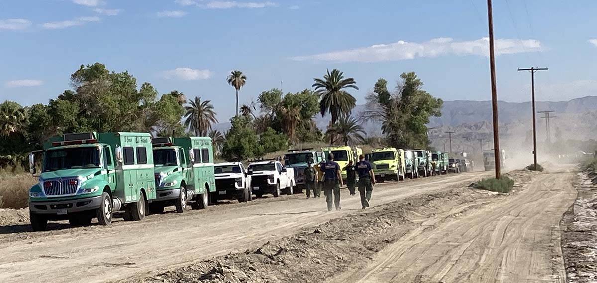
Staging area, Grant Fire, near the Salton Sea in Riverside County, California June 22, 2022. BLM photo.
This weekend we are continuing an occasional weekend feature we started a few weeks ago. This post can serve as the beginning of an open thread where our readers can talk about issues that we have, or have not, gotten into yet. This is literally an off-topic thread. You have the floor.
The usual rules about commenting apply. And remember, no personal attacks or politics, please.
Let’s enjoy a wide-ranging conversation!
(Oh, and send us pics of staging areas — date, location, and photographer’s name would be nice.)