Once thought to be basically immortal, sequoias are now dying in droves

(Quote from Kyle Dickman’s article in Outside)

firefighter giant sequoia Washburn Fire Yosemite National Park
A firefighter in Yosemite National Park scrapes material away from a giant sequoia during the Washburn Fire in July 2022. NPS photo by Garrett Dickman.

Kyle Dickman has written a must-read article for Outside magazine about how the largest trees on Earth which can live for more than 3,000 years, are being increasingly affected in recent years by fire. It was published this week at the magazine and covers how  management of the giant sequoias in Yosemite National Park and other areas in the Sierras has affected the vulnerability of the huge mature specimens in the groves.

Mr. Dickman is a former member of the Tahoe Interagency Hotshot Crew and spent five seasons fighting fires. He wrote the book “On the Burning Edge: A fateful Fire and the Men Who Fought It“, which is about the Granite Mountain Hotshots and the fire where all but one of them died in 2013, the Yarnell Hill Fire.

The article frequently mentions Mr. Dickman’s brother, Garrett, who is the Forest Ecologist at Yosemite and has been heavily involved in managing and attempting to save the giant sequoias. The piece is extremely well written. You can read the entire article at Outside.

Below are a few excerpts:


“What nature’s doing isn’t natural,”  [said Joe Suarez, the Arrowhead Hotshots superintendent]

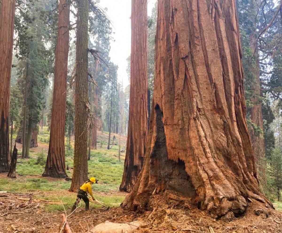
Garrett [Dickman] and Christy Brigham, the director of science at Sequoia and Kings Canyon National Park, are standing in front of an outhouse that firefighters saved from the Castle Fire, sitting in the patchy shade of a 2,000-year-old dead tree that they did not. Firefighters protect life and property before all else—even holes to shit in, so long as they have walls around them. Listening to the two compare notes on their jobs makes clear that the fate of giant sequoias is almost entirely in the hands of a few middle managers, working at a few select parks, who navigate arcane environmental laws and a financing system cobbled together with public grants. If sequoia death is a product of American gridlock, sequoia survival will happen because of the tenacity of a few individuals.

The current drought is more intense than any experienced in California in 1,200 years.

“These next couple of years could be bad in ways we haven’t experienced yet,” Garrett says. The Park Service knows what’s coming. After 60 years trying to walk backward by managing their lands to be what conservationist Starker Leopold, who devised the agency’s guiding philosophy from the late 1960s until 2021, called “vignettes of primitive America,” the Park Service has changed course to officially recognize that park managers must intervene in ways considered antithetical to their mission two years earlier. The new policy asks the public to open its mind to everything from mechanical thinning to very limited logging. “We saw how it goes when you don’t do anything,” Christy says. “It goes terribly. It goes thousands of 2,000 year old trees burned up in an instant.”

“We don’t get to have nice things anymore,” Garrett says.”

“The Clean Water Act. The National Environmental Policy Act. The National Historic Preservation Act. The Threatened and Endangered Species Act. Fantastic laws all of them,” Christy says. “But they were built at a time when the main threat was people doing bad things—logging, mining. Now the main threat is inaction. Bureaucracy is slow. Wildfire is fast. And bureaucracy needs to get a hell of a lot faster if we want to persist and not lose everything we’ve got left.”

The remaining battle on Yosemite National Park’s Washburn Fire is on the east side

A very steep area with large rock outcroppings

10:06 a.m. PDT July 15, 2022

Washburn Fire 3-D map 10:10 p.m. PDT July 14, 2022
The red line on the 3-D map (looking southeast) was the perimeter of the Washburn Fire at 10:10 p.m. PDT July 14, 2022. The white line was the perimeter about 48 hours before.

The challenge remaining on the 4,759-acre Washburn Fire in Yosemite National Park is to corral the east side where it has spread into the Sierra National Forest, a very steep area with large rock outcroppings.

They have established three helispots on the north side of the South Fork of the Merced River and one on the south side that could be used for inserting firefighters. Their plan is to insert a small group of hotshots on the east side of the fire south of the river at Helispot 5 on the map below, being pointed to by Planning Operations Section Chief Matt Ahern. Their task will be to construct fire line on that corner, west of Iron Creek, working downhill and uphill to anchor and stabilize the fire at that point. This would then enable hotshot crews to “come off the top”, said Mr. Ahern.

Washburn Fire briefing, by Ops PSC Matt Ahern, July 15, 2022
Washburn Fire briefing by Operations Planning Section Chief Matt Ahern, July 15, 2022. He is pointing to Helispot 5 where a small group of Hotshots will be inserted to establish an anchor point on the northeast corner of the fire above the South Fork of the Merced River.

Contingency fire lines are being constructed some distance from the fire on the south and east sides in case extreme weather drives the fire in those directions.

The Buck Cabin east of the fire built in 1931, was recently rehabilitated at great expense. The wood shake shingle roof was replaced with — another wood shake shingle roof. Since it is very, very vulnerable to fire, and in a roadless area, firefighters will be flown by helicopter to the area, rappel to the ground, and wrap it in foil-based structure wrap.

Most of the fire edge near the Mariposa Grove of giant sequoias has been secured with fire line, Mr. Ahern said.

Washburn Fire map 10:10 p.m. PDT July 14, 2022
The red line on the map was the perimeter of the Washburn Fire at 10:10 p.m. PDT July 14, 2022. The white line was the perimeter about 48 hours before.

“Overall the incident is in a very good place,” said Mr. Ahern. “We still have a tremendous amount of work and a heavy commitment of hotshot crews and aerial resources to pinch off Iron Creek.”

The infrared video below shot at 10:39 p.m. July 14 shows the east side of the fire.

Grant Fire burns 74 acres southeast of Sacramento

Grant Fire, July 14, 2022. CAL FIRE
Grant Fire, July 14, 2022. CAL FIRE.

8:09 a.m. PDT July 15, 2022

Thursday afternoon firefighters stopped the spread of the Grant Fire after it burned 74 acres about 15 miles southeast of Sacramento, California. The blaze was reported at 5:44 p.m. 4 miles northwest of Rancho Murieta just west of Scott Road. CAL FIRE reports that one outbuilding was destroyed.

Firefighters worked throughout Thursday night patrolling and building containment lines. On Friday they will continue mopping up hot spots and smoldering areas within oak groves and strengthening containment lines.

Grant Fire map July 14, 2022.

Peter Fire near Anderson, CA prompts evacuations

Updated 9:44 p.m. PDT July 14, 2022

Peter Fire map, 6 p.m. July 14, 2022
Peter Fire map, 6 p.m. July 14, 2022. FIRIS.

CAL FIRE reported at 9 p.m. that the Peter Fire at Anderson, CA has destroyed 12 structures and has burned 304 acres. They did not specify how many of the structures were residences.

Firefighting resources assigned include 51 engines, 18 water tenders, 15 hand crews, 6 helicopters, and 7 dozers for a total of 497 personnel.

The Shasta County Sheriff’s Office has evacuation information. At 8 p.m. they posted the following:

UPDATE. All residents in homes east of the intersection of Third Street and Missouri Lane to Highway 273 can return to their homes. All roads connected to Spring Gulch Road west of Missouri Lane remain under evacuation order. Residences on Diamond Street west of Franklin remain under an evacuation order. The evacuation warning for all streets off Parallel Road and Jacqueline Street remain in effect.


Updated at 6:01 p.m. PDT July 14, 2022

Air Attack reports that the Peter Fire at Anderson, California is looking good, and they have a retardant line around most of the perimeter. They are keeping two air tankers to be able to pick up spot fires as they occur. The other tankers have been released, including a Very Large Air Tanker.

The fire is believed to have started from a structure fire that spread into the vegetation. At 6 p.m. there were no engines available to work on a burning structure, so helicopters were dropping water on it.

The Shasta County Sheriff’s Department has evacuation information on their Facebook page.


Updated at 5:25 p.m. PDT July 14, 2022

Peter Fire map
Peter Fire mapped by FIRIS at approximately 4:11 p.m. PDT July 14, 2022.

FIRIS mapped the Peter Fire at 248 acres at approximately 4:11 p.m. PDT Thursday. At 5:25 p.m. it was mapped again at 303 acres.

Peter Fire photo
Peter Fire, looking southeast from the Falcon camera at 5:11 p.m. PDT July 14, 2022. AlertWildfire.

4:58 p.m. PDT July 14, 2022

air tankers Peter Fire at 4:16 p.m. July 14, 2022
Aircraft near the Peter Fire at 4:16 p.m. July 14, 2022. FlightRadar24

A new fire south of Redding, California is prompting evacuations west of Anderson. The Peter Fire was reported at around 3 p.m. PDT and at last report had burned at least 50 acres. It is four miles south-southwest of the Redding Air Attack base which results in quick turnarounds for air tankers reloading with retardant.

Firefighters on scene have reported 30 structures that are threatened and several times have requested additional engines and aircraft. There are reports that the fire has reached some structures and air tankers are making retardant drops near them attempting to lessen the damage. At least half a dozen air tankers are on scene or en route.

The evacuation center is at West Valley High School, 3805 Happy V Road, Cottonwood, CA.

Peter Fire Anderson California 5:23 p.m. PDT July 14, 2022
Peter Fire, looking southeast from the Falcon camera at 4:23 p.m. PDT July 14, 2022. AlertWildfire.

Weather

Since the fire started the Howard Street weather station in Anderson has recorded 88 degrees, 13 percent relative humidity, and 10 to 12 mph winds out of the south and south-southeast gusting to 12 mph. The forecast for the rest of the afternoon calls for winds increasing to 14 mph out of the south, then slowing after sunset to 3 mph for the rest of the night. The nighttime humidity should rise to 52 percent then on Friday drop to 10 percent in the afternoon with 6 mph winds out of the south.

County Commissioners urge USFS to conduct EIS on 50,000-acre fuel treatment project in New Mexico

Santa Fe National Forest

Map Santa Fe Mountains Landscape Resiliency Project
Map of the Santa Fe Mountains Landscape Resiliency Project.

The Board of County Commissioners of Santa Fe County in New Mexico passed a resolution Tuesday urging the U.S. Forest Service and the Santa Fe National Forest to conduct a full Environmental Impact Statement (EIS) for a planned very large fuel management project.

The 50,566-acre Santa Fe Mountains Landscape Resiliency Project would involve prescribed fire and vegetation thinning treatments on 36,680 acres to improve ecosystem resilience by reducing stand density, stand continuity, and stand homogeneity and increase a diverse forest structure at a landscape scale. At least 750 acres would be treated each year with manual or mechanical vegetation thinning and no more than 4,000 acres per year would be treated by the use of prescribed fire during a 15- to 20-year project time frame.

The Forest Service went through the much less complicated Environmental Assessment (EA) process, which included the draft EA, public outreach, and accepting comments, then issued the Finding of No Significant Impact (FONSI) which they feel enables the implementation of the project.

But after three prescribed burning projects on the Santa Fe National Forest got out of control since 2018 and had to be converted to wildfires, some of the locals are worried about future projects on the forest.

The current 341,735-acre Calf Canyon / Hermits Peak Fire is the result of two prescribed fires that escaped control earlier this year on the Santa Fe National Forest. One was a broadcast burn that crossed control lines during strong winds. The other originated from slash piles that were ignited in late January that continued burning for months. In mid-April one or more of those piles became very active during strong winds and merged with the other escaped fire on April 22. The fire has destroyed at least 400 homes, forced up to 18,000 people to evacuate their properties, and cost more than $248 million in firefighting expenses.

In 2018 another pile burning project on the Santa Fe escaped months after it was ignited and had to be converted to a wildfire. A Facilitated Learning Analysis found that “communication” and “prescribed fire preparation and risk” were common themes.

The Commissioners voted unanimously Tuesday for the USFS to go through the EIS procedure, which takes much longer than an EA and can be a costly process.

“Unacceptable risks are taken by personnel conducting planned burns because they are pressured to accomplish the mission,” the resolution states. “An EIS is appropriate because the EA … did not disclose or analyze the significant impacts to resources of an escaped intentional burn resulting from global heating and increased fine fuels.”

The resolution Requests the USFS cease all prescribed burns on the proposed project area “until the greater understanding and concomitant risk reduction provided by these reviews is in place.”

The USFS documents regarding the project can be found here.

Thanks and a tip of the hat go out to Sarah.

Sir Charles assists in campaign to get firefighting helicopters for Lake Tahoe

Charles Barkley, Tahoe helicopters
Charles Barkley and Tahoe Douglas Fire Chief Scott Lindgren are helping to spread the word about a campaign to acquire two firefighting helicopters for the Lake Tahoe area. Still image from South Lake Tahoe Now video.

NBA legend Charles Barkley is helping the Tahoe Douglas Fire Department spread the word about a campaign to acquire two firefighting helicopters for the Lake Tahoe area in Northern California, which according to the Fire Chief is devoid of permanent helicopter coverage.

From the description and amount of funds being sought, it appears their hope is to purchase two Sikorsky S-70i Firehawk helicopters capable of carrying up to 1,000 gallons of water and also capable of responding to medical incidents with a paramedic and full advanced life support equipment. In order to have continuous coverage with a helicopter, you need at least two in a fleet to account for scheduled and unexpected maintenance.

The article below by Paula Peterson was first published on SouthTahoeNow.com.


STATELINE, Nev. – Charles Barkley remembers the American Century Championship in July 2007 very well. He and the other celebrities had arrived at Lake Tahoe to golf in the annual tournament at Edgewood Tahoe, but that year it was different.

The devastating Angora Fire started off of North Upper Truckee Road on June 24, and before it was done on July 2 it had burned through 3,100 acres, destroyed 242 residences and 67 commercial structures, damaged 35 other homes, and engaged 2,180 firefighters.

Barkley said they couldn’t “yuck” it up at celebrity golf across the lake and have fun while nearby residents were dealing with such a catastrophe. He asked NBC if he could take a camera crew into the fire-damaged area.

“I came up here 15 years ago and saw catastrophic damage. It broke my heart. I’d actually never seen fire damage before,” said Barkley.

He donated $190,000 to recovery efforts for residents over the following two years and treated firefighters and their spouses to dinner at Harrahs Tahoe.

At Edgewood Tahoe Saturday, during the 33rd annual American Century Championship, Tahoe Douglas Fire Chief Scott Lindgren held a press conference with Barkley to highlight his agency’s Operation Save Lake Tahoe.

Lindgren has said there is a giant hole in the middle of the Sierra without firefighting helicopter coverage, and that is the Lake Tahoe Basin and surrounding mountains. He wants to change that with a $60 million plan that would bring two helicopters, a station, and training to not only Douglas County, but to the whole Lake Tahoe Basin and surrounding Sierra.

Fundraising efforts have been underway for months, but much more needs to be raised.

“So anything you can do to help, please help these guys get their helicopter, please, because, hey, we can’t let nothing happen to this place,” said Barkley.

“We can’t let it happen again,” Barkley said of the Angora Fire.

For more information or to donate, visit https://tahoefire.org/helicopter.