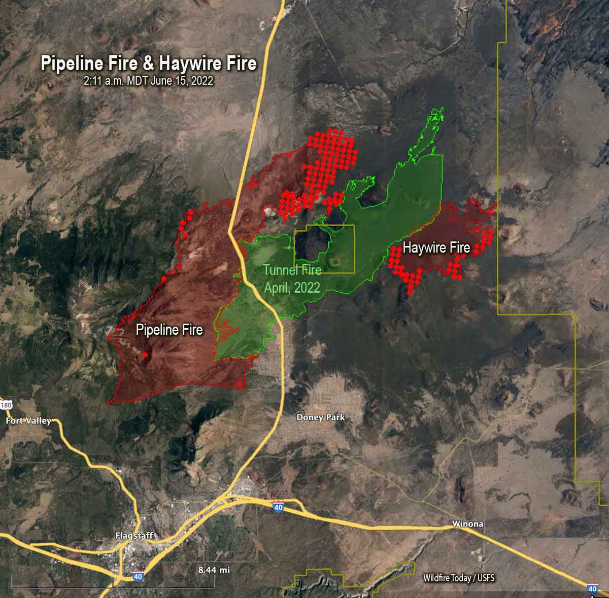
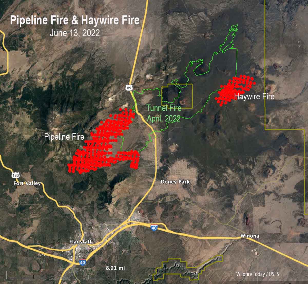
Map of the Pipeline and Haywire Fires. The red dots represent heat detected by a satellite at 2:11 a.m. MDT June 15, 2022. The red line was the perimeter at 11:15 p.m. MDT June 14, 2022.
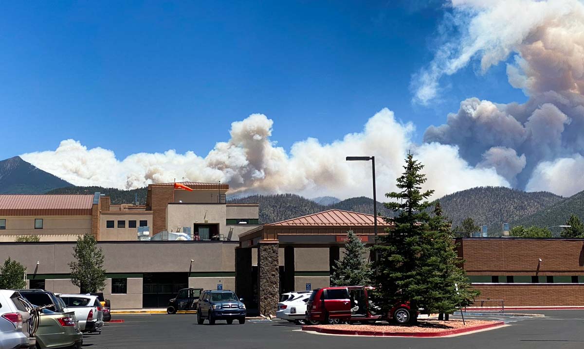
The Pipeline Fire six miles north of Flagstaff, Arizona was active Tuesday on the northeast side, north of Sunset Crater Volcano National Monument. The rest of the blaze was relatively quiet.
The Haywire Fire was active on the south side Tuesday.
A mapping flight Tuesday night put the Pipeline Fire at about 22,000 acres, and the Haywire Fire at about 5,000 acres.
With added resources that came into Flagstaff over the last day, it put more boots on the ground. With the winds lower, it brought out the air support. On the Pipeline Fire Tuesday were two DC-10 aircraft, at least three large aircraft, and multiple helicopters and scout planes. Air support bombarded the fire through most of the day. On the Haywire Fire, fire crews saw the biggest problems. Stephen Fillmore from the Type 2 fire team from California working the fire tells KAFF News, Tuesday was a good day for fire crews. He says late in the day “the wind picked up and changed direction a little bit, which took the fire into some new fuels” which created a lot of smoke. Air attack used the rest of daylight to work on that fire.
A man was arrested Sunday in connection with starting the Pipeline Fire. He told officers he had ignited toilet paper after using it and placed it under a rock Saturday, and that he tried to put out the fire with his sleeping bag. His camp was 80 yards from where the fire started according to court documents. The probable cause of the Haywire Fire is lightning, but that still needs to be confirmed by investigators.
Fire crews on the Route Fire in Southern California, 4:40 p.m. Sept. 11, 2021, about five minutes before they were nearly entrapped. Photo by one of the firefighters.
I have never seen anything like this. Over the past few months numerous politicians have been motivated and nationally recognizable media outlets have assigned reporters to dig through the opaque barriers established by the US Forest Service, Bureau of Land Management, and the National Park Service to expose the worsening working conditions of wildland firefighters. Even though Congress passed a law requiring improvements in several areas, the bureaucratic morass of inaction driven by the indecisiveness of leaders has led many of them to abandon all hope, and quit.
Reasons cited by current and former firefighters include very low pay, long hours, too much time away from home, too little time with families, limited opportunities for career growth, costs of housing, inadequate mental health support, and the temporary and sometimes life-altering physical injuries experienced by these tactical athletes. This has led to severe difficulties in hiring and retaining firefighters, resulting a large number of vacant positions at all levels.
One of the latest well-researched pieces about the decline of working conditions for federal firefighters was published today, written by Alex Wigglesworth, a staff writer for the Los Angeles Times. It is titled, “Hellish fires, low pay, trauma: California’s Forest Service firefighters face a morale crisis.”
In addition to documenting and elaborating on the issues above, their research found:
“Only 62% of federal firefighter positions [in California] are filled, according to a source within the agency. Before 2020, nearly all firefighter positions across the nation would typically be filled at this time of year.”
“Roughly a third of all Forest Service fire engines in California are on five-day staffing, meaning there aren’t enough crew members to operate them seven days a week.”
“Another 13% of engines are “down staffed” — essentially parked due to lack of firefighters.”
The reporter mentioned Chris Mariano who was a GS-6 Squad Boss on the Truckee Hotshots in Northern California until April 7, 2022 when he resigned. Wildfire Today published a letter he wrote at the time. He said drafting it was difficult — the best part of his life was working as a hotshot on the Tahoe National Forest:
“I prospered — I was all in,” he wrote. “I wanted nothing more than to be a hotshot, to be a leader, to care for the land and to be of service. While the sense of purpose and camaraderie remain, I now feel hypocritical to recruit or encourage crew members to work for an agency that is failing to support its fire management programs and thus the public.”
“The agency is failing its firefighters on so many levels. Classification, pay, work life balance, mental health, presumptive disease coverage, and injury/fatality support. There are efforts to correct some of these issues but for many it is too little too late…We are losing people at a terrifying rate at a time when wildfires burn longer, hotter, more frequently, and with devastating severity.”
Four new designs remain within survival limits longer
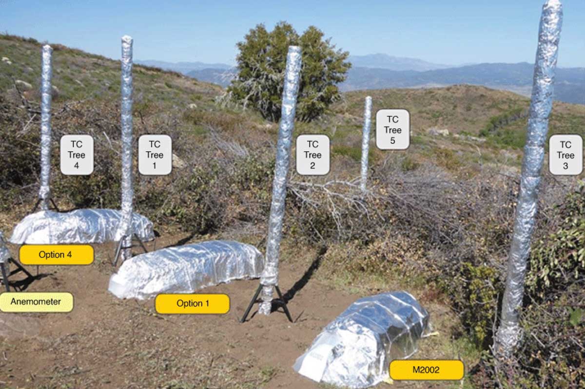
Layout of field equipment. TC, thermocouple trees; shelters in random plot location, and anemometer. Photo was from Mount Palomar Test 1.
By Laura Oleniacz, North Carolina State University
North Carolina State University researchers found that four new designs for shelters to protect firefighters trapped in wildfires could increase the survival time inside the shelters compared with the current industry standard. In lab simulations of wildfire burn-overs — where a wildfire sweeps over a group of trapped firefighters or equipment — temperatures inside the shelters remained within survival limits for longer, and the shelters took longer to break open.
Researchers hope their findings from the lab, as well as from field tests conducted across North America, could spur the development of new, better shelters. In addition, they hope the findings will inform new standards for shelter design and testing.
“For the wildland firefighter, deploying a shelter is the last thing they want to do — it’s the final resort, the last line of defense,” said study co-author Roger Barker, the Burlington Distinguished Professor of Textile Technology at NC State and the director of the Textile Protection and Comfort Center (TPACC). “While there’s no such thing as ‘fire-proof,’ what we’re trying to do is to buy more time. We were able to demonstrate our shelters could increase the time to failure — time that could be critical for survival.”
One problem with the industry standard shelter is that the aluminum outer layer will melt in contact with direct flame.
“In light of the failure mechanisms of shelters that we observed during wildland fires, we thought we could develop better shelters that provide enhanced protection by incorporating an inner heat-blocking barrier and additional thermal insulation into the construction,” said the study’s lead author Joseph Roise, professor of forestry and environmental resources at NC State. “We know we can make a better shelter.”
With that goal in mind, the researchers designed two leading prototypes and two lighter versions weighing less than 5 pounds. They added insulating materials, and experimented with different seam designs to keep them from falling apart.
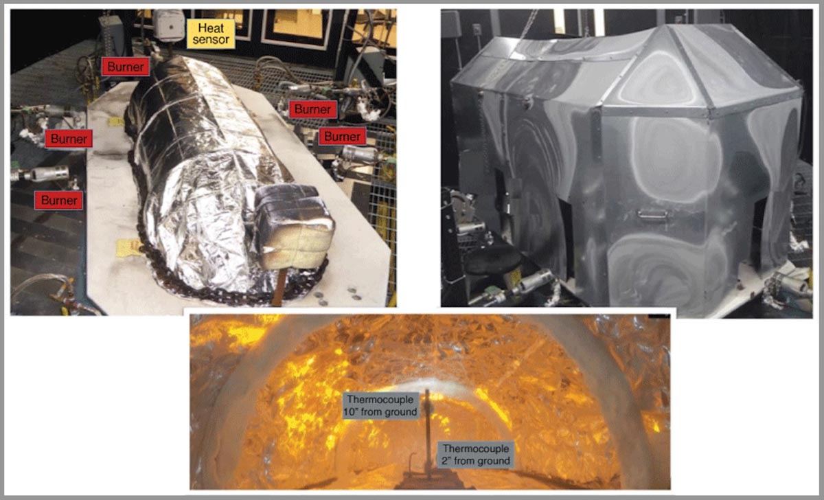
Photo of PyroDome: top left shows the shelter layout, burners and heat sensors; top right is the dome to concentrate flames and turbulence; bottom is an interior view of the shelter during test, showing small thermocouple tree.
In the TPACC lab, researchers tested the designs against the industry standard in a test chamber called the PyroDome Turbulent Flame Fire Shelter Test System. They blasted the shelters with direct flame from propane burners for 60 seconds, and measured how long it took the temperature at the floor of the shelters to reach 302 degrees Fahrenheit, the temperature threshold for survival. They also set up cameras inside PyroDome to see when the inner layer of the shelters would break open.
All of the prototypes had improved survival metrics compared to the standard, which reached the survival limit in less than 40 seconds. Meanwhile, the temperature in one of their designs was nowhere near the survival limit temperature at 60 seconds.
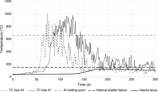
Internal and external temperature profiles (Prototype 4, field test 1). For every test and for every shelter, there is a temperature profile. The upper horizontal line is the melting point of aluminium. Summing the time of both TC1 and TC4 above that line gives us ∑t660. The lower solid line is the internal shelter temperature 5.1 cm (2 in) from ground. The difference between peak and ambient temperature gives us ΔT. R660 = ΔT[∑t660]−1 is the insulation performance index.The researchers also tested the shelters’ performance in variety of conditions in controlled burns in Canada, California, North Carolina and South Dakota. However, they found the field tests were not reliable enough to draw statistically significant conclusions because of wind, fuel and fire conditions.
“We went all over North America to find different fire conditions that would give different types of fire exposures,” Barker said. “What we found is there is so much variability in the field test, confirming how useful it was for us to have PyroDome.”
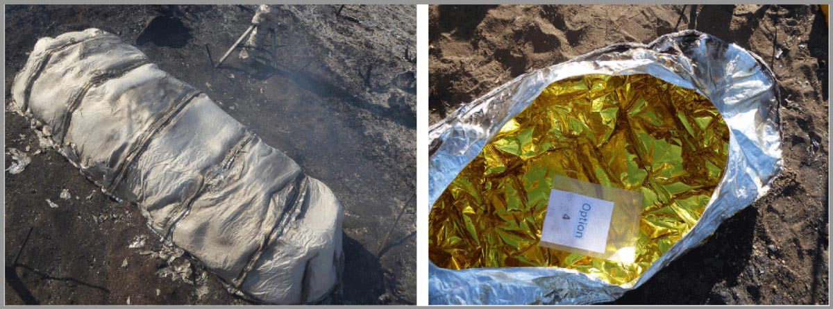
Photo of Prototype 4 in Field Test 1. Left shows 99% exterior damage and right shows interior free of damage.
The two tests in southern California had the best burn conditions, and researchers saw one of their prototypes performed well in a burn-over. In a test in South Dakota, researchers witnessed shelter failures when grass roots caught fire to spread under the walls inside the shelter. That underscored the importance of fully clearing the area around the shelter, and even scraping down underneath them to remove all organic material.
“If you have a sample of two, you can’t make any statistical comparisons,” Roise said. “But we did see that after the test in California, one of our best-performing prototypes got the full brunt of the fire. It was totally burned on the outside, but the inside was undamaged.”
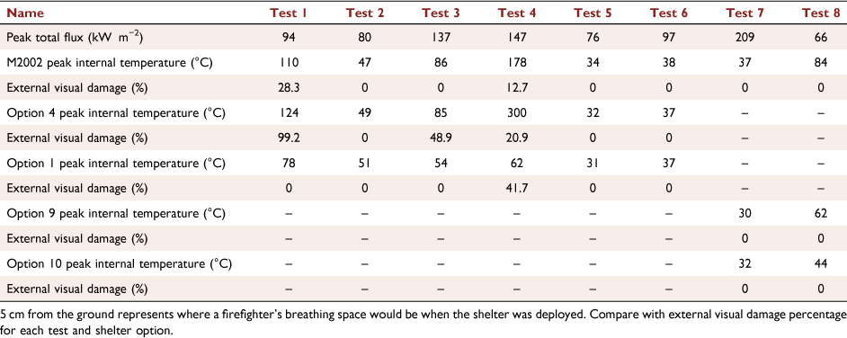
Summary of peak internal fire shelter temperatures at 5cm (2 in).
The new findings could give manufacturers and people developing these shelters a new target to shoot for in terms of both how to test them and minimal performance requirements, according to Barker.
The study, “Field and full-scale laboratory testing of prototype wildland fire shelters,” was published online in the International Journal of Wildland Fire. In addition to Barker and Roise, other authors include John Williams, a former research assistant in forestry and environmental resources at NC State, and John Morton-Aslanis, a research assistant in TPACC. The study was funded by the DHS FEMA Assistance to Firefighters Grant Program.
The Rancho Fire in Rancho Tehama in Northern California has destroyed 10 structures and damaged 4 others, the California Department of Forestry and Fire Suppression said Monday night.
It was mapped Monday afternoon at 255 acres with a 17-acre spot fire out ahead. Tuesday morning at 8 a.m. it had grown to about 700 acres, CAL FIRE reported.
Evacuations are in effect and 158 structures are threatened.
Rancho Fire, 8:04 p.m. PDT, June 13, 2022.
The fire is 14 miles southwest of Red Bluff and 14 miles northwest of Corning.
Rancho Fire map, 12:07 a.m.. June 14, 2022
The aerial video below was shot at 6:20 p.m. PDT June 13, 2022. After that, the size more than doubled.
OCFA’s FIRIS Intel 12 on the Rancho Incident, Tehama County. The main fire is mapped at 255 acres with a 17.5 acre spot fire at the head of the fire. pic.twitter.com/lJOwdKA3ej
Map showing the perimeters of the Pipeline & Haywire Fires at 9:30 p.m. MDT June 13, 2022. The red dots represent heat detected by a satellite at 1:41 a.m. MDT June 14, 2022.
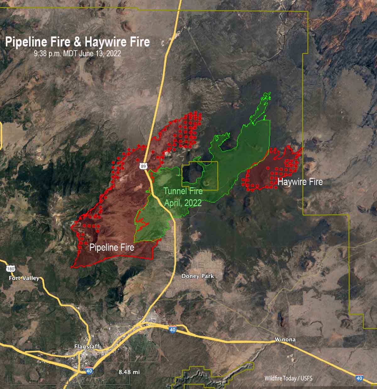
A mapping flight at 9:38 MDT Monday night determined that the Pipeline Fire had grown to 20,178 acres and the Haywire Fire was 4,051 acres. Both blazes are within the Coconino National Forest, but at that time the Haywire Fire had reached the boundary and may spread outside the Forest. The Double Fire appears to have merged with the Haywire Fire.
The fires are burning in timber and grass. Some of the areas near the Sunset Crater Volcano National Monument have volcanic soils with little vegetation between patches of shrubs, grass, and trees. The elevation ranges from 6,000 to 10,000 feet, with the higher elevations on the west side of the Pipeline fire having a much greater density of timber as evidenced by the photo below and the extreme fire behavior Monday when flames at least 400 feet high were seen in videos.
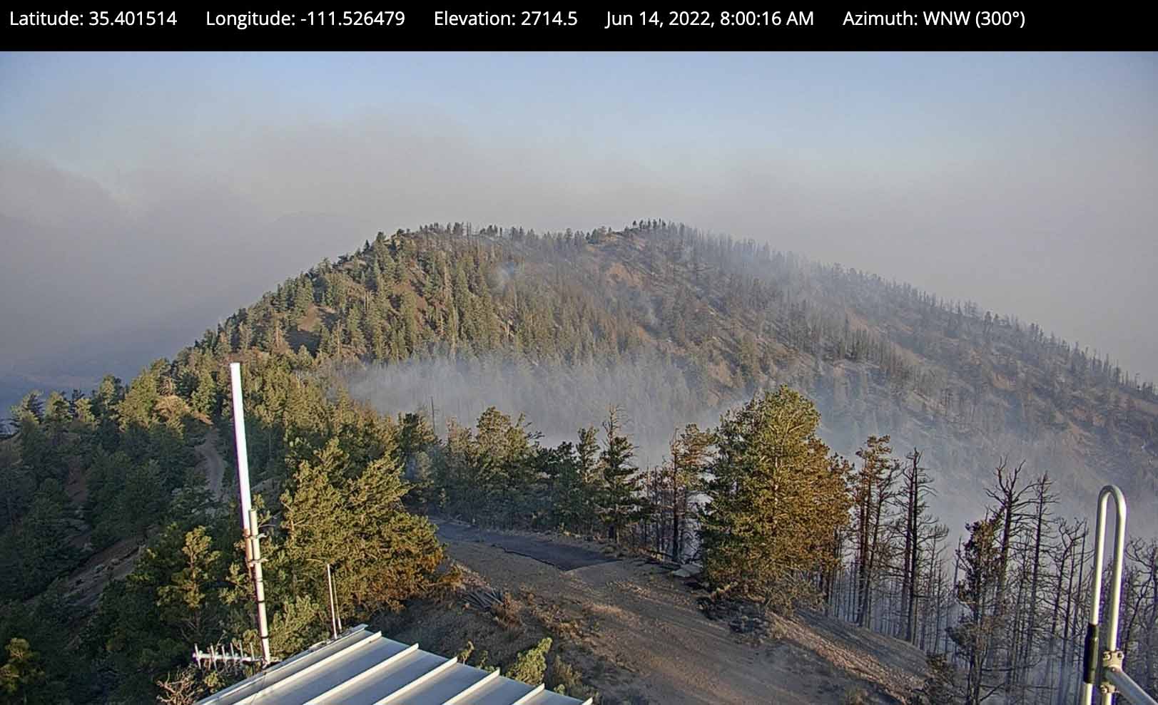
View from the OLeary camera, north of the National Monument at 8 am. June 14, 2022.
In April of this year the 19,000-acre Tunnel Fire burned across the National Monument. The photo below was taken in 2017.
Sunset Crater Volcano National Monument, May 20, 2017.
Updated at 11:00 p.m. MDT June 13, 2022
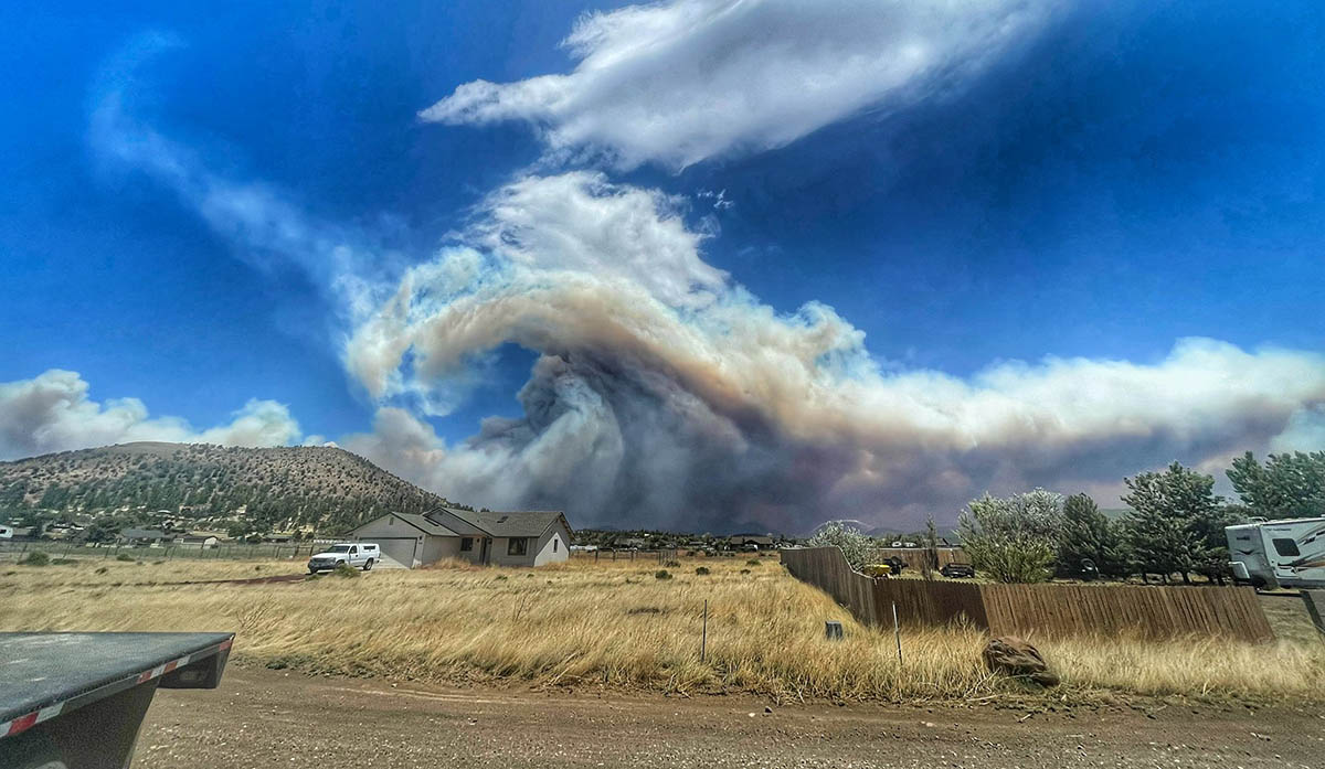
I have seen and been under many smoke columns, but I’ve never seen this on a large fire. Things that come to mind are mountain wave and wind shear. And, GTFO.
Pipeline Fire north of Flagstaff June 13, 2022, by @russdussel
Fire officials said the Pipeline Fire has burned about 6,500 acres.
A man has been arrested Sunday in connection with starting the fire. He told officers he had ignited toilet paper after using it and placed it under a rock Saturday, and that he tried to put out the fire with his sleeping bag. His camp was 80 yards from where the fire started, according to court documents.
This is not the first time a wildfire has been ignited by burning toilet paper. We have eight other articles on Wildfire Today tagged “toilet paper”.
Thanks and a tip of the hat go out to Dick.
Updated at 8:13 p.m. MDT June 13, 2022
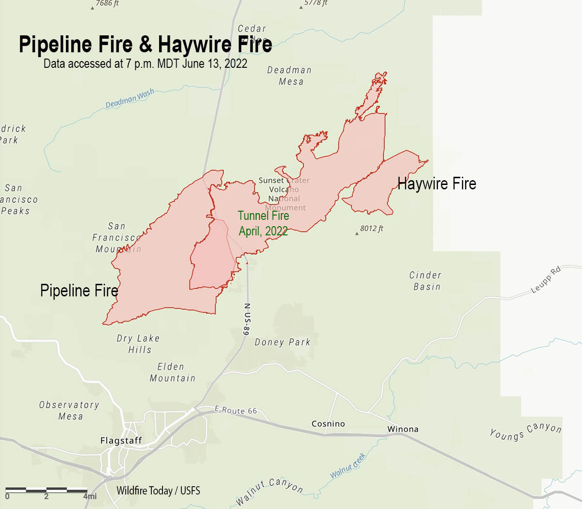
Map of the Pipeline & Haywire Fires. Data accessed at 7 p.m. MDT June 13, 2022. The exact time the data was created on June 13 is unknown.
In a briefing Monday evening fire officials said at least one structure has been destroyed in the three fires burning north and northeast of Flagstaff, Arizona. It appears that the Pipeline, Haywire, and Double Fires have or will soon merge with the footprint from the Tunnel Fire that burned about 19,000 acres north of Flagstaff in April of this year.
The blaze was exhibiting extreme fire behavior Monday afternoon.
Coconino County has established a website with maps showing evacuation status.
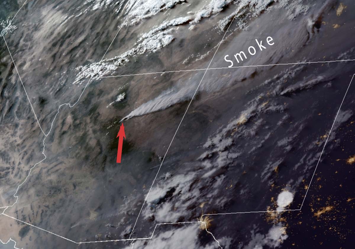
Satellite photo showing smoke from the Pipeline and Haywire Fires at 6:21 p.m. MDT June 13, 2022. The red arrow points to the fires. NOAA.
Monday afternoon the wind near the fire was gusting as high as 49 mph out of the south-southwest while the relative humidity dropped as low as 6 percent. This, and the very dry vegetation, accounts for the extreme fire behavior on Monday.
2:35 p.m. MDT June 13, 2022
Map of the Pipeline Fire ane Haywire Fire, June 13, 2022. The Tunnel Fire, the green perimeter, burned in April, 2022. The red dots represent heat detected by a satellite at 2:49 a.m. MDT June 13, 2022.
Three fires in northern Arizona are spreading rapidly in the Coconino National Forest north and northeast of Flagstaff.
The Pipeline Fire six miles north of the city started Sunday morning June 12. On Monday it has been pushed by winds gusting out of the southwest at 25 to 35 mph as the relative humidity dropped to 10 percent in the afternoon. It has reached the Tunnel Fire that blackened about 19,000 acres in April of this year. Judging from the massive smoke column it appears to be burning around it. Fire officials estimate it has blackened approximately 5,000 acres, but that number is changing hourly.
Pipeline Fire, June 13, 2022, by @RealTaoOfSwan.
Another fire, the Haywire Fire, was was reported Sunday afternoon on the southeast side of the Tunnel Fire perimeter. It is about seven miles northeast of the Pipeline Fire, making it unlikely that it could have begun as a spot fire started by a lofted burning ember. Fire authorities said the probable cause of the 1,600- acre fire is from a lightning strike several days earlier and is expected to merge with the Double Fire.
A third fire was also reported Sunday afternoon about two miles south of the Haywire Fire. The Double Fire has burned about 500 acres according to Forest officials and was likely also caused by lightning.
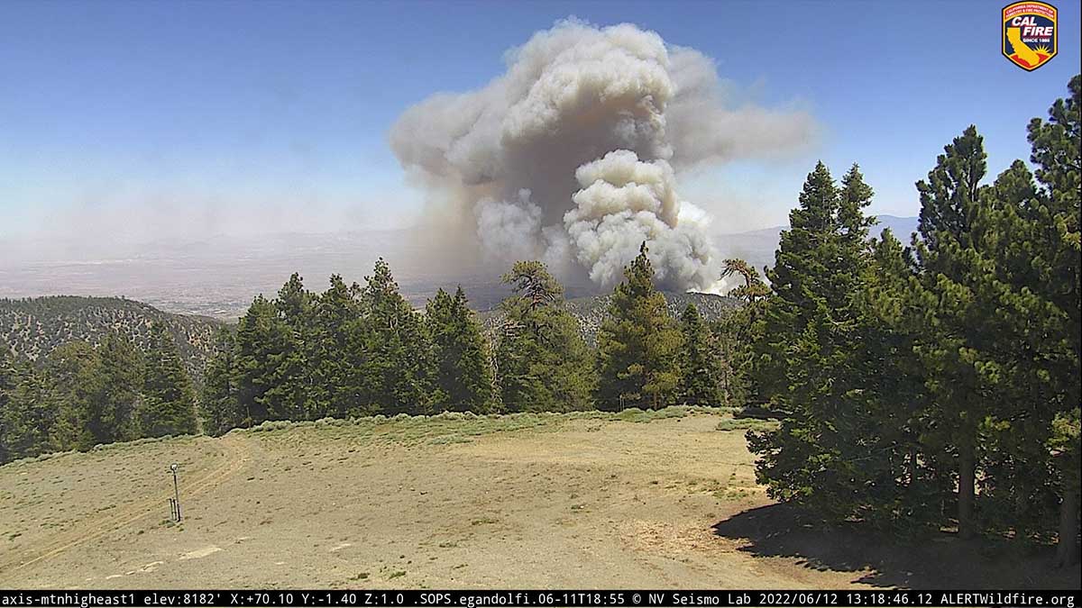
The Sheep Fire just northeast of Wrightwood, California has prompted evacuations of some areas northwest of the community. The San Bernardino County Sheriff’s Office and NIXLE have the details. An evacuation center is at Serrano High School, 9292 Sheep Creek Road, Phelan, CA 92371.
The fire is burning on both sides of Highway 2 and Sunday evening was spreading toward Desert Front Road. Most of the heat detected by a satellite overnight was on the northwest side of the fire.
Smoke over the Sheep Fire at 8:24 a.m. June 13, 2022.
Monday morning the Southern California Geographic Coordination Center said it had been mapped at 939 acres, an increase of 139 acres overnight. It was reported Saturday June 11 at 6:30 p.m.
Sheep Fire, 1:18 p.m. June 12, 2022.
The incident is being managed by the Angeles National Forest, San Bernardino County Fire, and CAL FIRE in unified command.
Sunday afternoon a cell phone outage was reported in the Wrightwood area, and law enforcement was prepared to go door to door if additional evacuations were required.
California Incident Management Team 14 with Incident Commander Watkins will in-brief Monday at 5 p.m.