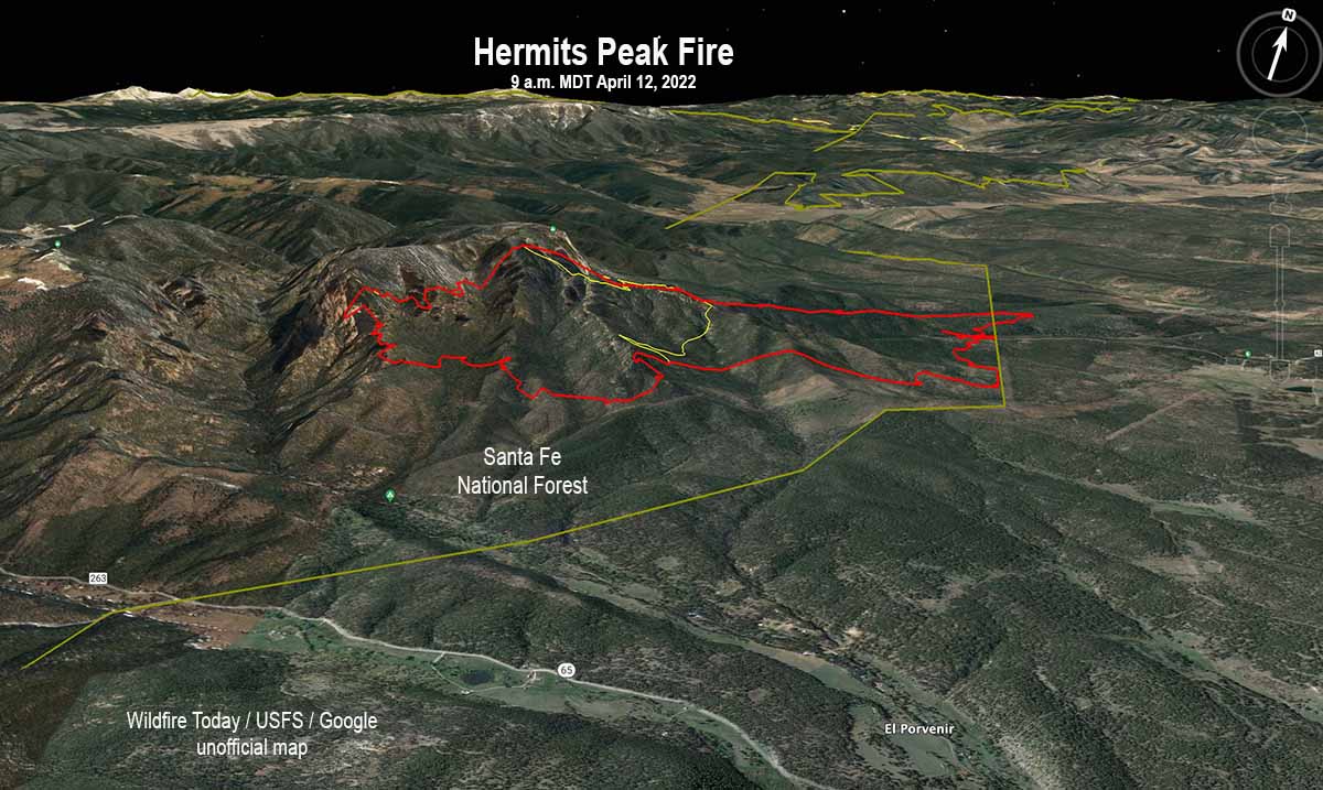
3-D Map of the Hermits Peak Fire at about 9 a.m. April 12, 2022. The yellow line within the fire was the perimeter about 24 hours before.
The Hermits Peak Fire 12 miles northwest of Las Vegas, New Mexico ran to the northeast Monday, moving out of the Santa Fe National Forest onto private land. The Incident Management Team said Monday afternoon it had burned 1,280 acres and a mapping flight that night put it at about 1,600 acres. Satellite data at 3:11 a.m. Tuesday indicated that it continued to spread significantly overnight. At about noon on Tuesday the Incident Management Team said it had burned 1,908 acres.
To see all articles about the Hermits Peak Fire on Wildfire Today, including the most recent, click HERE.
The San Miguel County Sheriff’s Office issued a mandatory evacuation for the communities of San Ignacio, Las Dispensas, Pendaries, Las Tusas, and Canoncito on Monday, April 11. An evacuation shelter is available at the old Memorial Middle School gym located at the corner of Legion and Old National in Las Vegas, NM.
The Incident Management Team reports that 600 structures are threatened and none have been destroyed. Resources assigned include 5 hand crews, 13 fire engines, and 3 helicopters for a total of 244 personnel.
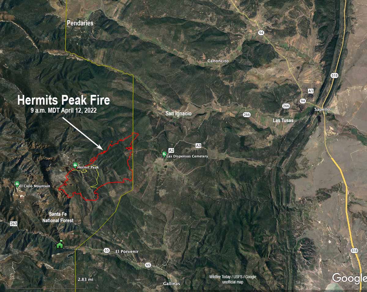
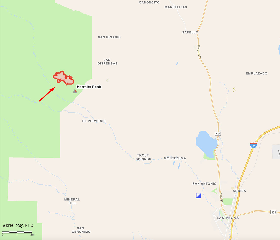
Map of the Hermits Peak Fire. The red line was the approximate perimeter at about 9 a.m. April 12, 2022. The yellow line within the burn was the approximate perimeter early in the morning April 11. The straighter yellow line is the boundary of the Santa Fe National Forest.
The area continues to be under a Red Flag Warning Tuesday and Wednesday. According to the Red Flag Warning the winds will be 30 to 45 mph out of the southwest gusting to 65 mph Tuesday, and 25 to 35 mph from the west with gusts to 40 on Wednesday. The relative humidity will be 10 to 15 percent Tuesday, dropping to 4 to 10 percent Wednesday. The National Weather Service forecast for the fire area agrees. The wind will be very strong Tuesday and Wednesday, and will slow to 10 to 20 mph Thursday through Sunday. The direction will be generally from the west the entire period and the relative humidity will be about 9 percent.
Under these weather conditions on Tuesday and Wednesday firefighting aircraft may not be able to effectively and safely operate, and firefighters can’t take direction on the head of the fire.
The Santa Fe National Forest announced today that a prescribed fire planned for the Santa Fe municipal watershed has been postponed.
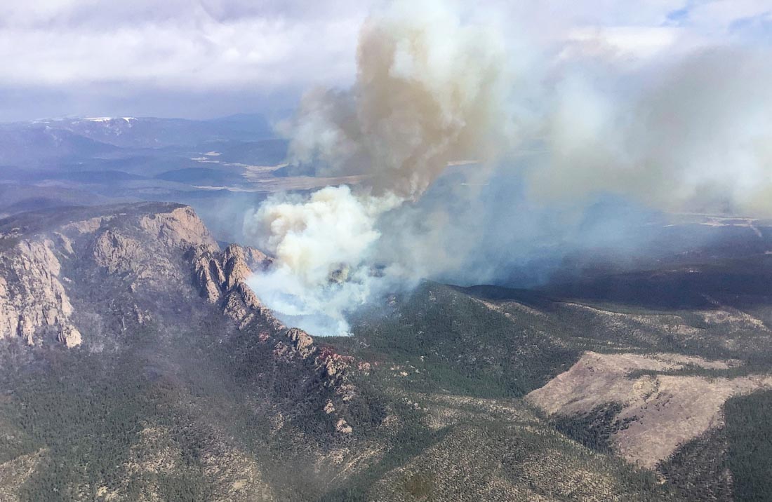
Hermits Peak Fire, April 10, 2022. USFS.
We will update this article as more information becomes available.
Updated at 6:45 p.m. MDT April 11, 2022
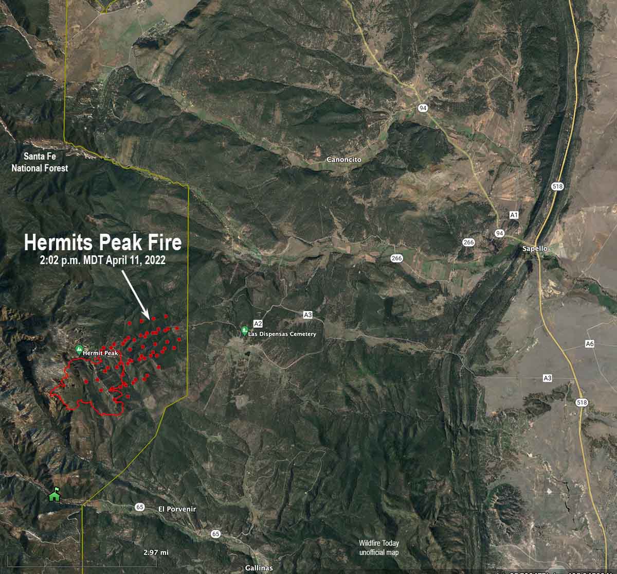
The red dots on the map represent heat detected by satellites on the Hermits Peak Fire at 2:02 p.m. MDT April 11, 2022. The red line was the approximate perimeter early Monday morning.
At 1:30 p.m. Monday, strong winds pushing the Hermit Fire to the northeast prompted the San Miguel County Sheriff’s Office, in coordination with the US Forest Service, to order an immediate full evacuation of Las Dispensas, Pendaries, Las Tusas, San Ignaciao, and a “high alert warning” for the Canoncito area.
At 2:02 p.m. Monday, satellites detected heat from the fire very close to the border of the Santa Fe National Forest as it was spreading to the northeast. If that rate of spread continued it most likely moved out of the National Forest onto private land later in the afternoon.
Darren Krull, Chief of the Elwood Volunteer Fire Department. Nebraska State Patrol photo.
A fire chief was killed in a traffic collision in south-central Nebraska Thursday April 7 at a large wildland fire.
A Ford Expedition, driven by Phelps County Emergency Manager Justin Norris, with passenger Darren Krull, Chief of the Elwood Volunteer Fire Department, was struck head on by a water truck approximately eight miles north of Arapahoe on Highway 283.
The Nebraska State Patrol (NSP) said Chief Krull, 54, of Elwood, was killed at the scene. Norris, 40, of Holdrege, was transported to the hospital in Cambridge with life-threatening injuries. He was transferred to Good Samaritan Hospital in Kearney in stable condition. He was later moved to a hospital in Omaha. Friday morning he was in stable condition.
According to NSP, the driver of the water truck, Andries Van Aswegan, 28, of Arapahoe, was not injured in the crash.
The fire and smoke in the area had created zero-visibility conditions on the roadway at the time of the crash.
The wildfire in Nebraska burned about 30,000 acres. Nebraska Emergency Management Agency
The fire, 30 miles long and 5.5 miles wide, burned at least 30,000 acres, 8 homes, and 48 other structures. It started when strong winds blew a tree into a power line.
Our sincere condolences go out to the family, friends, and co-workers of Chief Krull.
Thanks and a tip of the hat go out to Art, Gerald, Matt, and Tom.
Hermits Peak Fire, the morning of April 10, 2022. USFS photo.
Information released from the Incident Management Team for the Hermits Peak Fire at approximately 1:30 p.m. MDT on Sunday, stated that voluntary evacuations are in effect for three communities:
In coordination with the San Miguel County Sheriff’s Office, voluntary evacuations for the communities of San Ignacio, Las Dispensas and Pendaries have been put in place. Forecasted winds exceeding 60 mph have been predicted for today. Increasing winds each day through next week can cause holding concerns, drier weather is forecasted into next week and a RED FLAG WARNING is in effect for the fire area today until 8 pm.
The Incident Management Teams will continue using full suppression strategy utilizing hand crews and assessing the best strategy to engage the fire during the high wind period. The Hermits Peak Fire is in steep, rugged, terrain with limited access by vehicle. Firefighters are working to keep the fire out of Beaver Creek and out of the Gallinas Municipal Watershed.
Unofficial map of the Hermits Peak Fire area showing the communities of San Ignacio, Las Dispensas and Pendaries.
Early Sunday morning the fire was about 12 miles northwest of Las Vegas, New Mexico and according to the US Forest Service had burned 540 acres.
To see all articles about the Hermits Peak Fire on Wildfire Today, including the most recent, click HERE.
A Type 2 Incident Management Team, Southwest Team 4 with Incident Commander Aaron Hulburd, will assume command on Monday, April 11.
On Sunday resources assigned to the fire included 4 hotshot crews, 1 Type 2 IA crew, 8 fire engines, 1 Type 1 helicopter, 1 Type 2 helicopter, 1 Type 3 helicopter, 1 Rapid Extraction Module, and 1 Tactical Water Tender, for a total of 163 personnel.
Updated 12:05 p.m. MDT April 10, 2022
Map showing the location of the Hermits Peak Fire at 8:30 a.m. MDT April 10, 2022.
Hermits Peak Fire
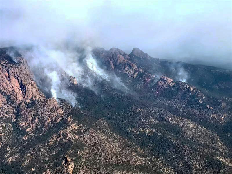
Most of the Hermits Peak Fire in the Santa Fe National Forest 12 miles northwest of Las Vegas, New Mexico is spreading in the Pecos Wilderness. While the transition is occurring from the Type 3 Incident Management Team to the incoming Type 2 Team very little current information is available. An unofficial estimate of the size after a mapping flight early Sunday morning puts it at more than 500 acres.
The weather will challenge firefighters for the next several days, with looming Red Flag Warnings Sunday and Monday and a Fire Weather Watch on Tuesday. The spot weather forecast for Sunday is for 10 to 14 percent relative humidity, an unstable atmosphere, the possibility of erratic, downburst winds, and general 22 to 30 mph winds gusting in the afternoon out of the west to 60 mph along ridges. Strong winds and low humidities will continue Sunday night and Monday. A longer range forecast predicts strong winds and low humidities persisting into Saturday, April 15.
The Incident Management Team said the fire could potentially spread in all directions on Sunday due to the predicted wind and topography.
The Hermits Peak Fire is a result of the Las Dispensas prescribed fire spreading out of control at 4:30 p.m. on April 6.
Overflow Fire
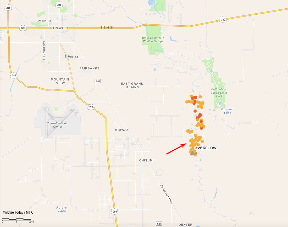
Another escaped prescribed fire, the Overflow Fire 10 miles southeast of Roswell, New Mexico, is burning in lighter fuels than the Hermits Peak Fire. Sunday morning it is still listed at 1,900 acres as the firefighters move into the mopup phase. Resources for the fire Sunday include five engines, two hotshot crews, and one bulldozer. Air support resources remain on standby.
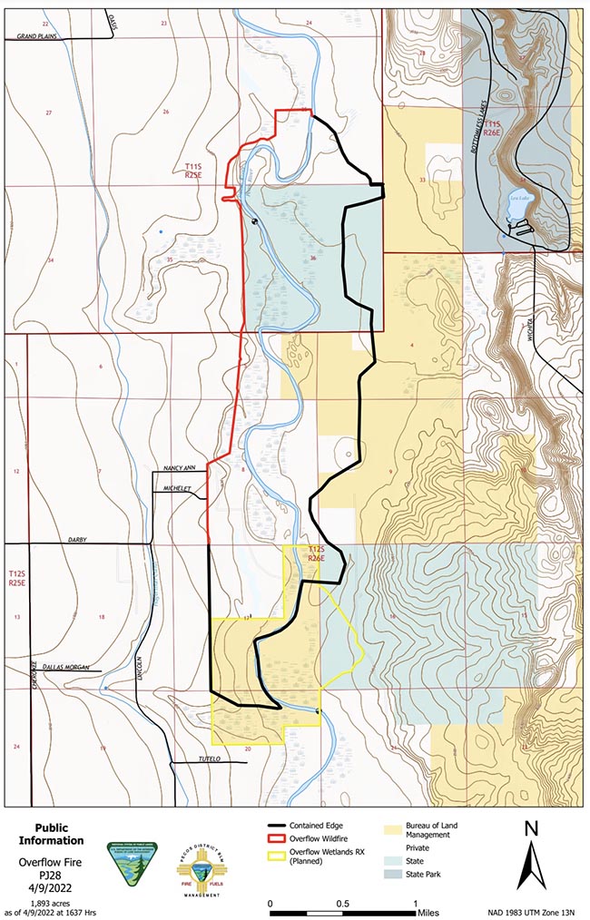
Map of the Overflow Fire, April 9, 2022. BLM.
A Red Flag Warning is in effect Sunday in Southeast New Mexico due to expected strong winds and low relative humidity. Monday’s forecast predicts similar conditions, with the Red Flag Warning remaining in place.
12:04 MDT April 9, 2022
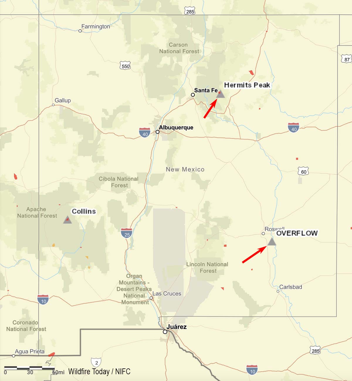
Map showing location of two escaped prescribed fires in New Mexico (at the red arrows).
Two prescribed fire projects in New Mexico have escaped and were declared as wildfires.
Hermits Peak
The Hermits Peak Fire on the Santa Fe National Forest is 29 miles east of Santa Fe and 12 miles northwest of Las Vegas, New Mexico. It escaped from the Las Dispensas prescribed fire at 4:30 p.m. on April 6 after the project was ignited late that morning. On Friday the U.S. Forest Service said it had burned approximately 350 acres after having been declared a wildfire. It is burning in mixed conifer in steep, rugged terrain. A Type 3 Incident Management Team assumed command on April 8 with the objective of full suppression. A Type 2 IMT, Southwest Team 4 with Incident Commander Aaron Hulburd, has been ordered and will inbrief at 9 a.m. Sunday.
It is moving toward the Pecos Wilderness. As of April 8 there were no direct threats to private property.
Hermits Peak Fire, April 8, 2022. USFS photo.Map showing the location of the Hermits Peak Fire at 10 p.m. MDT April 8, 2022.
In a statement released on April 6, the U.S. Forest Service said, “Although forecasted weather conditions were within parameters for the prescribed burn, unexpected erratic winds in the late afternoon caused multiple spot fires that spread outside the project boundary.”
Overflow Fire
The Overflow Fire has burned approximately 1,900 acres of salt cedar and grass 10 miles southeast of Roswell, New Mexico. The Bureau of Land Management was conducting a prescribed fire along the Pecos River corridor in Chaves County on April 7 when, the agency said, “an unexpected fire whirl carried fire across the control lines.” It was declared a wildfire at 1:25 p.m. April 7 and the strategy is full suppression. It has spread onto Federal, State and private lands.
Map showing heat detected on the Overflow Fire by satellites as late at 2:55 p.m. MDT April 8, 2022.
As of April 8 resources on the incident included six engines, two hotshot crews, and overhead from Chaves County, Carlsbad Fire Department, Ruidoso Fire Department, New Mexico Forestry, U.S. Forest Service, and U. S. Fish and Wildlife Service.
Weather
Early in the morning on April 6 The National Weather Service said there would be strong winds across Central and Western New Mexico that day. They issued a wind advisory for “northwest and central portions of the area” in effect from 2 to 7 p.m.
Another windy day is forecast across central and western #NM with areas of blowing dust developing during the afternoon hours. A Wind Advisory is in effect from 2-7PM MDT for northwest and central portions of the area, including the #Albuquerque Metro. #nmwxpic.twitter.com/MyvOcMhoQb
The spot weather forecast for the Las Dispensas prescribed fire which became the Hermits Peak wildfire was issued at 8:54 a.m. MDT April 6, a few hours before it was ignited. It predicted clear skies, 9 to 13 percent relative humidity, and winds at 20 feet to be out of the west at 10 to 15 mph with gusts to 25 mph possible.
A spot weather forecast for the Overflow prescribed fire issued the previous evening predicted for the next day clear skies, 7 percent relative humidity, and “north winds 5 to 6 mph shifting to the south 7 to 13 mph late in the morning.”
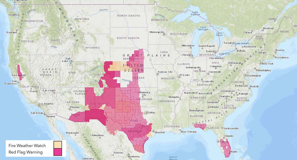
The National Weather Service has issued Red Flag Warnings in 9 states April 9, 2022.
The map represents the forecasts from multiple National Weather System offices at 7:50 a.m. MT April 9, 2022. The predictions are subject to change throughout the day.
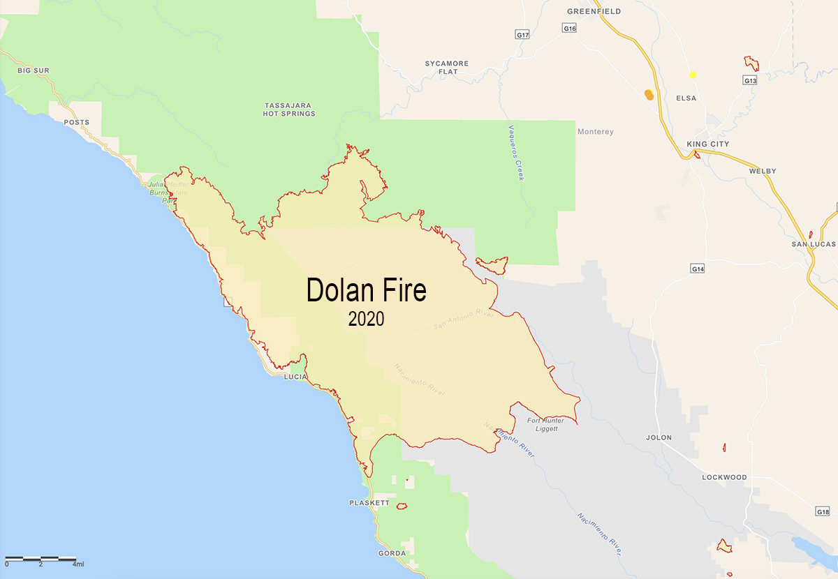
The blaze burned more than 124,000 acres along the coast and mountains of Central California in 2020
Ivan Geronimo Gomez. Monterey County Jail photo.
A 31-year old man was convicted Thursday of starting the Dolan Fire that burned 124,527 acres along the coast and mountains of Central California in 2020. A judge found Ivan Gomez guilty of arson, throwing rocks at a vehicle, cultivating marijuana, and 11 counts of cruelty to animals for killing multiple condors. In all Mr Gomez was found guilty of 16 felony counts.
After the fire started on August 18, California State Parks personnel detained Gomez at the John Little State Natural Reserve near the fire’s origin in Dolan Canyon. He had been seen throwing rocks at vehicles on Highway 1 and the Lime Creek Bridge. Mr. Gomez told officers that he had started the fire at an illegal marijuana grow on the other side of the ridge and killed five men.
Map of the 124,527-acre Dolan Fire, Central California, 2020.
There was no evidence of any homicides, but a multi-week investigation by US Forest Service fire investigators confirmed the fire did in fact originate at the illegal marijuana grow site. According to the Monterey County District Attorney’s Office, this piece of evidence proved to be key as the defendant correctly identified the area of origin, which was also confirmed by a defense expert. The evidence showed Mr. Gomez would have had time to start the fire around 5 p.m. and make it to the Lime Creek area where he was confronted at 8:15 p.m. Firefighters testified that no other individuals were found in this area and that the defendant was shirtless, sweating, and was found with multiple lighters on his person when contacted by law enforcement. The lighters were in working order and matched others found at the point of origin. In a three-hour interview with detectives from the Sheriff’s Department Mr. Gomez admitted numerous times that he started the fire.
The Dolan fire destroyed 14 structures including 10 residences. It also ruined multiple condor nesting structures and caused 12 condor birds to perish, injuring several more.
On September 8, 2020 the fire burned over and destroyed the US Forest Service fire station on Nacimiento-Fergusson Road seven miles from the California coast highway. Personnel there at the time included two USFS engine crews, two dozers with operators, and the only Division supervisor working the night shift due to a shortage of personnel. Fifteen firefighters deployed into only 13 fire shelters. Four were injured and three were hospitalized. One had very serious burns and had to rely on contributions from a GoFundMe account to help pay for his desperately needed long-term medical treatment, since the federal government dragged their feet in paying the bills.
The National Weather Service has issued Red Flag Warnings in areas of 11 states April 6, 2022 for winds, depending on the location, gusting at 35 to 60 mph and relative humidity in the single digits, teens, or twenties. In addition, most of the Northern Plains is under a High Wind Warning.
Red Flag Warnings, April 6, 2022. The text in the map shows the various warnings for Southern Nebraska.
Heat and Wind Advisories are in effect for areas near the Southern California coast.
Southern California heat and wind advisories near the coast, April 6, 2022. A Red Flag Warning is in effect for the area where California, Nevada, and Arizona meet along the Colorado River. NWS.
The maps represent the forecasts from multiple National Weather System offices at 11:50 a.m. CT April 6, 2022. The predictions are subject to change throughout the day.