Burning Weather Island

by Michael Hill
This feature originally ran in Wildfire Magazine
.

The peatland ecosystems of Central Kalimantan are transitioning from wildfire resistant to wildfire prone; with the potential huge release of carbon from burning peat stocks, it’s time for local and global actions to better protect these lands and communities.

As someone who has visited and observed wildfires in Indonesia for more than 20 years, I’ve witnessed the increasing loss of forest ecosystems and I recognize the potential for constructive international assistance.

Sebangau National Park
Sebangau National Park firefighters moving fire equipment on the fire ground. Photos courtesy of Sebangau National Park

In the Indonesian language, Kalimantan refers to the whole island of Borneo (the third largest in the world), while in English it describes just the 73 percent of the land mass located in Indonesia, containing about 70 percent of the island’s population.

Kalimantan covers 554,150 kilometers divided into five provinces and the non-Indonesian territories of Borneo, Brunei, and East Malaysia.

The meaning of the name Kalimantan — originally Kalamanthana — is burning weather island, referring to the very hot and humid climate.

Kalimantan is home to many cultures; the Dayak, or people of the interior, are Indigenous and have long used landscape fire in their agricultural practices to clean up land for slash-and-burn farming.

The smoke produced by burning peat is particularly hazardous. Besides its climate-warming carbon content, peat smoke contains toxins and other particulate matter, and in Indonesia, it is now being measured during times of wildfires as air pollution.

A volunteer firefighter with firefighting patrol boats on a fire in the Sebangau National Park, Central Kalimantan, Indonesia. District level volunteer firefighting brigades in Central Kalimantan are locally known as Masyarakat Peduli Api, or MPA firefighters.

This system of using fire to clear farming plots in the rotating system of land use allows for conservation; preselected areas or fields are used for a predetermined number of years before they’re allowed to go back to nature to recover fertility, while another field is cleared by cutting and burning to be ready for planting until its fertile cycle is complete. Then another field is cleared, and the small scale of slash-and-burn continues as the land recovers after farming.

This system of rotating agriculture and wildfires to clear land has been culturally important. The Dayak use of fire for cleaning and clearing was extremely controlled historically, with organized groups using pre-constructed fire breaks and advance planning to consider predicted winds and fuel conditions.

The Dayak have been masters of using fire as their tool to clear their forest lands. However, cultural, modernizing, and competitive economic forces have brought changes which, during a severe dry season, can quickly transform some areas of the Indonesian part of this island into a thick smoke-filled hazard, lasting months and impacting the surrounding islands and even the cities of Indonesia, Singapore, and Malaysia.

Recent changes in vegetation and culture have swung the Dayaks’ historic mastery of fire in Kalimantan out of balance. The Dayak people are no longer the only Indonesians who live in the interior of Kalimantan, where the rainforests long acted as a moist blanket to keep out fires or retard fire growth. Also, within Dayak culture, changes are taking place as the people join the wave of progress brought by globalism sweeping the world which, as a byproduct, disconnects us from the natural world and our hands-on, sustainable practices. The landscape is being modified and fire use has fallen outside of its traditional Dayak checks and balances.

While most of the fires in Kalimantan are human-caused, the fire origins are complex. Many past fires arose from the fact that land ownership claims in Kalimantan historically have been legally proven with the use of applying fire to land for clearing, thus establishing legal usage. Other blazes are ignited by accident — or by fishermen to attract more fish or drive away mosquitos — or fires are lit by hunters to attract wildlife, and myriad other reasons.

Sebangau National Park firefighter moving hose across fire ground. Photos courtesy of Sebangau National Park

But in recent years, during extra hot and dry seasons, when fires do get started in what may now be often lighter fuels, they can spread quicker and carry flames into forest areas, or even into the swamp peat forests. And once the peat layer below ground is lit, it will burn underground down to the water table and then move laterally beneath the surface, consuming important thick layers of organic decaying peat matter.

These burns can become huge subsurface peat fires with their flames not visible until they occasionally climb up to the surface to consume vegetation. But the heavy smoke from these peat fires, referred to locally as smog/haze, will have local, regional, and global impacts. The Dayak historically did not apply fire to the forest where there were peat layers beneath it, as they were burning for their agricultural fields and they knew their crops would not grow in the peat region.

Peat swamp fires on Borneo are unique for wildfires because the peat itself, created from countless generations of falling and then decaying organic forest matter, has been built up into massive locked-up carbon stores —  and these peat stores burn underground as a slow smolder, releasing heat and smoke to the surface. The thick carbon stockpiles begin to release their carbon when the peat swamplands they are part of are dried by drainage canals created to open lands for timber harvest, home building, and other uses. If this dried peat is then consumed by fires, the huge pool of stored carbon that had been safely locked away will be released into the atmosphere, causing global concerns for air pollution and climate change.

The smoke produced by burning peat is particularly hazardous. Besides its climate-warming carbon content, peat smoke contains toxins and other particulate matter, and in Indonesia, it is now being measured as air pollution during times of wildfires.

Kalimantan fires became an international concern in 1997 when a massive man-made ecological disaster burned in the peat forests, and since then, because of that disaster’s compounding effects, additional new dryseason peat fires have created an accelerating cycle of fires, peat loss, and flooding.

Peat’s organic matter, lying below the surface in a swamp forest, has long functioned as a natural sponge; the small percent of its decaying matter is able to soak up as much as nine times its volume in water. This layer of peat acts as an absorber to dampen the effects of seasonal flooding river systems. However, now with large areas of peat lost to wildfire seasons in 1997, 2015 and 2019, the summer dry seasons are followed by rainy seasons and large flows of water are draining from the burned peat lands into Borneo’s river systems and to the sea, leading to much human property loss and misery along the way.

Protecting the remaining peat beneath the swamp forests has become a priority in Central Kalimantan for those understanding the issue, and over the last 20 years, people have been adapting to the situation. Groups of people in Central Kalimantan have been organizing into both volunteer fire militia and paid fire forces, ready during dry seasons to fight fire. With the help of Japanese, Indonesian, and English scientists, new tactics and techniques are explored, and in 2015, there arose an international effort to assist in fighting wildfires. Indonesian law enforcement has also been activated to target illegal burners with stiff penalties of up to 15 years in prison and 15 million Indonesian Rupiah (about $930 USD) in fines.

Internationally, an agreement among Southeast Asian nations has been developed to assist during times of high fire activity, though there are still very real needs for which international assistance would be greatly appreciated and valued globally — by reducing the peat fires and their massive carbon releases.

Indonesia is still adapting to the emerging wildfire issues in Kalimantan, and as such, has so far developed only limited capabilities, with a particular need for shared technology in fire detection and wildfire response equipment. Many other fire-prone areas of the world have developed and routinely share these types of technologies, and Indonesia should be added to this group. Indonesia has unique firefighting technology advances to share, such as locally developed fire response systems and cloud seeding.

Aircraft dropping water on vegetation has been found to have limited effectiveness on peat fires, and therefore the fires are fought from beneath the ground. The priority is to find a water source on a peat bed nearby; this water source must be safely away from the fire to prevent its burning, and it’s usually found by drilling down as if through the ice on a frozen lake.

Using an augur to bore beneath the peat to find the water table, crews will tap into the water with a firefighting water pump and install a series of pipes and hose to carry water to firefighters, who spray it where needed to cool the flames. These firefighting pumps and their draft drill holes are strategically laid out and are manned with crews across the path of wildfire or in its wake, depending on the responding agency to act as anchor points,  working outward with the cooling water while supporting each other. This is hard work, Kalimantan style, but necessary.

Indonesians are also experimenting with Japanese-developed soap agents that can be injected underground into the peat to extinguish flames, and the Air Force is using weather modification by cloud seeding to create rain. It is truly a fascinating time of change and adaptation for wildfires in Kalimantan.

While these changes are internal, the funding and support for Indonesia’s efforts can come from beyond the region’s borders. Indonesia’s emerging wildfire issues are global issues, considering the potential climate impacts of the massive carbon releases from the peat.

Better protection of the peat reserves could be accomplished by a change of local land ownership laws to allow for proof of ownership to be legally established in new ways, thereby supporting long-term management, conservation, and restoration. Instead of the historic local use of fire to clean property, incentives could be created toward fire prevention. Tree planting instead of clearing could be transformed into legal proof of land ownership. Indonesia has huge stockpiles of reforestation funds at the government level, and some of these funds could be invested into bank loans to assist in these efforts and for program development (and local hiring and training for landowners).

Water-canal damming is undertaken to allow the saturation of dried-out peat soils; these efforts could be greatly assisted by the international community, and as an essential byproduct of healing these soils could begin to return more of Kalimantan’s fire-resistant blanket of forest with the added benefit of assisting in the fire protection of its peat lands.

The damage to the peat lands over the past 20-some years is immense; however, to protect the remaining peat lands and their carbon sinks would require only strategic forest replanting above the damaged areas, such as along waterways after the area’s water levels are again raised from canal damming.

Kalimantan’s El Niño dry season fires, especially in the peat swamp areas, have the potential to affect the world’s climate with their associated huge carbon releases. For this reason alone, Kalimantan and Indonesia should be offered more support internationally in their efforts to help to protect the remaining peat swamp forests.

Kalimantan may be an island that seems isolated and far away, yet when the peat fires burn they impact us all with carbon releases, whether we can see the smog or not.

Learn more about Kalimantan’s wildfires, nature, and the Dayak culture on Michael Hill’s YouTube channel, Talking Wildfires with Michael Hill.

Michael HillMichael Hill began this journey in the 1980s as an American wildland firefighter, and across his career worked as a hotshot and smokejumper. For many years Hill has been, and still is, deeply interested in Indonesia’s and Australia’s wildfires. He serves as an associate editor for Wildfire magazine.

Eastern Canada wildfire evacuates thousands

A fire east of Québec in Newfoundland and Labrador has burned more than 24,000 acres and forced thousands to evacuate Labrador City. CNN reported that the “extremely aggressive inferno” was considered contained earlier this week, but weather changes on Friday blew the fire back to life and it spread rapidly. Premier of Newfoundland and Labrador Andrew Furey said Saturday the fire had grown to 22,000 acres and had spread 13 miles in about four hours.

In a news conference on Sunday, Furey said weather conditions are favourable for firefighting. “We have some good news today. There is no significant growth in the size of the fire that is just northwest of Lab City,” he told reporters. The fire has burned through about 14,000 hectares (about 35,000 acres) to within four kilometres of the community — the same as Saturday.

Newfoundland and Labrador fires, ESRI map

Light rain, lower temperature and humidity, and northeast winds has kept  the fire away from the town and burning onto itself.

Four water bombers are fighting on the eastern front of the fire. Six to eight are fighting on the western side from Quebec.

Around 9,500 people were evacuated from Labrador City, said Jeremy Reynolds with the provincial government. “A contingent of essential personnel have remained behind to oversee the emergency response,” he said.

The remoted town of Labrador City, in the northwestern part of the province, is about 900 miles north of Canada’s capital city of Ottawa.

A province-wide outdoor fire ban prohibiting setting of fires on forest land or within 300 metres of forest land is now in effect in Newfoundland and Labrador.

Significant firefighting resources are currently dedicated to wildfire suppression near the communities of Labrador West.

Updates on the location, status, and size of active fires can be viewed online at the NL Active Wildfire Dashboard.

Labrador City fires
Labrador City fires

Residents were told to evacuate to the Town of Happy Valley-Goose Bay – a six-hour drive away.

Eastern Oregon fire burns to 73,000 acres

A new wildfire near the small Malheur County town of Brogan grew quickly to over 20,000 acres by Thursday evening, prompting closure of a 23-mile stretch of U.S. Highway 26 in eastern Oregon and evacuation alerts, along with call-up of two state structural-protection task forces, authorities said.

It’s burning on private and public lands 9 miles east of Ironside, and by this afternoon it was pushing 75,000 acres.

KTVB-TV reported that crews are battling two fires near U.S. Highway 26 in eastern Oregon. The Cow Valley Fire and the Bonita Road Fire both started early Thursday morning.

Others include the nearly 14,000-acre Larch Creek Fire south of The Dalles in Wasco County, which is still without any containment, and the nearly 4,000-acre Salt Creek Fire in Jackson County, about 16 percent contained.

The Larch Creek Fire grew from just 100 acres Tuesday afternoon, overnight and the next day, and by Wednesday night it was pushing 11,000 acres, according to the Oregon Department of Forestry. Zach Urness with the Statesman-Journal reported that the fire was at 13,816 acres Friday morning after more than 3,000 acres of growth overnight. The fire remains at zero percent containment, and Highway 216 east remains closed between milepost 1 and 4.

Thursday afternoon brought windy conditions to the area but fire behavior moderated overnight with lower temperatures and winds. Overnight crews worked closer to the active areas, building line and securing perimeters around Shadybrook Road and Highway 216.

“Today, air and ground crews will be active on all sides of the fire, building fire line, reinforcing existing line, and monitoring for hot spots. Structure protection will be focused on the community of Tygh Valley, Pine Hollow and Shadybrook subdivisions, and along Highway 216,


The Wasco County Sheriff’s Office has issued a Level 3 “Go Now!” evacuation order from Friend Road, East to Elliott Road and Highway 197, South to Badger Creek Road, West to McCorkle Grade Road.

Residents of at least 41 homes were advised to evacuate. Several other areas are under Level 2 and Level 1 evacuation orders.

Check the latest evacuation maps from the Wasco County Sheriff’s Office

The area was under a Red Flag Warning for critical fire weather on Tuesday afternoon.


There are 22 large fires burning Oregon totaling over 145,277 acres, according to the Northwest Interagency Coordination Center.

Early afternoon Friday Vale District BLM said the Cow Valley Fire had burned over 73,720 acres. ODOT shared photos on TripCheck of the Cow Valley Fire yesterday.

Between Ironside and Brogan, eastern Oregon.

KTVB in Boise reported 30-50 homes in Brogan are threatened, and power was shut down for customers at risk from powerlines close to the fire.

It was one of three large new area fires, along with the 4,500-acre Huntington Mutual Aid Fire in Baker County, which forced evacuations and alerts in the Huntington area and Farewell Bend State Park, and the 1,867-acre Bonita Road Fire, also in Malheur County, reported early Thursday morning.

The fire is moving toward Malheur Reservoir and is threatening 30 to 50 homes in the Brogan community. Malheur County Sheriff’s Office is advising residents to prepare for evacuation orders. At one point, 16 aircraft were assigned to the fire, dropping water and retardant, along with seven engines and four dozers plus crews from Vale and Burnt River RFPAs and Sand Hollow Fire District.

Indigenous knowledge to be used in future Australian bushfire research

Australia’s National Aboriginal and Islander Day Observance Committee (NAIDOC) Week started on July 7 with a commitment from bushfire researchers at the University of New South Wales (UNSW) in Canberra City.

The university has previously published numerous articles of landmark research on bushfires, including creating the world’s first extreme bushfire warning system, developing the first fire-retardant paint that passes the stringent BAL-40 test, and studying the long-lasting impacts of Australia’s “Black Summer” Bushfires.

University researchers have made a new commitment to future bushfire projects, vowing to incorporate more Indigenous practices.

“UNSW Canberra researchers are working to better incorporate Indigenous practices and understandings of fire in bushfire management, to better prepare for an increasingly uncertain future thanks to climate change,” a press release from the university said.

Similar to the practices of various Native American tribes, fire played an intrinsic role in the lives of Australia’s Indigenous communities of Aboriginal and Torres Strait Islander peoples for countless generations, and is still in use today.

Small controlled fires help them hunt, clear pathways through bush, and regenerate vegetation, according to The Nature Conservancy. “Cool Burns” have recently made a comeback after centuries of Euro-Australian suppression diminished the practice, caused by early colonizers’ view of fire as only a threat rather than a land-management practice. The loss of managed fire on Australia’s landscape, along with climate change, is a direct contributor to the severe bushfires that have burned the country since.

UNSW Bushfire Director Jason Sharples, a member of the Aboriginal Bundjalung people, said Indigenous fire knowledge adds needed depth to modern bushfire research.

“Local Indigenous people would know the land was ready for a burn when certain environmental indicators aligned, for example, when wattle flowers fell and when certain cloud formations were observed over prominent mountains,” Sharples said.

“Essentially, Country told them the right time to burn, and the people would offer fire as a gift back to Country. From a Western scientific perspective, this aligns with selecting the correct season based on the native flora, and only burning on a day when temperature and relative humidity conditions are within an acceptable range, as indicated by the cloud formations.”

UNSW is already working on two projects with the commitment to Indigenous practices in mind. One of the projects is studying how ridgelines, which correspond closely with Indigenous Songlines, cause unique wind patterns and influence fire spread. The other project compares modern bushfire regimes in southeast Australia with traditional fire regimes, Indigenous calendars, and cultural fire lore to better understand how climate change will affect future bushfires.

The university’s commitment pairs well with this year’s NAIDOC theme: “Keep the Fire Burning! Blak, Loud and Proud.” The theme conveys the strength and vitality of the nation’s Indigenous cultures which have stayed alive for generations despite historic and ongoing oppression and persecution.

“NAIDOC Week is a good opportunity to remind ourselves of the importance of promoting the cultural practices and learnings of Indigenous Australians and this will remain central to the work we do within UNSW Bushfire,” Sharples said.


SEAT crashes in Montana reservoir

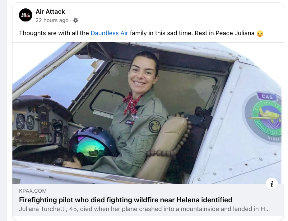
A pilot on the Horse Gulch Fire in Montana died Wednesday when  her single-engine airtanker (SEAT) crashed into Hauser Lake. Lewis and Clark Co. Sheriff/Coroner Leo Dutton says the 45-year-old pilot Juliana Turchetti was the only person onboard.

Juliana Turchetti, Dauntless Air

Lewis & Clark County Sheriff/Coroner Leo Dutton said Juliana Turchetti was killed when her plane crashed into a mountainside and landed in Hauser Lake. Turchetti was employed by Dauntless Air, a firefighting company that operates a fleet of single-engine airtankers

Originally from Brazil, she was in the U.S. on a visa. KPAX-TV reported that Turchetti leaves behind a 17-year-old son and numerous family members in Brazil. According to agriculture aviation magazine AgAir Update, Turchetti was one of the first women ag pilots in Brazil.

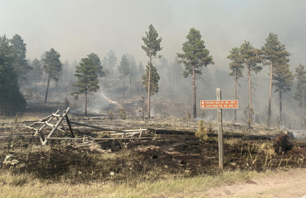
The fire’s been burning on the Helena-Lewis and Clark National Forest since mid-day Tuesday in dense timber with heavy dead and down fuels; Wednesday included extreme fire behavior pushed by winds, and the fire’s grown to over 1,000 acres — still at zero percent containment. The Northern Rockies Team 2 is in charge; they were moving resources onto the southern flank to protect critical values at risk there.

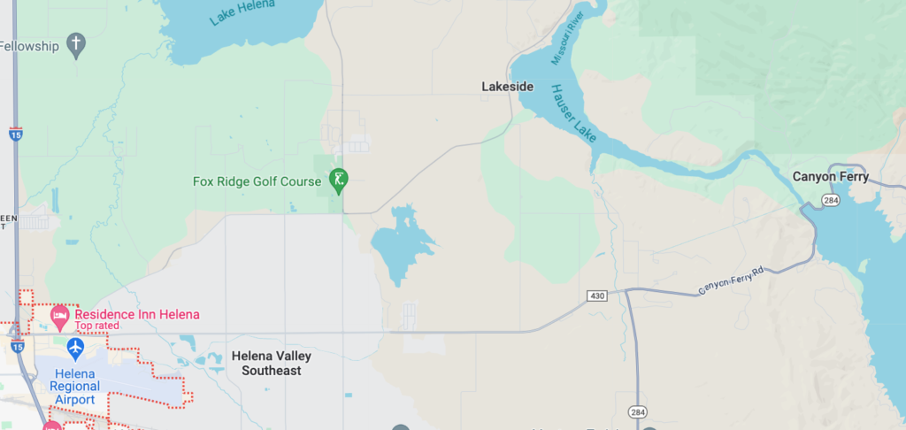
Hauser Lake
Hauser Lake

The aircraft, a 2013 Air Tractor AT-802F Fire Boss owned by Aero Spray (now Dauntless Air), was contracted by the Forest Service and was flying out of Coeur d’Alene and scooping from Hauser Lake, one of a series of dammed lakes on the Missouri River upstream of Mann Gulch. The Fire Boss crashed into Hauser Lake, near Canyon Ferry Lake 20 miles northeast of Helena, while scooping water for dropping on the Horse Gulch Fire. The pilot was killed and the aircraft was written off. Lewis and Clark County Undersheriff Brent Colbert confirms the pilot’s body was recovered.

Horse Gulch Fire July 9

Numerous roads in the area have been closed after firefighters complained that people were trying to get close to the fire for photographs, and the sheriff’s warned residents to either evacuate or stay put, and told others to get out of the fire area.

Two more large scoopers are en route to the fire, along with resources from area VFDs and the Montana DNRC.

KTVH-TV reports that the area from Cave Gulch to Magpie Gulch on the north and south sides of Canyon Ferry Rd. is evacuated. Riverside Campground has been closed and there is a pending order to close the national forest in the area of the fire. Expected weather includes hot, dry and windy conditions with RH of 9-14 percent, and winds of 10-15 mph with gusts of 25 mph.


India state’s officials blame pine trees for wildfire severity. Experts say that isn’t the full story.

An article written by The Wire author Hridayesh Joshi breaks down systemic issues facing the wildland firefighting force in Uttarakhand, India.

More than 1,200 forest fires burned this year in Uttarakhand and claimed the lives of at least ten people, including some forest guards. In response, state officials have orchestrated a statewide campaign against pine tree litter, called “Pirul Lao-Praise Pao,” or “Bring Pine Litter, Take Away  Money.” The program incentivizes locals to collect piles of pine needles that litter the state’s forest floor. Uttarakhand Chief Minister Pushkar Singh Dhami even recorded himself scraping up pine needles to promote the program.

“Under the campaign ‘Pirul Lao-Paise Pao,’ a large number of people are collecting pine needles and selling it to the government at the rate of ₹ 50/kg,” (about 60¢ USD per 2.2 lbs.) Dhami said. “At present, due to this campaign, the incidents of forest fire have reduced significantly and the villagers living near the forest area are also earning income.”

In May, the Uttarakhand government suspended 10 frontline Forest Department employees as nearly 1,350 hectares (3,336 acres) of Himalayan hills remained burning for nearly a month. The decision to suspend the forest guards and foresters followed an emergency meeting of senior government officials with Chief Minister Dhami. He postponed his scheduled engagements to chair the meeting with the Forest Department officials.

“Ten employees have been suspended in different areas,” he said, “five were attached to the forest headquarters and two were issued showcause notices for dereliction of duty leading to massive fire incidents since April 1.”


Trivendra Singh Rawat was the first Chief Minister in the state to start a pine needle collection program by linking it to the Mahatma Gandhi National Rural Employment Guarantee Act (MGNREGA) after coming to power in 2017, according to the Statesman.

“Around 25 lakh (~2.5 million) metric tonnes of pine needles are produced annually in the state,” Rawat said. Researchers at India’s  Central Institute of Agricultural Engineering found that pine needles, if heated with an absence of oxygen through pyrolysis, could be converted into a bio-oil and used in blended fuels. Rawat estimates that volume of pine needles could generate nearly 200 MW of power.

Experts, however, say the state’s narrative focus on pine needles as the cause of wildfires misses the mark because pine duff is an easy scapegoat for government officials to focus on rather than the more systemic issues of inadequate forest staff, drought, and a widespread absence of fire breaks.

“One could argue this campaign was the government’s attempt to pivot the blame away from grim ground realities and solely toward these aged pine trees,” Joshi wrote. He said, instead of addressing all these issues together, the Uttarakhand government’s decision to “villainize” one species is a myopic strategy and will prove to be detrimental in the long term. Pine is just one conifer standing among many other species on the Himalayan slopes. Focusing solely on pine shows the government’s misunderstanding of the larger Himalayan ecosystem and is leading to unsustainable solutions to the forest fire issue.

Pine trees have made up an integral part of India’s mountain forest cover since the Himalayas first formed. Collection of pine needles alone won’t be enough to control forest fires, experts told Joshi. Instead, the state should create a more holistic approach that addresses the human causes of forest fires.

Read the full article here.

factors

World’s largest tropical wetland burned this year

Record-breaking wildfires between January and June burned an ecological foothold — and biodiversity haven — spanning across Brazil, Bolivia, and Paraguay this year, just four years after similar fires burned 13,300 acres of the preserve.

The Pantanal is considered the world’s largest tropical wetland area, the world’s largest flooded grasslands, and one of the most important areas of freshwater in the world.

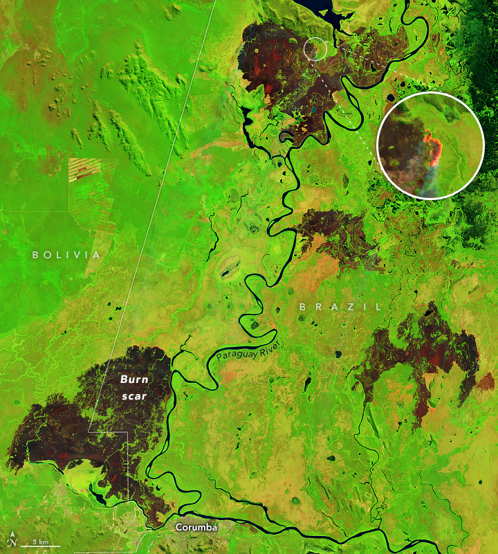
NASA captured some of the intense fires’ burn scars in satellite imagery.

“Fire season in southern Brazil usually starts in July and peaks in August and September,” NASA said. “The false-color images emphasize the burn scars (brown) from several of the fires. Unburned vegetation is green. Near- and short-wave infrared bands help penetrate some of the smoke to reveal the hot spots associated with active fires, which appear orange.”

Pantanal fires
Pantanal fires June 2024

The repeated fires have left the environment in a state of constant recovery — and nearby communities are struggling.

“We were just trying to recover from the 2020 fire, which devastated our Pantanal. We had not fully recovered and now we are facing this again,” said a volunteer firefighter with the Baia Negra Environmental Protection Area’s Association of Women Producers.

A recent report from MapBiomas Brazil, a collaborative initiative including NGOs, universities, and technology companies, sheds light on a major cause of the fires: surface water loss.

Edge effects
Edge effects on the native vegetation and continuous habitat — including exposure to wind and solar radiation, susceptibility to fire, increased predation rates, and

The Pantanal is the biome in Brazil that has dried up the most between 1985 and 2023. The report said annual water surface for the area last year was just under 944,000 acres — only 2 percent of the wetland biome was covered by water. The total is reportedly 61 percent under the historical average. The area was 50 percent drier in 2023 than it was in 2018 when the area’s last major flood happened.

“In 2024, we didn’t have a flood peak,” said Eduardo Rosa with  MapBiomas. “The year has seen a peak drought, which should last until September. The Pantanal in extreme drought is already facing fires that are difficult to control.”

The report also found that the entire Amazon region suffered a severe drought with a decrease of 8.2 million acres of water surface.

Up to 25% of Brazil’s native vegetation may be degraded

A new platform from the MapBiomas network shows that between 1986 and 2021 Brazil had between 11 and 25 percent of its native vegetation susceptible to degradation. This corresponds to an area ranging from 60.3 million hectares to 135 million hectares.

Fire effects over time
Visualized fire effects over 7 years, resulting from a single burn or multiple burns.

About 64 percent of Brazil — more than half the country — is covered by native vegetation. The beta version of MapBiomas’ degradation vectors platform makes it possible to generate unprecedented scenarios of the impact of factors that can cause degradation on native vegetation across  Brazil.

“This is the first time that degradation can be assessed in a broader way and in all Brazilian biomes,” says Tasso Azevedo, general coordinator of MapBiomas. “But we know that this degradation process occurs in other types of cover, such as agriculture and pasture, as well as soils and water, where we also intend to advance with this information in MapBiomas in the coming years.”

  ➤ View the main highlights [PDF] of the Degradation module

The degradation vectors considered by the MapBiomas team in this first edition of the platform include the size and isolation of the native vegetation fragments, their edge areas, the frequency of fire and the time since the last burn, as well as the age of the secondary vegetation.

Pantanal: fire as a factor in degradation

In the Pantanal, the degraded area can vary from 800,000 hectares (6.8 percent) to 2.1 million hectares (almost 19 percent). Although it is a biome that coexists with fire, the incidence of fires in the last five years has meant that 9 percent of the Pantanal’s forest formations, which are fire-sensitive areas, have been damaged.

Eduardo Rosa with the MapBiomas’ Pantanal team says some of the vectors of degradation in the Pantanal beyond this analysis must consider the entire biome’s surroundings, since all the rivers that naturally irrigate the Pantanal plain are born in plateau areas. “The removal of native vegetation for agricultural and livestock expansion unprotects the soil and interferes with the distribution of water and sediment. The quantity and quality of water that reaches the plains also depends on dams and hydroelectric plants that alter the natural flow of water,” he says. “Climate issues relating to rainfall and temperature regulate droughts and floods, and the increase in periods of drought has hampered the resilience of the Pantanal ecosystem.”


Aero Union 1960 – 1997

Aero Union’s Past Demonstrated Ability

~ contributed by cbk


We received this lovely little piece of historical documentation of the tanker operations — for 37 years — of Aero Union’s fleet, including its P-3 Orions flying out of Chico in northern California. The much-missed red/white P-3 ships were the last of a long line of Aero Union’s many airtankers, the red/white icons of aerial firefighting. Not many companies have a history so impressive.

Aero Union airtanker operations 1960 – 1997

Aero Union Operations 1960-1997

Aero Union operations 1960 - 1997

Aero Union operations 1960 - 1997

Aero Union operations 1960 - 1997

Aero Union operations 1960 - 1997

Aero Union operations 1960 - 1997


ON THIS DAY … 1994 and 2014

A little note and a little request — by Patrick Carnahan
 ~~ July 5, 2014
Still can’t believe we are only hours away from marking the 20-year anniversary of the fire on Storm King Mountain. I’m now 12 miles away from the parking lot I was in when Paul Harvey told us we’d just lost 14 firefighters on the mountain.

Our strike team had orders to go to that fire and we got stopped leaving camp and re-routed to another fire. We drove 3 times as long to fight another fire as it would’ve taken us to be on the South  Canyon Fire. We reached our assignment just as the flames were crossing the road into a remote community and we fought fire for the next 14 hours. Lost a wooden deck but no structures.

I remember everything in sight that night was on fire; it looked like hell, and there was no place else any of us would choose to be. Had about 4 hours of sleep and the first hot meal in 6 days when we got the news. Nobody really said anything at the time. We all understood we should’ve been on that mountain. Spent the next 5 days in a haze of smoke and flames before we were demobed. I have lost a couple of friends since then and many more I never had the opportunity to share the line with. Glad that the ignorance of youth was not wasted on me and I’m still here.

Asking that you all take a moment out of your day tomorrow and recognize those who never came off the line. Fire will always be a part of our reality and it will never be a job free of risk. When the next report hits the news about a wildland firefighter losing his or her life on a fire, please go here and make a difference:  The Wildland Firefighter Foundation.

Keep one foot in the black and stay safe out there. For those who have gone on, save me some line to work when the time comes.
P.C.

And a revisit from a few years ago of one of Bill Gabbert’s best pieces:

Thompson Fire burns in northern California

Thousands were ordered to evacuate in northern California ahead of a fire  burning in Butte County, as an “exceptionally dangerous and lethal” heat wave in the West is building. Cal Fire reported that three firefighters suffered injuries on the fire and thousands of people were still evacuated early today  near Oroville. Several others were injured today. 

Soaring temperatures — forecasted to hold into next week – have parched the already-dry vegetation in the area.

The Mercury-News reported that the Thompson Fire has spread around Oroville Dam — the tallest dam in the United States — at one point burning on the dam itself.

Authorities initially evacuated more than 28,000 people from Oroville and  neighboring communities in Butte County, and by Wednesday the fire had grown to almost 3600 acres with zero containment and temperatures well into the triple digits.

Gov. Gavin Newsom declared a state of emergency for the fire area, according to CNN,  bringing on  additional suppression resources including the California National Guard.

The Mercury-News has a dandy photo gallery online; they reported that the Thompson Fire was one of a half dozen wildfires that started Tuesday in northern California and the Central Coast; it took off around 11 a.m. near Oroville.

More than 1,400 firefighters were working the fire, along with eight helicopters, 199 engines, and 46 bulldozers. Several large airtankers also were on the fire.

The town is about 20 miles south of Paradise, where the catastrophic Camp Fire killed more than 70 people in the 2018 disaster. The city of Oroville’s July 4 fireworks celebration was canceled by California State Parks on Wednesday.