NIFC: When all the West is on fire at once, this is who deals with it

A command center in Boise is responsible for deploying America’s strained firefighting resources as more than 100 wildfires burn across the country.

By Joshua Partlow
July 28, 2024 at 6:00 a.m. EDT
Republished with permission by the Washington Post


BOISE, Idaho — As Sean Peterson took his seat Friday morning in the nation’s nerve center for fighting wildfires, 104 large fires raged uncontained across the United States.

The federal government’s firefighting resources were already fully committed, but requests from regional coordination centers kept pouring in.

The day before, his office had turned away requests for 37 aircraft, 40  engines, and hundreds of specialists from dispatchers to heavy equipment bosses. Six hundred more requests had landed that morning. The Park Fire in northern California was exploding at a pace that horrified and amazed even the hardened veterans here. A firefighter injured by a tree had been evacuated to an Idaho hospital. And an aircraft had gone missing overnight amid the smoke billowing from Oregon’s Malheur National Forest.

Peterson, with his can of Liquid Death on the conference table, scanned the room before the morning briefing.

“Ready to rock and roll?” he asked.

When all the West is on fire at once, this is who deals with it.

Peterson manages the 32 employees at the National Interagency Coordination Center (NICC), a key part of the National Interagency Fire Center (NIFC) on the fenced-in federal government campus abutting the Boise Airport. The staff, including personnel with the U.S. Forest Service, Bureau of Land Management, Bureau of Indian Affairs, and other agencies, must constantly weigh the threats of multiple rapidly changing fires and deploy their limited resources where they can do the most good.

After weeks of extreme heat and waves of lightning storms, there is so much fire burning now that the U.S. has reached Preparedness Level 5 (PL5), something that has happened this early in the summer only four times in the past 20 years, according to staff here.

At times like this, there’s never enough help.

“No fires are going to get everything that they want,” Peterson said.

The vibe here is not Situation Room suits and ties. It’s looser and more outdoorsy: short sleeves and jeans, sandals and tattoos. But it’s serious work.

On the video conference, Jeff Walther, a representative from the Pacific Northwest region, informed the group that a single-engine airtanker had gone down the night before while fighting a new blaze near the Falls Fire on  the Malheur National Forest.

“Ground crews are out there this morning trying to locate,” Walther said. “Pretty difficult terrain. Smoke’s still hampering the area.”

“Thanks Jeff, and definitely, our thoughts from here, along with everyone in the dispatch coordination community, hoping for the best,” Derrek Hartman, the center’s deputy manager, told him. “I feel terrible for the situation going on.”

The Forest Service and the Grant County Sheriff’s office later confirmed that the pilot had died.

The staff at the coordination center are familiar with these risks. Nearly all of them worked as firefighters. And many have worked together for years or decades, building a camaraderie and rapport that helps them navigate the logistical maelstrom on any given day.

Peterson, a third-generation firefighter with a scar on his right cheek from one of his close calls, grew up in California and took his first firefighting job two weeks out of high school. He was raised partially in Paradise, the mountain town that was demolished by the 2018 Camp Fire, one of the deadliest fires in U.S. history. Both of his childhood homes there went up in flames.

Over his three-decade career, he has watched as fires have grown in scope and intensity. He’s lived to see a winter fire that burned more than 1,000 homes. Forests hit by repeated fires that have transformed into quick-burning grasslands. When he started, he said, a 50,000-acre fire was a very rare occurrence.

“Now that’s the norm,” he said. “Right now we have six fires burning over 100,000 acres. And we haven’t even got to August yet.”

Peterson acknowledges that warming temperatures from climate change are part of the story but he also believes the decline of the logging industry — including clearcuts that helped thin the forest and gave firefighters anchor points from which to work — is to blame for the country’s worsening fire problem.

This summer’s quick explosion has followed two relatively light fire years, as abundant winter rain and snow has nourished the West. To fire experts, wet winters mean more grass, which eventually dries out and turns to kindling when the heat cranks up.

“We can turn good news into bad news like nobody’s business here,” said Steve Larrabee, a Bureau of Indian Affairs official who is the center’s fire and fuels analyst.

This year got off to an ominous start when wildfires in Texas and Oklahoma burned more than a million acres. “We just don’t get million-acre fires in February,” Larrabee said. In the past several weeks, there have been many major fires in the Pacific Northwest and California. Now, the Great Basin and Northern Rockies are lighting up, too. About 3.8 million acres have burned in the U.S. so far this year, above the average over the past 10 years of 3.4 million acres.

Larrabee tracks metrics of the dryness of dead trees and vegetation. He is concerned that the numbers seem okay but aren’t really corresponding with the “spectacular fire behavior” now showing up in parts of the West.

“These things that are usually fire barriers, like green vegetation, they’re not working like fire barriers like they normally do,” he said.

The biggest crisis right now is northern California’s Park Fire, near Chico, which has burned more than 300,000 acres in less than three days. Officials suspect an arsonist started the inferno that now threatens thousands of homes. Evacuation orders are in place for several communities, including  what’s rebuilt of Peterson’s hometown of Paradise.

“It will be one of the largest — if not the largest — and one of the most devastating fires on record in the country when it is all said and done in the fall,” Peterson said on Saturday.

Amid all of this, the coordination center must steer desperately needed firefighting resources around a constantly shifting map.

On Friday, fire managers from the Great Basin, with 26 new fires ignited the day before, said they needed all types of crews and aviation support. Meanwhile, the Northern Rockies, battling 77 new fires, wanted smokejumpers and rappellers.

Shortages at such a time become more glaring. All 27 contracted caterers who feed fire camps have already been committed, so beyond that, teams  will have to buy meals from whatever local providers they can find.

The day before had reached a high-water mark for demand this year for infrared flights to map fire perimeters and work new fires, with 81 requests. And the federal government’s 91 single-engine airtankers were also all spoken for, staff here reported.

There are 26,020 firefighters deployed just on large fires, the most this year. More help is needed.

Peterson met on Thursday with officials from Australia and New Zealand, longtime firefighting partners of the United States. Those countries agreed to send 80 people, including personnel in sorely needed middle management positions such as division supervisors and task force leaders. The most critical shortage, Peterson said, was in local fire dispatch centers, where there are more than 100 vacancies. People in these grueling jobs field 911 calls and coordinate the response to new and growing fires.

“Nobody wants to do it anymore because they’re just burned out,” he said. “It never stops.”

And there’s no respite ahead. Red flag warnings were peppered across the West with wind gusts expected up to 45 mph. Smoke from Canada’s fires, also raging, had finally reached Europe, one staffer noted, just as the Olympics were starting. Outside the nation’s firefighting command center, yellow smoke hung low over Boise.

At the end of the morning briefing, Peterson reminded his staff to take care of themselves.

“This is going to be a marathon,” he said.

Joshua Partlow, Washington Post

Falls Fire SEAT pilot missed

The wildland firefighting community in Oregon and beyond mourns the loss of one of their own. The Grant County Sheriff in eastern Oregon confirmed that SEAT pilot James Bailey Maxwell, 74, was killed while working near the Falls Fire near Seneca on the Malheur National Forest on July 25, 2024.

The BLM said Maxwell had dropped retardant on the Parasol Fire north of the Falls Fire and was returning to the base at Burns to reload. He disappeared just before 7:00 p.m. Thursday. Owned and operated by North Dakota-based Aerial Timber Applicators, the aircraft was reported missing and triggered a search by numerous agencies including a night-flying helicopter with the Oregon National Guard.

Search and rescue teams searched overnight and located the aircraft Friday morning in steep terrain.

Maxwell was a long-experienced pilot who’d spent 54 years of his life flying and had logged approximately 24,000 hours of flight time. He will be missed by family members in Idaho, Oregon, and Washington.
Falls Fire ICP
Falls Fire ICP

The Falls Fire today is almost 70 percent contained at 142,30 acres.

The Maxwell family and firefighters are grateful for the support expressed throughout the community and online. Services have not yet been announced and the family requests time and privacy.

Malheur National Forest, John Day, Oregon

SEAT crashes, pilot killed south of John Day on the Malheur

An early report by KOIN-TV indicated crews were searching for a lost airtanker that disappeared late Thursday. The BLM-contracted SEAT went missing while fighting a lightning-started fire near Seneca, Oregon. The Central Oregon Daily News said the pilot was en route to a spot fire near the the Falls Fire and was killed in the crash. The BLM confirmed that the wreckage was found and the pilot’s body recovered; the pilot’s identity has not been released.

The Aviation Safety Network reported that an Air Tractor AT-802A owned by Wakefield Aircraft out of North Dakota crashed near Seneca, with one occupant, unknown injuries, and unknown aircraft damage.

The plane went missing around 7 p.m. while working a lightning start near the Falls Fire. The Grant County Sheriff’s Office and Falls Fire personnel immediately began a search and the Oregon National Guard searched overnight without success. Grant County Search and Rescue on Friday joined the search.  KGW-TV said the SEAT was flying out of Burns, about 45 miles from Seneca via US-395. The Falls Fire’s about 25 miles south of John Day.

Falls Fire 07/23/24 ~ IMT photo
The Falls Fire was at 141,926 acres and 55 percent containment, according to a KTVB-TV report. On Friday afternoon that was updated to 55 percent contained at 140,422 acres.
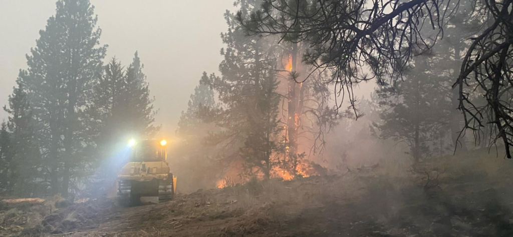
Falls Fire 07/24/24 south of John Day, Oregon on the Malheur National Forest.
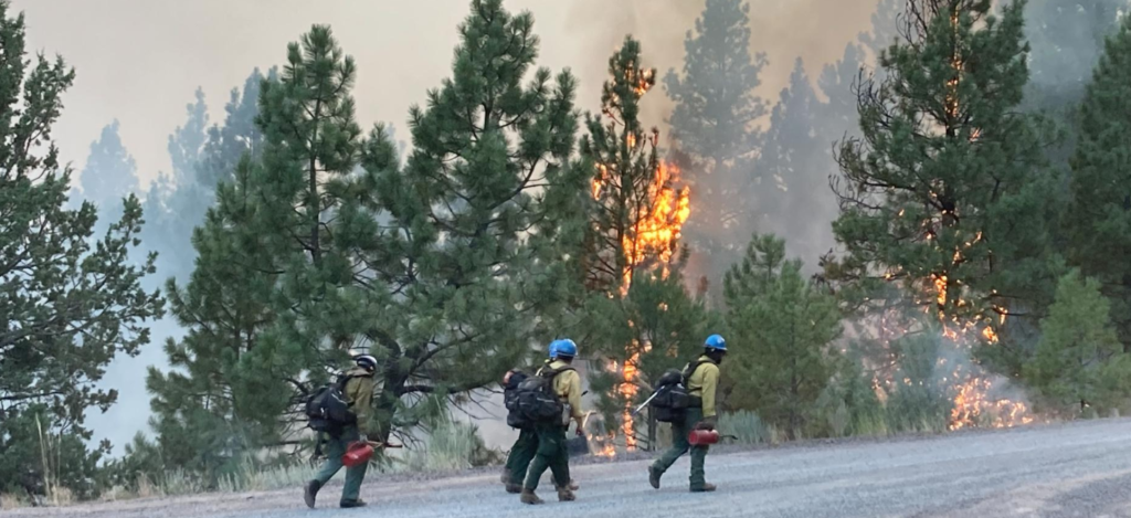
Dozer div on the Falls Fire 07/2024

KPTV reported that fire managers reported the aircraft missing on a lightning-started fire on the Malheur National Forest. Search crews have been hunting for the plane since Thursday night and will continue Friday.

The fire was human-caused and is under investigation. Investigators ask for the public’s assistance with any tips or information about the start of the Falls Fire on the Malheur. Please email tips to   SM.FS.R6TipHotLine@usda.gov

Threatened property includes 377 homes, 118 commercial buildings, and nearly 700 outbuildings. Resources include 38 crews, 79 engines, 24 dozers, 25 watertenders, plus helicopters and SEATs, for a total of 1560 personnel.

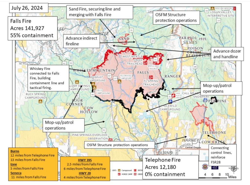
Falls Fire map

The Alaska Complex IMT 1 assumed command of the Falls and Telephone fires at 6:00 am Friday and is in unified command with the Oregon State Fire Marshal (OSFM). Their thorough update for today is posted online [HERE] but includes no mention of the crash or the search for the missing SEAT. The Harney County Sheriff’s evacuation map is [HERE] and  the Grant County Emergency Management wildfire info page is [HERE].

Strong afternoon winds together with extremely dry fuels increased fire behavior on the Telephone Fire, and several new starts were identified east of the Falls Fire in the Parasol Butte area. Evacuation levels were announced and extended in response to the new starts and the Telephone Fire’s move across FSR 28.

Crews responded along with aerial resources, and structure protection crews mobilized and responded to the area. The Telephone Fire has grown 3,000 acres and moved farther southeast overnight; it’s now about 4 miles north of Hwy 20. Smoky conditions are expected to continue; an inversion layer sits over the fire but may lift by early afternoon. Temperatures have been in the mid-80s.

~ Thanks and a tip of the hardhat to Jeff on this one. 

The wreckage was found and the pilot’s body has been recovered, according to Lisa Clark of BLM. The pilot’s identity and the precise location of where the plane was found was not released

Park Fire rips across 125,000 [353,000] acres in northern California

RyanWeather.com
Park Fire Morning Update 8 AM 7/28/24
From the Northern California Coordination Center:

CA-BTU Park: 353,194 acres grass, brush and timber, 12 percent contained. Extreme fire behavior reported with long-range spotting. Multiple communities are threatened. Structures are threatened with evacuation orders and warnings in place. Critical infrastructure, communication sites, power transmission lines, and private timberlands threatened. Threatened and endangered species, cultural and natural resources are also threatened.

Park Fire tanker drop 07/26

Lassen National Volcanic Park is closed and the town of Paradise is under evacuation warnings.

Highways 32, 36 and Cohasset Road are closed in the fire area with additional threats to Highway 99. Numerous other road, area, and trail closures in effect. The incident is under unified command with CAL FIRE Team 3 (See), CAL FIRE Team 4 (Martin), and the Lassen National Forest.

Park Fire 07/28/24
Park Fire 07/28/24

Though the cause was earlier reported as under investigation, the Chico ER reported that investigators had arrested a Chico man suspected of igniting the fire.


07/26 FRI a.m. Park Fire burns to 164,286 acres, over 4,000 evacuated

The burned-out car that CAL FIRE investigators traced to the start of the Park Fire in Chico. The suspect is in Butte County Jail. ~ Butte County District Attorney's Office photo.
The burned-out car that CAL FIRE investigators traced to the start of the Park Fire in Chico. The suspect is in the Butte County Jail.
~ Butte County District Attorney’s Office photo.

The 42-year-old suspect is facing arson charges. Butte County District Attorney Mike Ramsey said Thursday that investigators apprehended Ronnie Dean Stout, a twice-convicted felon and registered sex offender.

Investigators followed up on local reports of a man pushing “a car on fire” into a gully and down a 60-foot drop near Alligator Hole in upper Bidwell Park midafternoon on Wednesday. Ramsey said the guy was seen calmly leaving the area as the fire took off.

The fire spread from the car, which Ramsey said was Stout’s mother’s car, and grew 45,000 acres overnight; it was estimated Thursday afternoon at 75,000 acres.

It’s at 125,000 acres tonight burning in both Butte and Tehama counties; numerous firefighting airtankers from throughout the state are flying as conditions allow, along with over 1,100 personnel assigned, 6 helicopters, 41 dozers and 10 watertenders, 40 crews, and 153 engines.

A fire whirl was spotted at the Park Fire in the early evening hours of July 25, 2024.~ AlertCalifornia camera
A fire whirl was spotted at the Park Fire in the early evening hours of July 25, 2024.
~ AlertCalifornia Platte Mountain camera in Butte County    Click photo to watch video
A fire tornado or fire vortex developed from the intensity of the fire on July 25. The time-lapse was captured by the ALERTCalifornia Platte Mtn 1 camera. The camera sensors can see 60-70 miles on a clear day and more than 120 miles on a clear night. Watch ALERTCalifornia’s more than 1,080 (as of July 2024) monitoring cameras live at  cameras.alertcalifornia.org 
The Park Fire was started at 3:00 p.m. yesterday and by 8:00 p.m. the IC had  requested 30 strike teams of any type engines. (Holy immediate need Batman, 150 engines!)
View from Hamilton City about 7 p.m. July 25
PARK FIRE: View from Hamilton City about 7 p.m. July 25
CAL FIRE said the fire displayed dynamic fire activity overnight. Winds are definitely a factor and the temperatures are in the 80s. Three helicopters were available for night ops, and they spent the night finding hotspots to drop water on. CAL FIRE has a dandy photo collection on flickr, including timelapse images of the smoke at the fire’s origin.
Richardson Springs camera yesterday at 8 p.m.
~ Gracias and a big tip o’the hardhat to Pat for this …

Australian and New Zealand firefighters head to Canada as part of years-long partnership

The British Columbia Wildfire Service recently welcomed a group of 60 IMT members and specialized personnel from Australia and New Zealand to assist throughout the province. Another 30 went to Alberta.

The firefighters arrived in Canada as part of a years-long partnership through the Canadian Interagency Forest Fire Centre (CIFFC).

“The relationship between the B.C. Wildfire Service and Australia is  longstanding, extending more than 15 years of mutual aid, support, and knowledge transfer,” they said. “The first instances of support started during the 2007 wildfire season in Australia, when B.C. assisted by sending more than 60 personnel to support fire suppression efforts.”

CIFFC is a not-for-profit group operated by Canadian wildland fire management partners and shares resources and mutual aid throughout the nation and internationally using the Canadian Interagency Mutual Aid Resource Sharing (MARS) Agreement — and the Australasian Fire and Emergency Service Authorities Council during wildfire seasons. CIFFC has a similar agreement with the U.S.

During the catastrophic 2021 season in British Columbia, the B.C. Wildfire Service was able to rely on these arrangements to request support from other Canadian provinces, the federal government, Mexico and Australia. CIFFC supports this coordination of resources.

current Canada fires

Fire officials attribute the strong relationship between the nations to a shared understanding of how to approach emergency management.

“The agencies operate similarly in terms of warning systems, collaboration, and information sharing. We share a lot in common when it comes to fire behavior as well. Large bushfires and wildfires that can cause significant impact to close-by communities and property, hot dry and windy conditions, and fires with ability to grow quickly are not uncommon for the two nations.”

Nine of the 90 total firefighters came from the South Australian Country Fire Service (CFS), according to the South Australian government; the deployment could last up to 40 days.

“I feel humbled and honored to have this opportunity to travel to Canada to support their firefighters in a time of need and to deploy the skills I have learned over the years and to learn some new ones,” CFS Divisional Commander Phil Tapscott said. “These opportunities always reaffirm that what we do here in the CFS is of a very high quality.”

Around 883 wildfires have burned in British Columbia since the beginning of the year, according to the BC Wildfire Service list. Of those, 349 are still burning and 211 are considered out of control; 16 evacuation orders in 2024 have been issued.

Alberta has recorded 927 wildfires this year, 161 of which are labeled “active” and 53 of which are “out of control,” according to the province’s wildfire status dashboard.

Briefing on working in B.C., topics from   radio communications to safety around wildlife.
Briefing on working in B.C., topics from radio communications to safety around wildlife.    ~BC Wildfire Service

in wildfire management

Coulson’s Quick Reaction Force

Recent firefighting efforts on the Vista Fire in southern California relied on a relative newcomer to the wildfire suppression toolbox, the Quick Reaction Force, or QRF.
Operated by Coulson Aviation, the QRF is a trio of Chinook CH-47 helicopters converted into state-of-the-art helitankers. They are strategically located in southern California and available for rapid response to the brushfires that occur throughout the region.


The force is supported by a fourth helicopter, a Sikorsky S-76, equipped with a suite of thermal and HD cameras as well as mapping software for accurate detection and reporting of a fire’s perimeter and hotspots.

Easily recognizable by their sheer size and dual main rotors, each helitanker is capable of carrying 3000 gallons of water or retardant. For comparison, the Sikorsky S70 Firehawks carry 1000 gallons. The QRF is also configured for night operations, and flight crews maintain additional qualifications and currencies for operating with night vision goggles.

Arizona fires burning south of Kearny

Wildfires in Arizona are burning near the town of Kearny, about 90 miles southeast of Phoenix.

The Romero Fire is estimated at 3,500 acres, spreading west and north through grass and brush. It’s 13 miles southwest of Kearny and 22 miles northwest of Mammoth, according to the Arizona Department of Forestry and Fire Management. There is as of Saturday afternoon zero containment.

Romero Fire, Arizona, east of Casa Grande

azcentral.com reported that another fire, the Circle Fire, has burned about 200 acres at the base of Antelope Peak southeast of Kearny. The fires are just north of the Freeman Fire, which burned 32,568 acres.

The Southwest Coordination Center (SWCC) reports that scattered to numerous wetting thunderstorms are predicted for the Mogollon Rim and parts of eastern Arizona. The region reported 17 new fires on July 19, with 1,517 recorded so far for 192,579 acres thus far in 2024.

The Southwest Region is at Preparedness Level 3.

about a mile

Russia declares multiple states of emergency as wildfires threaten thousands, government inaction continues

Multiple wildfires across Russia have caused officials to issue multiple states of emergency and evacuate thousands, while government officials are accused of largely ignoring the problem.

The latest state of emergency was issued by Novorossiysk Mayor Andrei Kravchenko on July 14, according to the Kyiv Independent. The city in southern Russia was forced to evacuate around 500 people from the fire that burned at least 153 acres as of July 15. More than 300 people, including workers from the Emergency Situations Ministry, were fighting the fire.

Two other regions declared wildfire-driven states of emergency at the beginning of July,  a Reuters article reported. The Republic of Sakha, also known as Yakutia, declared a federal state of emergency for wildfires on July 1. The Russian Ministry of Emergency Situations reported more than 107 registered wildfires burned more than 331,000 hectares (~818,000 acres) in the region.

The governor of the remote Siberian region of Tuva made the declaration on the same day as Sakha after a wildfire burned around 1,700 hectares (4,200 acres) driven by intense heat, strong winds, and dry thunderstorms.

“At the moment, 23 forest fires have been registered on the territory of the republic,” said Vladislav Khovalyg, head of the Tuva region. “Most of them are in inaccessible mountainous areas. July as a whole promises to be the most difficult month in terms of the fire situation, and we have to fight for every hectare of forest.”

Experts warned that the nation was unprepared for an alarming wildfire season. The Moscow Times reported that limited state capacity for fire prevention and control, along with ongoing dry grass burning practices, worried experts of the potential for the season to turn into an annual crisis.

The “official indifference” was seen in real-time during the Siberia wildfires, which have burned an area the size of Normandy since the beginning of the year, French newspaper Le Monde reported. While the Russian government is preoccupied with its incursion into Ukraine, officials are neglecting necessary resources to fight wildfires burning throughout the nation.

“The problem is not just in the forest and its poor management,” an Irkutsk resident told Le Monde. “It’s largely in the heads of the people and the authorities, who don’t want to see it or fight it.”

The Russian Ministry of Emergency Situations reported more than 107 registered wildfires burned more than 331,000 hectares (~818,000 acres) in the region.

Russia’s wildfire problem is exacerbated by Earth’s changing climate. Recent research has shown wildfires will worsen in the coming years, even in areas where wildfires are currently rare, such as Russia’s alpine regions. Smoke from the worsening wildfires, e.g. in Siberia, is projected to cause thousands of deaths and billions in costs for East Asia.

RELATED: Climate change will make wildfires worse, even in areas that don’t have wildfires today

The colors on the Russian Hydrometeorological Center’s map below represent the number of days of predicted “high” and “extreme” fire danger in April, according to the Moscow Times. The purple indicates less than one day, the yellow between one and three days, pink between four and six days, red between seven and nine days, and dark red over ten days.

Russian fire map
Russian fire map