Suppressing a fire in Chernobyl’s radioactive forest

Last month we wrote about the forest surrounding the Chernobyl nuclear reactor in the Ukraine; the reactor that melted down and burned April 26, 1986. The area is still heavily contaminated with nuclear radiation and the officials there have been contemplating how to mitigate the potential for a fire in the dead forest, killed by the melt down, which would release radioactive particles into the smoke and be carried downwind. They even consulted with an Oregon logger about options for harvesting the radioactive trees so that they could be used as fuel in what might be the world’s largest “closed loop” biomass plant, gasifying wood to create synthesis gas (or “syngas”) in order to generate electricity.

A new article in The Daily Climate looks more at the firefighting aspect, should a wildfire occur in the dead forest before any of it is harvested and removed. Here are some excerpts from the article:

****

“…A 2002 test fire offers insight on the scope of the radioactive risk. Set to assess plume and radionuclide behavior, the two-acre ground fire near the failed power plant released up to five percent of the cesium and strontium in the biomass. A high-intensity crown fire would release much higher amounts than burning needles and leaf litter, said Vasyl Yoschenko, who set the fire and heads the radioecological monitoring laboratory at the Ukrainian Institute of Agricultural Radiology. Other studies predict that the fine particles emitted from a forest fire could be transported hundreds of miles away.

[…]

After years of anxiety, the results of the study surprised [Chad Oliver, director of the Global Institute of Sustainable Forestry at Yale University, who has studied the region since 2005]. People living outside the exclusion zone would not have to be evacuated. There would be no cause for panic in Kiev, he said.

But the predictions for [Nikolay] Ossienko and his fellow firefighters are not so rosy. They would be exposed to radiation beyond all acceptable levels. In addition to “normal” external radiation, they would be inhaling radionuclides in the smoke they breathe – being irradiated both outside and inside.

On top of the significant health risks, these crews are utterly unequipped to fight large fires, Zibtsev said. At Ossienko’s fire station near the Belarus border, four well-maintained fire trucks gleam inside a shed, all ready to roll. But the fire lanes designed to get them to a blaze quickly are untended, often blocked by fallen trees and brush. Ossienko is proud of the Soviet tank modified for firefighting with a 20-foot blade like a gigantic pointed cow-catcher. He says it can “crush trees and brush – anything.” But reporting smokes by climbing fire towers is no one’s idea of an early-warning system, and the lone helicopter occasionally available lacks even a bucket for dropping water on a fire.”

Map of wildfires in Colorado, June 23, 2013

Map of Colorado fires June 23, 2013

On the map above we show the large wildfires in Colorado that are still active. The three southernmost are still spreading, while the Bull Gulch, Lime Gulch, and Wild Rose Fires have been relatively quiet for the last day or two. The acres burned are also shown.

The Papoose and West Fork fires have now been combined into the “West Fork Complex”.  We have more information about the West Fork Complex and the East Peak Fire.

The Name Game

Fire namesThere are many fires that have occurred this month in Colorado that have similar names.

The Forks:

  • West Fork
  • East Fork

The Gulches:

  • Ward Gulch
  • Lime Gulch
  • Bull Gulch

The Easts:

  • East Peak
  • East Fork

The Creeks:

  • Brush Creek
  • Derby Creek

Can’t we be any more creative than this?

This has GOT to be leading to some confusion, if dispatchers and others write down only part of a name or get it confused with another fire with a similar name. It could be especially annoying for air tanker pilots who fly from fire to fire, sometimes hitting several in a day.

Yes, generally fires are named after a nearby landscape feature, but they don’t have to be, unless a federal agency recently sent out a directive saying they MUST be.

The Chair Rock Fire, which started close to a well known landmark by the same name, had been burning and fought overnight, but when the U.S. Forest Service took it over on the second day, they changed it to Lime Creek. At least Chair Rock did not duplicate any words currently being used in fire names. It is unusual to change the name of a fire. It can lead to even more confusion than having fires with similar names.

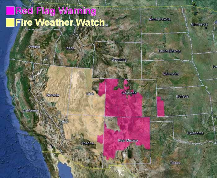
Red Flag Warnings, June 22, 2013

fire Red Flag Warnings, June 22. 2013
Red Flag Warnings, June 22. 2013 (click to enlarge)

Red Flag Warnings and Fire Weather Watches for enhanced wildfire danger have been issued by the National Weather Service for areas in Colorado, New Mexico, Kansas, Utah, Arizona, and Nevada.

****

The Red Flag Warning map above was current as of 11:50 a.m. MDT on Saturday. Red Flag Warnings can change throughout the day as the National Weather Service offices around the country update and revise their forecasts. For the most current data, visit this NWS site.

Colorado: East Peak Fire

(UPDATE at 8:30 a.m. MDT, June 25, 2013)

There was no major change in the East Peak Fire over the last 24 hours. Below is a Monday evening update from the Incident Management Team:

In spite of high winds, low humidity and critical fuel conditions, growth on the East Peak Fire was minimal and containment increased to 50%. The estimated size of the fire is 13,388 acres. Due to the wind, helicopters were grounded for most of the day. Despite the challenge of high winds, firefighters made progress in mop up and patrolling the fire perimeter and engine crews ensured structure protection. Mop up and patrol will continue for the overnight shift and into tomorrow. Resources continue to arrive, totaling in 631 personnel assigned to this fire.

****

(UPDATE at 8:25 a.m. MDT June 24, 2013)

Under overcast skies on Sunday there was not much change in the East Peak Fire. It was most active on the west and southeast sides and grew by a few hundred acres, bringing its total to about 12,800 acres.

****

(UPDATE at 8:55 p.m. MDT, June 23, 2013)

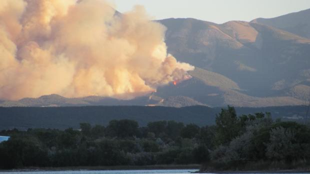
East Peak Fire
East Peak Fire, unknown date. Photo by Don Degman

Below is an update from the Incident Management Team at about 6:30 p.m. Sunday:

Overcast conditions set up a successful burnout operation on the East Peak Fire today. ““I’’m very pleased with the results of the burnout today. It went really smoothly”,” said Craig Beckner, Operations Section Chief. Aided by favorable winds from southeast, the burnout operation helped to reinforce control line on the southern boundary of the fire.

On the western perimeter, a very large airtanker made a retardant drop that will assist firefighters with constructing handline tomorrow in very steep terrain.

Cooler conditions and overcast skies kept the fire from gaining much acreage and is now at 12,996 acres.

Mandatory evacuations are still in effect for a large portion of the fire area. However, Huerfano County Sheriff, Bruce Newmann, started letting residents back into some closure areas.

Air Tanker 910, a DC-10, dropped 46,400 gallons of retardant on the fire today in four sorties.

****

(UPDATE at 8:24 a.m. MDT, June 23, 2013)

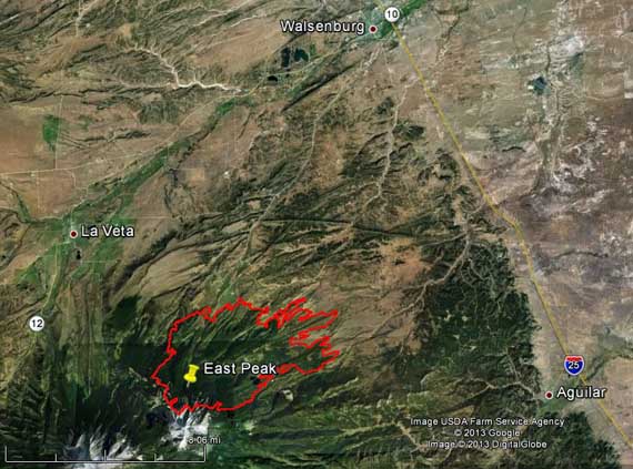
Map of East Peak Fire, 2 a.m. MDT, June 23, 2013

The East Peak Fire in southern Colorado grew by about 1,000 acres Saturday, bringing its total to approximately 12,000 acres. It is 11 miles southwest of Walsenburg and about 9 miles west of Aguilar.

There are an estimated 300 properties within the evacuation area. An American Red Cross shelter has been established at the John Mall High School in Walsenburg, Colorado. Evacuated animals, large or small can be taken to the Fairgrounds in La Veta, Colorado.

The Incident Management Team reports that 10 “primary” structures have burned along with 4 outbuildings.

****

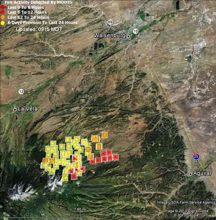
Map of East Peak Fire
Map of East Peak Fire, showing heat detected by a satellite at 11:05 p.m. MDT, June 21, 2013. (click to see a larger version)

(UPDATE at 5:15 p.m. MDT, June 22, 2013)

The incident management team running the East Peak Fire sent this Tweet at 3:21 p.m. Saturday:

****

(Originally published at 9:47 a.m. MDT, June 22, 2013)

The East Peak fire has burned about 11,000 acres in the southern part of Colorado 25 miles from the New Mexico border. As you can see from the map above, at 11 p.m. Friday night it was approximately 7 miles west of Aguilar and about 10 miles southwest of Walsenburg, according to the data provided by the satellite. The location of the square icons can be as much as a mile in error.

Rocky Mountain Type 2 Incident Management Team C, with Incident Commander Jay Esperance, assumed command of the Fire at 6:00 pm, Friday, June 21.

Map of Colorado wildfires, June 22, 2013

Map of Colorado fires June 22, 2013. Wildfire Today.The map shows the large wildfires in Colorado that are still active and spreading, and the acres burned for each. The Papoose and West Fork fires have now been combined into the “West Fork Complex”.  We have more information about the West Fork Complex and the East Peak Fire.