Dixie Fire grows rapidly, prompting more evacuations

Expands to 181,000 acres

9:35 a.m. PDT July 24, 2021

Dixie Fire map
Map of the Dixie Fire. The white line was the perimeter at 2:30 a.m. PDT July 24, 2021. The green line was the perimeter about 24 hours before. The red dots represent heat detected by a satellite at 4:00 a.m. PDT July 24, 2021.

The Dixie Fire, six air miles south of Chester, California, was very active Friday, but not as much as on Thursday due to a decrease in wind speeds. While it still created convection columns of smoke topped by white pyrocumulus clouds, they were not as large and the fire did not increase in size as much as in previous days, but it still grew by tens of thousands of acres, expanding to 181,289 acres by Saturday morning.

The east side near Caribou, Twain, and Paxton, as well as the nearby Fly Fire at Kiddie, spread one to two miles further east. The Fly Fire is a new fire that started Thursday.

To see all articles on Wildfire Today about the Dixie Fire, including the most recent, click HERE.

Wednesday night firefighters began a firing operation north of the fire to create a burned area south of Lake Almanor intended to stop the northward progress of the fire. They are working from a road system south of and parallel with Highway 89, starting from Canyondam working west and then plan to circle around the northwest side of the fire toward Butte Meadows. The prescription for the firing calls for it to be done at night, conditions that make it easier for firefighters to control the fire intensity. This is similar to conducting a prescribed fire. By early Saturday morning crews had initiated firing along approximately nine miles of roads, working toward the west-northwest. The project can be seen on the map above, appearing as a strip of white lines south of Highway 89.

Dozer assisting firefighters
Dozer assisting firefighters on a firing operation, July 22, 2021. InciWeb.

The fire has been split into two zones organizationally, East and West, each with its own Incident Management Team.

The weather forecast for Saturday calls for warmer and drier conditions with relative humidities in the upper single digits and temperatures ranging from 80 to 100 degrees depending on the elevation. Wind speeds will be in the 10 to 15 mph range. The very low humidity, high temperatures, and wind, combined with the very low fuel moistures will present difficult conditions for firefighters.


4:56 p.m. PDT July 23, 2021

Dixie Fire map the white line was the perimeter 330 a.m. PDT July 23, 2021
Dixie Fire map. The red dots represent heat detected by a satellite at 3:30 a.m. PDT July 23, 2021. The white line was the perimeter 6 to 18 hours earlier.

The 143,000-acre Dixie Fire south of Chester, California was extremely active Friday afternoon, at times creating multiple smoke columns topped with pyrocumulus clouds. The growth on Thursday and Friday has been described as explosive.

The fire is being fought by 70 hand crews, 355 engines, and 31 helicopters for a total of 4,005 personnel.

Dixie Fire detected on radar
The Dixie Fire smoke columns were detected by radar at 5:31 p.m. PDT July 23, 2021.

Thursday evening the Dixie Fire was 6 air miles south of Chester, 14 miles northeast of Paradise, and 25 miles northeast of Oroville. A new fire nearby, the Fly Fire, was 4 miles north of Quincy.

Dixie Fire
The Dixie Fire as seen from Sloat Mountain, looking northwest at 3:56 p.m. PDT July 23, 2021.

Evacuations are occurring in three counties, Butte, Plumas, and Tehama. Evacuation notices for Butte and Pluma are posted at a website maintained by the counties. Tehama also recently established a similar service.

Below is a summary of the evacuation notices published by Plumas County at 1 p.m. PDT July 23, 2021. Keep in mind it is a very dynamic situation and changes occur frequently.

Tamarack Fire spreads east across Hwy. 395 in Nevada

Burns more than 65,000 acres

12:26 p.m. PDT July 24, 2021

Tamarack Fire map
Tamarack Fire map. The white line was the fire perimeter at 9:30 p.m. PDT July 23, 2021. The green line was the perimeter approximately 24 hours before. The red dots represent heat detected by a satellite at 4:00 a.m. PDT July 24, 2021.

Calmer winds Friday allowed firefighters on the 65,152-acre Tamarack Fire 14 miles southeast of South Lake Tahoe to make progress, especially on the north and northeast sides of the fire. On Saturday they are expecting similar conditions which should allow additional containment efforts.

The Incident Management Team recorded a very informative video Saturday morning, featuring Operations Section Chief Pat Seekins.

Tamarack Fire
Tamarack Fire July 23, 2021. InciWeb.

1:40 p.m. PDT July 23, 2021

Tamarack Fire map
Tamarack Fire map. The white line was the perimeter at 7:25 p.m. PDT July 22, 2021. The green line was the perimeter about 24 hours before.

On Thursday the Tamarack Fire, pushed by strong winds, spread east across US Highway 395 in spite of firefighters’ best efforts to stop it at the highway with a burning operation. Within a few hours it burned about 2,500 acres east of the highway, becoming well established on that side.

On Tuesday the fire burned from California into Nevada. A mapping flight at 7:25 p.m. Thursday determined it had grown by about 7,000 acres to a total of 58,417 acres.

It crossed 395 a mile or two north of Holbrook Junction, which is the intersection with Highway 208. Friday afternoon the FlightRadar24 service showed a great deal of air tanker activity southeast of the junction. That would indicate that the fire had spread into the area between 208 and Topaz Lake, but it remains to be confirmed.

There are 1,353 personnel working on the fire and more resources are on order. Firefighting operations continue around the clock, with additional crews added to the night shift. Night operations include structure protection and firing operations when conditions are suitable.

Firefighters have continued to keep the fire south of Highway 88, which with Highway 89 were both closed in the fire area Friday morning to all traffic except incident personnel. A portion of 395 was also closed Friday morning for firefighter and public safety.

On Thursday an additional 1,369 people were evacuated primarily from the Hwy 395 corridor, bringing the total number of those evacuated to 2,439.

The Incident Management Team has created an interactive map that is intended to have evacuation information for residents.

Bootleg Fire grows to nearly 400,000 acres

27 miles northeast of Klamath Falls, Oregon

2:02 p.m. PDT July 22, 2021

Bootleg Fire map
Bootleg Fire map. The white line was the perimeter at 8 p.m. PDT July 21, 2021. The red dots represent heat detected by a satellite at 3:48 a.m. PDT July 22, 2021.

The Bootleg Fire 27 miles northeast of Klamath Falls, Oregon grew Wednesday to 399,359 acres in spite of the higher humidity and reduced wind speeds. The less extreme fire behavior gave firefighters the opportunity to construct and improve firelines. The forecast for Thursday afternoon should enable those activities to continue, but a warming and drying trend is expected into the weekend.

As of July 21, $41.5 million has been spent on the fire and 184 structures have been destroyed.

“Fire crews and support personnel have made significant progress in containing this fire in the last few days.”said Joe Prummer, Incident Commander trainee of Pacific Northwest Incident Management Team 2. “However, we still have a long road ahead of us to ensure the safety of the surrounding communities.”

Bootleg fire
July 21, 2021. InciWeb photo.

As the need for night operations on the southern zone decreases, those resources are being moved to the day shift or sent home for rest as they time-out.

The latest evacuation information can be found at a website maintained by Klamath and Lake Counties.

Satellite photo fires in CA WA OR

Resources assigned to the fire Wednesday evening included 49 hand crews, 199 fire engines, and 20 helicopters for a total of 2,268 personnel.

Dixie Fire reaches Butt Valley Reservoir

Continues to spread north and east, 8 miles south of the Chester Airport

 Updated at 9:39 a.m. PDT July 22, 2021

Map of the Dixie Fire
Map of the Dixie Fire. The white line was the perimeter at the end of the day on July 21. The red dots represent heat detected by a satellite at 3:48 a.m. July 22, 2021.

The Dixie Fire in Northern California burned up to the Butt Valley Reservoir and grew closer to Highway 89. A mapping flight Wednesday night found that it was 5 miles southwest of Lake Almanor, 8 miles south of the Chester Airport, and was still 13 miles northeast of Paradise.

We have two maps of the Dixie Fire today. The wide view or vicinity map, is above, and below is a zoomed-in version, plus a satellite photo.

(To see all articles on Wildfire Today about the Dixie Fire, including the most recent, click HERE.)

CAL FIRE said Thursday morning that it has burned 103,910 acres, an increase of about 12,000 acres in 24 hours. Strong winds Wednesday night helped keep the fire active. The agency’s website for fire information was down for a while at 8:51 a.m. Wednesday but was back up later.

Satellite photo Dixie Fire
Satellite photo of smoke from the Dixie Fire at 6:46 p.m. July 21, 2021. NASA, GOES 17.

Evacuations are in effect — the Butte County Sheriff’s Office has a link to the details.

Eight structures have been destroyed. Resources assigned Wednesday evening including 22 helicopters, 337 engines, 83 dozers, 55 water tenders, and 71 crews for a total of 3,919 personnel.

Map of the Dixie Fire
Map of the Dixie Fire. The white line was the perimeter at the end of the day on July 21. The red dots represent heat detected by a satellite at 3:48 a.m. July 22, 2021.

Incident Management Team releases information about the origin of the Tamarack Fire

The fire crossed US Highway 395 Thursday afternoon

9:10 p.m. PDT July 22, 2021

Tamarack Fire map
Map of the Tamarack Fire July 22, 2021 before it burned across Hwy. 395. The time the data was current is not certain, but may have been early afternoon PDT July 22, 2021.

On Tuesday the Tamarack Fire burned from California into Nevada, and Thursday afternoon it made another big push to the east and hit US Highway 395 with some intensity north of Holbrook Junction. At first it was just a spot fire across the road but it grew very rapidly and at 4:10 p.m. aerial firefighters estimated it had burned 2,500 acres east of the highway.

Several large air tankers including a DC-10 Very Large Air Tanker assisted firefighters on the ground in an attempt to stop the spread of slopover across the highway.

Tamarack Fire crosses Hwy 395
Tamarack Fire crosses Hwy 395 in the afternoon of July 22, 2021. IMT photo.
Tamarack Fire
Tamarack Fire as seen from Hawkins Peak, looking ENE at 9:20 p.m. PDT July 22, 2021.

The Incident Management Team has created an interactive map that at some point is supposed to have evacuation information for residents.


2:32 p.m. July 21, 2021

Tamarack Fire
Tamarack Fire, looking northeast from Hawkins Peak at 2:17 p.m. PDT July 21, 2021.

The Incident Management Team that is suppressing the Tamarack Fire posted on InciWeb their view about how the fire was managed during the first 12 days after it started. The statement was presumably approved by the U.S. Forest Service, the jurisdiction responsible for suppressing and/or managing the fire which was on the Humboldt-Toiyabe National Forest.

“The Tamarack Fire on the Humboldt-Toiyabe National Forest was discovered on July 4,” the statement says. “At the time, 23 other lightning fires were burning.  It was a single tree burning in the Mokelumne Wilderness on a rocky ridgetop with sparse fuels and natural barriers to contain it. The steep, rugged, and remote terrain presented challenges to safely suppress this wilderness fire.  With several higher priority fires in the area and due to the remote location, the sparse fuels and natural barriers, and the concern for firefighter safety, the decision was made to monitor the Tamarack Fire.”

“The Tamarack Fire was monitored daily via air and fire cameras and exhibited very little fire behavior until Friday, July 16 when fueled by extreme winds and low humidity, it progressed rapidly downslope and spread throughout the evening. With this rapid change in the fire, fire resources were dispatched on Friday, July 16. Additional firefighting resources were also ordered, including very Large Air Tankers (VLAT), Single Engine Airtankers (SEATS) and helicopters.”

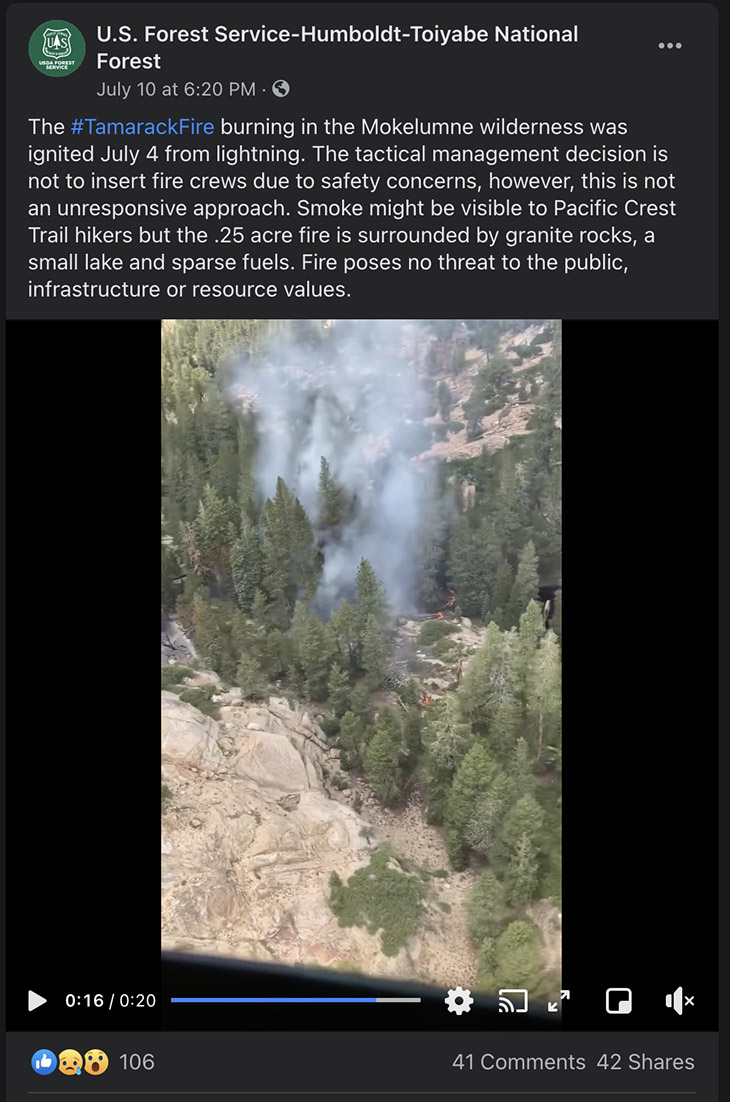
Below is a still image of a Forest Service Facebook post with a video of the fire when it was a quarter acre on July 10, six days after it started. “Fire poses no threat to the public, infrastructure, or resource values,” they wrote.

Tamarack Fire Facebook July 10, 2021

The Tamarack Fire spread further east on Tuesday, crossing the state line from California into Nevada. From its origin, it has now spread 15 miles northeast and 10 miles to the north, burning 10 structures and approximately 40,000 acres.

To see all articles on Wildfire Today about the Tamarack Fire, including the most recent, click HERE.