Randy Moore selected as new Chief of the U.S. Forest Service

Randy Moore Forest Service
Randy Moore, 20th Chief of the U.S. Forest Service.

Agriculture Secretary Tom Vilsack today announced that Randy Moore will serve as the 20th Chief of the U.S. Department of Agriculture’s Forest Service.

“Randy Moore has been a catalyst for change and creativity in carrying out the Forest Service’s mission to sustain the health, diversity and productivity of the nation’s forests and grasslands to meet the needs of present and future generations,” said Secretary Vilsack. “In his role as Regional Forester, Randy has been a conservation leader on the forefront of climate change, most notably leading the Region’s response to the dramatic increase in catastrophic wildfires in California over the last decade. His proven track record of supporting and developing employees and putting communities at the center of the Forest Service’s work positions him well to lead the agency into the future at this critical time in our country.”

Upon swearing in, Moore will serve as the first African American to hold the role of Chief of the Forest Service.

Current Forest Service Chief Vicki Christiansen will step down from her role on July 26. Chief Christiansen and Regional Forester Moore will continue to collaborate on an intentional leadership transition between now and then as the Forest Service gears up for a tough summer of predicted elevated fire activity across the Western United States.

Background:

Randy Moore has been serving as Regional Forester in the Pacific Southwest Region in California since 2007 where he has responsibility for 18 national forests, covering one-fifth of the state on 20 million acres of land. Additionally, he oversees State and Private Forestry programs in Hawaii and the U.S. affiliated Pacific Islands.

Previously, Moore served as the Regional Forester for the Eastern Region, headquartered in Milwaukee, Wisconsin, for five years.

Moore started his career in conservation in 1978 with USDA’s Natural Resources Conservation Service in North Dakota. His Forest Service career began on the Pike and San Isabel National Forests in Colorado and the Comanche and Cimarron National Grasslands in Kansas. He served as Deputy Forest Supervisor on the National Forests of North Carolina and the Mark Twain National Forest in Missouri before serving as Forest Supervisor of the Mark Twain National Forest. Moore also has national-level experience in Washington, D.C., serving as acting Associate Deputy Chief for the National Forest System and the National Deputy Soils Program Manager.

Moore earned a bachelor’s degree in plant and soil science from Southern University in Baton Rouge, Louisiana. He and his wife Antoinette have two sons, a daughter-in-law, and two grandsons.

Thanks and a tip of the hat go out to Jim, Shannon, and Tom.

Update on Rafael Fire southwest of Flagstaff

The fire has grown to over 77,000 acres

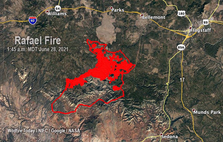
Rafael Fire, June 28, 2021 map
Rafael Fire map, June 28, 2021

Firefighters have made progress on the 77,102-acre Rafael Fire in Arizona. In a video briefing Monday morning Operations Section Chief Rocky Gilbert said due to the firing operations completed on the northeast side there is no longer a threat to the city of Flagstaff.

Their map shows that at least half of the perimeter is held fire line (the black line), and officially the Incident Management Team reports that the fire is 48 percent contained. There is still much work to be done on the northwest and south sides. The map below of heat detected by a satellite Sunday night shows quite a bit on the northwest side, but almost none on the southern perimeter.

Rafael Fire map
The red areas on the map represent heat detected by satellites on the Rafael Fire at 1:45 a.m. MDT June 28, 2021. The red line was the perimeter at 1:45 a.m. June 28.

The Rafael Fire is:

      • 6 miles south of Interstate 40
      • 13 miles southwest of Flagstaff
      • 7 miles west of Highway 89A, and
      • 10 miles northwest of Sedona
Firefighters on the Rafael Fire conduct a burnout June 27, 2021. Photo by Michelle Herrin.

Extreme heat in the Northwest brings elevated danger of wildfires

Many areas will experience temperatures above 100 degrees for the next several days

Hot Dry Windy Index weather fire wildfire
Hot Dry Windy Index, central Oregon.

The extreme heat that is gripping the Northwest this week is establishing weather conditions that are favorable for wildfires to spread more rapidly than usual. The Hot Dry Windy Index for Central Oregon on Monday and Tuesday is far above the 95th percentile. Other locations in Oregon and Washington also show the HDWI at high levels this week, generally above the 90th percentile and higher. (We first wrote about the HDWI in 2019.)

Many areas in the Northwest will have high temperatures above 100 degrees for the next several days. Here is an excerpt from an article published Monday at Oregon Public Broadcasting:

Seattle, Portland and other cities broke all-time heat records over the weekend, with temperatures soaring well above 100 degrees Fahrenheit. Forecasters said Monday would be worse, with the mercury possibly hitting 110 F in Seattle and 115 F in the Portland area before it begins to cool Tuesday.

In Eugene, the U.S. track and field trials were halted Sunday afternoon and fans were asked to evacuate the stadium due to extreme heat. The National Weather Service said it hit 110 F in Eugene, breaking the all-time record of 108 F. Portland reached 112 F Sunday, breaking the all-time temperature record of 108 F, which was set just a day earlier.

The temperature hit 104 F in Seattle. The weather service said that was an all-time record for the city better known for rain than heat and was the first time the area recorded two consecutive triple digit days since records began being kept in 1894.

The heat wave stretched into British Columbia, with the temperature in Lytton, a village in the Canadian province, reaching 115 F Sunday afternoon, marking a new all-time high recorded in Canada.

Red Flag Warnings June 28, 2021 fire wildfire
Red Flag Warnings June 28, 2021.

Red Flag Warnings are in effect Monday for a number of areas in California, Washington, and Oregon. The Fire Weather Watch areas on the map above for locations in California and Nevada are for thunderstorms and strong outflow winds Tuesday afternoon through late Tuesday night.

So far the extreme heat has not led to large fires in Washington and Oregon. Monday’s Situation Report does not include any that are less than 95 percent contained. However the 1,446-acre Lava Fire near Weed, California, 37 miles south of the Oregon Border, bears watching. Started from lightning on June 25, it will be subject to winds gusting to 26 mph Monday afternoon.

Lava Fire under a Red Flag Warning Monday afternoon

Monday morning it had burned 1,446 acres 3 miles east of Weed, California

Updated at 9:16 p.m. PDT June 28, 2021

Lava Fire
Lava Fire, from the Antelope Yreka1 camera. Looking southeast toward Mt. Shasta at 3:32 p.m. PDT June 28, 2021. Before it crossed Highway 97.

The Lava Fire that was east of Weed, California Monday morning is much larger than it was after being pushed north in the afternoon by winds gusting from 26 to 33 mph. It crossed Highway 97 and kept going. It is difficult to tell how far north it ran until the smoke clears or an infrared mapping aircraft can collect some intelligence overnight.

(To see all articles on Wildfire Today about the Lava Fire, including the most current, click HERE.)

The weather forecast predicts the wind speed will decrease sharply after 10 p.m. Monday night to around 5 mph, and overnight will come out of the east-southeast, then east. Tuesday morning the direction will be variable but will become established in the afternoon to come from the east at 13 to 16 mph gusting to 24 mph. This could spread the fire to the west unless by then firefighters can contain the west flank.

CAL FIRE is mobilizing large numbers of firefighting resources to assist in battling the fire, which burned out of the Shasta-Trinity National Forest after it crossed Highway 97.

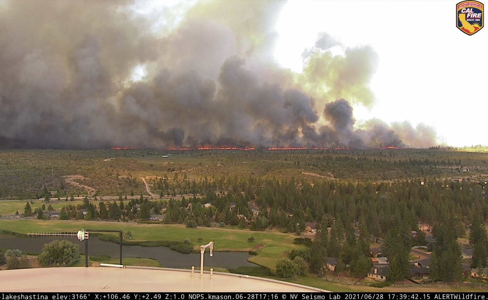
Lava Fire
West flank of the Lava Fire, north of Highway 97, at 5:39 p.m. June 28, 2021. Looking east-southeast from the Lake Shastina camera.

Updated at 4:51 p.m. PDT June 28, 2021

A person on Twitter who follows wildland fires closely, CA Fire Scanner,  learned from listening to the Lava Fire’s radio traffic that the fire, spreading rapidly north, has crossed Highway 97 and is well established on the north side.

Approximately five air tankers are working the fire, including Tanker 912, a DC-10.

However this afternoon’s fire run turns out, the weather forecast for Monday night also looks troublesome. After 10 p.m. the wind is expected to shift to come out of the southeast and then east. The speed should decrease from the 29 mph gusts in the afternoon to 5 to 8 mph through the night. This wind direction could push the fire west, threatening communities west of the fire.

smoke from Lava Fire
Satellite photo, smoke from Lava Fire at 4:21 p.m. PDT June 28, 2021.

Continue reading “Lava Fire under a Red Flag Warning Monday afternoon”

Lava Fire burns northwest of Mt. Shasta in Northern California

Three miles northeast of Weed

Updated at 4:47 p.m. PDT June 27, 2021

Lava Fire Map
Map showing the perimeter of the Lava Fire. Mapped by a USFS Cobra Firewatch helicopter at 1:44 p.m. PDT June 27, 2021.

The Lava Fire three miles east of Weed, California was mapped by a US Forest Service Cobra Firewatch helicopter at 1:44 p.m. PDT Sunday and determined that the fire had burned 410 acres.

(To see all articles on Wildfire Today about the Lava Fire, including the most recent, click HERE.)

The high temperature at a weather station northwest of the fire at about the same elevation recorded a high temperature as of 3:53 p.m. of 93 degrees, but still appeared to be rising. The relative humidity in the afternoon was in the teens, the wind speed was 2 to 5 mph, and the direction, as predicted, was all over the place.

Lava Fire smoke convection column pyrocumulus
Lava Fire, smoke column topped by pyrocumulus cloud, June 27, 2021. InciWeb photo.

Sunday afternoon the Lava Fire was putting up an impressive pyrocumulus-topped convection column. The light wind allowed the column to build directly over the fire.

On Monday that breeze will be replaced in the afternoon by strong winds out of the south at 17 mph gusting to 28 while the temperature rises to 96 degrees with 15 percent relative humidity…. a recipe for significant fire growth unless firefighters can get a line around the fire before noon.


Updated at 8:12 a.m. PDT June 27, 2021

map Lava Fire
3-D map showing the APPROXIMATE perimeter of the Lava Fire at 3:18 a.m. PDT June 27, 2021. Looking east.

The Lava Fire near Weed, California was active all night Saturday. A satellite overflight at 3:18 a.m. Sunday showed that it had spread approximately 1 mile further to the south in the previous 12 hours making the overall length about two miles. (See the map above)

Saturday evening the Incident Management Team reported it had burned 220 acres. The heat signatures detected by the satellite at 3:18 a.m indicated that it had grown to at least 400 acres.

Continue reading “Lava Fire burns northwest of Mt. Shasta in Northern California”

CNN — pay disparity between Federal firefighters and other jurisdictions is “staggering”

Briefing on Springs Fire
Firefighters gather for a briefing on the Springs Fire on the Boise National Forest near Banks, Idaho, August 12, 2020. Kari Greer photo for U.S. Forest Service.

CNN has joined the chorus of news organizations covering the deteriorating status of Federal wildland firefighting crews. A lengthy article published today describes the pay discrepancy between federal crews and personnel in other jurisdictions as “staggering”.

pay disparity federal firefighters
From CNN

The CNN reporters interviewed several current and former federal wildland firefighters. Aaron Humphrey, who is known as “Hump”, quit after 25 years, leaving the position of Superintendent of the Eldorado Hotshots, becoming “just the latest mentally fried, underpaid hotshot veteran to leave, at a time when California wildfires are at their worst.”

From CNN:

I needed to be home with my family,” Hump told CNN. “The level of stress I was bringing home (from massive fires) — I didn’t even recognize myself anymore.”

Hump, a married father with three children — ages 12, 10 and 8 — now works for Pacific Gas and Electric, as a lead on the utility’s safety infrastructure protection team.

Hump says he’s paid at least $40,000 more annually than what he made before as a hotshot supervisor. The money comes with peace of mind, as he now attends all of his children’s events, even coaching some flag football.

CNN also interviewed a Captain on the El Dorado Hotshots, D.J. McIlhargie.

“I have five irons in the fire right now,” McIlhargie told CNN. “I’m looking for something that will work for my family more. And my wife knows that I’m tired of waiting for the Forest Service to give me a commensurate salary to what other departments pay.”

The father of two boys, 7 and 10, McIlhargie lives an hour outside Sacramento. He described feeling “wiped out” and “frustrated” by battling the recent streak of super fires.

McIlhargie, 39, says there are just not enough firefighters to take on massive blazes such as the ones that ravaged Northern California last year.

The article also states “15 California Interagency Hotshot Crews don’t have enough members to activate as a full firefighting unit. CNN obtained a CIHC document that confirms that number.”

Four Senators, Dianne Feinstein, Alex Padilla, Kyrsten Sinema, and Steve Daines, wrote a letter asking a subcommittee of the Appropriations Committee to include language in its fiscal year 2022 funding bill directing the Office of Personnel Management to implement a plan to raise federal firefighter pay. They are requesting that the following language be included in the bill:

“The Director of the Office of Personnel Management ….not later than 180 days after the date of enactment of this Act, submit to Congress a plan to establish comparable rates of pay payable to wildland firefighters employed by the Federal Government, as compared to the rates of basic pay payable for similar work by wildland firefighters employed by State and local governments in each jurisdiction identified by the Departments of Interior and Agriculture…Not later than 1 year after the date of enactment of this Act, fully implement any necessary regulation or OPM authorized changes to establish the new position classification and qualification standards—for employees across the Federal Government, the job responsibilities of whom involve wildland firefighting; which shall reflect the comparable rates of basic pay established in the plan submitted.”


Opinion

When CNN, NBC, LA Times, and USA Today point out that the pay structure of Federal wildland firefighters is far out of line with what it should be, maybe there is a problem that needs addressing. Senators write letters and ask softball questions of Forest Service officials testifying in hearings, but nothing is getting done to improve the working environment of Federal wildland firefighters.

They need a new Wildland Firefighter job series with pay commensurate with those in agencies and organizations that are poaching trained and experienced employees from the Federal land management agencies.

Thanks and a tip of the hat go out to Richard.