U.S. Forest Service Chief Vicki Christiansen to retire

She plans to leave in August

Senate hearing, Subcommittee on Interior, Environment, and Related Agencies hearing, May 26, 2021 Vicki Christiansen
US Forest Service Chief Vicki Christiansen, at Senate Appropriations Subcommittee hearing, May 26, 2021.

Vicki Christiansen announced today her intention to retire from her position as Chief of the U.S. Forest Service. In addition to issuing a news release, she recorded what the Forest Service calls a “selfie video.” (below)

At times during the three-minute video she appeared to be emotional, taking a pause to collect herself. But she got right to the point. Here is how it began:

Hi everyone, it’s Chief Vicki Christiansen. Today, I’m going to share a personal decision that I have made together with my family. I will be retiring from USDA Forest Service in August. Please know what a difficult and emotional decision this is for me. I’ve been a wildland firefighter, a professional forester and a land manager for the last 40 years, and my personal passion is connecting people with their natural resources and serving at the Forest Service for the past 11 years has allowed me to do that in partnership with all of you. Serving with you has been a really special privilege, and it’s the best capstone that I could ever ask for my career.

From Wikipedia:

Christiansen worked as a firefighter in Washington for 26 years, eventually serving as the Washington State Forester. She then served as the Arizona State Forester from 2009 to 2010. She joined the United States Forest Service in 2010 as the acting director of legislative affairs before serving as deputy director of fire and aviation management. In 2012, she served as acting regional forester for the Northern Region, which covers 25 million acres across five states and includes 12 national forests.

Christiansen was named the 19th chief of the Forest Service in October 2018.

Chief Christiansen said she “has been working with Secretary of Agriculture Tom Vilsack to plan her retirement for several months.” He is expected to nominate her successor later in June.

Chief Christiansen received mixed reviews during the last several months. She has been criticized for her meek appearances before Congressional committees, failing to be a strong advocate to impress upon the legislators that inadequate funds are being appropriated for the Forest Service, making it impossible to make adequate progress in managing hazardous fuels, prescribing burning, and recruiting and retaining skilled firefighting personnel.

Chief Vicki Christiansen 2021 update from Forest Service on Vimeo.

Below is the complete transcript of the video, “lightly edited for clarity” by the US Forest Service:


“Hi everyone, it’s Chief Vicki Christiansen. Today, I’m going to share a personal decision that I have made together with my family. I will be retiring from USDA Forest Service in August. Please know what a difficult and emotional decision this is for me. I’ve been a wildland firefighter, a professional forester and a land manager for the last 40 years, and my personal passion is connecting people with their natural resources and serving at the Forest Service for the past 11 years has allowed me to do that in partnership with all of you. Serving with you has been a really special privilege, and it’s the best capstone that I could ever ask for my career.

“But, the time has come for me to spend more time with my family: my dear mother, who will turn 90 in a few months, my—of course—my children and my grandchildren. You know, they live a continent away in the Pacific Northwest, and I just need to be closer to them. And they have supported me so much throughout my entire career. It’s time for me to give back and to support them.

“I’ve chosen this moment, in part, because I think it’s the best time. There’s never a perfect time. I’d like to get so much more done with you and for you, but there are great leaders that are ready to step up, and in the coming days or weeks Secretary Vilsack will be announcing the next Chief. And I’ll stick around; I’ll spend a few weeks to do a transition with the new Chief once they’re in place. We want you all to know how much a good transition means for the Forest Service and USDA.

“So, think about all that we have accomplished in the last three years: coping with a global pandemic and horrendous fire years, the good traction that has been made in improving forest conditions and really setting the stage to do even more of that work with shared stewardship, and, of course, changing our culture for the better by naming and living our values through This is Who We Are.

“So, thank you for your support and thank you for your incredibly hard work. I am very proud to be one of you and this great mission of the Forest Service will be in my heart forever. It’s been an extreme honor and a great privilege to serve as your Chief.

“Thank you.”

End of transcript.

To see all articles on Wildfire Today tagged “Victoria Christiansen”, click here.

Thanks and a tip of the hat go out to Riva, SR, and Kelly.

Intanko Fire prompts evacuations east of Yuba City, California

A portion of Beale Air Force Base was evacuated

Updated at 8:50 p.m. PDT June 8, 2021

CAL FIRE reports that the spread of the Intanko Fire 15 miles east-southeast of Yuba City, California has been stopped. It was mapped at 950 acres.


Updated at 5:06 p.m. PDT June 8, 2021

Intanko Fire
Intanko Fire June 8, 2021. As seen from KCRA 3 helicopter at approximately 4:30 p.m. On the left can be seen a portion of a fire that burned on the Beale Air Force Base June 5, 2021.

At 4:51 p.m. Tuesday CAL FIRE reported that the Intanko Fire 15 miles east-southeast of Yuba City, California had grown to 500 acres and was moving north toward Chuck Yeager Road.

Intanko Fire
Intanko Fire at 5:01 p.m. June 8, 2021, as seen from the Penn Valley cam. Looking southeast.


3:47 p.m. PDT June 8, 2021

map Intanko Fire
Location of Intanko Fire, 3 p.m. PDT June 8, 2021

A vegetation fire 15 miles east-southeast of Yuba City, California prompted evacuations Tuesday afternoon. At least one home was destroyed in the fire that was reported a little before 2 p.m. PDT, 32 miles north of Sacramento.

At 3:24 CAL FIRE reported it had burned 300 acres.

Intanko Fire June 8, 2021
Intanko Fire June 8, 2021. CAL FIRE photo.

The fire started south of Beale Air Force base. The AFB Fire Chief ordered all housing residents east of East Garryanna that were in base housing to evacuate to the elementary school parking lot.

On June 5 there was another vegetation fire on the southeast portion of the base.

Intanko Fire
Intanko Fire as seen from the Penn Valley cam at 2:59 p.m. PDT June 8, 2021.
Intanko Fire June 8, 2021
Intanko Fire June 8, 2021. CAL FIRE photo.

Spread of Telegraph Fire southwest of Globe, AZ slows

Updated at 9:51 a.m. MDT June 10, 2021

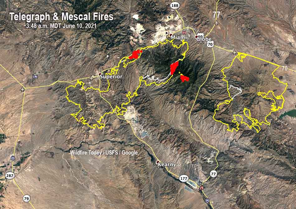
map Telegraph & Mescal Fires
The red areas represent heat detected on the Telegraph & Mescal Fires by a satellite at 3:48 a.m. MDT June 10, 2021. The yellow line was the perimeter mapped by an aircraft at 9:15 p.m. MDT June 9, 2021. The white line was the perimeter about 24 hours before.

Firefighters on the Telegraph Fire have completed defensive burning operations around the communication towers on Pinal Peak one to two miles east of the main fire. South of Miami andn Claypool they are using dozers to construct several indirect contingency fire lines, and are burning out from some of the lines. On Thursday, for the first time a 15-mile stretch of fire perimeter west of Pinal Peak will be staffed by firefighters. Aerial ignitions are being conducted on the north side of the Pinals to bring fire slowly down the slopes in an attempt to lessen the severity of the fire effects. The fire has burned 85,335 acres.

Good progress is being made on the Mescal Fire, which was mapped at 72,250 acres Wednesday night.


Updated 8:48 a.m. MDT June 9, 2021

Mescal Fire, June 8, 2021
The San Carlos hand crew and the Bear Jaw Type 2IA Crew teamed up on a large spot fire on the west flank of the Mescal Fire June 8, 2021. BLM photo by Mike McMillan.

The Telegraph and Mescal Fires east of Phoenix continued to grow Wednesday. Both of the fires are near Globe, and are six miles apart separated by Highway 77.

Telegraph
Tuesday night satellites detected heat on Pinal Peak three miles east of the main fire. This could indicate firefighters are using fire to reduce the vegetation around the electronic sites on the mountain. (See the map below.)

The blaze was mapped by an aircraft Tuesday night at 80,822 acres, a 24-hour increase of about 4,000 acres.

Resources assigned include 20 hand crews, 39 engines, and 6 helicopters, for a total of 754 personnel, a 24-hour increase of 457 personnel.

mapTelegraph & Mescal Fires
The red areas represent heat detected on the Telegraph & Mescal Fires by a satellite at 4:06 a.m. MDT June 9, 2021. The yellow line was the perimeter mapped by an aircraft at 8:36 p.m. MDT June 8, 2021. The white line was the perimeter about 24 hours before.

Mescal
The only large concentrations of heat detected on the Mescal Fire Tuesday night by satellites was east of the 700 Road where firefighters are firing out, using the road as a barrier.

The Mescal Fire was mapped by an aircraft Tuesday night at 70,066 acres, an increase of about 3,000 acres.

Resources assigned include 16 hand crews, 25 engines, and 8 helicopters, for a total of 610 personnel, a 24-hour decrease of 49 personnel.

Mescal Fire
Mescal Fire, June 6, 2021. BLM photo by Mike McMillan.

8:52 a.m. MDT June 8, 2021

map Telegraph & Mescal Fires 235 a.m. MDT June 8, 2021
The red areas represent heat detected on the Telegraph & Mescal Fires by a satellite at 2:35 a.m. MDT June 8, 2021. The yellow line was the perimeter at 8:37 p.m. MDT June 7, 2021. The white line was the perimeter about 24 hours before.

The Telegraph and Mescal Fires east of Phoenix, Arizona were both active Monday and Monday night.

Telegraph Fire
Most of the growth of the Telegraph Fire Monday was on the northeast side, south of Miami and Claypool. At 2 a.m. Tuesday it was a half mile to one mile west of Russell Road near the Solitude Tailings Pond, about 2.5 miles west of Highway 60 in Globe.

The incident management team said Tuesday morning that it had burned 71,756 acres, an increase of about 10,000 acres in 24 hours.

Firefighters are protecting values in Top of the World, Superior, Claypool, Miami, and Globe. One of the primary goals is keeping the fire south of U.S. 60.

Mesa Hotshots, on the Telegraph Fire, Superior, AZ
After spending the night shift burning out in Soda Canyon on the Mescal Fire, southeast of Globe, Arizona, the Mesa Hotshots had to make the long drive back over the mountain to Superior, Arizona where they had day sleeping accommodations in the Hotel Magma. The crew was packing their vehicles around 4 pm on June 5, 2021 as they prepared to head back east to work the night shift again. Smoke from the Telegraph Fire is seen in the background. Photo by Tom Story.

Crews are conducting burnout operations where strategically feasible, generally along roads, to remove fuel ahead of the fire .

The fire is expected to continue spreading to the north. Where the perimeter has not been secured on the north side it could fill in some of the gaps where it has not yet reached Highway 60.

Sunday evening the Gila County Sheriff’s Office announced a “GO” notification for all Miami residents west of the Miami town limits. Earlier evacuations had been ordered for the Top-of-the-World Community between Superior and Miami. All of these communities are along US 60.(see map above)

To see all articles on Wildfire Today about the Telegraph and Mescal Fire, including the most recent, click HERE.

Resources assigned to the Telegraph Fire include 7 hand crews, 21 engines, and 4 helicopters for a total of 297 personnel.

Mescal Fire
On Monday the Mescal Fire was far less active than the Telegraph Fire. Many of the strategic firing operations to stop the spread have been successful, including about 8 miles along Highway 70.

Some firefighting resources have been transferred to the Telegraph Fire.

At 2:36 a.m. satellites detected large heat sources in only two areas, the west side about 4 miles east of Highway 77, and on the southeast side about 3 miles west of San Carlos Reservoir.

An overnight mapping flight determined the Mescal Fire had burned about 66,000 acres, a 24-hour increase of about 14,000 acres.

Resources assigned to the Mescal Fire include 18 hand crews, 23 engines, and 7 helicopters for a total of 659 personnel.

Mescal Fire
Burning out on the Mescal Fire, June 6, 2021. BLM photo by Mike McMillan.

Additional evacuations ordered for Telegraph Fire southwest of Globe, Arizona

Evacuation orders still in effect for Mescal Fire

UPDATED at 8:13 p.m. MDT June 7, 2021

Telegraph Fire Arizona Blue Ridge Hotshots
Blue Ridge Hotshots and engines, burning out on the Mescal Fire, June 6, 2021. BLM photo by Mike McMillan.

The Telegraph Fire southwest of Globe, Arizona was active again Monday due to the continuous cured grass and brush, low fuel moistures, and weather conditions — temperature in the upper 90s, 7 percent relative humidity, and 15 mph winds gusting to 24 mph.

At least 3,500 residences are threatened by the fire.

On Monday the fire made runs on the east side near Highway 60 and lofted embers across the road igniting a spot fire north of the Pinal Creek Bridge south of Miami.

Crews are conducting burnout operations where strategically feasible, generally along roads, to remove fuel ahead of the fire .

The fire is expected to continue spreading to the north. Where the perimeter has not been secured on the north side it could fill in some of the gaps where it has not yet reached Highway 60.

At 6 p.m. Monday it had burned about 61,000 acres.

Telegraph Fire Arizona Blue Ridge Hotshots
Blue Ridge Hotshots burning out on the Mescal Fire, June 6, 2021. BLM photo by Mike McMillan.

Resources assigned to the fire include 6 hand crews, 8 engines, 1 dozer, and 5 helicopters for a total of 276 personnel.


1:50 p.m. MDT June 7, 2021

Telegraph Fire
Additional evacuations were ordered for the Telegraph Fire which has been spreading rapidly 27 miles east of Mesa, Arizona, 5 miles southwest of Globe. Sunday evening the Gila County Sheriff’s Office announced a “GO” notification for all Miami residents west of the Miami town limits. Earlier evacuations had been ordered for the Top-of-the-World Community between Superior and Miami. (see map above)

To see all articles on Wildfire Today about the Telegraph and Mescal Fire, including the most recent, click HERE.

All of these communities are along US 60. The next one to the northeast, the direction the fire is moving, which could be threatened later is Claypool, and after that Central Heights-Midland City, and Globe. They were not under evacuation orders as of Monday morning at 10:27 a.m. MDT.

Map of the Telegraph & Mescal Fires
Map of the Telegraph & Mescal Fires. The yellow lines were the perimeters at approximately 11 p.m. MDT June 6, 2021. The white lines were the perimeters about 24 hours before.

Sunday night the incident management team said the Telegraph Fire had burned 41,109 acres. After the overnight mapping flight data has been analyzed that figure will likely increase to more than 56,000 acres. (Update at about 1:50 p.m. MDT June 7: the incident management team revised the size estimate to 56,625 acres.)

The Southwest Area Type 1 Incident Management Team led by Incident Commander Dave Bales, assumed command of the Telegraph Fire early Sunday morning and additional resources continue to be assigned to the fire.

The fire was reported around 1:30 pm Friday, June 4; its cause is under investigation.

Mescal Fire
The Mescal Fire is 13 miles east of the Telegraph fire, 9 miles southwest of Globe. Firefighters have been conducting strategic firing operations north of San Carlos Reservoir and east of Cutter along US Highway 70.

Evacuation orders were previously issued for Coyote Flats, Peridot Heights, the San Carlos High School Area, and all residents along Route 3.

Air tankers and helicopters are being utilized extensively to support firefighters on the ground as needed.

Helicopter 28HX Telegraph fire
Helicopter 28HX lands at the Superior Helibase late in the afternoon after doing bucket work on the Telegraph Fire June 5, 2021. Photo by Tom Story.

Sunday evening the incident management team said the Mescal Fire had burned 49,631 acres. After the overnight mapping flight data has been analyzed that figure will likely increase to more than 52,000 acres. (Update at about 1:50 p.m. MDT June 7: the incident management team revised the size estimate to 52,887 acres.)

Two large fires threaten communities near Globe, Arizona

Telegraph and Mescal Fires

10:53 a.m. MDT June 6, 2021

Map of the Telegraph & Mescal Fires
Map of the Telegraph & Mescal Fires at approximately 12:45 a.m. MDT June 6, 2021.

Two large wildfires east of Phoenix, Arizona are threatening communities near the city of Globe. They are both being driven by strong winds out of the southwest as they burn vegetation desiccated by drought. The hot, dry, and windy conditions that are expected to continue through Friday with 10 to 15 mph winds gusting at 20 to 25 or higher with humidity in the teens will make it a challenge for firefighters to stop the spread of these two fires.

To see all articles on Wildfire Today about the Telegraph and Mescal Fire, including the most recent, click HERE.

air tanker drop Telegraph Fire
Tanker 914, a Douglas DC-10, makes a retardant drop on the western end of the Telegraph Fire late on the afternoon of June 5, 2021 outside of Superior, Arizona. Photo by Tom Story.

Telegraph Fire
The Telegraph Fire south of Highway 60 is 12 miles southwest of Globe, 1.5 miles south of Superior, and about 1 mile from Top of the World. Most of the spread over the last 24 hours has been to the northeast but it has backed into the wind on the west side. Highway 60 is closed.

There is extensive copper mine infrastructure on the northeast and southeast sides of the fire and is moving toward the community of Top of the World. At about 10 a.m. Sunday the sheriff’s office ordered a “GO! Evacuate!” order for the town.

The photo below was taken Saturday night.

Saturday evening the size of the Telegraph Fire was estimated at 25,000 acres. Sunday morning the incident management team announced it had burned 34,363 acres.

Telegraph Fire Arizona helicopters
Helicopter 406AS, the Payson Helitack Exclusive Use ship departs the Superior Helibase for a recon mission on the Telegraph Fire on the Tonto National Forest June 5, 2021. Helicopter 23HX, the Siskyou Rappel ship waits for it’s call to continue bucket work. Photo by Tom Story.

Mescal Fire
During the overnight mapping flight the Mescal Fire was north of San Carlos Reservoir, 2 miles south of Highway 70, and 12 miles southeast of Globe. It was spreading toward the communities of Peridot and San Carlos which Saturday night were 4 and 6 miles away, respectively. On Saturday firefighters conducted a strategic firing operation ahead of the fire along Coolidge Dam Road.

Saturday evening the size of the Mescal Fire was estimated at 25,600 acres. The overnight mapping flight will likely show that it has grown to more than 38,000 acres. (Update: at about 11:15 a.m. on Sunday the incident management team announced that the fire had burned 38,702 acres.)

Telegraph Fire Superior AZ
At sunset on June 5, 2021, the western edge of the Telegraph Fire had crested the ridge to the east of Superior, Arizona and began backing down the hill towards Highway 77. Photo by Tom Story.

Mammoth Fire spreads rapidly east of Cedar City, Utah

Red Flag conditions and strong winds are predicted Monday and Tuesday

9:32 p.m. MDT June 5, 2021

Map Mammoth Fire
Map showing the location of heat detected on the Mammoth Fire by satellites at 3 p.m. MDT June 5, 2021.

The Mammoth Fire 21 miles east-southeast of Cedar City, Utah spread rapidly after it was detected at 12:55 p.m. on Saturday. It is estimated to have burned at least 600 acres on the Dixie National Forest by late afternoon.

The fire is 5 miles north of Duck Creek Village and 12 miles west-southwest of Hatch and Highway 89. Approximately 200 structures are threatened.

It is burning in timber toward the east and northeast exhibiting extreme fire behavior. It is large enough to be seen by satellites and the smoke is showing up on weather radar.

Satellite photo showing the location map Mammoth Fire
Satellite photo showing the location of the Mammoth Fire in Southwest Utah at 7:35 p.m. MDT 6-5-2021.

A Type 2 Incident Management Team has been ordered. Great Basin Team 5 with Incident Commander Sam Hicks is expected to be on scene by the end of the day Sunday.

The weather will present a challenge for firefighters with a Red Flag Warning and a forecast on Monday for 14 to 20 mph southwest winds gusting in the afternoon at 30 to 38 mph as the relative humidity dips into the low teens. Conditions will be similar on Tuesday and Wednesday.

Mammoth Fire June 5, 2021
Mammoth Fire June 5, 2021. USFS photo.