A bad (and likely illegal) shooting decision, on video, ignites Arizona fire


05/04/2023 UPDATE:  Authorities have identified the shooter suspected of starting the Molino 2 Fire. The fire was started Sunday, April 30 and resulted in the closure of the Catalina Highway in the Santa Catalina Ranger District, Coronado National Forest. Video evidence shows the individual shooting illegal shotgun rounds and the start of the wildfire, according to KOLD-13 News.

Coronado National Forest managers and Forest Service Law Enforcement and Investigations expressed their appreciation to members of the public who provided multiple timely and actionable tips about the identity of the suspect who started the wildfire. Investigators identified, located, and interviewed the irresponsible gun owner, who is apparently shooting incendiary shells from a 12-gauge semiautomatic tactical shotgun with an extended magazine. The case has been referred to the U.S. Attorney’s Office.
 ~ K.A.

__________________________________

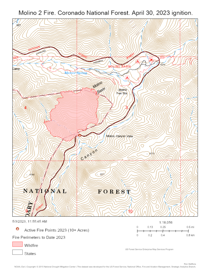
It’s Sunday, April 30, at milepost 4.5 on the Catalina Highway, in a section of the Coronado National Forest that is a recreation gateway for Tucson, Arizona. The day reaches 100 degrees for the first time of the year, and there’s a Red Flag Warning.

Most folks might think that this is not a good day to demonstrate how adept they are at shooting a shotgun at an oddly dressed torso target with what seems to be incendiary shells. Even a worse day to demonstrate this five times, on video.

Screenshot from video, showing the target and the shooter whose identity is being sought by Coronado National Forest investigators.

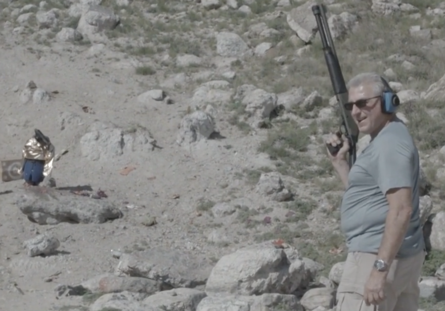
But the correct decision wasn’t what the unnamed man in the video elected to do. His identity is being sought by Coronado National Forest investigators in connection with the Molino 2 Fire.

The forest shared the video in a media release noting that video evidence was obtained showing the suspect and the start of the Molino 2 Fire. Video footage shows an approximately 50- to 60-year-old, white male wearing a light grey shirt with tan cargo pants approaching the scene where others with a camera were shooting at a homemade target. Upon his arrival, they stepped back and allowed him to take five shots using his own shotgun. It appears in the video the suspect had it loaded with incendiary shells  causing sparks to fly and starting the Molino 2 Fire.

The release notes that using incendiary ammo and starting a wildfire are violations of 36 CFR 261.5 (b,c) punishable by up to 6 months in jail and/or $5,000. These violations are considered Class B Misdemeanors. In addition to the fine, some of the cost may be recovered through restitution.

The fire was reported to be contained at 110 acres, with no cost estimate available. The Catalina Highway was closed for a portion of the first day of the fire, causing significant delays of a Sunday afternoon mountain traffic.

The video shows a man who shoots with enough care to wear ear protection. First, he looks back – to recognize the person with the camera, and then he turns and begins what appears to be a very conscious act – as the use of any weapons should be, by ethics and law.

VIDEO:  https://youtu.be/cV1hlbXff7Q

In the video embers are visible flying from where the target is hit, bouncing off surrounding rocks. The shooter fires a total of five shells until he empties his shotgun.

A still-frame from the video. Source: Coronado National Forest.

At 34 seconds into the video, the camera pans left and focuses on nearly a dozen little spot fires. Within 15 seconds the flamelengths are 2-3 feet high and the spots burn together into three distinct fires at the base of a canyon chute.

The techniques and success of fire prevention are often framed by the Three E’s – Education, Engineering and Enforcement. All three E’s are in place in this section of the Catalina Highway (which I know well, as it leads to some of my favorite hiking and running routes, and I’ve managed fires there in the past). With education having already been ignored by the shooter, and the engineering being crossed (since most of this area is closed and flagged off along the highway), then the third E of enforcement is the last tool left, with a 49-second video to support the case, as well as 110 acres of burnt desert and grassland as evidence.

Anyone with information regarding this incident and the suspected shooter is asked to call 520-388-8343 or email the Coronado National Forest at Mailroom_R3_Coronado@usda.gov

Molino 2 Fire, Coronado National Forest. April 30, 2023..

Virginia deputy chief dies of heart attack after wildfire response

Chief Lauck
Chief Chester Lauck

A Virginia firefighter, Deputy Chief Chester T. Lauck with Frederick County Fire and Rescue, suffered a heart attack hours after responding to a wildfire and died the following morning.

The notice from the Frederick County Government Facebook page on Sunday announced “On behalf of Fire and Rescue Chief Steven A. Majchrzak, it is with profound sadness that we announce the Line-Of-Duty Death of Deputy Chief Chester T. Lauck, who passed away this morning at 8:09 a.m. at Winchester Medical Center surrounded by family and friends.”

Lauck LODD

In his most recent position, Lauck was responsible for the Emergency Management Division. Prior to that he had worked for the Winchester (Virginia) Fire and Rescue Department and had retired He retired from the Metropolitan Washington Airports Authority (MWAA) Fire and Rescue Department as a Battalion Chief of the Special Operations Division. He’d also worked as an Aircraft Rescue and Fire Fighter (ARFF) for the Air National Guard and began service in 1984 as a patrolman for the Virginia Department of Forestry, where he worked on wildland incidents and events.

Earth Day is a quiet fire day – except for coastal North Carolina

On April 22, 2023, Earth Day 2023,  the largest fire of national note is burning in North Carolina.

For April 21, the most recent update of the national portal for the Geographic Area Coordination Centers – because it’s not quite busy enough for weekend staffing – there are three GACCs at Preparedness Level 2 – Eastern, Southern, and Southwest – while the rest of the country is at PL 1.  And a scan of national-level fire hazards doesn’t show any Red Flag Warnings or Watches for the day.

For the prior week, national initial attack activity in the National Situation Report was considered light at 1,075 fires, with 50 large fires reported and 50 contained. Fire names ranged from a label only an agency can love (AR-BUP-000924 in the Buffalo National River)  to a menagerie of animals – Swine, Third Goat, Antelope Flats, Wolf Creek, Otter Creek, Kingfisher Hollow – to the uniquely local – Natural Bridge (named for the actual Natural Bridge in Kentucky), Muzzle Loader Club (perhaps the local shooting range in Oklahoma?), Jimmys Water Hole in New Jersey and Shinhollow in New York, and Tinaja in southern Arizona (translated from the Spanish as “large earthenware jar”).

The Fire Weather Outlook for Earth Day was minimal except for southwest Arizona. The Day 2 Fire Weather Outlook for today noted that “Elevated conditions are likely near the international border in the Lower Colorado River Basin, as 15 mph sustained southwesterly surface winds overlap with 15 percent humidity for a few hours around afternoon peak heating. Elevated highlights were added since fuels should be marginally receptive to fire spread.” Looking ahead, the only fire hazard of note in the fire weather outlook is for the New Mexico-Texas-Mexico area on Tuesday-Wednesday, April 25-26.

All this being duly noted, one can be certain that residents near the Great Lakes Fire will agree that this fire (also called the Great Lake Fire) likely holds claim to being Earth Day’s fire of note in the U.S. Named for a singular Great Lake, with other lakes around it, in the Croatan National Forest), the fire quadrupled in size in 24 hours, from 7000 to an estimated 30,000+ acres, with a national Southern Area fire management team being assigned.

As noted yesterday in our partner site, FireAviation.com, the VIIRS satellite data offered space-based mapping of  yesterday’s growth that was confirmed in the map available today from the Risk Management Assistance Dashboard … compared to yesterday’s rapid spread, the majority of recent heat signatures are to the north, where the fire is burning into and between past fuel treatments. The fire has definitely outgrown the 21,000 acre footprint of 2012’s Dad Fire.

Great Lake Fire Croatan NF NC 2023-04-22

Additional mapping is being shared by Joseph Elfelt …

And current info arrives from a variety of Twitter posts with the handle of #GreatLakeFire (no plural) …

A recent tweet equated the fire’s size to the acreage of DisneyWorld, which, in case you were curious, was forecast to have average crowds for Earth Day according to the Magic Guides Crowd Calendar.

There is no current estimate for how many firefighters are working the Great Lake(s) Fire, though it’s certainly increasing. Yesterday’s census for the Southern Area had some 1200 resources assigned in the overall GACC area.

Northeast News: RxFire, highway closure, and drone warnings

April in New Jersey was dry and windy enough for numerous Red Flag Warnings this past week, but the state Forest Fire Service still pulled off a prescribed burn and contained a wildfire.

NJ Forest Fire Service firefighters Log Swamp Fire 20130416
New Jersey Forest Fire Service firefighters patrol the line on the Log Swamp Fire. Photo: NJ Forest Fire Service.

Another New Jersey fire, the Kanouse Fire, burned 1000 acres in northern New Jersey, leading to evacuations — of five homes and 100+ animals from the Echo Lake Stables. Embers were reported to have started fires a half mile across Echo Lake, with the fire staffed by multiple agencies.

Though fire danger has been high to very high statewide in recent days, fire restrictions have been lifted in two of the three statewide zones as today’s calmer winds reduced fire risk.

Today’s date also marks 60 years since New Jersey’s “Black Saturday” on April 20, 1963, when 30-50 mph winds, humidity in the low 20s and temperatures in the low 80s fanned the rapid spread of 31 major fires that burned 190,000 acres, destroyed or damaged 400 structures, and evacuated 2500 residents.

Meanwhile, in Pennsylvania, after a week with the entire state in high fire danger, the southern and central zones are now in high fire danger and the rest of the state is classed as moderate.

This past weekend, according to Lehigh Valley Live, the 4000-acre Crystal Lake Fire east of Mountain Top led to the closure of 20 miles of the Pennsylvania Turnpike between the Poconos and Wyoming Valley interchanges.

Also during the weekend, a drone-airspace intrusion on the Peter’s Mountain Fire in Dauphin County was reported by WGAL-TV.  The report reminded people that interfering with firefighting operations on public lands, per the Federal Aviation Administration, can carry a 12-month prison term, and drone pilots who interfere with wildfire suppression could also receive a fine of more than $37,000.

National Firefighter Registry opens for profession-wide cancer monitoring

The National Firefighter Registry (NFR) officially opens its enrollment portal today after a few months in pre-launch testing and years of preparation by the National Institute for Occupational Safety and Health (NIOSH). Wildland and structural firefighters who register and share their exposure histories at NFR.cdc.gov will help support the NFR’s goal of understanding and reducing cancer in firefighters.

The registry seeks comprehensive participation and notes four objectives that firefighters will support by enrolling:

      • “Help protect your brothers and sisters in the fire service from developing cancer
      • “Help lessen the impact of cancer on firefighters’ families and friends
      • “Pave the way for new health and safety measures to keep the next generation of firefighters safe
      • “Improve understanding of cancer risk among minority, female, and volunteer firefighters, as well as groups like wildland firefighters”

To develop comprehensive and ongoing  analyses of risks and illnesses, the NFR  encourages participation by all firefighters, structural and wildland, and all statuses — volunteer, on-call, seasonal, full-time, retired, disabled, with or without a cancer diagnosis.

While the images on the registry often focus on structural firefighters, the associated links include background health and cancer information for wildland firefighters and a web page focused on outdoor workers and smoke.

National Firefighter Registry

Bill Gabbert wrote many articles in Wildfire Today covering the genesis and progress toward the National Firefighter Registry (also referred to as the “cancer registry”). One article shared Kathleen Navarro’s “A Brief Look” at cancer and health risks for wildland firefighters, which notes an estimated 8-43% increased chance of lung cancer and a 16-30% increased risk of heart disease mortality among wildland firefighters. Gabbert died of cancer in January.

For agencies and organizations seeking to support enrollment, a communications portal offers a range of print and social media messages.

One suggestion when registering: gather up your experience records first. I completed the first three registration stages (the “profile” stage) in around 10 minutes and then took a break to collect some notes on seasons of service and types and amount of exposure. A registrant can step aside from the profile stage of the portal and continue later, but once you enter details of your fire experience in the “experience” stage of registration, you aren’t able to edit it.

Recording an accurate representation of work and fire experience is a core component of the registry, which seeks to create a database of fire experience, firefighter’s risk exposure and long-term health effects. This has proven a challenge for researchers examining the higher prevalence of cancer occurrence among firefighters.

This can be particularly challenging with wildland firefighters serving on seasonal assignments (and with seasonal exposure to many varieties and quantities of smoke and other potential fireline-related carcinogens). The registry includes questions that may assist in determining wildland smoke exposure, including a firefighter’s role in fire — such as hand crew, engine crew, aviation, etc.; firefighter or fire manager; and the duration and type of fires (wildfire vs. prescribed) that a firefighter responded to on average, by the specific positions held. The experience questionnaire includes most varieties of fire experience, including wildland-urban interface as compared to wildfires. The experience and personal demographic sections may take from 20-30 minutes to complete, longer if you’d had a variety of positions and fire experience in your career.

National Firefighter Registry - Stage 3 profile completed.
National Firefighter Registry – the Profile stages completed. Take a break and gather your exposure history before tackling the Experience Questionnaire.

The document below shares a step-by-step process. Note that the consent is in-depth, in part to ensure participants that their shared information will be kept confidential. Survey questions include general health and demographic questions, including a history of tobacco or alcohol use and workplace but non-fire exposure to potential carcinogens.

Once a firefighter is registered, an anonymized tracking system in state cancer registries will link a cancer diagnosis (if one occurs) to the last four digits of a social security number, which will then correlate the diagnosis with the NFR data that includes the firefighter’s experience and exposure. In some cases, NIOSH may connect with a registered firefighter to seek voluntary participation in additional research.

[pdf-embedder url=”https://wildfiretoday.com/wp-content/uploads/2023/04/How-to-signup-for-Firefighter-Registry.pdf” title=”How to signup for Firefighter Registry”]

Earlier, warmer spring ramps up Eastern Area fire season

The Jimmy’s Waterhole Fire in New Jersey was declared 100% contained on Thursday by the New Jersey Department of Forestry, having burned some 3900 acres, nearly half the state’s annual average in two days.

This and other regional fires prompts a visit to the Eastern Area Fire Environment Outlook to explore the conditions that led to the late April fire bust. On Friday’s Morning Briefing, the Eastern Area Coordination Center had nearly 40 percent of reporting units in Very High to Extreme Fire Danger, with the largest fires in New Jersey, Missouri, Pennsylvania, Michigan and Rhode Island. In the past week, the region recorded 349 fires for 12,600 acres.

While spring is often active in the east — as forest fuels dry out between winter snow and rains and prior to green up —  the last week was drier throughout the Northeast and Midwest, as well as in the Great Plains and Southwest. Look south and you can spot the focused and incredible “purple” deluge in Fort Lauderdale, Florida, and to the north there’s an unusual heart-shaped moisture pattern in Michigan.

7-Day Percent of Normal Precipitation through April 14, 2023.

Spring in much of the East and Midwest was also warmer than normal

… resulting in a 10-20 day earlier start to spring in the South and East, per the National Phenology Network. At least one location in New Jersey was tracked at 27 days early.

Fire activity in the region has been moving northeast toward Maine with the bubble of heat, including a fire point seemingly in the Atlantic — though a closer look at the Fire Weather Dashboard (with fire points activated) places the the fire on Martha’s Vineyard.

Soon, though, the spring fire season will be taking a hiatus, with greenup, increasing humidity, and even fog on the way. By Monday, moisture is expected in the East, with most predictive service areas transitioning to “Little or no risk.”