Decker Fire grows to over 8,000 acres

Rapid spread of the fire Sunday forced fire crews to escape to a safety zone

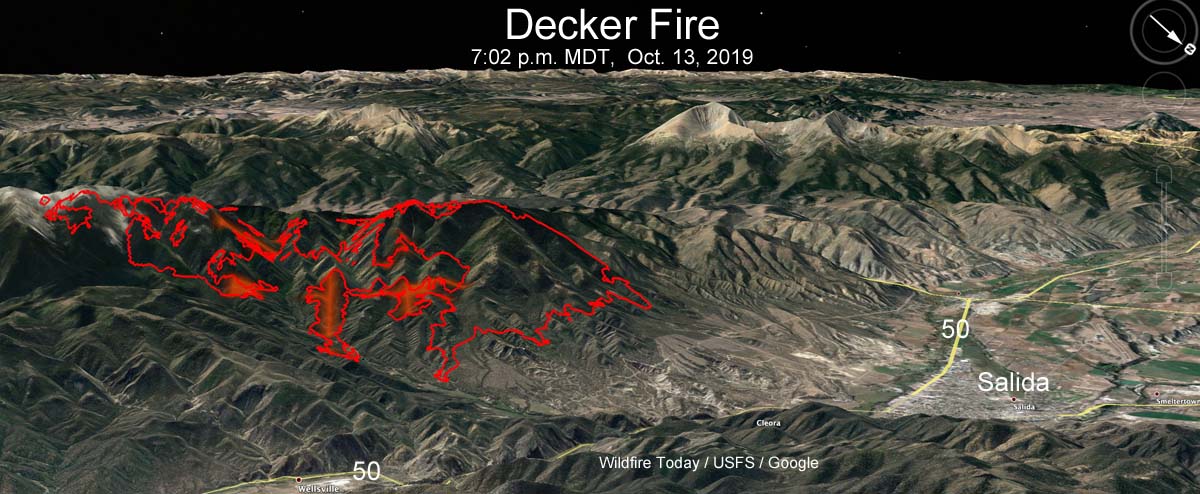
map of the Decker Fire
3-D map of the Decker Fire at 7:02 p.m. MDT Oct. 13, 2019. The red shaded areas represent intense heat. Looking southwest. Click to enlarge.

UPDATED at 10:25 p.m. MDT Oct. 14, 2019

The Decker Fire has ordered nine more 20-person hand crews. They will be Type 2 IA (Initial Attack) crews coming all the way from Oregon.

The weather near Salida is not expected to be extreme through Thursday; the winds will be from the west or southwest at less than 11 to 14 mph but the humidity will be very low — single digits during the day and in the 30s at night. But beginning Friday and through the weekend the wind will increase to the mid-teens with gusts in the 30s. There is a chance of rain or snow on Sunday.

Those crews might be handy to have around on Friday and Saturday, and also to get more line construction and mopup done before the winds arrive.


4:02 p.m. MDT Oct. 14, 2019

The Decker Fire three miles south of Salida, Colorado continues to grow and Sunday put firefighters in a precarious situation. After the fire crossed fire lines on both the east and west sides following three days of Red Flag Warnings firefighters on the northeast side working to stop the spread had to use escape routes to take refuge in safety zones. After taking accountability to ensure all were safe, they reengaged after the fire activity decreased.

(To see all of the articles on Wildfire Today about the Decker Fire, including the most recent, click here.)

More fire crews and aircraft have been requested and new evacuation orders for residents issued.

The 8,118-acre lightning-caused fire has been burning for about five weeks and is being “managed” or herded around, rather than fully suppressed.

For evacuation  information contact the Chaffee County Sheriff’s Office, 719-539-2596, or Fremont County Emergency Management, 719-276-7416, 719-276-7418, or visit the Chaffee County Sheriff or Fremont County Sheriff Facebook pages and websites.

Resources assigned to the fire include: 18 hand crews, 27 fire engines, 4 dozers, 8 water tenders, and 7 helicopters for a total of 707 personnel.
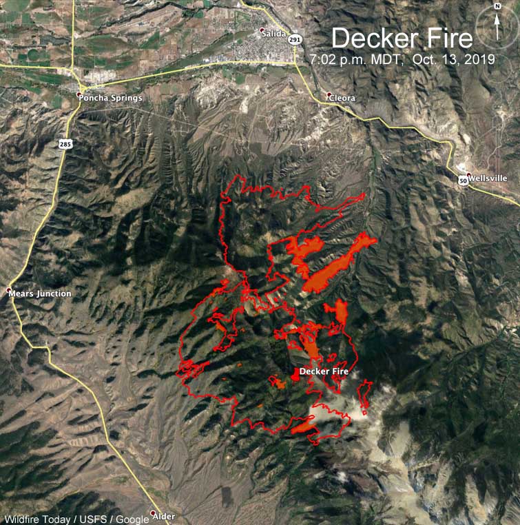
Map Decker Fire
Map of the Decker Fire at 7:02 p.m. MDT Oct. 13, 2019. The red shaded areas represent intense heat.

The video below that shows the smoke column blowing rapidly off to the left is time-lapse, not real time.

Accuracy and Critique

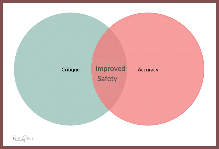
Critique vs accuracy venn diagram

When a wildland fire incident has a controversial outcome it will often be pointed out by those who are knowledgeable on the subject, or by someone who is directly or indirectly affected.

I understand how venting can be cathartic. As long as it is done in private, no problem. If it is done in public there can be cascading repercussions, and therefore more responsibility. At worst, it can be self-serving, cruel, damaging, and counterproductive. But if everything said is completely accurate, and the result can benefit mankind, then the greater good might be served in many situations. At Wildfire Today, I know that sunlight can be the best disinfectant. Helping shine a little light on lessons learned by firefighters through information about reports being released or critique from various sources, might reduce the chances of someone else learning a lesson the hard way — with unpleasant consequences.

Years ago in a comment section on Wildfire Today someone made statements about another person. It was slanderous, not true, and damaged the reputation of a very honorable and skilled professional. Since then I have strived harder to have factual information on the web site. There are times when that objective is not met, but it does not stop me from trying.

Even the best intentioned formal investigations of incidents may occasionally miss the mark of being accurate. Other times the report an investigation team releases might purposefully deceive, or lie by omission. I certainly do not have all the answers, not by a long shot. In cases like these, and others, attention is needed by the hive mind of the wildland fire community.

Critique not meshing with accuracy can keep me up at night.

Powerline investigated as possible source of Saddle Ridge Fire

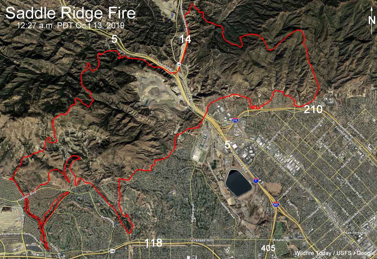
Above: 3-D map of the Saddle Ridge Fire at 12:27 a.m. PDT October 13, 2019.

Fire investigators are looking at a power line as a possible ignition point for the Saddle Ridge Fire that burned 7,965 acres and 21 structures on the north side of Los Angeles. (see map above) At least two residents of Sylmar said they first saw the fire at the base of a transmission tower. Los Angeles Fire Chief Ralph Terrazas said Friday night that he was aware of those reports, and, “We believe that witness, and someone else who said something similar.” The Southern California Edison power line had not been shut off during the Santa Ana wind event.

All of the evacuation orders have been lifted that earlier affected about 100,000 residents.

(To see all articles on Wildfire Today about the Saddle Ridge Fire, click here.)

The strong north to northeast Santa Ana wind event that caused the fire to spread seven miles, from Sylmar to Granda Hills and almost to Chatsworth, has come to a close. The area is now experiencing typical on shore flows, bringing higher humidity and lower temperatures.

One person died during the fire. Authorities said Aiman Elsabbagh, 54, suffered a heart attack while trying to protect his home with a garden hose and passed away later in a hospital.

Map Saddle Ridge Fire
Map of the Saddle Ridge Fire at 12:27 a.m. PDT October 13, 2019.

Santa Fe National Forest fuels & restoration videos, parts 9 and 10

fuel management fire forest wildlife
Screenshot from Part 9 of the Santa Fe NF series of videos on fuel management.

Here are parts nine and ten in the series of 12 videos produced by the Santa Fe National Forest on the topic of fuel management and forest restoration.

Fuel Management is defined as:

An act or practice of controlling flammability and reducing resistance to control of wildland fuels [vegetation] through mechanical, chemical, biological, or manual means, or by fire, in support of land management objectives.

Forest Restoration:

Actions to re-instate ecological processes, which accelerate recovery of forest structure, ecological functioning and biodiversity levels towards those typical of climax forest, i.e. the end-stage of natural forest succession.


Part 9, Wildfire and Wildlife


Part 10, Fire Legacy of the Jemez People

Other videos in the series, published weekly, can be seen here. The final video will appear on October 20, 2019.

Top Tweets from the Saddle Ridge Fire

Helicopter night water drop Saddle ridge Fire
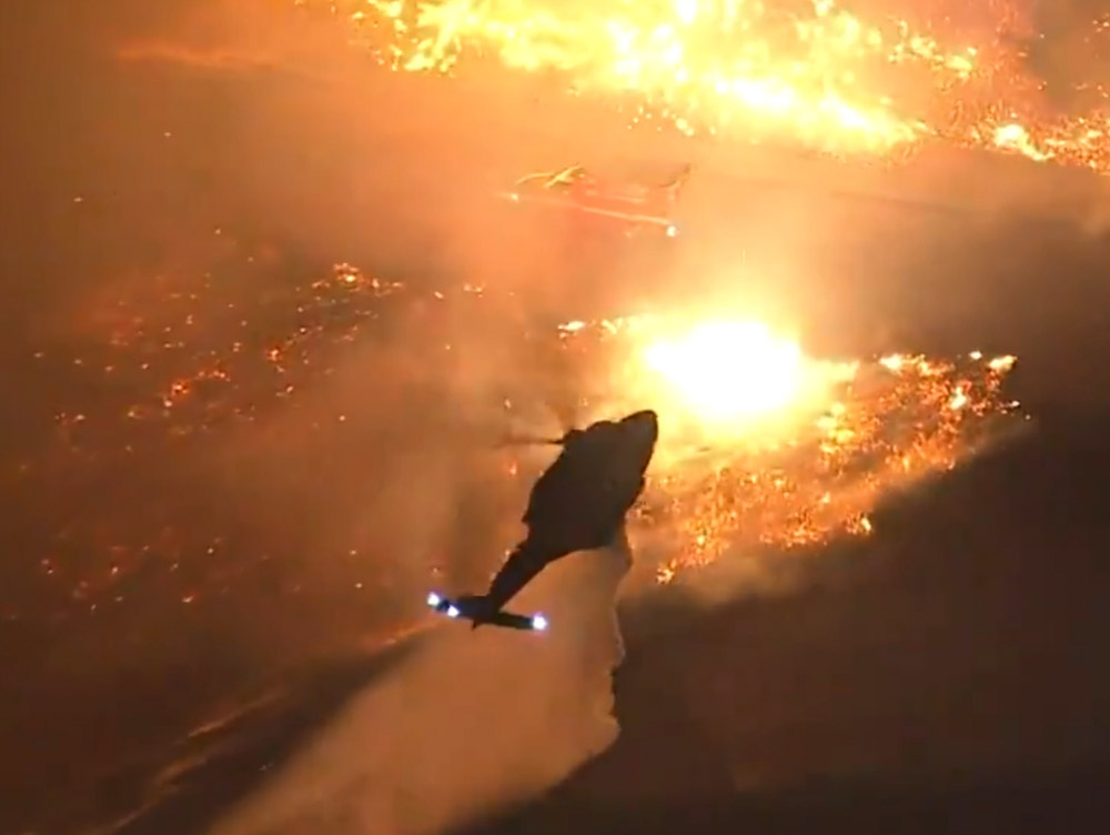
A helicopter drops water near a fire engine during very windy conditions on the Saddle Ridge Fire in Los Angeles. Screenshot from KTLA video.

Below is a collection of some of the more interesting tweets that recorded activity during the Saddle Ridge Fire on the north side of Los Angeles October 10 and 11, 2019. The fire has burned 7,552 acres and damaged or destroyed 31 structures (13 are 100% loss, 3 are 50% loss, 4 are 25% loss and 11 are 10% loss). Most, but not all, mandatory evacuations have been lifted. More information is at the Los Angeles Fire Department website.

(Click here to see all articles on Wildfire Today about the Saddle Ridge Fire, including the most recent)

Continue reading “Top Tweets from the Saddle Ridge Fire”

Caples Fire spreads to the south

The escaped prescribed fire is 15 miles southwest of Lake Tahoe

Caples Fire 3-D map
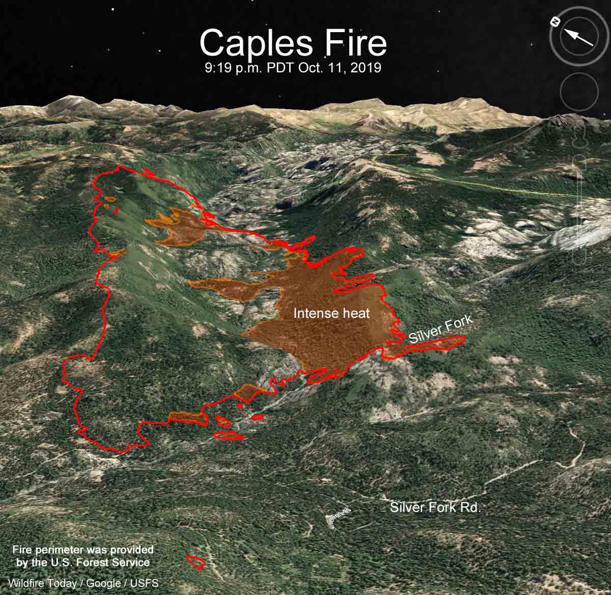
3-D map showing the perimeter of the Caples Fire at 9:19 p.m. PDT Oct. 11, 2019 that was provided by the U.S. Forest Service.

The south side of the Caples Fire was active Friday and spread across the Silver Fork of the American River. According to information released by the U.S. Forest Service the fire was mapped at 2,666 acres Friday night. The north perimeter is fairly quiet, but the mapping flight found intense heat along sections of the south perimeter.

The fire is on the Eldorado National Forest 3 miles west of Kirkwood, California and 15 miles southwest of the south shore of Lake Tahoe. A Type 3 Incident Management Team has assumed command. Resources assigned include 6 Type 1 Hotshot crews, 8 Type 2IA hand crews, 3 helicopters, 20 engines, 3 dozers, and 3 water tenders for a total of 752 personnel.

The Caples Fire has not been listed on the National Interagency Coordination Center’s Incident Management Situation Report for the last two days. The estimated costs of suppressing the fire through October 11 is $250,000, according to the Incident Status Summary report.

The fire began as a project to burn debris piles and was classified as a prescribed fire. Personnel from the El Dorado National Forest, as described on the Forest’s Twitter account, conducted ignition operations on at least the following days: October 1, 5, 7, 8, and 9. (More details are in October 11 article) Strong winds that had been predicted for several days arrived on October 9 along with a Red Flag Warning. As the fire continued to spread beyond the intended objective for burning the piles, on Friday October 11 the Forest Service changed the status of the prescribed fire to a wildland fire.

Smoke from the fire can occasionally be seen on live cameras depending on the direction they are pointed. Check out the Leek Springs, Sierra at Tahoe, and Big Hill cameras.

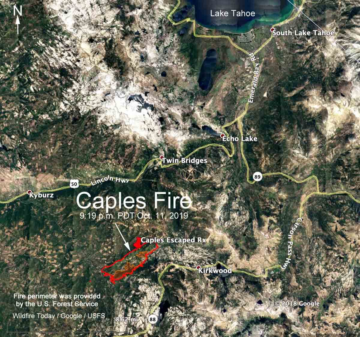
Caples fire map
Map showing the perimeter of the Caples Fire at 9:19 p.m. PDT Oct. 11, 2019 that was provided by the U.S. Forest Service.