Department of the Interior collaborated on 2,500 fuel treatment projects last year

s2t airtanker holy fire
An S-2T air tanker comes out of the smoke to drop retardant near the communication towers on Santiago Peak in Southern California August 8, 2018 as the Holy Fire approaches. HPWREN image.

Opinion: by David L. Bernhardt, Secretary of the U.S. Department of the Interior

Last year’s wildfire season was one of the worst on record as more than 58,000 wildfires burned more than 8.8 million acres across the United States. Nearly 26,000 structures were destroyed — more than double the previous annual record — and 19 valiant members of America’s firefighting community lost their lives.

Across the country, more than 98 million people live within or adjacent to lands susceptible to wildfires. As more and more people move into or near wildfire-prone areas, it’s paramount that federal, state, and local partners collaborate on ways to effectively protect local communities.

At the Department of the Interior, we have made wildfire preparedness a top priority. Our national wildfire reduction strategy is guided by President Donald Trump’s executive order and furthered by my order. These orders guide the active management of our lands and forests and encourage managers to think about reducing fire risk in their land management actions. Implementation of both orders is a priority for reducing the risks of deadly and destructive wildfires.

This coordinated framework will help ensure the protection of people, communities, and natural resources. We are also harnessing state of the art technology and robust intergovernmental partnerships to keep our communities and wildlands safe from the kinds of devastation we have seen in the past, but this is no easy task.

Our Wildland Fire Management program uses innovative, informed approaches to minimize wildfires. While topography, terrain, and weather are often external factors that spark a wildfire, we can control the fuel that allows fires to spread, as excess vegetation leads to increased wildfire frequency, size and intensity.

Vegetation treatment methods include thinning and timber harvest; controlled burns — quite literally, fighting fire with fire — chemical treatments; targeted grazing; mechanical removal; mowing or cutting; logging; and fuel breaks, or gaps in vegetation that limit the spreading of fires. When a wildfire burns into a fuel break, the flame lengths decrease, and its progress slows, making it safer and easier for firefighters to control.

We’ve used all of these methods to try to mitigate the damage caused by wildfires, as we collaborated with federal, tribal, state and local partners on nearly 2,500 treatment projects over the past year. Leveraging these partnerships, we removed excess burnable vegetation on more than 1.2 million acres of Interior and tribally administered lands, which is 17 percent more treated acreage than in 2016, to reduce the intensity and frequency of fires in high-risk areas. Helping lead these efforts, we conducted 1,552 drone missions on 200 individual wildfires, more than double those of the previous year.

This wildfire season, we have ramped up our efforts and mobilized an array of resources by land and air.

By the season’s end, the department will have deployed approximately 4,500 firefighting personnel — including an all-female fire crew that battled blazes in Alaska — 500 tribal firefighters, 151 smokejumpers, 18 interagency hotshot crews and four tribal hotshot crews. Wildland firefighters have at their disposal more than 600 pieces of specialized equipment, including engines, water tenders and dozers. Aviation assets also continue to play a critical role in efforts to manage wildfires, as the department employs 23 single-engine air tankers, six water scoopers, helicopters, and drones.

We are using everything at our disposal to protect Western communities from wildfires; and, with the help from the John D. Dingell, Jr. Conservation, Management, and Recreation Act’s provisions on wildfire technology modernization, we will continue to use advanced and emerging technologies to stay on the cutting edge of firefighting and fire prevention. The department is also actively harnessing state-of-the-art technology to improve real-time communication and tracking for incidents to increase firefighter safety.

In Colorado, more than 27,000 acres of land will be treated by the end of this fiscal year. One specific project completed already by the Bureau of Land Management is a 286-acre prescribed fire near Bayfield called the Rabbit Mountain Project Prescribed Fire. It was completed to restore and maintain a healthy ecosystem and reduce the risk of wildfire to private lands in the area. The prescribed fire will reinvigorate grasses, forbs, and shrubs and improve deer and elk habitat. Numerous other areas around the state are being treated, in addition to the active wildfire management that is ongoing to contain and extinguish current wildfires.

Under President Trump’s leadership, the Department of the Interior is pursuing innovative and effective wildfire management efforts, and we have made significant progress so far to deliver on the president’s goals for wildfire prevention and treatment. More work can and must be done, and we will continue to find new and improved ways to keep our people, communities, lands and resources safe and secure — now and in the years ahead.

Orange County introduces pilot program for real time wildfire mapping

It is another step toward the Holy Grail of Wildland Firefighter Safety

FIRIS fire wildfire mapping real time
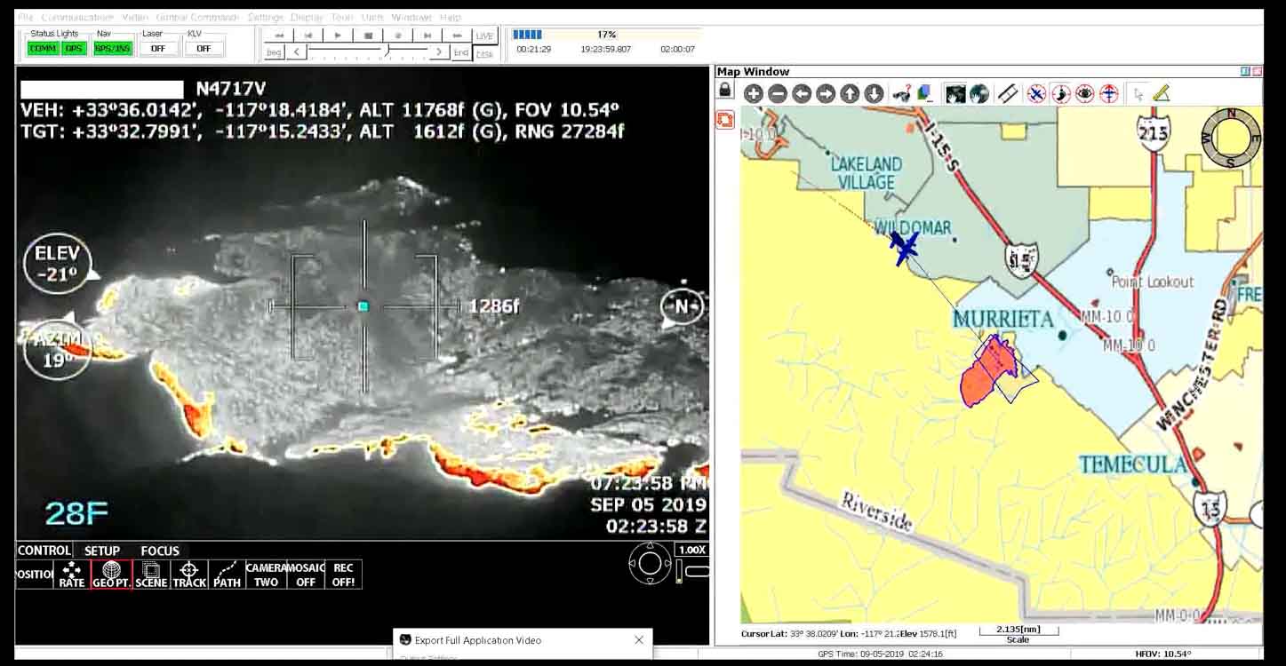
An example of the technician’s screen when using the FIRIS system. Screenshot from the video below.

This month the Orange County Fire Authority began a 150-day pilot program that could lead to real time fire mapping being available to firefighters on the ground. Not knowing exactly where a fire is has been a factor in more than two dozen firefighter fatalities in recent decades. Smoke, terrain, and darkness can obstruct the view of fire crews and supervisors which can severely compromise their situational awareness.

The 150-day Fire Integrated Real-Time Intelligence System (FIRIS) pilot program got off the ground September 1 thanks to funding secured in the 2019-2020 California state budget by Assemblywoman Cottie Petrie-Norris (D-Laguna Beach).

“The State of California must shift strategies to address the constant crisis of wildfires – this is no longer a seasonal threat,” stated Assemblywoman Petrie-Norris. “I am proud to have partnered with the Orange County Fire Authority in securing $4.5 million in state funds for technology that will protect lives and property by giving first responders better, stronger tools to use against the threat of wildfires.”

The system utilizes a fixed-wing aircraft equipped with infrared and radar sensors that can see through smoke. The plane provides real-time fire perimeter mapping and live high definition video to support supercomputer-based wildfire predictive spread modeling.

FIRIS fire wildfire mapping real time
Screenshot of aircraft featured in the FIRIS B-Roll video.

A supercomputer at the University of California San Diego will run fire spread projections based on fire perimeter data collected by the aircraft. The output will estimate where the fire will be in the next six hours. The fire spread model will adjust for successful fire suppression actions by firefighters on the ground and in the air. This intel allows for more timely and accurate decision making for resource allocation and evacuations.

“The ability to place resources exactly where they need to be to successfully battle a wildfire can mean the difference between lives and property saved or lost”, said Orange County Fire Authority Fire Chief Brian Fennessy. “Technology is becoming increasingly important as we work to suppress wildfires quickly. We’re hopeful this pilot program may someday become a routine asset statewide.”

For decision-makers on the ground, a common operating picture increases situational awareness. Firefighters on the front line, incident commanders, law enforcement, and regional and state emergency operation centers all could have the ability to see the same fire intel on a smartphone, tablet or computer in real-time. Fire perimeter maps and live video feeds are provided through an electronic network to assist decision-makers.

This is another step toward the Holy Grail of Wildland Firefighter Safety which would ultimately provide to fire supervisors the real time location of a fire and the location of firefighting personnel and equipment.

The video below is “B-Roll”, that is, unedited footage. The first 6.5 minutes are simply images of aircraft, but after that you will be able to look over the shoulder of the imagery technician as he observes infrared imagery of a fire, manually interprets the heat signatures, then traces the fire perimeter on the screen. That perimeter could then be electronically sent to the super computer in San Diego County which would run a fire spread model to predict what the fire will do in the next six hours.

Autopsy shows CAL FIRE firefighter died of heat exposure

His body temperature was 107.4 degrees

Yaroslav Katkov
Yaroslav Katkov

A CAL FIRE firefighter who died July 28, 2019 in San Diego County died of a heat exposure, reports NBC San Diego.

Yaroslav Katkov, 28, collapsed during his second attempt at a 1.45-mile training hike near the De Luz Fire Station while wearing full gear and carrying 20 to 30 pounds of weights, according to an autopsy.

He was flown in an air ambulance to Temecula Hospital but suffered a two-minute seizure while en route. When he was admitted, his body temperature was 107.4 degrees. Fifteen hours later he was pronounced dead.

CAL FIRE’s preliminary report on the incident, the “Green Sheet”, said the three-person crew began a physical training hike at 8:40 a.m. with the expectation that they would finish within the 30-minute time limit. Mr. Katkov struggled, stopping multiple times, completing the hike in 40 minutes. After a 20-minute break to rehydrate, the Captain had the crew repeat the hike at 9:40 a.m.

NBC San Diego described what occurred on the second hike:

Katkov took more than 20 breaks along the trail which were documented by the captain, the report said. About halfway through the trail, the second firefighter noticed Katkov stumbling and losing his balance. He was told to hike directly behind Katkov and hold onto him so that he didn’t fall off the trail.

As they approached a ridge, the firefighter had to push Katkov’s back to help him get over. Once Katkov did, he fell forward and sat down. Katkov was then told to remove some of his gear so that he could cool down but was unable to, the report said.

More gear was taken off, and water was poured over Katkov’s head. At around 10:38 a.m. when the fire captain noticed Katkov’s mental status declining, he called for an air ambulance rescue.

Cal Fire’s helicopter arrived over Katkov and the crew at approximately 11:19 a.m. and Katkov was hoisted from below, according to the report. About 15 minutes later, the Cal Fire [helicopter] dropped Katkov off at a site where a Mercy air ambulance was waiting to transport Katkov to the hospital.

The second helicopter took off with Katkov inside at around 12:04 p.m., about an hour-and-a-half after the fire captain called for emergency assistance. On the way to the hospital Katkov was unresponsive but breathing, according to the report.

KNTV reported that Mr. Katkov was flown to Temecula Valley Hospital. Google Maps shows it would take an estimated 31 minutes to drive from De Luz Station to Temecula Valley Hospital, part of the time on curvy county roads. Based on that, we can assume it would take no more than 10 minutes for the Mercy air ambulance to arrive at the hospital — at about 12:14 p.m. This was approximately one hour and 36 minutes after the request for extraction by helicopter. Presumably the incident occurred in a remote area inaccessible by ground ambulance. It is likely that the medical crew on the Mercy helicopter began treatment of the patient as soon as he arrived at their location during the 30 minutes before the helicopter took off.

Estimated time line:

10:38 a.m. — Air ambulance rescue requested
11:19 a.m. — CAL FIRE/San Diego Sheriff Dept. helicopter arrives at scene
11:34 a.m. — (Approximate time) The CAL Fire helicopter delivered Mr. Katov to Mercy Air ambulance
12:04 p.m. — Mercy air ambulance departs for Temecula Valley Hospital
12:14 p.m. — (Approximate time) Mercy air ambulance arrives at hospital.

(UPDATE September 28, 2019: here is a link to the CAL FIRE “Green Sheet”.)

Tour of a Hotshot Crew’s fire camp in Alaska

Chena Hotshots fire camp Alaska wildfire
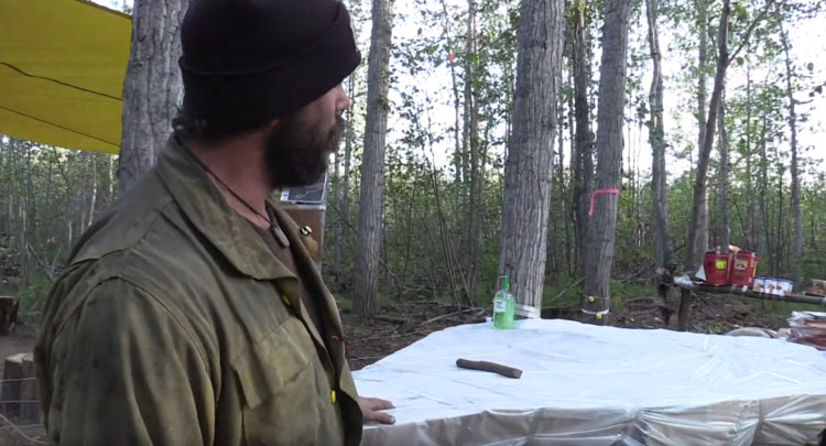
Max Ryan of the Chena Hotshots gives a tour of the crew’s fire camp. Screenshot from the video below.

Since firefighters in Alaska are often based far from roads they may establish camps where crews can be self-sufficient for days or weeks at a time, resupplied by helicopters or paracargo. In this video produced August 1, 2019 by the Bureau of Land Management Alaska Fire Service, Chena Interagency Hotshot Max Ryan gives a tour of the crew’s fire camp on the Hadweenzic River Fire at the Cornucopia Complex about 20 miles northeast of Beaver. He explains how they store their food to protect it from bears and use permafrost to chill their perishable items.

Red Flag Warning in Northern California into Wednesday

Winds gusting at 30-40 mph with humidity in the teens

Red Flag Warning wildfire weather
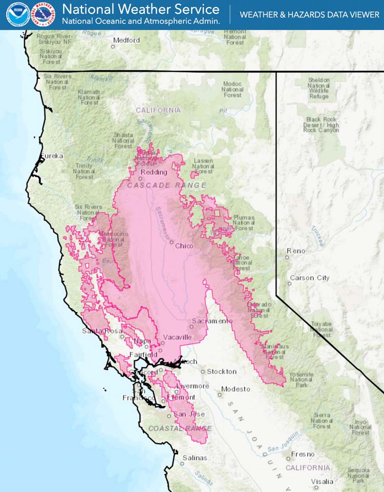
Red Flag Warning in effect until 9 a.m. PDT Wednesday, September 25.

A Red Flag Warning is in effect for portions of interior Northern California until Wednesday morning.

Building high pressure will result in gusty north to east wind
developing Monday and persisting into Wednesday. Combined with
warming temperatures and lowering humidity, this will result in
critical fire weather conditions across portions of Interior
Northern California.

— North wind 10 to 25 mph with local gusts 30 to 40 mph.

— Daytime humidity will be in the 10 to 20 percent range
with poor overnight recoveries of 30 to 40 percent.

— The highest threat will be in the western portions of the Sacramento Valley and adjacent foothills, where the highest wind gusts and lowest
humidity are expected.

(Red Flag Warnings can be modified throughout the day as NWS offices around the country update and revise their weather forecasts.)

Investigators determine wildfire near Helena was started by exploding target

A suspect has been cited and may have to pay suppression costs

North Hills Fire Helena exploding target
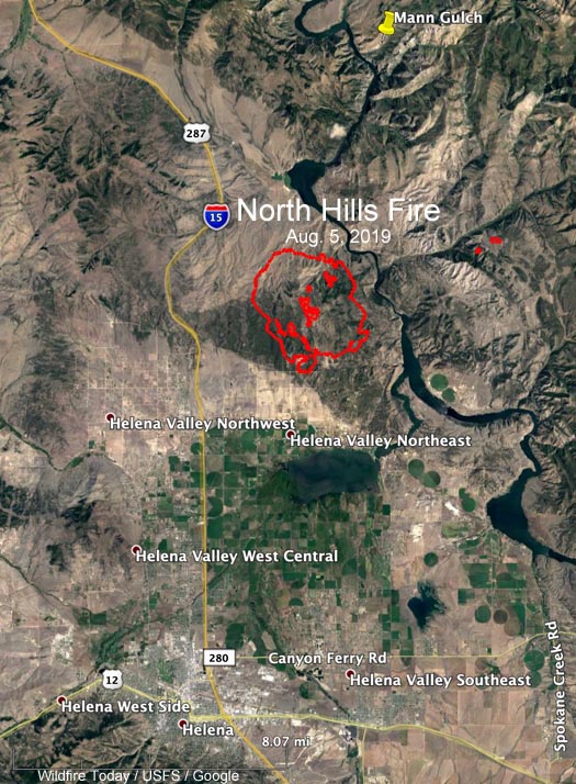
Investigators determined that the North Hills Fire was started by an exploding target on July 26, 2019.

Investigators have determined that the North Hills Fire that burned 5,005 acres 10 miles northeast of Helena, Montana was started by a Tannerite exploding target July 26, 2019.

Below is an excerpt from an article in the Independent Record:

Two citations were filed Thursday against the person suspected of starting the North Hills fire that burned more than 5,000 acres near Helena earlier this summer.

U.S. Bureau of Land Management law enforcement cited the suspect with one count of causing a fire other than a campfire and one count of burning timber, trees, slash and brush outside of a campfire. Each ticket carries a $500 fine plus a $30 processing fee for a total cost of $1,060.

The citations do not include the costs associated with suppressing the wildfire or rehabilitating the burned area. Any possible civil action will be handled administratively by the agencies involved.
The Montana Department of Natural Resources and Conservation has estimated the suppression costs “somewhere in the neighborhood of $7.2 million,” according to Helena Unit Manager John Huston.

“We probably will go after some suppression costs,” he said, noting that the process would probably take about a year.

Local and federal officials have declined to release the suspect’s name.

The North Hills Fire forced the evacuation of 400 homes northeast of Helena.

Walt Jester, Chief of the Lewis and Clark Volunteer Fire Department, took some excellent photos of the fire:

Exploding targets consist of two ingredients that when mixed by the end user explode when shot by a high-velocity projectile. They have caused many fires since they became more popular in recent years, have been banned in some areas, and caused the death of one person. After the ingredients are combined, the compound is illegal to transport and is classified as an explosive by the Bureau of Alcohol, Tobacco, and Firearms.

Thanks and a tip of the hat go out to Paula. Typos or errors, report them HERE.