Company’s spray-on long term fire protection product does not work as claimed, prosecutors say

The company displayed on its website the logo of the National Fallen Firefighters Foundation, with no evidence that the Foundation endorsed the product

Below are excerpts from a press release issued by the Los Angeles City Attorney, Mike Feuer August 5, 2019.


Los Angeles City Attorney Mike Feuer and Santa Barbara District Attorney Joyce Dudley announced  they filed a joint enforcement action against wildfire home protection company, Sunseeker Enterprises, (DBA Sun FireDefense), and its owner, James Moseley, alleging false and misleading advertising claims about the effectiveness and environmental safety of its wildfire home protection product, SPF 3000 Clear Spray. SPF 3000 is advertised as a coating that can be applied to the exterior of a home to prevent it from catching fire and burning down, particularly in a wildfire.

“If you’re selling a product that you claim protects homes from wildfires, it better work as advertised. Lives depend on it,” said Feuer.

“If consumers falsely believe that their homes are protected from wildfires, when in fact they are not, those consumers could delay evacuation, placing their lives, the lives of their families and loved ones, and the lives of first responders at great risk,” Deputy District Attorney Christopher Dalbey said.
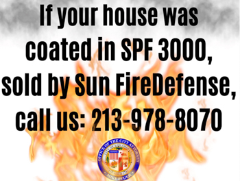
Sun Fire Defense lawsuit
Notice distributed by the Los Angeles City Attorney’s office.

The joint enforcement action filed today arises from Sunseeker Enterprises’ alleged false and misleading television, print, and online advertisements along with advertisements on its website claiming that SPF 3000 Clear Spray “provides protection against heat and embers up to 3000 degrees Fahrenheit,” is “effective for 5+ years after a single application,” was developed “through collaboration with NASA and the U.S. Forest Service,” is “non-toxic to humans or animals,” and uses “[t]he best eco-friendly fire protection materials,” among other allegedly false and misleading claims.

Feuer and Dudley requested that Sunseeker Enterprises substantiate these and other claims and engaged a third-party expert to test a product sample, leading to a lawsuit alleging that SPF 3000 Clear Spray does not perform as advertised, if at all; contains ingredients that under California law are presumptively hazardous to human health and the environment; and wood treated with it did not perform markedly better than the untreated wood.

In addition, Feuer and Dudley allege that Sunseeker misleads consumers through the use of logos — such as the National Fire Protection Association, the National Fallen Firefighters Foundation, and other organizations — on its website and in marketing materials. Sunseeker has not provided documentation establishing endorsements from these organizations.


The above article was modified December 15, 2019 to make it clear that it consists of excerpts from a press release issued by the Los Angeles City Attorney, Mike Feuer August 5, 2019.

Shelter Pass Fire burns thousands of acres west of Great Salt Lake

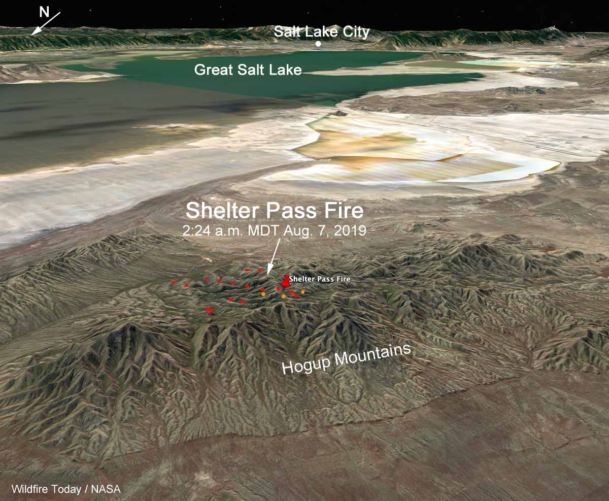
3-D map Shelter Pass Fire Great Salt Lake
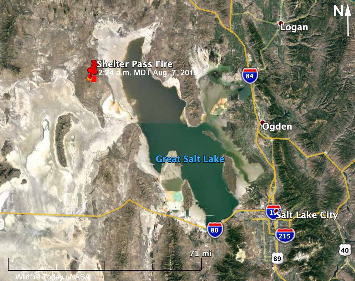
3-D map showing the location of the Shelter Pass Fire in the Hogup Mountains west of Great Salt Lake, at 2:24 a.m. MDT August 7, 2019.

(Originally published at 3 p.m. MDT August 7, 2019)

The Shelter Pass Fire, believed to have started from lightning on Sunday, was very active Wednesday, attracting the attention at various times of two DC-10 Very Large Air Tankers, T-910 and T-911, flying out of Pocatallo, Idaho. The blaze is west of the north end of Great Salt Lake and 77 miles northwest of Salt Lake City. (see map)

The strategy is to fully suppress the fire, but with only 6 engines, 1 helicopter, and no hand crews assigned as of Tuesday night, that will be difficult until forces arrive in much greater numbers.

Wednesday afternoon the Great Basin Coordination Center said the fire had burned 8,500 acres, an increase of 7,900 acres over the size reported Tuesday evening.

As this is written at 3 p.m. MDT Wednesday, Tanker 910, a DC-10, is maneuvering over the Shelter Pass Fire preparing to drop about 9,000 gallons of fire retardant.

map Shelter Pass Fire Great Salt Lake
Map showing the location of the Shelter Pass Fire in the Hogup Mountains west of Great Salt Lake, at 2:24 a.m. MDT August 7, 2019.
Three DC-10 Air Tankers
File photo of three DC-10 Air Tankers at Albuquerque, May 3, 2019: Tankers 910, 911, and 914. Photo by Bill Gabbert.

Wildfire smoke maps for August 7, 2019

Which do you prefer?

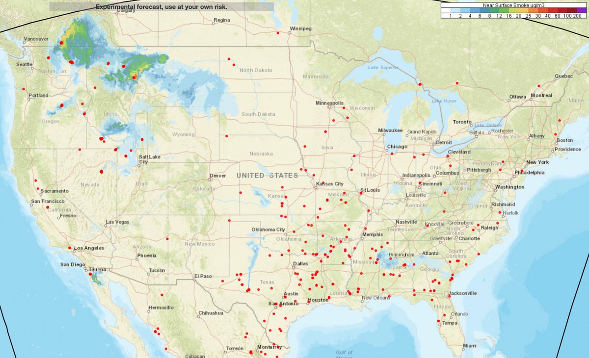
These maps depict the prediction for wildfire smoke at 4 p.m. MDT August 7, 2019. As you can see, they are different. The first one is for near surface smoke — that is, smoke that is within 26 feet of the ground. The second one shows vertically integrated smoke, more than 26 feet above the ground ranging up to high in the atmosphere.

Below the maps are more details about the two different heights of smoke. Which map would you prefer to see on Wildfire Today?

Near Surface Smoke
The forecast for Near Surface Smoke at 4pm MDT August 7, 2019. NOAA.
Vertically Integrated Smoke
The forecast for Vertically Integrated Smoke at 4pm MDT August 7, 2019. NOAA.

“Near-surface smoke” refers to the smoke that will hover within 8 meters (26 feet) of the ground—the kind responsible for burning eyes and aggravated asthma. “Vertically integrated smoke” depicts all of the smoke in a vertical column, including smoke high in Earth’s atmosphere. That is the smoke you see at sunrise and sunset. The animation below shows a 36-hour forecast of vertically integrated smoke on August 6, 2018.

“Near-surface smoke is one indicator of air pollution, but the smoke could also be at much higher altitudes,” said Ravan Ahmadov, the main developer of the HRRR-smoke model, and a research scientist at NOAA’s Earth Systems Research Laboratory and the Cooperative Institute for Research in Environmental Sciences. “That’s important to know, because the smoke could affect visibility for aviation.” High-altitude smoke can also block incoming sunlight, which can cool air temperatures and interfere with solar energy production.”

Panel details improvements on the horizon for wildland fire situational awareness

Posted on Categories UncategorizedTags ,

New tools being developed that can help fight fires more safely and efficiently

fire situational awareness speakers
Left to right: Kate Dargan, co-founder and chief strategist of the firefighting-analytics firm Intterra Group; James Reilly, Director of U.S. Geological Survey; and Jeff Johnson, CEO of the Western Fire Chiefs Association. Screenshot from USGIF video below.

A very interesting panel discussion titled “The Power of Real-Time Data for Firefighting” occurred at a conference organized by the United States Geospatial Intelligence Foundation (USGIF) — a nonprofit, educational organization supporting the geospatial intelligence tradecraft.

The three primary speakers during the panel were Kate Dargan, co-founder and chief strategist of the firefighting-analytics firm Intterra Group; James Reilly, Director of U.S. Geological Survey; and Jeff Johnson, CEO of the Western Fire Chiefs Association.

They discussed some tools that are slowly beginning to appear in the hands of wildland firefighters and what is being worked on that could show up in the field soon that will enhance their situational awareness. They talked about real time fire perimeters that could be displayed on mobile devices, tracking firefighting resources, and high-resolution LIDAR mapping of the entire United States — right along the lines of what we have called the Holy Grail of Wildland Firefighting.

The video below begins with introductions of the speakers and is followed by a description of the Camp Fire that burned through Paradise, California. If you’re already familiar with that incident, you  can skip ahead to 8:00 where Kate Dargan begins her excellent presentation. She became a firefighter at the age of 18 and worked her way up to the post of California State Fire Marshall and later co-founded the Intterra Group.

Here is a sample from her remarks where she described her vision of real time fire intelligence:

We need a persistent fire perimeter. I need to know where the fire is at all times. I need to know where I am against that fire perimeter. I need to know where my forces next to me are. I need to know that at a minimum of one square meter resolution. And I need to know that what is collected and served to me on my mobile device is no more than two minutes old. I need to see that in a shape file so I can put other data with it. That’s what real time means to me…That’s the bulls eye we should be aiming at.

Below is a screengrab image from the video.

Kate Dargan situational awareness wildfire
One of the slides from the presentation by Kate Dargan, co-founder and chief strategist of the firefighting-analytics firm Intterra Group. Screenshot from the video below.

PG&E launches satellite wildfire alert system

PG&E fire detection and alert system
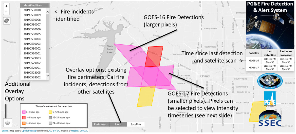
PG&E fire detection and alert system. PG&E illustration.

The following information was released by the California-based Pacific Gas and Electric Company which describes a system they have developed to extract near real time fire detection data from satellites, such as the GOES 16 and the new GOES 17. Scott Strenfel, a Senior Meteorologist at PG&E, said   they are planning to make the data public within a month or two, which may be the first public tool available with GOES-R fire detections.


SAN FRANCISCO –– After several years of testing and development, Pacific Gas and Electric Company (PG&E) has deployed the PG&E Satellite Fire Detection and Alerting System.

The Satellite Fire Detection and Alerting System is a state-of-the-science program that incorporates data from the two new GOES satellites, as well as three polar orbiting satellites, to provide PG&E with advanced warning 24/7 of potential new fire incidents. The satellites are operated by the United States’ National Oceanic and Atmospheric Administration (NOAA)’s National Environmental Satellite, Data, and Information Service division.

“This capability offers first-of-its-kind situational awareness by providing a live feed from the satellites to our Wildfire Safety Operations Center. Emerging technologies such as this are another way we are working to reduce wildfire risk and protect our customers and our communities,” said Sumeet Singh, Vice President of PG&E’s Community Wildfire Safety Program.

The PG&E Meteorology Team led development of the program in collaboration with experts in the satellite fire detection field from the University of Wisconsin–Madison Space Science and Engineering Center (SSEC). The system became fully operational in late June.

PG&E fire detection and alert system
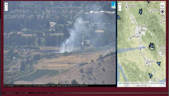
PG&E fire detection and alert system.

Working with the SSEC, PG&E developed a dedicated and proprietary data pipeline that provides fire detection data as fast as every minute. An internal web application allows staff at PG&E’s Wildfire Safety Operations Center to track fire progression as well as the intensity of fires in near real time. The system also generates new fire alerts via email and on an app. The system has already detected hundreds of fires since it began limited operation in February.

If a fire is detected from two or more satellites, such as GOES-16 and 17, then confidence is high of an actual fire in the area. In many cases this system is expected to provide an early, if not the first, indication of an incident.

Community Wildfire Safety Program

By the end of 2019, PG&E plans to have at least 600 weather stations and 100 high-definition cameras in high fire-threat areas. These new installations are one of the additional precautionary measures the company is implementing following the 2017 and 2018 wildfires to further reduce wildfire risks.

Red Flag Warnings for lightning in four western states

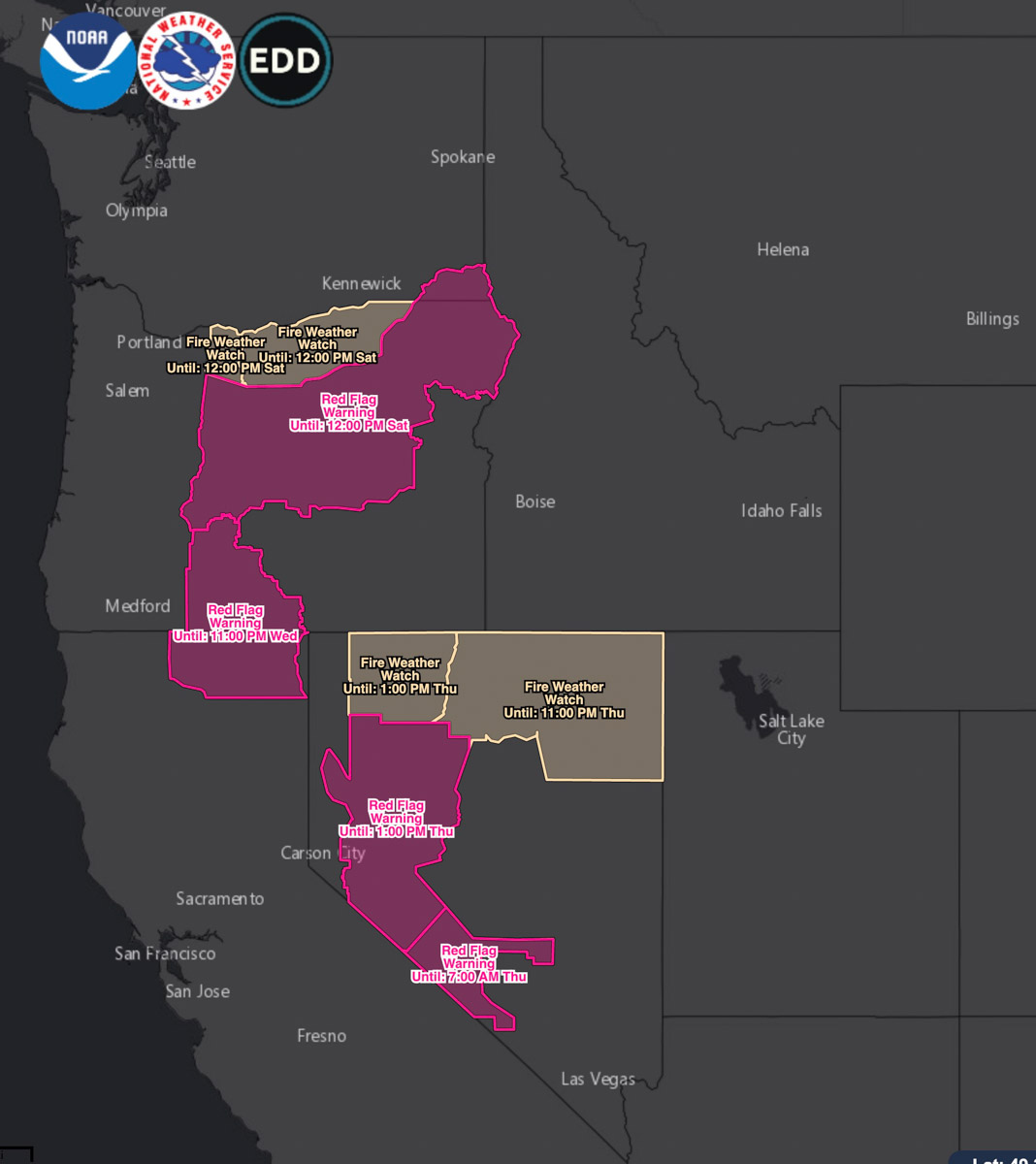
Red Flag Warnings
Red Flag Warnings issued August 7, 2019.

The National Weather Service has issued Red Flag Warnings and Fire Weather Watches for elevated wildfire danger on August 7, 2019 for areas of California, Nevada, Oregon, and Washington.

The forecasts for these areas include thunderstorms and in some cases, lightning described as “abundant”.

(Red Flag Warnings can be modified throughout the day as NWS offices around the country update and revise their weather forecasts.)