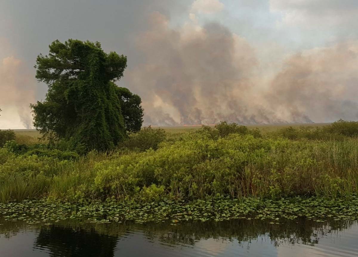
Rain slows spread of 42,000-acre Sawgrass Fire in Florida

map Sawgrass Fire Florida
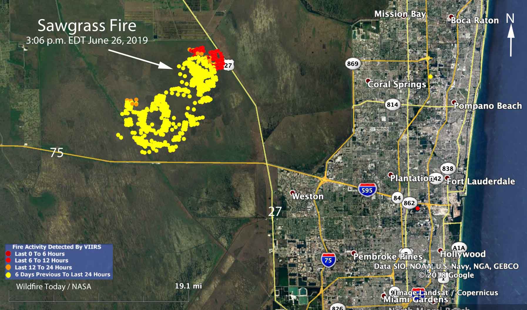
Map showing heat detected by a satellite over the Sawgrass Fire at 3:06 p.m. June 26, 2019. The red areas are the most recently burned.

Rain off and on throughout the day on Wednesday accompanied by 97 percent relative humidity slowed the spread of the Sawgrass Fire in South Florida nine miles northwest of Weston.

Friday evening the Florida Forest Service mapped the fire at 42,000 acres. An aircraft will fly it again Thursday morning to get an updated size.

The winds Wednesday on the fire were variable, but were mostly out of the west and northwest, contrary to the forecast which predicted east or northeast winds which would have pushed the smoke away from the densely populated areas on the east side of south Florida.

As you can see on the map, the satellite detected little or no heat on the south and west sides of the fire during the Wednesday afternoon overflight. Clouds in the area prevented any later heat data from the satellite. The fire has approached State Highway 27 and the high voltage power lines on the west side of the road. This could be a result of natural spread due to the west and northwest wind, or possibly combined with a firing operation by the ten firefighters and the Type 5 Incident Commander assigned to the incident.

A weather station 15 miles northeast of the fire recorded 0.05 inch of rain Wednesday, but a couple of stations to the southwest received two or more inches, indicating thunderstorms moving through the area. There is only a 15 percent chance of rain on Thursday, but precipitation is much more likely during each of the following seven days.

If the forecast turns out to be accurate, the demise of the Sawgrass Fire seems likely in the next few days.
Satellite photo Sawgrass Fire
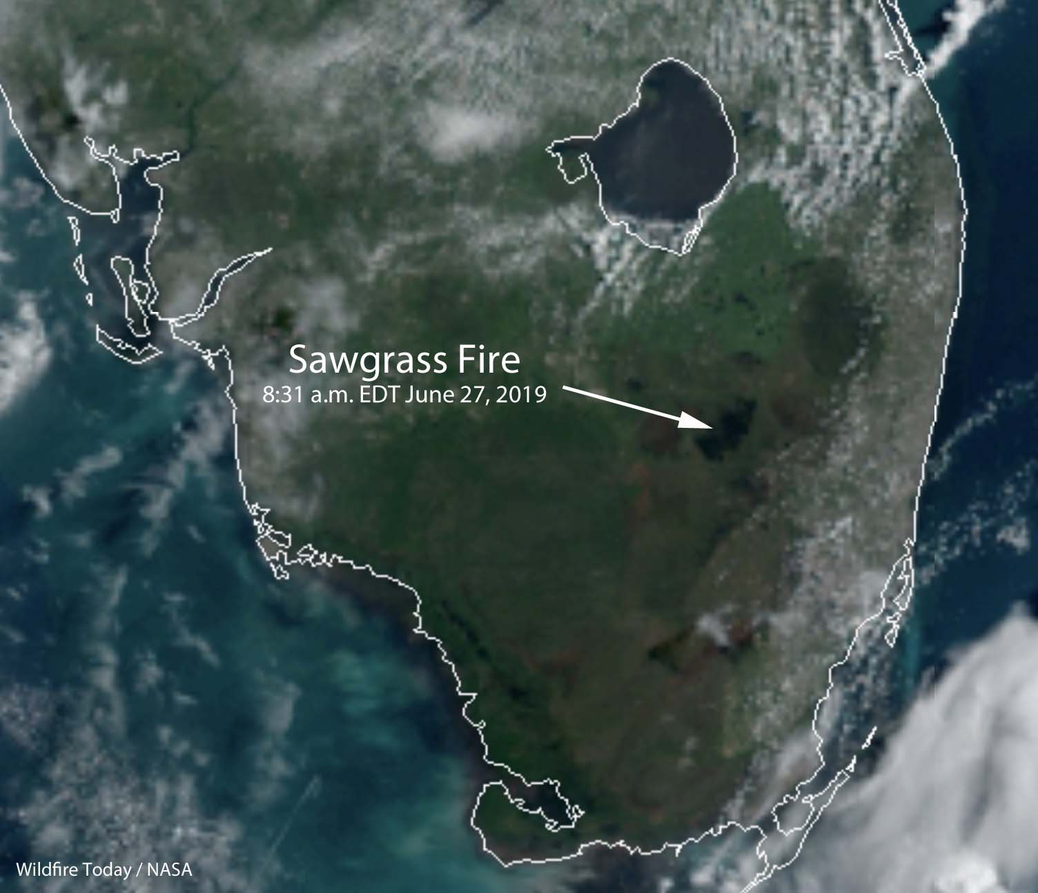
Satellite photo of South Florida at 8:31 a.m. EDT June 27. The area burned in the Sawgrass Fire is at the end of the arrow.

NWCG wants your thoughts about the document that replaced the Fireline Handbook

The National Wildfire Coordinating Group’s Operations and Training Committee wants you to take an online survey about the Wildland Fire Incident Management Field Guide, PMS 210, that replaced the Fireline Handbook in 2013.

Survey Question fireline handbook
Question number one in the survey.

Since it is Throwback Thursday, here is what we wrote about the transition April 29, 2013:


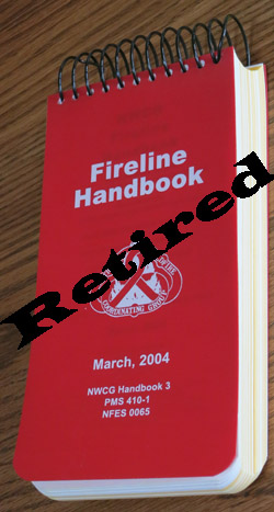
Fireline HandbookThe Fireline Handbook has been retired and replaced with an electronic file, a .pdf, called Wildland Fire Incident Management Field Guide (PMS 210).

May it rest in peace.

A memo released by the National Wildfire Coordinating Group (NWCG) suggests that the new 148-page document “can be printed locally in a standard 8½” x 11”, three-ring binder format.”

When it was first introduced, the Fireline Handbook, PMS 410-1, was appropriately named, fitting easily in your hand and pocket. Over several decades it became bloated as committees kept adding everything they could think of to it until it was over an inch thick and weighed almost a pound (15 ounces). It grew to 430 pages without the optional Fire Behavior Appendix and barely fit into a pants pocket. It was last updated in 2004.

The Fireline Handbook has become less valuable as other reference guides have been introduced, including the The Incident Response Pocket Guide (IRPG) and the Interagency Standards for Fire and Fire Aviation Operations, better known as the Red Book. The newer guides had some of the same information as the Fireline Handbook.

The Wildland Fire Incident Management Field Guide still has some information that is duplicated in the Incident Response Pocket Guide (IRPG) and FEMA’s National Incident Management System Emergency Responder Field Operating Guide (ERFOG), but according to the NWCG, which published the new guide, the documents have different purposes and user groups.

Wildfire Today first wrote about the possible demise of the Fireline Handbook in March, 2011.

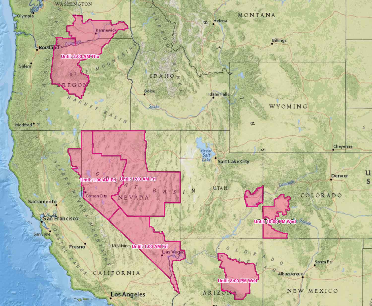
Red Flag Warnings in effect June 26, 2019

Red Flag Warnings are in effect for elevated wildfire danger in areas of Washington, Oregon, California, Nevada, Utah, Colorado, and Arizona. As you can see on the map they expire at various times Wednesday, Thursday, or Friday.

Red Flag Warnings, June 26, 2019
Red Flag Warnings issued June 26, 2019. Click to enlarge.

(Red Flag Warnings can be modified throughout the day as NWS offices around the country update and revise their weather forecasts.)

Class action suit filed over health effects of burning sugar cane

Burning field sugar cane
Burning a field of sugar cane in Hawaii. Photo by bob Bangerter.

A class action lawsuit was filed in Florida Tuesday over the health effects of burning sugar cane fields.

The four people at the front of the room where the legal action was announced included, in addition to an attorney and a state legislator, Frank Biden, brother of former Vice President Joe Biden, and former Jacksonville Jaguars running back Fred Taylor.

Fields of sugar cane are sometimes burned before manual harvesting in order to remove the dry leaves and chase away or kill any lurking venomous snakes.

Below are excerpts from an article at the Sun-Sentinel:

There have been more than 100,000 cane field burns in Palm Beach County since 2004, according to former state Sen. Joe Abruzzo, who now serves as the director of government relations at the Berman Law Group, which filed the suit.

According to Abruzzo, there are also 700 hospitalizations for asthma in Palm Beach County for every 100,000 residents. That’s significantly higher than statewide numbers. According to the Centers for Disease Control, the hospitalization rate for asthma in Florida is 142.4 out of 100,000.

“The sugar companies, they have to take responsibility for this. If nothing more, they need to promote awareness and get down to the bottom of these health issues because the community is dying,” Taylor said. “The black snow that comes from the sky, people are breathing that stuff in. They’re getting sicker and sicker every day.”

The lawsuit accuses U.S. Sugar, Florida Crystals and other sugar producers of negligence, liability for any damages caused by the burning of the fields, and trespassing in that hazardous waste landed on the property of members of the class-action suit, among other things. The suit asks the court to institute a medical monitoring program for residents of Belle Glade, South Bay, Pahokee and nearby areas, as well as asking the court to force sugar companies to stop any future crop burnings.

Thanks and a tip of the hat go out to Bob. Typos or errors, report them HERE.

Sawgrass Fire in Florida briefly closes Interstate 75

The fire has burned 41,500 acres 9 miles northwest of Weston

Sawgrass Fire everglades Florida
Sawgrass Fire. Photo by Florida Forest Service June 25, 2019.

(Originally published at 11:36 a.m. EDT June 25, 2019)

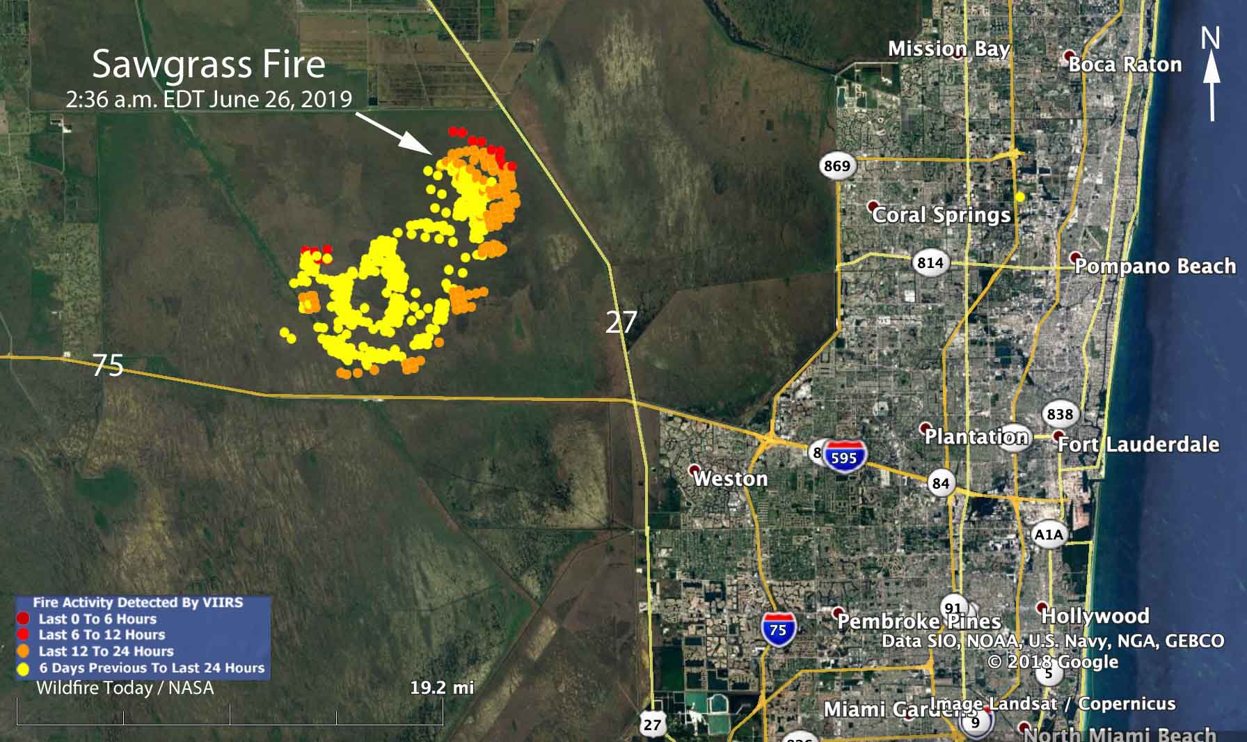
The Sawgrass Fire in the south Florida everglades required the closure of Interstate 75 for about 10 minutes Tuesday when smoke affected visibility on the highway. A light rain slowed the movement of the blaze and reduced the smoke, allowing the highway to reopen. As you can see in the map below, a satellite was still able to detect heat during a 2:36 a.m. overflight Wednesday.

map Sawgrass Fire everglades Florida
Map showing heat detected by a satellite over the Sawgrass Fire at 2:36 a.m. June 26, 2019. The red areas are the most recently burned.

Since the fire started from a lightning strike Sunday afternoon it has burned 33,500 acres of state-protected land as of Tuesday evening, according to the Florida Forest Service. The land in the area is managed by the South Florida Water Management District. (UPDATE at 2:05 p.m. EDT June 26, 2019: The Florida Forest Service has revised the estimated size to 41,500 acres.)

Four firefighters are assigned to the fire, led by a Type 5 Incident Commander.

The blaze is about one mile away from both Interstate 75 and State Highway 27. The objective is to keep the blaze within the 165,000-acre conservation area that is bordered by canals, said Scott Peterich, a spokesman with the Florida Forest Service’s Everglades District.

For the last couple of days the smoke has been moving to the northeast, somewhat sparing the community of Weston located 9 miles southeast of the fire. The forecast through Friday calls for east or northeast winds that will push the smoke away from the densely populated areas on the east side of south Florida. There is a 40 to 50 percent chance of rain Wednesday and Friday.

Check out the video of a drone flying through the fire:

Sawgrass Fire everglades Florida
Sawgrass Fire. Photo by Florida Forest Service June 24, 2019.