National Park Service Regional Aviation Manager and Safety Manager killed in Alaska plane crash

Posted on Categories UncategorizedTags ,

The two men died May 27 in the accident near Whitehorse International Airport

(From the National Park Service, May 29, 2019)

The National Park Service (NPS) is mourning the loss of two of its Alaska-based employees following an airplane crash in Whitehorse, Canada on Monday evening.

The two men, Jeff Babcock and Charles Eric Benson, were on a personal trip to ferry a privately-owned airplane from the Lower 48 to Anchorage, Alaska, when the plane went down shortly after take-off from Whitehorse International Airport.

According to Canadian officials and witnesses the airplane crashed at about 5:30 p.m. Monday shortly after takeoff into a forested area south of the airport. A column of smoke was seen rising from the area and emergency personnel from Whitehorse Fire Department, the Whitehorse RCMP and airport firefighters responded immediately to the scene.

Jeff Babcock served as the NPS Alaska Region Aviation Manager and Charles Eric Benson was the NPS Alaska Region Safety Manager. “Jeff and Eric were two of our very best and the National Park Service and Alaska Region have suffered a terrible loss,” said Bert Frost, NPS Alaska Regional Director. “Our thoughts and prayers are with the families of Jeff and Eric and we are heartbroken,” said Frost.

Both men were accomplished professionals, as well as skilled airmen. Prior to working for the National Park Service:

Jeff Babcock had a distinguished 23-year career as a Sergeant, Lieutenant, and Captain in the Alaska State Troopers where he served as a Commercial Pilot, Aircraft and Vessel Section Supervisor, Use of Force Instructor, Accident Reconstructionist, Undercover Investigator, Internal Investigator, Tactical Dive Master, Firearms Instructor, and Certified Flight Instructor. After retiring from the Alaska State Troopers, and before coming to work with the National Park Service, Jeff flew for 7 years as a pilot for K-2 Aviation. He enjoyed flying guests around Mt. Denali and sharing with them his favorite parts of Alaska.

Eric Benson served for 25 years in both the U.S. Air Force and in the U.S. Army in a variety of assignments. From 1993-1994 he attended and graduated from the Initial Entry Rotary Wing Qualification and the Aviation Officer Basic Courses at Fort Rucker Alabama. He then served as a UH-60 Army Aviator, Platoon Leader, Company Executive Officer, Brigade Aviation Element, and an Aviation Maintenance Company Commander. Eric’s active duty career culminated in December of 2007, with the 10th Mountain Division while serving as a Battalion Executive Officer for the General Support Aviation Battalion at Fort Drum, New York. He joined the National Park Service after retiring from the U.S. Army.

Jeff Babcock and Eric Benson were long-time residents of Alaska and are well-known throughout the state. Services for Jeff Babcock will be held on Saturday, June 1, 2019 at The Church of Jesus Christ of Latter-Day Saints, The Colony Chapel, 9475 East Silver Springs Circle, Palmer, Alaska at 11:00 a.m. Everyone is welcome to attend. Private services are pending for Eric Benson.

Jeff Babcock killed plane crash Alaska
Jeff Babcock. NPS photo.
Eric Benson killed plane crash Alaska
Eric Benson. Photo courtesy of the Benson family.

Comparing prescribed fire activity across the United States

Trying to compare the acres treated with prescribed fire in California and Florida is like comparing apples and penguins. In addition to California’s significant regulatory issues, the vegetation there is more explosive (in some areas), the terrain complicates ignition, and the road systems and access can sometimes be challenging. By comparison Florida is flat, access is usually much easier, and the fuels are not as difficult for an experienced prescribed fire crew to safely ignite.

But with the increased wildfire activity in recent decades and pressure from many sources to treat hazardous fuels and rake the forests, more attention is being focused on prescribed fire as one way to mitigate the effects of climate change. However the number of acres treated on federal lands is directly related to the funds appropriated for that purpose. And those dollars have been relatively flat for a number of years.

Climate Central put together some interesting graphics. (Click on the images twice to see larger versions and more tweets in the thread.)

Map showing 10 days of precipitation helps explain widespread flooding

Cumulative precipitation 10-day period
Cumulative precipitation over the 10-day period ending Mary 29. NWS data processed by Wildfire Today. Click to enlarge.

This map showing cumulative precipitation over the 10-day period ending May 29 helps explain some of the recent widespread flooding in the middle of the country. It looks like a few areas had more than 12 inches. Many locations had more than 6.

(I don’t know why data for those five western states does not show up.)

Satellite photo showing the three major fires active in Northern Alberta

wildfires in Northern Alberta May 28, 2019 Satellite photo
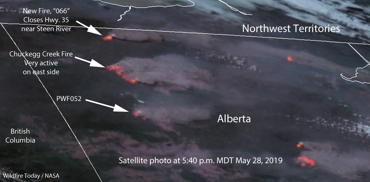
Satellite photo showing the location of wildfires in Northern Alberta May 28, 2019. Click to enlarge.

This satellite photo taken at 5:40 p.m. MDT April 28 shows the locations of three major wildfires in Northern Alberta. The imagery was enhanced to enhanced to show the heat generated by the active fires.

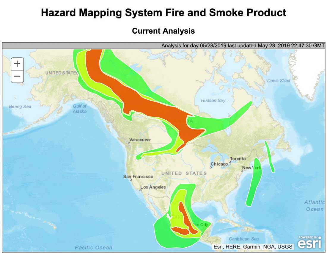
As predicted, the wind on Tuesday was out of the west which made the east sides of the fire more active than they had been in recent days. As you can see in the photo large amounts of smoke are flowing off to the east. Click here to see an analysis and map of wildfire smoke in North America today.

The northern-most fire identified on the map is a relatively new blaze, known as “066”. Alberta Wildfire said Tuesday afternoon,  “[The fire] is approximately 6 km west of Highway 35 near Steen River. Highway 35 North of High Level is closed due to smoke – monitor Alberta511 for updated highway conditions.”

The air quality in the town of High Level, Alberta has reached dangerous levels.

Wildfire smoke map for North America

wildfire smoke map North America may 28 2019
The distribution of smoke from wildfires in North America, May 28, 2019. Click to enlarge.

The air quality in the town of High Level, Alberta has reached dangerous levels.