Tasmania to review the 2018-2019 bushfire season

Posted on Categories Uncategorized
wildfires in Tasmania satellite photo
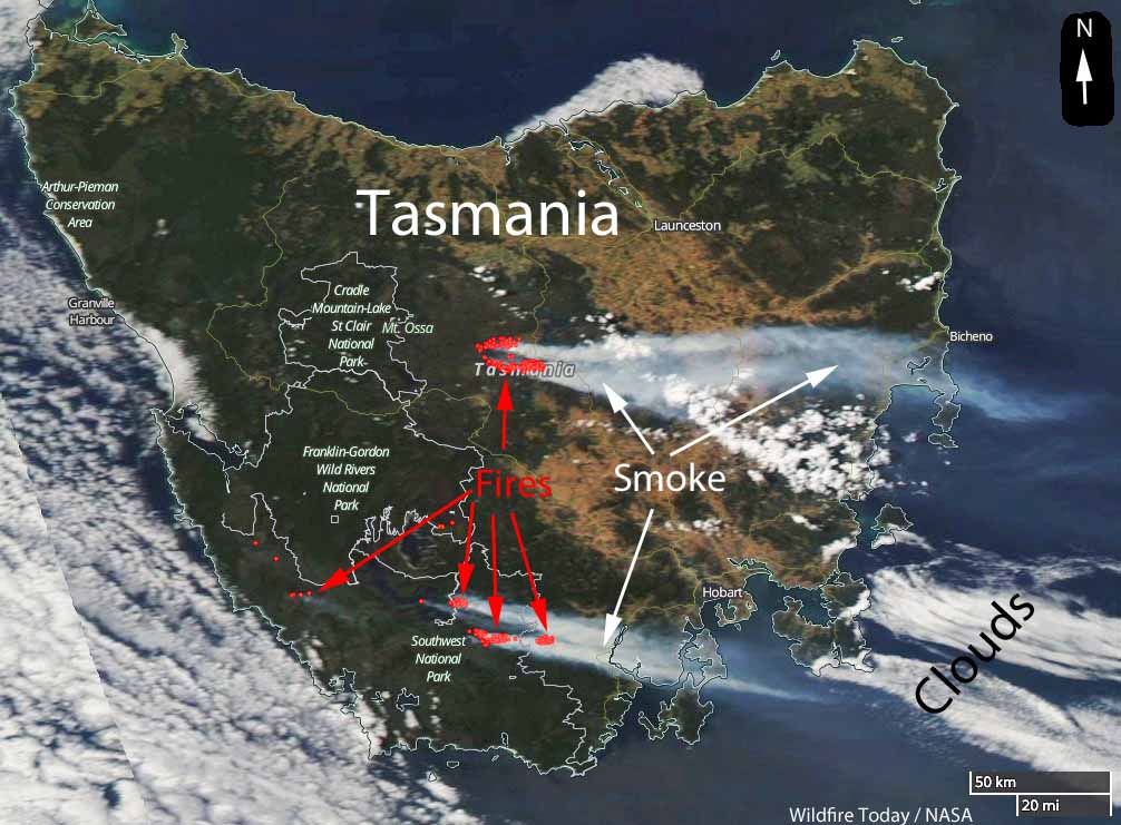
Satellite photo of smoke from wildfires south of Australia in Tasmania, January 21, 2019. The red dots represent heat detected by the satellite. NASA & Wildfire Today.

The government of Tasmania will be conducting an independent review of their 2018-2019 bushfire season which saw far more acres burned in the state than in an average year.

Below is the announcement issued March 30, 2019 by the Premier, Will Hodgman.


Today, the Tasmanian Government has released the Terms of Reference for the Independent Review into 2018-19 bushfires as a key part of the bushfire recovery process.

The review will consider the following matters:

  • The causes, chronology and response of the 2018-19 bushfires in Tasmania on and following 28 December 2018.
  • The effectiveness of community messaging and warnings.
  • The timeliness and effectiveness of the fire response and management strategy, including accommodating the priorities of life, property, environmental and cultural values, and timber production and forest asset values by Tasmanian fire agencies.
  • The impact and effectiveness of fuel management programs in the fire affected areas on the management and containment of the fires.
  • The effectiveness of state, regional and local command, control and co-ordination arrangements, to include agency interoperability and the co-ordination of emergency management activities with government and non-government organisations.
  • The effectiveness of the arrangements in place for requesting and managing interstate and international assistance and the significance of interstate and international assistance in managing the fires.
  • The use and effectiveness of aviation firefighting resources, in particular, the suitability of aircraft types for the protection of environmental values, forest assets and the rural/urban interface in Tasmania.
  • Any other matter that the Review team identifies in the course of its activities as warranting discussion.
  • The Review team will provide a means for members of the public and other interested parties to make submissions to the Review and will have regard to any submissions received in compiling its report.

As previously announced, the Review will be chaired by Mal Cronstedt AFSM who will be joined on the Review team by;

  • Guy Thomas – Director of Asset Services with the Queensland Parks and Wildlife Service.
  • Paul Considine – Director of Capability and Assurance at Australasian Fire and Emergency Services Authorities Council.

Public submissions will be called for on 6 April 2019 and there will be a four week consultation period closing on 3 May 2019. Members of the public will be able to lodge formal submissions or make an appointment to talk in person or on the phone to the Review team.

The Terms of Reference and details of the Review will also be available on the Department of Police, Fire and Emergency Management’s website at www.dpfem.tas.gov.au

The final review is expected to be delivered to Government by July this year.


Thanks and a tip of the hat go out to Bean. Typos or errors, report them HERE.

Why people love firefighters

Firefighters, especially wildland firefighters, will enjoy comedian Roy Wood Jr’s jokes about why people love firefighters.

You can’t be cooler than a firefighter. The only person cooler than a firefighter is a forest firefighter. That’s next level. It’s basically CrossFit. It’s the X Games of firefighting.

27 firefighters and 3 others confirmed killed in wildfire in China

The fire was burning at 12,000 feet above sea level

China 27 firefighters killed wildfire
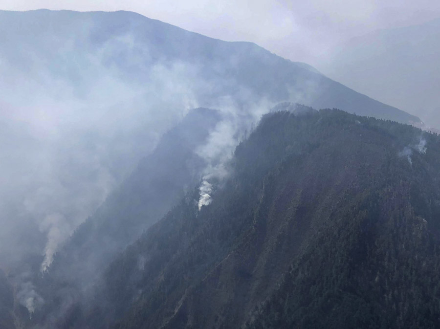
Photo taken on April 1, 2019 shows the site of a forest fire in Yalongjiang Township of Muli County, Liangshan Yi Autonomous Prefecture, southwest China’s Sichuan Province. Twenty-seven firefighters have been confirmed as having died March 31 while working on the fire.

China’s state news agency Xinhua confirmed Tuesday that 27 firefighters and 3 locals lost their lives March 31 while battling a wildfire in southwest China’s Sichuan Province.

The agency said the fire burned 15 hectares (37 acres) in a remote area of the province at 3,700 meters (12,139 feet) above sea level.

“We’re ready to increase precipitation artificially,”said Wu Song, county chief of Muli, Sichuan’s Liangshan Yi Autonomous Prefecture. He said the fire has been contained as of Tuesday.

china wildfire helicopter water bucket
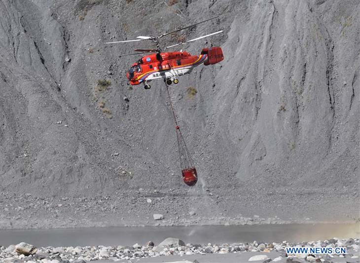
A firefighting helicopter collects water to battle a forest fire in Muli County in Liangshan Yi Autonomous Prefecture, southwest China’s Sichuan Province, April 2, 2019.

Another fire in China, in Shanxi Province, is being fought by over 15,000 people, including professional firefighters, factory workers, soldiers, and police. Residents of 41 villages are under evacuation orders. The state news agency said “Firefighters have carved out a 40-km-long isolation belt. A second 6-km-long fire isolation belt is being bulldozed.”

Wildfire potential, April through July

The outlook predicts above normal potential for western Washington and northwest Oregon

April 2019

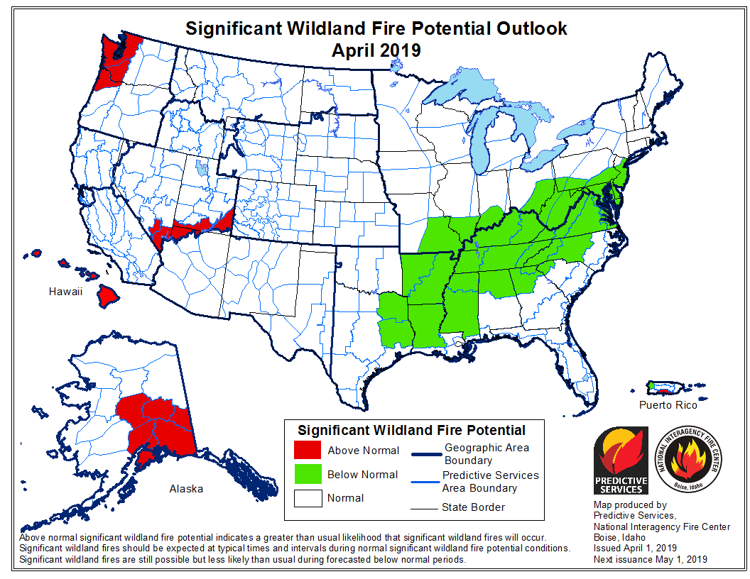
On April 1 the Predictive Services section at the National Interagency Fire Center issued their Wildland Fire Potential Outlook for April through July. The data represents the cumulative forecasts of the ten Geographic Area Predictive Services Units and the National Predictive Services Unit.

If NIFC’s analysis is correct, western Washington and northwest Oregon should see above normal wildfire activity through mid-summer. In June wildfire potential should pick up in the coastal mountains of California while most of the Sierra Nevada Mountains are expected to have below normal activity during those two months.

Below:

  • An excerpt from the NIFC narrative report for the next several months;
  • More of NIFC’s monthly graphical outlooks;
  • NOAA’s three-month temperature and precipitation forecasts; and,
  • Drought Monitor.

“As the spring greenup begins to take hold across the West in April, mountain snowpack will begin to melt. Snowpack melting rates are a more important factor than snowpack levels in assessing potential fire season activity ahead. An average or slower than average melting rate can allow for a late entry of the timbered elevations into the fire season, whereas a faster melting rate will allow for high elevation fuels to become receptive to fire sooner. In 2019, an average to cooler than average spring is expected, so melting rates should be near average which could result in a delayed fire season entry in areas that have abundant snowpack. An early entry is possible along the Canadian border in areas that have a below average snowpack. In the middle and lower elevations, abundant winter and spring moisture should translate to a heavy crop of fine fuels that will become increasingly receptive to fire activity across the West from south to north in May, June, and July.

“In Alaska, warmer than average temperatures should lead to an early snowpack loss and early entry into the fire season. A possibility exists that precipitation could become above average from June onward. This could lessen some of the state’s peak season fire potential during the second half of the season. After an active early start to the season, fire activity across the state should trend toward average conditions. Hawaii and Puerto Rico will continue to see slightly elevated potential early in the outlook period until the impacts of tropical weather conditions begin to be felt. The Southwestern fire season should begin to end in early July as a below average and perhaps late monsoon arrives.”

May 2019
Continue reading “Wildfire potential, April through July”

Report: 27 wildland firefighters killed in China

wildfire killed firefighters china
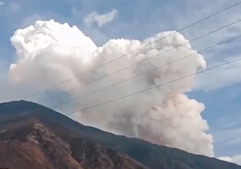
The deadly wildfire in southwestern China. New China photo.

Early reports are that at least 27 firefighters were killed while fighting a wildfire in China on March 31. The BBC said 30 firefighters died, while the China Xinhau News reported it was 27 firefighters and 3 civilians that perished.

(Update 9:15 a.m. MDT April 2: China’s state new agency Xinhua confirmed Tuesday that 27 firefighters and 3 locals lost their lives.)

From the BBC:

Thirty firefighters have died while tackling a huge forest fire in south-western China, officials say.

Fire crews had been battling the blaze in the mountains of Sichuan province on Sunday when a change in wind direction caused “a huge fireball”, trapping them, the emergency ministry said.

Contact with 30 firefighters was lost. All were confirmed dead on Monday and their bodies were retrieved from the mountain, state TV said.

China Xinhua News had different numbers — 30 killed but 27 of those were firefighters.

An earlier report had the number at 26 firefighters:

The New York Times was not specific about how the numbers broke down:

A forest fire in southwestern China turned deadly over the weekend when winds shifted unexpectedly, trapping firefighters and local officials in a maelstrom. The bodies of 30 people who could not escape were found on Monday, officials announced, even as the fire continued to burn out of control.

Among those who died were the chief of a regional forestry bureau in Liangshan Yi Autonomous Prefecture in Sichuan Province, and his deputy, state media reported. The officials had traveled to the scene of the fire, which broke out on Saturday in a remote location at altitudes nearing 13,000 feet, and had not been heard from since.

Our sincere condolences go out to the families, friends, and coworkers of the deceased.

Thanks and a tip of the hat go out to Paula. Typos or errors, report them HERE.
Social media can help identify evacuation patterns

Data can help determine when people relocate in or out of an evacuation area

social media evacuation pattern Ranch Fire wildfire
August 5, 2018

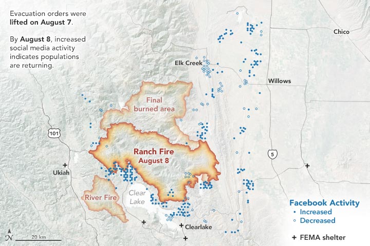
In July 2018, a spark near the Mendocino National Forest ignited California’s largest wildfire on record. As the Ranch Fire spread rapidly, officials declared mandatory evacuations in several areas and counties. But where did people go, when did they leave, and when did they return? Researchers have turned to a new data source to observe population movements during a crisis: social media.

“We wanted to analyze evacuation patterns and factors that can influence the speed of evacuations during a crisis,” said Shenyue Jia, a remote sensing specialist at Chapman University.

Analyzing evacuation and recovery patterns could help researchers understand how humans behave in the face of a disaster, which could inform emergency response efforts. Jia said nobody was able to provide population movements during a disaster, especially at a high temporal and spatial resolution—until Facebook.

Almost 2.5 billion people per month actively use Facebook. When a disaster strikes, many of those users log on during an evacuation. Facebook’s disasters map initiative uses aggregated, anonymized Facebook data in disaster areas to estimate population densities, movements between neighborhoods, and where people mark themselves as “safe” during a crisis. The company also works with mobile phone carriers to observe the number of connections to surrounding cell phone towers.

social media evacuation pattern Ranch Fire wildfire
August 8, 2018

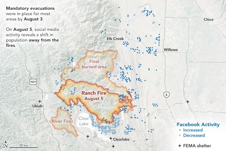
The images on this page show the population data during the Mendocino Complex Fire in Northern California for 10,000 people, as provided by the Facebook disaster map dataset. The first map above shows the area on August 5, 2018, two days after mandatory evacuations were in place. The second map below shows the area on August 8, one day after the evacuation orders were lifted.

During the Mendocino Complex fire, most people fled the fire perimeter when an evacuation was in place, which was not surprising. But what surprised Jia was where people were headed—or not headed.

“Originally, I thought this data could be nice to track which places people decide to go, but the information didn’t show any significant pattern for this fire,” said Jia, whose research was funded by NASA. “I was expecting a very simple trend, but evacuations are more complicated to understand.”

Jia thinks that perhaps people had more shelter options to flee to (FEMA shelters, neighboring towns, etc.), so the evacuation patterns were dispersed.

However, when the evacuations were lifted, the data showed a much clearer trend of where people were headed: most were returning back to their homes and hometowns. Jia said that how the population bounces back post-disaster is an important indicator of whether the evacuated areas may be safe for residing. In the Mendocino Complex fire, most areas saw people returning.

But that’s not always the case. Jia also analyzed population data from Facebook for the Camp Fire that occurred in November 2018. The data showed a large portion of the evacuated area did not see a sustainable population return since many of those areas were destroyed.

“This research demonstrates that social-network data can be a valuable tool to monitor human behaviors in response to disasters, such as wildfires in areas that have been exacerbated by urbanization,” said Son Nghiem, remote sensing expert at NASA’s Jet Propulsion Laboratory, who oversaw this research.

According to Nghiem, this frequently updated social media data can add another dimension to satellite remote sensing data from NASA and other international agencies used to monitor land cover and land use change.

“With remote sensing data, we don’t know the immediate socioeconomic and demographic impacts,” said Nghiem. “This innovative use of demographic data opens up new possibilities to advance research on how humans respond to abrupt physical changes in disaster situations.”

This article first appeared on the NASA website. NASA Earth Observatory images by Joshua Stevens, using data courtesy of Shenyue Jia/Chapman University. Story by Kasha Patel.