Officials confirm 33 homes destroyed at the Tinder Fire

At least 54 outbuildings also burned, for a total of 87 structures

Above: Snow at the Tinder Fire Incident Command Post, May 2, 2018. IMT photo.

(Originally published at 1:55 p.m. MDT May 4, 2018)

The Incident Management Team reported Friday morning that 33 residences and 54 outbuildings burned in the Tinder Fire, which started a week ago 22 air miles northeast of Payson, Arizona.

(To see all articles on Wildfire Today about the Tinder Fire, click here.)

By sunset today, May 4, all evacuation orders will be lifted on the 12,628-acre blaze. Displaced residents are being allowed into the communities during a staged re-entry process beginning with those whose homes burned. Highway 87 will reopen at 7 p.m. today.

Firefighters are conducting burnout operations today on the northeast and east sides as conditions allow to further secure unburned interior islands within the fire perimeter.

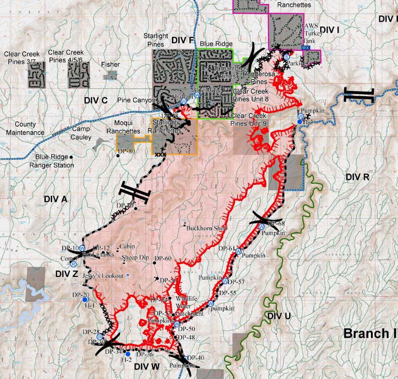
map Tinder Fire MAY 3, 2018
Incident Management Team map of the Tinder Fire May 3, 2018. The black lines represent areas where the fire is held by a road, dozer line, or hand-constructed fireline. The red lines are open fireline. Click here to see the original map with a legend.

1,500-acre fire at Malheur NWR

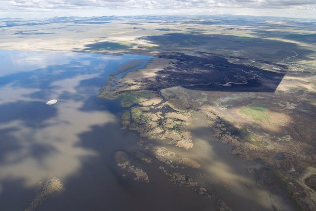
Above:  The Voltage Fire, undated photo, credit: U.S. Fish & Wildlife Service.

Firefighters are making progress on a wildfire that started April 27 in Malheur National Wildlife Refuge in Oregon, but it sounds like there will be extensive mopup since it is burning in heavy tule marsh vegetation. Firefighters are using roads, canals, open water, and nonburnable vegetation for control opportunities.

Voltage Fire
Voltage Fire. Photo credit: Peter Pearsall, Friends of Malheur National Wildlife Refuge.

Here is the latest information about the Voltage Fire issued Thursday by the Refuge:

The fire started April 27 from a lightning strike, and burned approximately 1,500 acres. Firefighters are continuing to suppress the wildfire in organic soils, and will be conducting interior burn out operations today to remove the immediate threat to control lines. Photo credit: Peter Pearsall, Friends of Malheur National Wildlife Refuge.

Voltage Fire Malheur National Wildlife Refuge
Photo by Kay Steele

McDannald Fire mapped at 22,000 acres

The fire is 13 miles west of Fort Davis, Texas.

Above: Map of the McDannald Fire showing the approximate perimeter early Thursday morning May 3, 2018.

(Originally published at 8:43 a.m. CDT May 3, 2018)

The McDannald Fire in western Texas slowed Wednesday and officials were able to lift the voluntary evacuations that were in effect for the Davis Mountain Resort area.

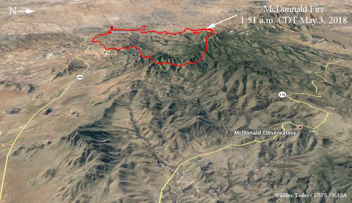
A mapping flight at about 2 a.m. Thursday estimated the fire had burned 22,053 acres.

Jeff Davis County released the following information Wednesday evening:

With the cooler temperatures and higher humidity today the McDannald Fire has shown minimal fire growth. The east side of Paradise Ridge has little fire activity at this time and the head of the fire appears to be north of the Davis Mountain Resort.

Given these conditions, the County Judge and County EMC will lift the voluntary evacuation order at 8:00 PM this evening. Residents will be allowed back in after that time.

We appreciate the cooperation of all residents. Your actions allowed the structure crews in the Davis Mountain Resort to perform their work with minimal trouble.

map of the McDannald Fire 3d wildfire
3D map of the McDannald Fire showing the approximate perimeter early Thursday morning May 3, 2018.

Light rain and snow on the Tinder Fire in Arizona

Personnel are mopping up in some areas, but Southwest Incident Management Team #1 reports “zero percent” of the fireline is contained.

The Tinder Fire between Payson and Winslow Arizona received light rain and snow over the last 24 hours. This raised the humidity and a satellite overflight early Wednesday morning detected no large heat sources. However, cloud cover may have blocked the sensors on the satellite. A fixed wing mapping flight scheduled overnight had to be cancelled due to weather.

(To see all articles on Wildfire Today about the Tinder Fire, click here.)

On Tuesday fire crews burned off seven miles of existing Forest Service roads to create continuous containment lines from along the west flank. Wednesday’s objective is to carry this new containment line north to Mogollon Ranchettes.

Fire crews working with the support of Type 1 heavy helicopters built containment line entirely around the spot fire near Leonard Canyon Tuesday. They were able to hold the spot at approximately 5 acres. As conditions allow, helicopters will continue with water drops to suppress remaining heat.

Coconino County will be notifying property owners about structures that have been damaged or destroyed.

The Coconino County Sheriff’s Office evacuation for all Blue Ridge Tinder Fire affected communities north, east and west of Hwy 87 remains in effect. The evacuation will remain in effect until firefighters are able to contain the west and north flanks of the fire and are confident there is no longer a threat to communities.

FEMA Region 9 and other sources are reporting that the fire was caused by an abandoned illegal campfire.

After the precipitation, personnel are mopping up further into the burn area in some areas rather than having to concentrate on building fireline. But Bea Day’s Incident Management Team (IMT) on Wednesday reported “zero percent containment” on the fire. According to the National Wildfire Coordinating Group’s Glossary, 100 percent containment would be when “a control line has been completed around the fire, and any associated spot fires, which can reasonably be expected to stop the fire’s spread”. If, for example, 10 percent of the fire perimeter has fireline (where fuel has been removed) and that section of the perimeter is not likely to spread, some IMTs will call it 10 percent contained. Other teams release to the public a containment figure using very different criteria. This is why Wildfire Today rarely includes containment percentages, since they can be meaningless.
McDannald Fire is very active west of Fort Davis, Texas

Posted on Categories UncategorizedTags ,

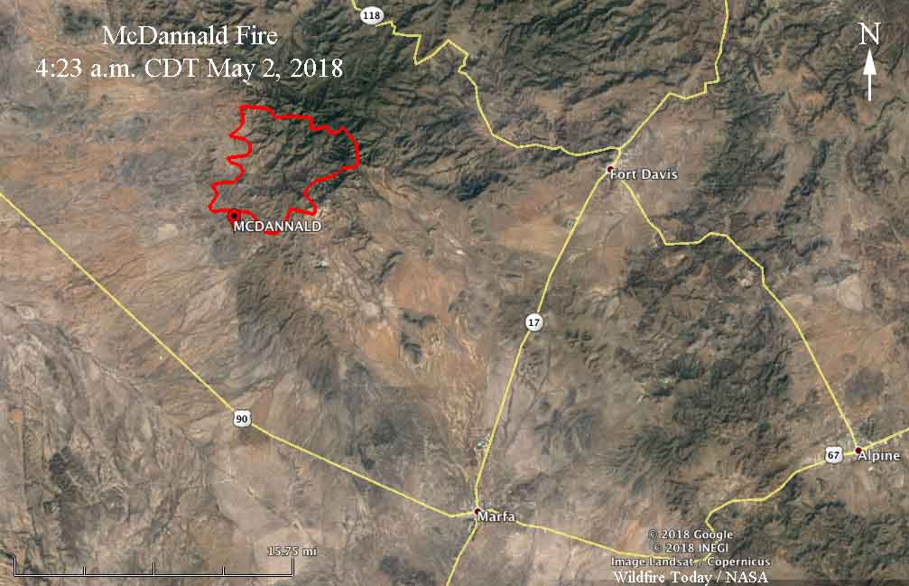
Above: 3D map of the McDannald Fire showing the approximate perimeter at 4:23 a.m. CDT May 2, 2018.

(Originally published at 10:55 a.m. CDT May 2, 2018)

The McDannald Fire 13 miles west of Fort Davis, Texas was very active Tuesday and early Wednesday morning. Pushed by 10 to 20 mph winds out of the south and southwest it spread to within a mile west of Tomahawk Trail on the east side of the fire.

Our very unofficial estimate based on heat detections Wednesday morning by a satellite put it at about 18,000 acres. Most if not all of the fire is north of Highway 166.

Officials estimate that 400 homes are threatened. Evacuations are ongoing in the Davis Mountain Resort community.

The area is under a Red Flag Warning Wednesday for strong southwest winds of 16 to 30 mph gusting above 40 mph along with relative humidity in the mid-teens. These conditions could be conducive to the fire continuing to spread to the northeast toward Davis Mountain Resort. The McDonald Observatory is 8 miles northeast of the fire.

Map of the McDannald Fire
Map of the McDannald Fire showing the approximate perimeter at 4:23 a.m. CDT May 2, 2018.

The Texas Forest Service reports that lightning started the fire on Monday. A Type 1 Incident Management Team with Incident Commander Mike Dueitt is mobilizing.

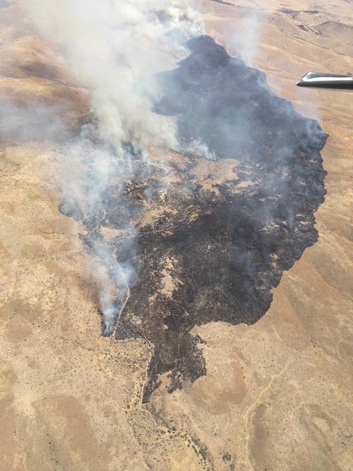
McDannald Fire, April 30, 2018
McDannald Fire, April 30, 2018. Texas Forest Service photo.

Red Flag Warnings, May 2, 2018

Posted on Categories UncategorizedTags

The National Weather Service has issued Red Flag Warnings or Fire Weather Watches for areas in Colorado, Kansas, Oklahoma, Texas, New Mexico, New York, Pennsylvania, and New Jersey.

The map was current at 8:15 a.m. MDT on Wednesday. Red Flag Warnings can change throughout the day as the National Weather Service offices around the country update and revise their forecasts.