Wildfire potential, November through February

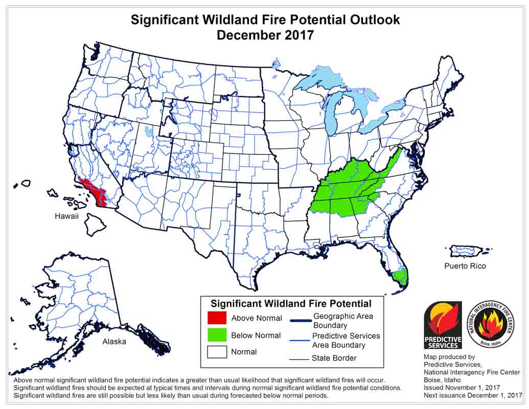
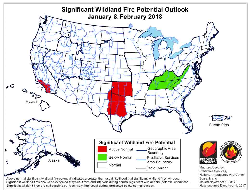
On November 1 the Predictive Services section at the National Interagency Fire Center issued their Wildland Fire Potential Outlook for November through February. The data represents the cumulative forecasts of the ten Geographic Area Predictive Services Units and the National Predictive Services Unit.

If the prediction is accurate, Southern California should see higher than normal wildfire activity well into next year.

Below are:

  • The highlights of the NIFC report;
  • NIFC’s graphical outlooks;
  • NOAA’s long range temperature and precipitation forecasts; and
  • Drought Monitor.

“Warm and dry conditions continued across California and the Southwest in October. Several easterly, multi-day wind events coupled with high heat and very low humidity values contributed to significant bursts of fire activity California mid-month. A passing front at the end of the third week of the month brought much needed moisture to the dry fuels across the northern half of the state. The southern half of the Great Basin also saw an increase in grass fire activity during the month due to the warm, dry, and occasionally breezy conditions.

“Looking elsewhere, most of the rest of the nation exited the core fire season though occasional activity was observed along the Rocky Mountain Front in Montana and Wyoming. The autumn fire season in the Southeast was much quieter than the previous year due to the passage of several wet cold fronts that brought timely and occasionally abundant moisture.

“Temperatures across the East, Southwest, and California were generally above average for the month with some locations along both the East and West Coasts reaching as much as fifteen degrees above average at points. The Pacific Northwest, Northern Rockies, northern Great Basin, and central Rockies generally experienced cooler-than-average conditions though a warming trend developed near month’s end. Alaska was generally colder and wetter than average.

“Precipitation departures from average showed significant dryness across the southwestern quarter of the nation and across much of Texas. Significantly wet conditions were observed across the Northwestern quarter of the country as several very wet systems impacted the region during the middle to latter half of the month. Another wet signal for the month was observed across the Great Lakes Region and the Ohio and Tennessee River Valleys.

“Latest forecast data suggests that California will remain the focus of periodic bursts in fire activity through November and possibly into December. Portions of the Deep South may also exhibit increased activity in between precipitation events as well. By February, the focus will shift to the southern Great Plains as the antecedent dry conditions begin to take its toll.”

wildfire potential december, 2017

january february 2018 wildfire potential Continue reading “Wildfire potential, November through February”

37 million fire extinguishers may not work — Kidde issues recall

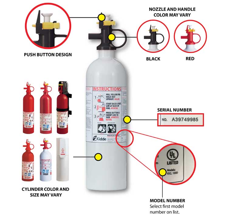
Today the Consumer Products Safety Commission announced a massive recall of 37.8 million Kidde fire extinguishers in the United States. The safety related issues are the plastic handles and nozzles that can break, become clogged, or require excessive force to discharge, and they may fail to activate during a fire emergency. In addition, the nozzle can detach with enough force to pose an impact hazard. About 2.7 million of the extinguishers were also sold in Canada.

The recall applies to some Kidde models manufactured during the last 43 years.

The CPSC points to the death of a person in 2014 who died after his car crashed and burned. Police attempted to use two of the suspect extinguishers, but both failed.

The CPSC website has a list of the models that are affected. Consumers having one of the extinguishers should immediately contact Kidde to request a free replacement and for instructions on returning the recalled unit, as it may not work properly when needed during an emergency.

Someone spending time trying to get a defective extinguisher to work would be much better off escaping from the fire.

Kidde fire extinguisher recall

2017 Pulaski Award given to Spaceport Integration Team

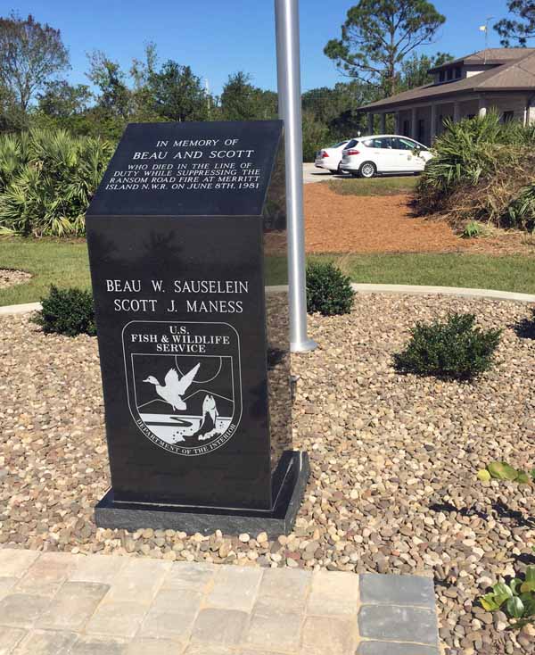
A memorial was also dedicated to two USFWS firefighters who perished on the Ransom Road Fire in June, 1981.

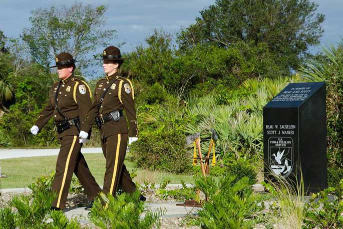
Memorial Honor Guard FWS
The FWS honor guard places two crossed Pulaski tools at the memorial, a traditional ceremony acknowledging the passing of a wildland firefighter. FWS photo.

In a dual-purpose ceremony November 1 at Merritt Island National Wildlife Refuge in Eastern Florida (map) a group of land managers received an award and a memorial was dedicated to two deceased wildland firefighters.

In 1981 two U.S. Fish and Wildlife Service (FWS) firefighters were killed on the Ransom Road Fire at the Refuge. Scott Maness and Beau Sauselein were building fireline with a tractor plow when a passing thunderstorm caused a 90-degree wind shift in the wind direction with gusts up to 45 mph. They raised the plow and tried to escape on the tractor but it became high-centered on a stump concealed by palmetto. They dismounted and fled on foot but were overtaken by the fire. The two men shared a fire shelter but both were killed.

Today the Refuge hosted an outdoor ceremony near Cape Canaveral with 140 guests, including former co-workers and family members of Mr. Maness and Mr. Sauselein. The historic tragedy triggered dramatic improvements in the FWS fire program, culminating in a professional collaboration with federal, state, and local partners to support the safe operation of the spaceport while protecting a myriad of resident wildlife species.

FWS photo.

The ceremony opened with the six-person uniformed FWS National Honor Guard presenting colors and symbolically placing firefighting tools at an inscribed granite marker in front of the Refuge headquarters. Designed and built by the Refuge’s fire crew, the new memorial is now a daily reminder to staff of how two men gave their lives, imparting lessons leading to improvements in firefighter safety.

Pulaski award
Spaceport Integration Team representatives with Pulaski Award plaques. Colonel Z. Walter Jackim, Vice Commander, 45th Space Wing, Patrick Air Force Base, Cape Canaveral Air Force Station; Michael Good, Acting Fire Management Officer, Merritt Island NWR; John Fish, Chief, Florida Forest Service; Mark Schollmeyer Chief, Brevard County Fire Rescue; and Kelvin Manning, Associate Director, Kennedy Space Center, National Aeronautics and Space Administration. FWS photo.

Following the memorial dedication, FWS Chief of Fire Management Chris Wilcox presented the National Interagency Fire Center 2017 Pulaski Award to the Spaceport Integration Team of FWS, Kennedy Space Center, Cape Canaveral Air Force Station (45th Space Wing), Florida Forest Service, and Brevard County Fire Rescue. The group award is given by NIFC fire chiefs including the U.S. Forest Service, National Park Service, National Association of State Foresters, and other fire programs.

About 35 attendees are also participating this week in a field study of the Ransom Road Fire. Modeled after a military leadership “staff ride,” the day-long exercise focuses on the progression of events and decision making that led to the loss of life. As the first formal staff ride at the Refuge, fire leaders hope to repeat the Ransom Road Fire exercise for more fire managers in the future.

ceremonial Pulaski tool
A ceremonial Pulaski tool. FWS photo.

Sky lantern incident — 15 people injured and 4 houses destroyed

A sky lantern caused burn injuries to 15 people when one of the dangerous devices landed on a shop in the Indian state of West Bengal. The fire spread to four kutcha houses, gutting them, and injured 13 adults and two children who were all admitted to Tamluk hospital.

Police said six people, including the two children, were in serious condition.

Sky lanterns, also known as Chinese lanterns, are plastic or paper bags lofted by the heat created by burning fuel at the bottom. After they are launched the perpetrator has no control and the dangerous devices are carried wherever the wind blows. Too often they get caught on trees, roofscell phone towers, or land on the ground when the flames are still active and start damaging fires. They are banned in most U.S. states and many countries, including Brazil.

Arizona Supreme Court refuses to hear case about burned structures in Yarnell Hill Fire

Property owners sought compensation from the state for houses that were destroyed.

Yarnell Hill Fire approaching Yarnell, Arizona, June 30, 2013. Photo by Joy Collura.

The Arizona Supreme Court has refused to hear a case in which property owners sought to obtain compensation from the state for the structures that were destroyed in the Yarnell Hill Fire in June, 2013. A lower court had already ruled that the owners had no legal recourse.

According to media reports, Attorney David Abney had hoped to argue that since Arizona state employees told the residents that they would protect the structures, the government was then obligated and had a duty to perform fire suppression activities in a nonnegligent manner.

“If the people of Yarnell had understood the state was going to do this incredibly incompetently, and the state was going to do a late and improper evacuation notice, they could have taken some measures to protect themselves,” Mr. Abney explained.

“They could have gotten their personal possession out, their pets and livestock out,” he continued. “They could have removed propane tanks that blew up in the fire, they could have removed their excess vehicles.”

Thanks and a tip of the hat go out to Joy.
Typos or errors, report them HERE.

Simulation shows winds near origins of Oct. 8 fires in Northern California may have been 75-90 mph

“Hurricane force” winds, according to the National Weather Service, are sustained winds or frequent gusts of 74 mph.

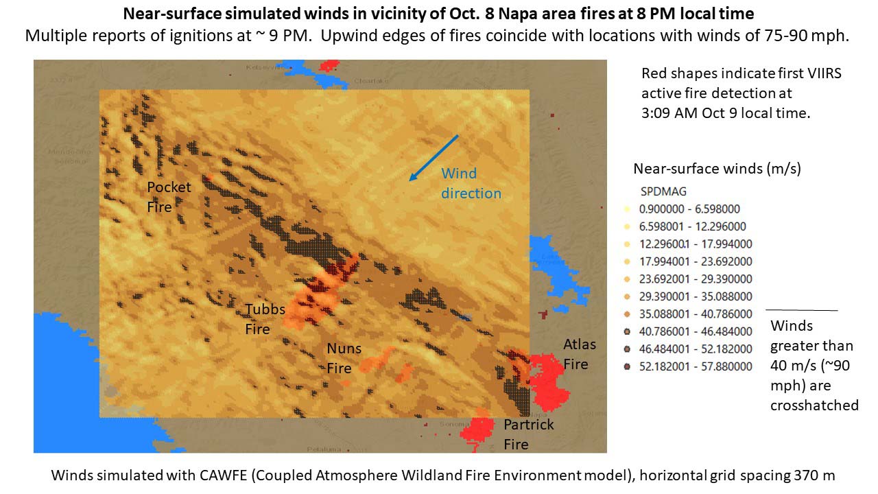
Above: Fine-scale weather model simulation (horizontal grid spacing of 370 meters) analyzing the surface wind when the Northern California fires started, 8 p.m. local time October 8, 2017. The darkest brown areas (with cross-hatching) indicate wind speeds greater than 40 m/s (~90 mph). The red shapes indicate heat from active fires first detected by a satellite (VIIRS) at 3:09 a.m. local time October 9, 2017.  Simulation by Dr. Janice Coen, a Project Scientist at the National Center for Atmospheric Research in Boulder, Colorado. Simulated with the Coupled Atmosphere Wildland Fire Environment model.

(Originally published at 10:40 a.m. MDT October 30, 2017.)

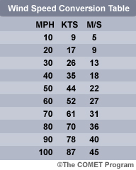
More research into the weather conditions when the devastating October 8 wildfires started in Northern California indicates that hurricane force wind was one of the factors responsiblewind speed conversion table for the extremely rapid spread of the fires that killed at least 43 people and destroyed more than 8,900 structures.

Dr. Janice Coen, a Project Scientist at the National Center for Atmospheric Research in Boulder, Colorado ran fine-scale weather model simulations (horizontal grid spacing of 370 meters) analyzing the wind during the time the fires started. Her research (see chart above) showed significantly higher surface wind speeds than previously thought — 75 to 90 mph just upwind of the major fires.

CAL FIRE has not released the causes of the October 8 conflagrations, but at about the same time firefighters were first responding to numerous fires, they also received multiple calls about fallen power lines and electrical transformers exploding.

California law dictates that power lines are supposed to be able to withstand 56 mph.

In an email Dr. Coen told us more about the October 8 wind simulation and her research related to fire weather:


“These early simulations suggest that within a wide area of strong winds, these small, local bands of extreme winds occurred where winds were perpendicular to the local ridge. And, that the location of the peaks and their peak speeds evolved throughout the event as the wind direction changed, in part due to the high pressure over the Great Basin moving along.

“I don’t have a lot of confidence that we’d be able to find evidence to prove or disprove if/when a particular simulated wind speed maximum occurred.  And, although there is a lot of theoretical and laboratory work on stably stratified flow over objects, this three-dimensional terrain is too complicated to apply much of that.

“We’ve seen a sequence of devastatingly destructive fire events each driven by strong wind events – 2007 fires in southern California driven by Santa Anas, surprising destruction from a mountain downslope wind-driven fire in Gatlinburg, TN, and now this – yet fine-scale investigations of the mechanisms producing the peak winds and how they are distributed, particularly in relation to potential ignition sources, don’t really exist. And, though our forecast models may indicate strong gusty winds are possible, explicitly predicting how extreme the winds might be and where the most dangerous spots are with the detail shown here is beyond their capabilities.

“I hope to learn and share more about the mechanics of these events by visualizing these simulations, so we can see inside these events, prepare and anticipate, contribute to firefighter awareness and safety (as Diablo winds in general are a regional fire issue), and perhaps help potential ignition sources such as utilities manage the risk.”

wind simulation october 8 fires northern california
Fine-scale weather model simulation (horizontal grid spacing of 370 meters) analyzing the weather during the time the Northern California fires started, 8 p.m. local time October 8, 2017. The darkest brown areas indicate wind speeds greater than 40 m/s (~90 mph). Simulation by Dr. Janice Coen, a Project Scientist at the National Center for Atmospheric Research in Boulder, Colorado.