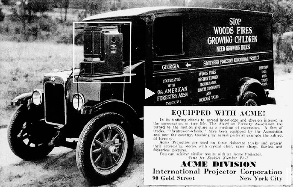
A truck with a movie projector visited rural communities to teach people about the evils of wildfire. PBS.
A PBS program, “The future of Fire,” takes us from the 1920s when trucks visited rural communities in the Southeast and used a projector to show a movie on the side of barns about the evils of fire, to today when modeling tools help fire managers make better decisions about using and managing fire.
"Her vision is that she'd be able to sit on her front porch and just watch the fire go by and be completely unconcerned because the conditions around her home were such that she would be confident that she had done her work and her neighbors had done their work and it was safe to actually have fire play an active role in restoring the landscape. And that we don't look at all smoke as bad, that we be really working toward seeing smoke and have that be a positive experience, that it's like, oh, the forest is under renewal right now."

Anne Bradley, Forest Program Director, The Nature Conservancy, paraphrasing someone she knows who lives in the forest.
McBride Fire in southern New Mexico. From Melissa Gibbs KRQE video April 12, 2022.
When the US Forest Service Deputy Chief of State and Private Forestry testified before members of Congress on April 5 that a firefighter hiring event “went very well”, the event had not started yet.
Jaelith Hall-Rivera, US Forest Service Deputy Chief of State and Private Forestry, testified April 5 before a House Committee.
“We just completed an additional fire hire event in California at the end of March and those numbers are still coming in,” Ms. Jaelith Hall-Rivera said. “I do think we are on pace. By all accounts that hiring event went very well. Importantly what we are seeing is a very high acceptance rate in our permanent and seasonal permanent firefighting positions, which is what we want.”
In an article published today, Brianna Sacks of BuzzFeed News reported that the hiring event actually began April 11, six days after Ms. Hall-Rivera’s testimony, and is scheduled to go through April 29.
Ms. Hall-Rivera’s statement was in response to a series of questions from Rep. Katie Porter from California. You can watch this exchange in the video of the hearing we posted April 5 as part of a summary of the testimony before the House Subcommittee on National Parks, Forests, and Public Lands. Rep. Porter’s excellent questions begin at 138:35.
Below are excerpts from the BuzzFeed article:
A Forest Service spokesperson told BuzzFeed News that the deputy chief made an “error” because she “didn’t have all the information in front of her.”
“There are several hiring events throughout the year, and I think she was thinking of a different one in a different region,” the spokesperson said, but he did not provide specifics as to which one that might have been. The spokesperson also did not have hiring numbers that might back up Hall-Rivera’s assurances.
Interviews with firefighters in Colorado, New Mexico, Oregon, Washington, and California, as well as internal communications, hiring data, org charts, and surveys from the nonprofit Grassroots Wildland Firefighters, also tell a different story.
For example, in a Feb. 15 meeting hosted and attended by senior Washington officials, fire directors from across the US shared their issues with hiring, according to meeting notes obtained by BuzzFeed News. In New Mexico, where fires are currently raging, leaders said multiple hotshot crews would not be fully staffed. In the Pacific Northwest and Alaska, leaders said there is a “lack of candidates” and they are “unable to staff seven days in many places.” There is a “continued decline of folks to do the work.”
As California, Oregon, Utah, Washington, and Colorado gear up for fire season, interviews with three Forest Service employees familiar with hiring say the situation is grim. Without a serious staffing push, engines will sit idle, helicopters won’t be able to fly daily, crews won’t be able to start the season on time, and those who have worked multiple seasons in the field aren’t sure how much more they can stretch themselves without falling apart, they said. The Thomson Reuters Foundation, which also recently investigated systemic staffing issues, highlighted retention issues due to pay and housing.
In parts of Montana and Idaho, which had 700 seasonal workers last year, only 460 have returned for this fire season, a source familiar with the numbers said. And after last year’s Fire Hire, California had filled only 56 of 781 open positions, according to data obtained by BuzzFeed News. As of April 8, two days before this year’s hiring push, California had more than 1,560 vacancies, according to a review of the state’s openings.
More and more articles like this are being published documenting the hiring and retention difficulties that face the US Forest Service and Bureau of Land Management.
From Thomson Reuter Foundation News, April 25, 2022:
An engine captain involved in temporary hiring in northern California indicated that almost all Forest Service forests in the area expected to have less than 65% of full staffing for firefighters this year, some below 50%, according to a federal firefighting source who spoke on condition of anonymity.
“Fundamentally, people don’t want to take jobs because they can’t find a place to stay,” [Kelly] Martin [of the Grassroots Wildland Firefighters] said.
One female wildland firefighter – who lives out of her camper in California to save on rent – said proposals to increase base pay would not make up for the lack of an attractive career path for more experienced firefighters.
“Just raising the wages for those coming into fire is not going to be enough to keep people around,” she said, asking not to be named.
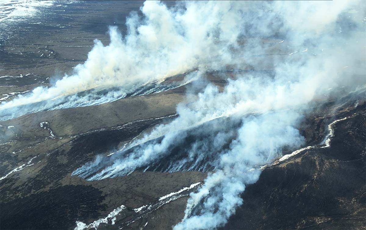
Less winter snow than usual, and dry, windy weather contributed to the growth
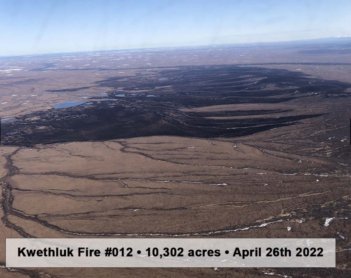
Kwethluk Fire, southwest Alaska, April 21, 2022. Alaska DNR DOF.
At Wildfire Today we don’t often write about fires in Alaska. In some years they have a great many fires but it varies enormously from year to year. Since 2010 the number of acres burned annually has ranged from a low of 181,169 in 2020 to a high of 5,111,404 in 2015. Many of the blazes are not suppressed and they don’t often affect a significant amount of private property or structures.
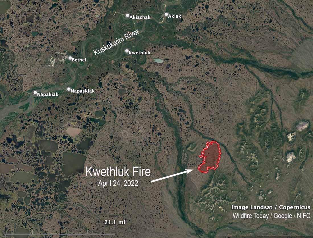
But it stirred my interest when I saw a headline about a current fire that is supposedly the largest April wildfire in Alaska in a quarter century. It is the 10,302-acre Kwethluk Fire in southwest Alaska 30 miles southeast of Bethel. An April 26 article in the Anchorage Daily News reported that climate scientist Rich Thoman said, “It’s not like dry Aprils are unusual; this is the dry season. But typically you would expect there would still be enough snow around that, even if a fire got going, that it would, within yards, run into snow.”
The area had less snow than usual this winter and it melted and exposed the tundra early. Wind, sun, and less precipitation than usual have dried out the fuel.
Map, Kwethluk Fire, southwest Alaska, April 24, 2022.
The Alaska Division of Forestry reported April 26 that the spread of the Kwethluk Fire had stopped.
Below are excerpts from an April 26 update by the DOF about the fire:
“Burning in tundra, grasses and brush since Saturday April 16th, the wind driven wildfire has been finding sun dried fuels in the Yukon Delta National Wildlife Refuge. DOF’s mapping specialist Matt Snyder flew a mapping and reconnaissance of the fire today noting in his field report this afternoon: “the fire is showing no smoke or activity. An infrared (IR) scan showed no heat. The fire will remain in monitor status so that further aerial observations can be made.”
“Originally scheduled for yesterday but delayed due to heavy cloud cover, today’s flight under clear sky shows the lack of smoke production from what was a 10% active perimeter when last observed on Friday’s flight. The natural barriers halting further spread include mountains, winter snowpack, icy creeks and rivers. Precipitation and increased humidities have also slowed fire spread. Persistently able to throw spotfires over frozen creeks and drainages for most of the last 10 days, the Kwethluk Fire remains two miles from the nearest native allotment.
Kwethluk Fire, southwest Alaska, April 26, 2022. Alaska DNR DOF.
“Values at risk include native allotments one mile to the northeast, 2.3 miles to the southeast, 3.3 miles to the west, and the Kwethluk Fish Weir approximately 5 miles to the west southwest. An additional surveillance flight will take place this week as needed and fire managers will continue to monitor both satellite heat sensors, FAA Weather Aviation cameras, and good Samaritan reports from Kwethluk, Bethel and Napakiak.
“It is common to have wildfires at this time of year in Alaska. As our daylight lengthens, the snowpack recedes and exposes the tundra grasses, mosses and shrubs to the drying effects of the wind and the sun. These conditions, coupled with sparse precipitation, work to dry out the tundra plants and make them available as fuel for combustion. Western Alaskan wildfires burning at this time of year tend to be wind driven and fast moving but also short-lived. These fires cannot burn deeply below the surface due to the shallow frost layer and tend to readily extinguish themselves as they encounter drainages and sloughs, differing vegetation, existing areas of snow, or changes in weather.”
Below is a flyover of the Kwethluk Fire narrated by DOF Specialist Matt Snyder recorded April 18, 2022. At the time it was 4,048 acres.
Thanks and a tip of the hat go out to Gerald.
More information about the fire from the Alaska Division of Forestry.
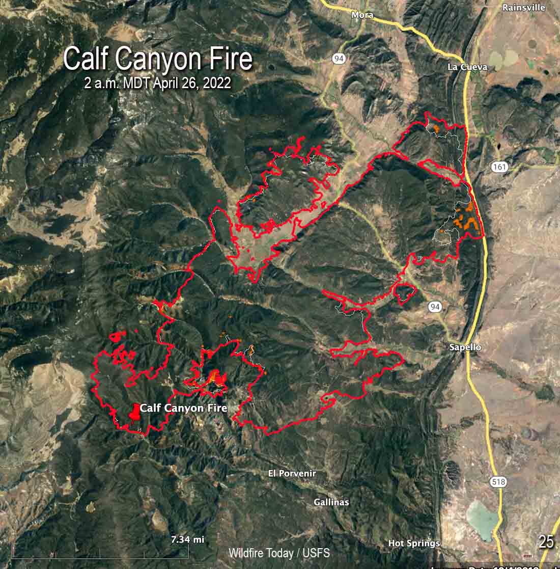
Map of the Calf Canyon Fire after it merged with the Hermits Peak Fire. The red line was the perimeter at 2 a.m. MDT April 26, 2022. The white line was the perimeter about 24 hours before.
With more favorable weather conditions and less active fire behavior on the Calf Canyon and Hermits Peak Fires, on Monday firefighters were able to engage in operations in areas that had previously been difficult to reach safely.
There was incremental growth on Monday. The fire was mapped by an aircraft at 2 a.m. MDT Tuesday and found to have burned 60,173 acres. That is the combined size of the two fires that merged.
Firefighters were able to engage aggressively across the fire area yesterday, capitalizing on the favorable weather conditions.
To see all articles on Wildfire Today about the Calf Canyon and Hermits Peak Fires, including the most recent, click HERE.
“Fire managers are determining where to focus resources based on weather, terrain, predicted fire behavior, and values at risk,” according to a statement issued by the Incident Management Team.”These decisions are based on the highest probability of success and flexible options in the event of sudden changes in weather or fire behavior.”
Law enforcement agencies are assessing impacts the fire had on structures and will be notifying property owners once confirmed.
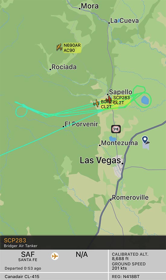
Map shwing two CL-415 air tankers on the Calf Canyon Fire, April 26, 2022. The track of one, Tanker 283, is displayed. FlightRadar24.
Beginning Monday and continuing on Tuesday, four water-scooping air tankers have been obtaining water from Lake Isabel and dropping it on the fire. To date, the scoopers along with other aircraft have delivered over 265,000 gallons. The lake is 8 miles east of the east side of the fire, which would be about a 5 minute one-way trip carrying up to 1,600 gallons of water. The map above shows the track of one of two CL-415 air tankers working the fire at 10:52 a.m. on Tuesday. An icon for a second CL-415 is also seen, but without its track — they often work in pairs.
Hermits Peak Fire by @jennalunaphoto
The wind will be out of the southwest at 20 mph Tuesday increasing to 24 with gusts to 32 on Wednesday. The forecast calls for the relative humidity to be in the high teens Tuesday, and on Wednesday in the 20s with a chance of thunderstorms and a small amount of rain.
The fire is eight miles south of Prescott, Arizona
4:38 p.m. MDT April 25, 2022
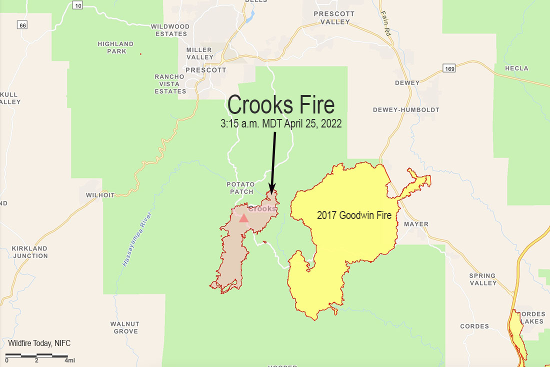
Crooks Fire map, 3:15 a.m. MDT April 25, 2022
A wind from the north on April 25 pushed the Crooks Fire three miles to the south in Ash Creek, increasing the size to 5,893 acres according to a fixed wing flight very early Monday morning. The northern edge of the blaze is 8 miles south of Prescott, Arizona. The east side is about a mile west of the Goodwin Fire that burned about 28,000 acres in 2017 (see map above).
The north wind provided good conditions Monday to complete firing operations on the north side to prevent spread to the northwest into Lookout Mountain and Dosoris Canyon. Throughout the day and into the night, firefighters extended the fireline south of Lookout Mountain toward Ash Creek and from Moscow Peak west to Senator Highway.
Crooks Fire as seen from Mt. Union Lookout, April 23, 2022. IMT photo.
Fire managers are planning contingency lines south and west of the fire in case winds push the fire in those directions.
Resources assigned include 19 hand crews, 38 fire engines, and 12 helicopters for a total of 675 personnel.
Weather
At 3:30 p.m. MST Monday at the Prescott Airport (elevation 5,043) the relative humidity was 9 percent, the temperature was 72, and the wind was east-southeast at 3 mph. The elevation at the fire ranges from 5,000 to 7,000 feet.
The weather on Tuesday and Wednesday could produce an increase in the rate of spread of the fire. The forecast for the area on Tuesday is for 20 mph winds out of the south gusting around 30, with relative humidity in the teens and the temperature in the 60s. On Wednesday the conditions will be similar but with winds a little stronger, 23 mph gusting to 26 mph. Thursday will be about the same as Wednesday.
Satellite photo showing smoke from the Crooks Fire at 3:01 p.m. MDT April 25, 2022.
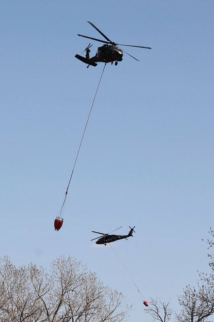
Blackhawk helicopters from the Nebraska National Guard drop water on the Road 702 Fire west of Cambridge. Incident Management Team photo.
Firefighters made good progress Monday on the Road 702 Fire in southwest Nebraska.
Most of the fire impacted grass and crop lands, but there are woody draws which have heavier fuels, especially on Beaver Creek along Highway 89 and near the Republican River south of US 34. Those areas are receiving more attention from firefighters as they are mopping up. Incident Commander Rob Powell said there will be smoke in those draws for a while.
The most recent map produced at 4 p.m. MDT April 25 shows an increase of about 300 acres to bring the total up to 41,448 acres, due to a four mile long finger of fire north of US 34 northeast of Bartley that was not detected during an earlier mapping flight. Fire crews have contained all of the fire north of the highway, including the additional acreage.
The fire started in Kansas on Friday April 22 during a wind event which pushed it north quickly into Nebraska where it continued running. The fire was 27 miles long when firefighters were able to stop it two miles southwest of the Medicine Creek Reservoir.
Video captures a helicopter from the Nebraska Army National Guard dropping water on The #Road702Fire near Cambridge, Nebraska on April 24. The blaze has spread to an estimated 50,000 acres. #NEwx
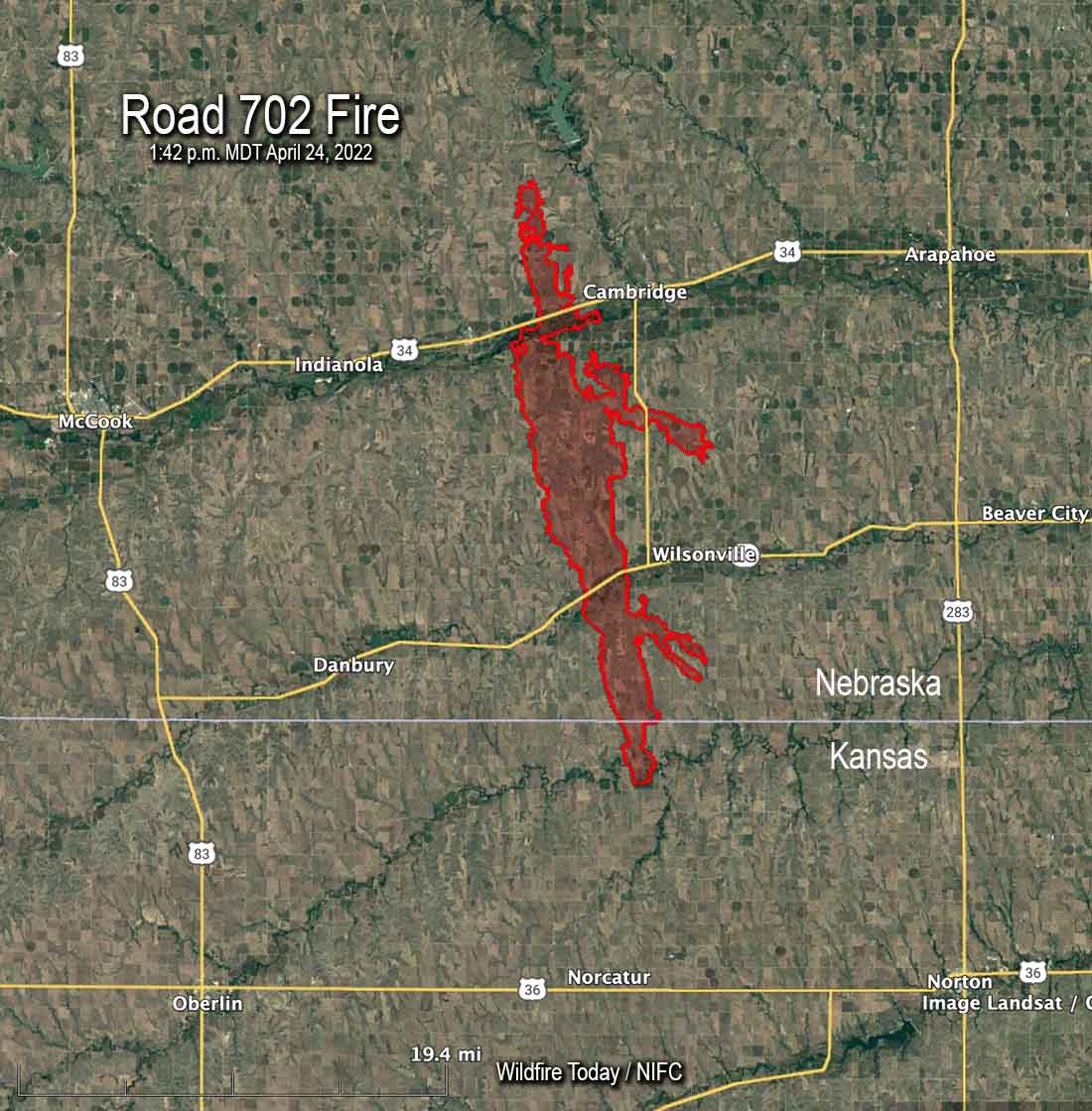
Map of the Road 702 Fire at 1:42 p.m. MDT April 24, 2022.
A retired fire chief died in a Nebraska fire that has burned 41,155 acres in the southwest part of the state. The Road 702 Fire is west of the towns of Cambridge and Wilsonville and has crossed both US 34 and State highway 89. About 1,500 acres of the blaze is in Kansas.
Alyssa Sanders, with the Nebraska Emergency Management Agency, said 66-year-old John P. Trumble, of Arapahoe, was overcome by smoke and fire after his vehicle left the road Friday April 22 during conditions of poor visibility caused by smoke and dust. His body was found early Saturday. He was assisting firefighters by serving as a spotter in Red Willow County.
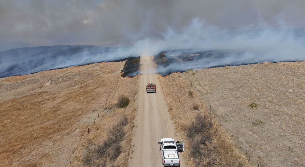
Road 702 Fire. Nebraska State Patrol drone photo.
Nebraska National Guard has mobilized three helicopters and several support trucks to help battle the fire.
A Type 1 Incident Management Team from the Rocky Mountain Geographic Area led by Incident Commander Dan Dallas assumed command April 24.
Stephanie Shively with the Incident Management Team said Monday morning that the resources on the fire include 9 engines, one 20-person crew, and the 3 National Guard helicopters for a total of about 100 personnel. They have outstanding orders for dozers and another hand crew.
Ms. Shively said the size of the fire has not changed since it was mapped Sunday.
We send our sincere condolences to the family, friends, and co-workers of Chief Trumble.
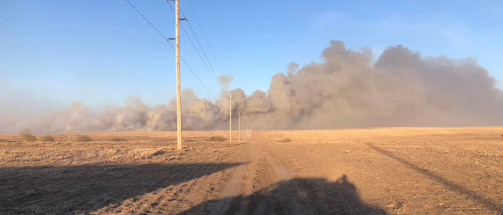
Road 702 Fire. Posted April 24, 2022 by Loomis Volunteer Fire & Rescue.Nebraska Army and Air National Guard firefighters work the edges of a burned area near Hayes Center, Neb., April 24, 2022, to extinguish hot spots and prevent reignition. Photos courtesy of Capt. Joshua Miller.