Hermits Peak Fire spreads further east prompting more evacuations

Updated at 8:25 a.m. MDT April 14, 2022

Map Hermits Peak Fire
3-D Map of the Hermits Peak Fire, looking west-southwest. The red line represents the perimeter at 7:30 p.m. April 13, 2022. The white line was the perimeter at 3 a.m. MDT April 13, 2022.

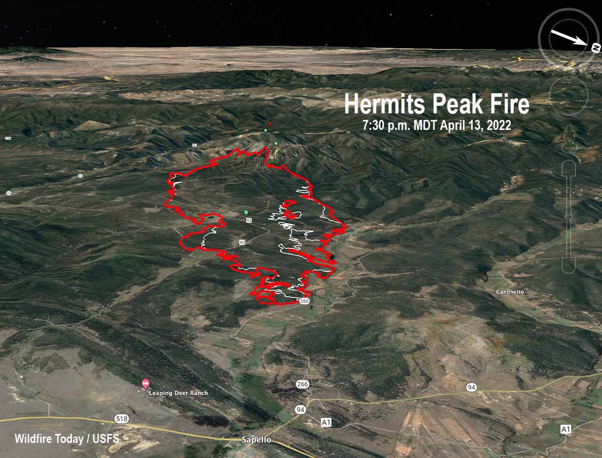
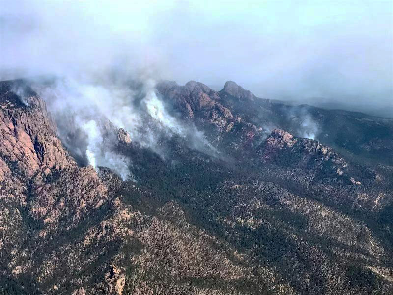
Operations Section Chief Shilow Norton said that decreasing winds on Wednesday allowed firefighters to make significant progress on the Hermits Peak Fire 12 miles northwest of Las Vegas, New Mexico. They used helicopters to drop water on the southeast side of the fire to support dozers as they constructed fire line. Crews nearly completed that line and hand crews worked through the night on steep portions of the east end that were inaccessible to dozers.

On the northeast side, south of the 266 Road and the Sapello River, firefighters were able to put in fire line in areas where the fire had moved out of the timber and into grass. Dozers also put in direct fireline south and southwest of San Ignacio.

Click to see all articles on Wildfire Today, including the most recent, about the Calf Canyon, Hermits Peak, and Cooks Peak fires.

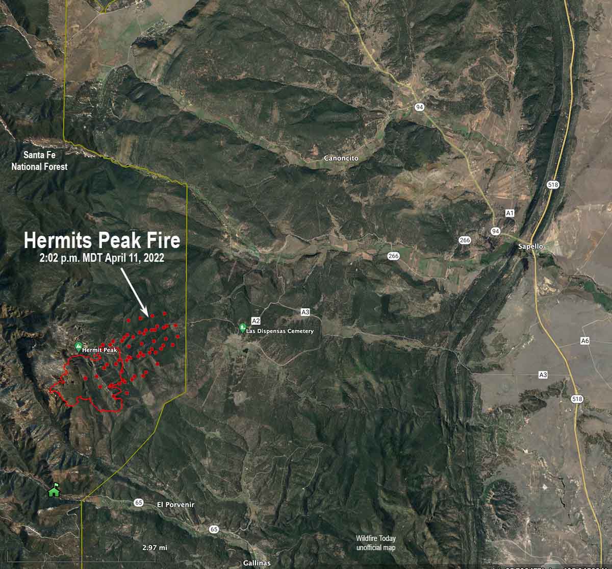
Mapping Wednesday evening determined that the fire had burned about 7,000 acres.

Sheriff Chris Lopez said initial assessments have found five outbuildings that were destroyed but have not seen any homes that burned.

A Red Flag Warning is in effect Thursday for southwest winds 20 to 30 mph gusting to 40 with relative humidity of 4 to 10 percent.


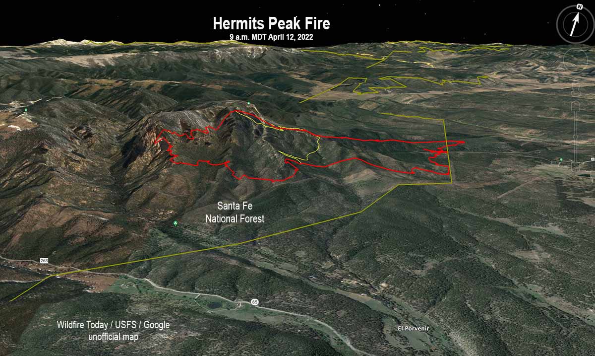
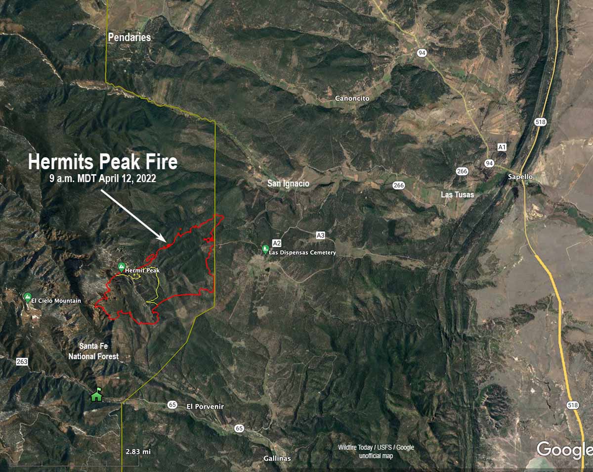
12:03 p.m. MDT April 13, 2022

3-D Map Hermits Peak Fire 3 a.m. April 13, 2022
3-D Map Hermits Peak Fire. Looking west-southwest at 3 a.m. April 13, 2022.

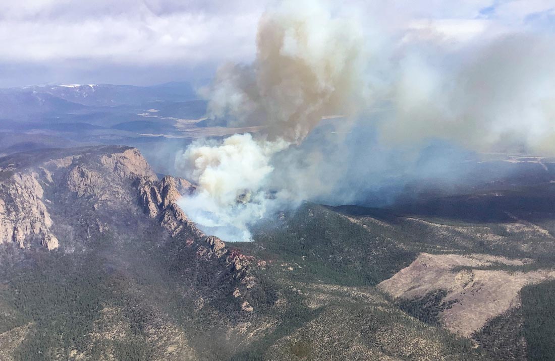
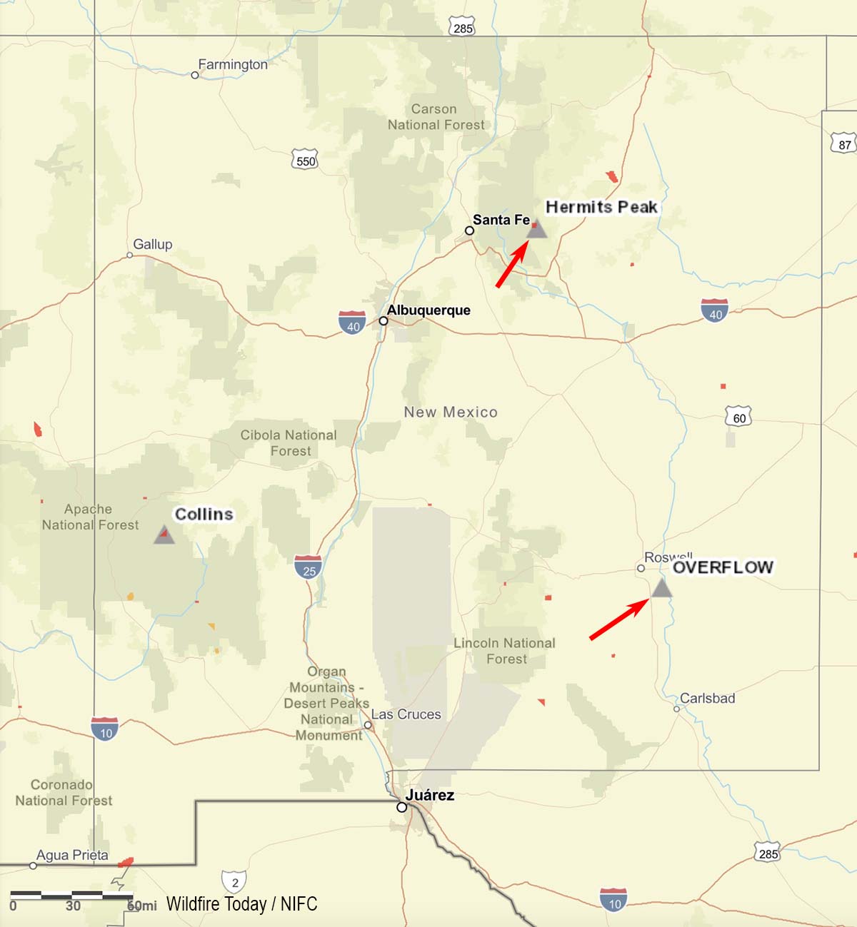
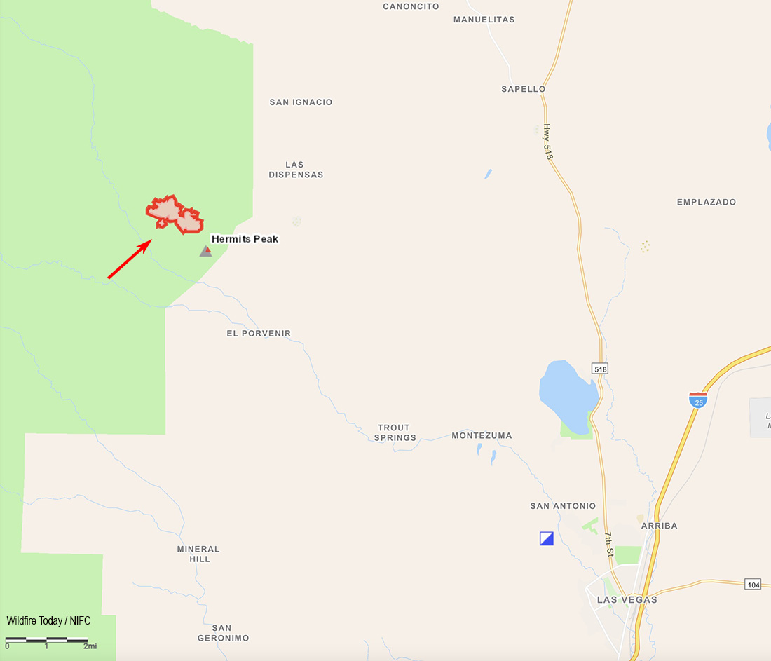
The Hermits Peak Fire spread nearly four miles to the east on Tuesday, growing to 6,276 acres by Tuesday night according to the Santa Fe National Forest. (Reports from other government sources put it at 7,900 acres.) The fire is 12 miles northeast of Las Vegas, New Mexico. The east side of the fire has moved into flatter terrain, providing better access for firefighters. But until the wind speeds decrease, they will primarily be following the fire, picking up a few sections of the flanks as the head continues to move.

In a Wednesday morning briefing  Operations Section Chief Shilow Norton said winds with sustained speeds of 48 mph gusting to 60 caused spot fires east of the fire Monday night. The fire continued to spread to the east-northeast on Tuesday and moved through the community of Las Dispensas. The 20 homes there had been prepped by firefighters in the last few days to reduce the chance of them burning. Mr. Norton said firefighters had to leave when the fire came through on Tuesday and later came back, but to his knowledge all of the homes were saved. The fire also impacted San Ignacio and Las Tusas. Firefighters are having some success, he said, in holding the northeast side of the fire in several places in the drainage along the Sapello River.

To see all articles about the Hermits Peak Fire on Wildfire Today, including the most recent, click HERE.

When the wind dies down, said Mr. Norton, previously completed fuel treatments east of the fire southwest of Sapello could be helpful in slowing the spread, allowing firefighters to take direct action. But with 48 mph winds, virtually nothing will stop the head of the fire. The wind has made it impossible for air tankers and helicopters to be effective.

Map Hermits Peak Fire 3 a.m. MDT April 13, 2022
Map, Hermits Peak Fire. The red line was the perimeter at 3 a.m. MDT April 13, 2022. The white line was the perimeter at about 9 a.m. April 12, 2022.

The extreme fire activity prompted additional evacuations affecting the Canoncito area in the Manuelitas Creek drainage, locations near Manuelitas, and north of Gallinas.

Evacuations

The San Miguel County Sheriff’s Office has issued evacuation orders using the Ready, Set, Go! system. The following areas are in Go status (i.e., residents should be evacuating): Las Dispensas, Pendaries Village, San Ignacio, Las Tusas, Lone Pine Mesa, Canoncito, La Canada, Manuelitas, Lower Canyon Road in Gallinas Canyon and La Tewa, Chavez, County A3, Southwest Sapello, and Southern Tierra Monte-Canyon. The following areas are in Set status (i.e., residents should be preparing for a potential evacuation): Upper Rociada, Rociada, Pendaries Valley East, Penasco Blanco, South Carmen, Northern Tierra Monte-Canyon, Big Pine, Canovas Canyon, El Porvenir, Gallinas, and Trout Springs. An evacuation shelter is available at the Old Memorial Middle School gym located at the corner of Legion and Old National in Las Vegas, NM.

Weather

Red Flag Warnings are again in place for strong winds and low humidity. After a hard freeze Wednesday morning, it will be sunny and cool, with high temperatures far below normal.

McBride Fire starts near Ruidoso, NM as winds were gusting over 70 mph

Burned thousands of acres in the first few hours

Updated at 9:02 a.m. MDT April 13, 2022

Map, McBride Fire April 12, 2022
Map, McBride Fire April 12, 2022. (the time is uncertain)

The Incident Management team’s latest update on the McBride Fire was Tuesday night at 9 p.m. At that time the size was listed at 4,138 acres. Approximately 150 structures have burned.

The blaze spread very rapidly after it started Wednesday afternoon. The fire behavior was described by firefighters as extreme, with crowning and spotting as it burned to the northwest through timber and grass.

To see all articles on Wildfire Today about the McBride Fire, including the most recent, click HERE.

Mandatory evacuations are in place for the area around Moon Mountain, McBride/Snowcap/Timberline, Eagle Creek, Homestead Acres, Rancho Ruidoso Valley Estates, Deer Valley, Deer Park, and Alto east of Flute Player. The Ruidoso Convention Center is accepting evacuees. More evacuations are possible. The Lincoln County Fairgrounds, Roswell Animal Shelter, and Otero Fairgrounds are open for those who need to evacuate with livestock.

3-D Map, McBride Fire, April 12, 2022
3-D Map, McBride Fire, April 12, 2022. Looking north.

The area is under a Red Flag Warning again on Wednesday. The spot weather forecast for the McBride Fire issued at 1:40 a.m. on Wednesday, said, “The ongoing light precipitation will end in the next 3 hours with no accumulation expected.” On Wednesday it will be sunny. The winds will be out of the west at 16 mph with gusts to around 31 mph, with a minimum humidity of 6 percent. Wednesday night will see no humidity recovery with a maximum of 16 percent and 10 to 14 mph winds gusting to 26 out of the southwest and west. Thursday should bring west winds of 7 to 14 mph with 7 percent relative humidity.

A Type 1 Incident Management Team, Southwest Team #2, is mobilizing.


Updated at 8:15 p.m. MDT April 12, 2022

The Village of Ruidoso released an update on the McBride Fire at 7 p.m. Tuesday:

An air attack update has decreased the estimated acreage to 3,000. At this time 150 homes and structures have been lost. This is an active fire and is at 0% contained.

A mandatory evacuation notice is in order for Moon Mountain, Gavilan Canyon, Hull Road and Paradise Canyon. If you live in those areas please evacuate to the Ruidoso Convention Center. Mandatory evacuations are already in place for Eagle Creek, Homestead Acres, Rancho Ruidoso Valley Estates, Old Fort Stanton Road, and Airport Road. More evacuations are possible.

The Ruidoso Convention Center is open and the Red Cross is on site to assist those who have evacuated. The Lincoln County Fairgrounds are currently full but the Roswell Animal Shelter and Otero Fairgrounds are open for those who need to evacuate with livestock.

Crews were able to knock back the fire near the Ruidoso Middle School and evacuate 1,700+ students in 1.5 hours from Ruidoso High School, Ruidoso Middle School and Elementary Schools to the Ruidoso Convention Center. Ruidoso Municipal Schools have cancelled school for Wednesday, April 13, 2022.


6:53 p.m. MDT April 12, 2022

map Satellite image smoke McBride Fire at 5:11 p.m. MDT April 12, 2022 New Mexico
Satellite map showing smoke from the McBride Fire at 5:11 p.m. MDT April 12, 2022. NOAA.

After the McBride Fire started near McBride Drive in Ruidoso, New Mexico at approximately 2:30 p.m. April 12 it spread very rapidly pushed by winds recorded at the nearby Smokey Bear weather station at 40 mph sustained, gusting at one point to 80 mph. The winds all day in Ruidoso have been out of the southwest and the relative humidity in the afternoon dropped to 19 percent.

There are reports of multiple structures having been destroyed.

At 5 p.m. the Lincoln National Forest said on their Twitter account that it had spread to 15,000 acres and “Ruidoso residents N of Ruidoso High School need to evacuate immediately.” Specifically, areas being evacuated include Gavilan Canyon Road, Homestead Loop, Eagle Creek, Blue Lake Drive, Mira Monte Road, and east of Fort Stanton Rd. The Ruidoso Convention Center is accepting evacuees. (Later that 15,000-acre figure was reduced to 3,000 acres.)

map firefighting aircraft orbits over the McBride Fire in New Mexico
A firefighting aircraft orbits over the McBride Fire in New Mexico at 6:22 p.m. MDT April 12, 2022. ADSB Exchange map.

The fire has been spreading to the northeast toward the Sierra Blanca Regional Airport.

The local power company, PNM, shut off the electricity to 18,400 customers because the fire was moving toward a transmission line.

Within a few hours after the fire started a Type 1 Incident Management Team used for the most complex emergency incidents was ordered. It is very rare for this type of team to be requested a few hours after a fire is first reported.

With 40 mph winds gusting to more than 70, helicopters and fixed wing firefighting aircraft can’t be used safely or effectively. A small twin engine aircraft has been orbiting the fire at 17,000 feet providing intelligence and looking for opportunities to engage the fire.

McBride Fire
McBride Fire. From Melissa Gibbs KRQE video April 12, 2022.

Another fire that started on Tuesday, the Nogal Canyon Fire, is also burning on the Lincoln National Forest 12 miles northwest of Ruidoso, southwest of Nogal. Judging from heat detected by satellites it is spreading rapidly. The Forest Service said at about 4 p.m. Tuesday that all of Nogal Canyon was under an evacuation order.

Thanks and a tip of the hat go out to Tom.

PG&E reaches settlements with 6 counties for Kincade and Dixie Fires

Will pay $55 million and avoids criminal charges

Kincade Fire map, final, November 9, 2019
Kincade Fire map, final, November 9, 2019.

Pacific Gas and Electric reached an agreement Monday with six Northern California Counties to avoid criminal charges for the company’s role in igniting two very large destructive wildfires, the 2021 Dixie Fire and the 2019 Kincade Fire. The settlement means the district attorneys in the six counties will not pursue criminal charges against the company, or if they have already been filed, will be dismissed.

The Dixie Fire burned on the Plumas National Forest, Lassen National Forest, Lassen Volcanic National Park, and across five counties: Butte, Lassen, Plumas, Shasta and Tehama. The Kincade Fire was in Sonoma County.

The agreements with the counties does not prevent the US Attorney from filing criminal charges for the Dixie Fire. Nor does it prevent civil litigation from property owners. The Sacramento Bee reported that PG&E said it expects liabilities from the Kincade Fire to reach $800 million and the Dixie Fire to be $1.15 billion.

The Dixie and Kincade Fires, caused by PG&E power lines, burned 963,000 and 77,758 acres respectively.

In the settlement PG&E agreed to pay $55 million over a five year period. About $35 million will go to local organizations, volunteer fire departments, local schools, Rotary Clubs, Chambers of Commerce, fire safe councils, and other non-profits. The company will pay a $7.5 million civil penalty to Sonoma County related to the Kincade Fire and a $1 million civil penalty to each of the five North Valley counties related to the Dixie Fire. PG&E said they will not seek recovery of these costs from customers.

Details of some of the payments, according to PG&E, include:

Wildfire Safety

  • Local Safety Workforce: Adding 80-100 new PG&E jobs based in Sonoma County, as well as 80-100 more positions collectively across Butte, Lassen, Plumas, Shasta and Tehama counties. These new positions will increase PG&E’s local expertise and presence focused on completing critical safety work in these communities.
  • Local Inspection and Work Commitments: Executing specific safety work and inspections in the six counties including commitments to carry out vegetation management and equipment inspections, which will be reviewed and verified by the independent monitor.

Local Community College Partnerships

  • Fire Technology Training Program: Committing to work collaboratively with Santa Rosa Junior College (SRJC) on efforts to expand and enhance the College’s Fire Technology Program of the Public Safety Training Center, including providing funding and sharing PG&E wildfire safety know-how and learnings. The company also will provide funding to campuses in the six counties which, at the discretion of the colleges, can be used for site acquisition and development, equipment purchases, and developing and implementing fire technology program curriculum.
  • Vegetation Management Training Program: Providing funding and assisting in the creation of new utility vegetation management training programs at SRJC and several campuses across the North Valley. These programs will be modeled after coursework that debuted at Butte College in 2020.

Direct Payment Program to Accelerate Community Recovery

  • PG&E will launch a new Direct Payments for Community Recovery program with an online tool where individuals whose homes were destroyed by the Dixie Fire can submit claims for expedited review, approval and payment. PG&E will verify the claims and make offers based on an objective, predetermined calculation. Claimants who accept the offers will receive payment, typically within 30 days of accepting an offer and within 75 days of first submitting a complete claim. PG&E has also agreed to provide in-person and telephone customer support centers to navigate this new program.
Firefighters on the Dixie Fire
Firefighters on the Dixie Fire, Strike Team 9163G. CAL FIRE photo.

Winds push Hermits Peak Fire to the northeast

Santa Fe National Forest in New Mexico

Updated at 12:04 p.m. MDT April 12, 2022

3-D Map of the Hermits Peak Fire
3-D Map of the Hermits Peak Fire at about 9 a.m. April 12, 2022. The yellow line within the fire was the perimeter about 24 hours before.

The Hermits Peak Fire 12 miles northwest of Las Vegas, New Mexico ran to the northeast Monday, moving out of the Santa Fe National Forest onto private land. The Incident Management Team said Monday afternoon it had burned 1,280 acres and a mapping flight that night put it at about 1,600 acres. Satellite data at 3:11 a.m. Tuesday indicated that it continued to spread significantly overnight. At about noon on Tuesday the Incident Management Team said it had burned 1,908 acres.

To see all articles about the Hermits Peak Fire on Wildfire Today, including the most recent, click HERE.

The San Miguel County Sheriff’s Office issued a mandatory evacuation for the communities of San Ignacio, Las Dispensas, Pendaries, Las Tusas, and Canoncito on Monday, April 11. An evacuation shelter is available at the old Memorial Middle School gym located at the corner of Legion and Old National in Las Vegas, NM.

The Incident Management Team reports that 600 structures are threatened and none have been destroyed. Resources assigned include 5 hand crews, 13 fire engines, and 3 helicopters for a total of 244 personnel.

Map of the Hermits Peak Fire. The red line was the approximate perimeter at about 9 a.m. April 12, 2022. The yellow line within the burn was the approximate perimeter early in the morning April 11. The straighter yellow line is the boundary of the Santa Fe National Forest.

The area continues to be under a Red Flag Warning Tuesday and Wednesday. According to the Red Flag Warning the winds will be 30 to 45 mph out of the southwest gusting to 65 mph Tuesday, and 25 to 35 mph from the west with gusts to 40 on Wednesday. The relative humidity will be 10 to 15 percent Tuesday, dropping to 4 to 10 percent Wednesday. The National Weather Service forecast for the fire area agrees. The wind will be very strong Tuesday and Wednesday, and will slow to 10 to 20 mph Thursday through Sunday. The direction will be generally from the west the entire period and the relative humidity will be about 9 percent.

Under these weather conditions on Tuesday and Wednesday firefighting aircraft may not be able to effectively and safely operate, and firefighters can’t take direction on the head of the fire.

Click to see all articles on Wildfire Today, including the most recent, about the Calf Canyon, Hermits Peak, and Cooks Peak fires.

The Santa Fe National Forest announced today that a prescribed fire planned for the Santa Fe municipal watershed has been postponed.

prescribed fire postponed Santa Fe watershed

Hermits Peak Fire, April 10, 2022
Hermits Peak Fire, April 10, 2022. USFS.

We will update this article as more information becomes available.


Updated at 6:45 p.m. MDT April 11, 2022

map Hermits Peak Fire at 2:02 p.m. MDT April 11, 2022 New Mexico
The red dots on the map represent heat detected by satellites on the Hermits Peak Fire at 2:02 p.m. MDT April 11, 2022. The red line was the approximate perimeter early Monday morning.

At 1:30 p.m. Monday, strong winds pushing the Hermit Fire to the northeast prompted the San Miguel County Sheriff’s Office, in coordination with the US Forest Service, to order an immediate full evacuation of Las Dispensas, Pendaries, Las Tusas, San Ignaciao, and a “high alert warning” for the Canoncito area.

At 2:02 p.m. Monday, satellites detected heat from the fire very close to the border of the Santa Fe National Forest as it was spreading to the northeast. If that rate of spread continued it most likely moved out of the National Forest onto private land later in the afternoon.

Continue reading “Winds push Hermits Peak Fire to the northeast”

Nebraska Fire Chief killed at a wildland fire

Darren Krull
Darren Krull, Chief of the Elwood Volunteer Fire Department. Nebraska State Patrol photo.

A fire chief was killed in a traffic collision in south-central Nebraska Thursday April 7 at a large wildland fire.

A Ford Expedition, driven by Phelps County Emergency Manager Justin Norris, with passenger Darren Krull, Chief of the Elwood Volunteer Fire Department, was struck head on by a water truck approximately eight miles north of Arapahoe on Highway 283.

The Nebraska State Patrol (NSP) said Chief Krull, 54, of Elwood, was killed at the scene. Norris, 40, of Holdrege, was transported to the hospital in Cambridge with life-threatening injuries. He was transferred to Good Samaritan Hospital in Kearney in stable condition. He was later moved to a hospital in Omaha. Friday morning he was in stable condition.

According to NSP, the driver of the water truck, Andries Van Aswegan, 28, of Arapahoe, was not injured in the crash.

The fire and smoke in the area had created zero-visibility conditions on the roadway at the time of the crash.

wildfire in Nebraska
The wildfire in Nebraska burned about 30,000 acres. Nebraska Emergency Management Agency

The fire, 30 miles long and 5.5 miles wide, burned at least 30,000 acres, 8 homes, and 48 other structures. It started when strong winds blew a tree into a power line.

Our sincere condolences go out to the family, friends, and co-workers of Chief Krull.

Thanks and a tip of the hat go out to Art, Gerald, Matt, and Tom.

Two prescribed fires in New Mexico escape and become wildfires

In the vicinity of Roswell and Las Vegas

Updated 4:52 p.m. MDT April 10, 2022

Hermits Peak Fire, April 10, 2022
Hermits Peak Fire, the morning of April 10, 2022. USFS photo.

Information released from the Incident Management Team for the Hermits Peak Fire at approximately 1:30 p.m. MDT on Sunday, stated that voluntary evacuations are in effect for three communities:

In coordination with the San Miguel County Sheriff’s Office, voluntary evacuations for the communities of San Ignacio, Las Dispensas and Pendaries have been put in place. Forecasted winds exceeding 60 mph have been predicted for today. Increasing winds each day through next week can cause holding concerns, drier weather is forecasted into next week and a RED FLAG WARNING is in effect for the fire area today until 8 pm.

The Incident Management Teams will continue using full suppression strategy utilizing hand crews and assessing the best strategy to engage the fire during the high wind period. The Hermits Peak Fire is in steep, rugged, terrain with limited access by vehicle. Firefighters are working to keep the fire out of Beaver Creek and out of the Gallinas Municipal Watershed.

Hermits Peak Fire map
Unofficial map of the Hermits Peak Fire area showing the communities of San Ignacio, Las Dispensas and Pendaries.

Early Sunday morning the fire was about 12 miles northwest of Las Vegas, New Mexico and according to the US Forest Service had burned 540 acres.

To see all articles about the Hermits Peak Fire on Wildfire Today, including the most recent, click HERE.

A Type 2 Incident Management Team, Southwest Team 4 with Incident Commander Aaron Hulburd, will assume command on Monday, April 11.

On Sunday resources assigned to the fire included 4 hotshot crews, 1 Type 2 IA crew, 8 fire engines, 1 Type 1 helicopter, 1 Type 2 helicopter, 1 Type 3 helicopter, 1 Rapid Extraction Module, and 1 Tactical Water Tender, for a total of 163 personnel.


Updated 12:05 p.m. MDT April 10, 2022

Map Hermits Peak Fire at 8:30 a.m. MDT April 10, 2022
Map showing the location of the Hermits Peak Fire at 8:30 a.m. MDT April 10, 2022.

Hermits Peak Fire

Most of the Hermits Peak Fire in the Santa Fe National Forest 12 miles northwest of Las Vegas, New Mexico is spreading in the Pecos Wilderness. While the transition is occurring from the Type 3 Incident Management Team to the incoming Type 2 Team very little current information is available. An unofficial estimate of the size after a mapping flight early Sunday morning puts it at more than 500 acres.

The weather will challenge firefighters for the next several days, with looming Red Flag Warnings Sunday and Monday and a Fire Weather Watch on Tuesday. The spot weather forecast for Sunday is for 10 to 14 percent relative humidity, an unstable atmosphere, the possibility of erratic, downburst winds, and general 22 to 30 mph winds gusting in the afternoon out of the west to 60 mph along ridges. Strong winds and low humidities will continue Sunday night and Monday. A longer range forecast predicts strong winds and low humidities persisting into Saturday, April 15.

The Incident Management Team said the fire could potentially spread in all directions on Sunday due to the predicted wind and topography.

The Hermits Peak Fire is a result of the Las Dispensas prescribed fire spreading out of control at 4:30 p.m. on April 6.

Overflow Fire

Another escaped prescribed fire, the Overflow Fire 10 miles southeast of Roswell, New Mexico, is burning in lighter fuels than the Hermits Peak Fire. Sunday morning it is still listed at 1,900 acres as the firefighters move into the mopup phase. Resources for the fire Sunday include five engines, two hotshot crews, and one bulldozer. Air support resources remain on standby.

Map Overflow Fire, April 9, 2022
Map of the Overflow Fire, April 9, 2022. BLM.

A Red Flag Warning is in effect Sunday in Southeast New Mexico due to expected strong winds and low relative humidity. Monday’s forecast predicts similar conditions, with the Red Flag Warning remaining in place.


12:04 MDT April 9, 2022

Map two escaped prescribed fires New Mexico
Map showing location of two escaped prescribed fires in New Mexico (at the red arrows).

Two prescribed fire projects in New Mexico have escaped and were declared as wildfires.

Hermits Peak

The Hermits Peak Fire on the Santa Fe National Forest is 29 miles east of Santa Fe and 12 miles northwest of Las Vegas, New Mexico. It escaped from the Las Dispensas prescribed fire at 4:30 p.m. on April 6 after the project was ignited late that morning. On Friday the U.S. Forest Service said it had burned approximately 350 acres after having been declared a wildfire. It is burning in mixed conifer in steep, rugged terrain. A Type 3 Incident Management Team assumed command on April 8 with the objective of full suppression. A Type 2 IMT, Southwest Team 4 with Incident Commander Aaron Hulburd, has been ordered and will inbrief at 9 a.m. Sunday.

It is moving toward the Pecos Wilderness. As of April 8 there were no direct threats to private property.

Hermits Peak Fire
Hermits Peak Fire, April 8, 2022. USFS photo.
Map Hermits Peak Fire New Mexico
Map showing the location of the Hermits Peak Fire at 10 p.m. MDT April 8, 2022.

In a statement released on April 6, the U.S. Forest Service said, “Although forecasted weather conditions were within parameters for the prescribed burn, unexpected erratic winds in the late afternoon caused multiple spot fires that spread outside the project boundary.”

Overflow Fire

The Overflow Fire has burned approximately 1,900 acres of salt cedar and grass 10 miles southeast of Roswell, New Mexico. The Bureau of Land Management was conducting a prescribed fire along the Pecos River corridor in Chaves County on April 7 when, the agency said, “an unexpected fire whirl carried fire across the control lines.” It was declared a wildfire at 1:25 p.m. April 7 and the strategy is full suppression. It has spread onto Federal, State and private lands.

Map Overflow Fire New Mexico
Map showing heat detected on the Overflow Fire by satellites as late at 2:55 p.m. MDT April 8, 2022.

As of April 8 resources on the incident included six engines, two hotshot crews, and overhead from Chaves County, Carlsbad Fire Department, Ruidoso Fire Department, New Mexico Forestry, U.S. Forest Service, and U. S. Fish and Wildlife Service.

Weather

Early in the morning on April 6 The National Weather Service said there would be strong winds across Central and Western New Mexico that day. They issued a wind advisory for “northwest and central portions of the area” in effect from 2 to 7 p.m.

The spot weather forecast for the Las Dispensas prescribed fire which became the Hermits Peak wildfire was issued at 8:54 a.m. MDT April 6, a few hours before it was ignited. It predicted clear skies, 9 to 13 percent relative humidity, and winds at 20 feet to be out of the west at 10 to 15 mph with gusts to 25 mph possible.

A spot weather forecast for the Overflow prescribed fire issued the previous evening predicted for the next day clear skies, 7 percent relative humidity, and “north winds 5 to 6 mph shifting to the south 7 to 13 mph late in the morning.”