Precipitation January through March was record lowest in some Western areas

100-year records were set in areas of Northern California, Southern Oregon, Central Idaho, and Northern Nevada

Western US precipitation, Jan-Mar, 2022 record setting dry drought

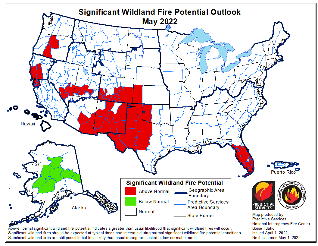
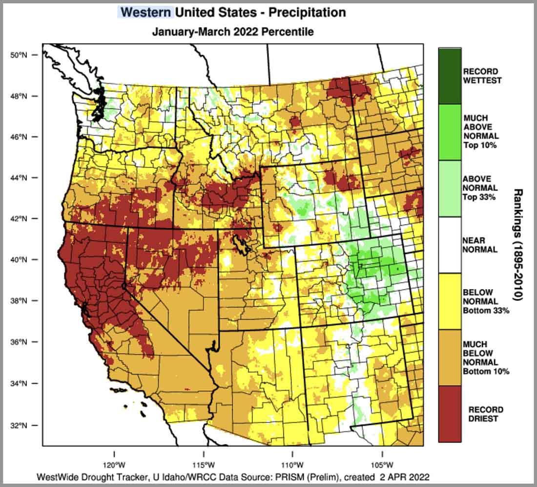
Precipitation from January through March in the 11 Western states was below normal in many locations, but record driest amounts were recorded in areas of Northern California, Southern Oregon, Central Idaho, Northern Nevada, and scattered sections of Montana, Colorado, and Utah. This is based on more than 100 years of data from the WestWide Drought Tracker at the University of Idaho.

The dry weather is already affecting live fuel moisture of the brush in the Santa Cruz Mountains south of San Francisco. On April 1 it was near the lowest ever measured on that date, about 30 percent below average.

low live fuel moisture, Santa Cruz Mountains, California
Live fuel moisture, Santa Cruz Mountains, California. San José State University.

Of course there is a temptation to conclude that extremely dry soils and vegetation in April will lead to more acres burned than average, but the reality is that the weather in the summer has veto power. If conditions during the peak of the western wildfire season are cooler, wetter, more humid, and less windy than typical, it will not necessarily be a busier than average fire season.

However (there is always a “however”) if this dry trend continues through June, and if the weather in the following three months is close to normal, the effects of the current shortages of wildland firefighters are going to be even more noticeable and far-reaching than we saw during the last two years.

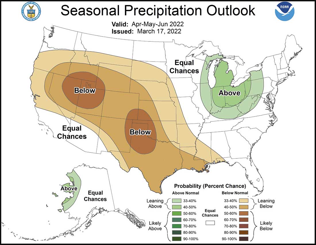
And the three-month forecast for much of the West predicts below normal precipitation.

90-day Precipitation Outlook, March 17, 2022

Seasonal Drought Outlook

Precipitation anomaly Jan-Mar, 2022

Soil moisture anomaly April 2, 2022
NWS, Climate Prediction Center

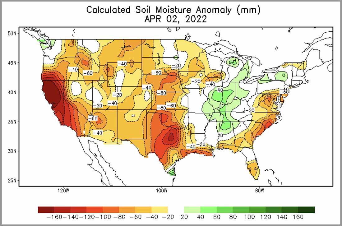
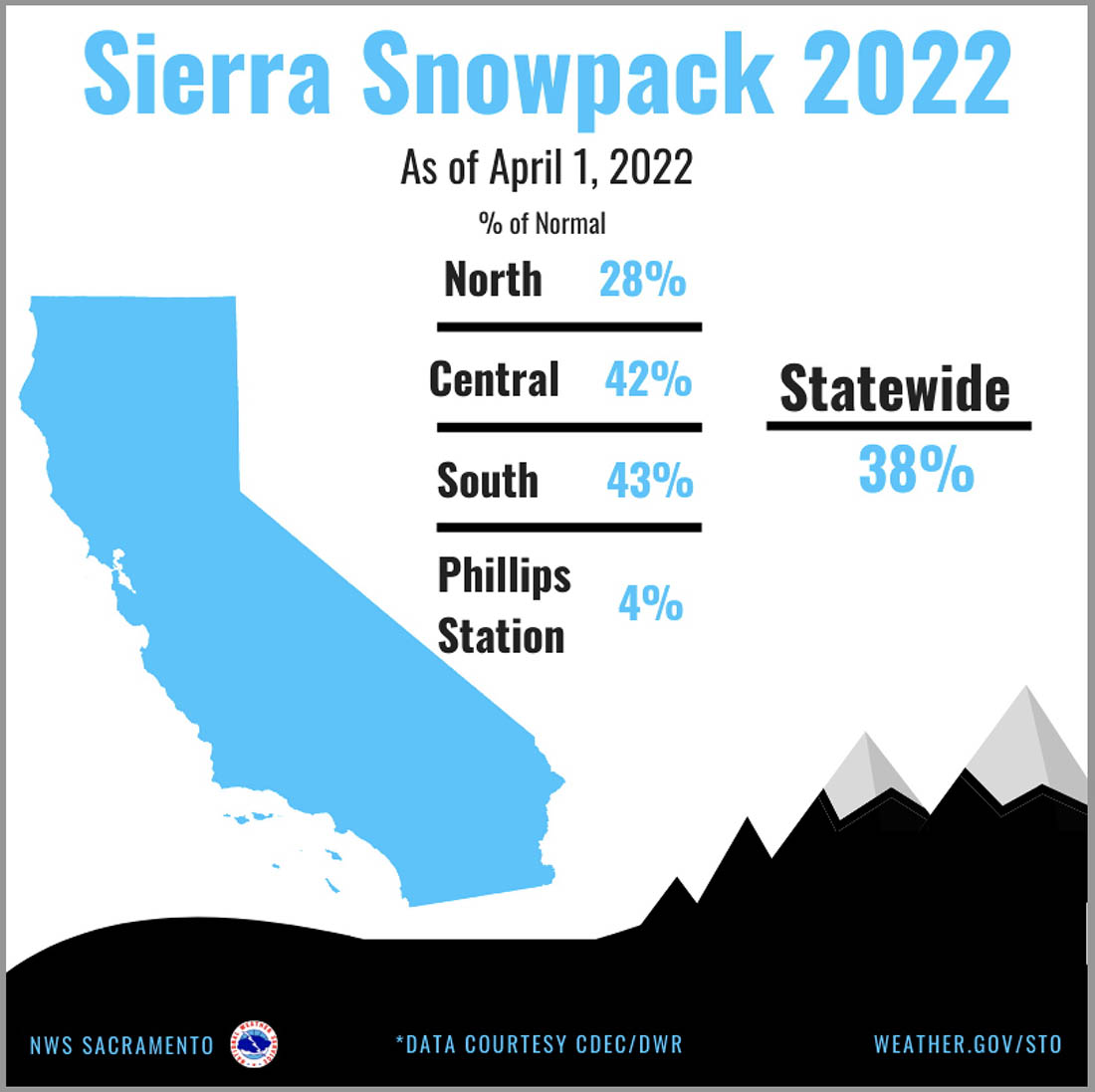
In Northern California the snowpack on April 1 was 28 percent of normal for the date; statewide it was 38 percent.

California Sierra snowpack, April 1, 2022
California Sierra snowpack, April 1, 2022.

Wildfire convection may have contributed to a flood advisory

North of Miami

Smoke and flood advisory

There is a discussion on Twitter about to what extent, if any, fire-induced convection and smoke from a wildfire northwest of Miami contributed to downstream precipitation and a flood advisory north of the city. While it happened on April 1, I don’t see any indication that it is a joke.

There is a possibility that outflow from a nearby thunderstorm interacted with the convection and smoke from the wildfire to intensify the effects.

The thread was started by Philipe Papin, a meteorologist with the NWS National Hurricane Center.

One of the fires in that general area is the 12,000-acre L 30 Fire which has been burning since at least March 28.

Wildfires in the Miami area, April 1-2, 2022
Wildfires in the Miami area, April 1-2, 2022.

Fire shelters made before 2006 may delaminate more than newer versions

Confirmed by testing and actual use in entrapments

Pre-2006 Fire Shelter
Pre-2006 fire shelters may experience greater delamination between the silica cloth and aluminum foil when deployed.

The National Wildfire Coordinating Group’s Equipment Technology Committee has issued an advisory about fire shelters. Actual use on fire entrapments confirmed by testing shows that shelters manufactured before 2006 “function as intended” but may experience greater delamination between the silica cloth and aluminum foil when deployed.

The U.S. Forest Service National Technology and Development Program detected differing levels of fire shelter degradation during two separate entrapments in 2020 where fire shelters were used. Further investigation revealed that those manufactured prior to 2006 showed more degradation.

The NWCG advisory does not describe how serious the delamination is, or the differences in temperature and effects on a person inside who is hoping the device will save their life. Nor does it take the obvious step of recommending any actions that should be taken or not taken, such as discontinuing use of the pre-2006 models. It only says the advisory “provides technical information to support agency-specific decision-making regarding replacement of fire shelters manufactured prior to 2006.” The fact that they issued the advisory, and surrounded the document with yellow and gray slashes (see below), promotes the assumption that it is an urgent concern.

Fire Shelter $326
Fire shelter, from the 2019 Federal Defence Logistics Agency Wildland Fire Equipment catalog.

The failure to take a stand on this important safety issue could be because the agencies do not want to be forced to spend the money to buy new shelters. They are listed in the 2019 Federal Defence Logistics Agency Wildland Fire Equipment catalog starting at $326 for the regular size — without the case. Purchased on the open market the costs are considerably higher. I found prices ranging from $441 to $595.

The advisory is below. Click the arrow at the bottom-left to see the photos on the second page.

[pdf-embedder url=”https://wildfiretoday.com/wp-content/uploads/2022/04/Fire-Shelter-Advisory-3-16-2022.pdf” title=”Fire Shelter Advisory 3-16-2022″]

Higher than average wildfire activity expected in Southern Plains and Southwest, April through June

Prediction released for April through July

wildfire potential April 2022

The forecast for wildland fire potential issued April 1 by the National Interagency Fire Center predicts that over the next three months the potential will be higher than average in the Southern Plains and the southwestern states.

While large sections of Oregon, Washington, and Northern California are expected to be busier for firefighters than average May through July, average conditions are in the forecast for Central and Southern California during the next four months.

The data from NIFC shown here represents the cumulative forecasts of the ten Geographic Area Predictive Services Units and the National Predictive Services Unit.

Below:

  • Excerpts from the NIFC narrative report for the next four months;
  • Additional NIFC monthly graphical outlooks;
  • NOAA’s three-month temperature and precipitation forecasts;
  • Drought Monitor;
  • Keetch-Byram Drought Index;
  • Soil moisture.

“Most of the West, Plains, and Texas remain in drought, with areas of drought also along the Gulf Coast, in South Florida, and in the eastern Carolinas. Most basins in the West are reporting below average snow water equivalent (SWE), but Alaska has above normal snowpack and snow cover.

Climate outlooks indicate likely below normal precipitation from Texas through the southern Rockies and Great Basin, with above normal temperatures likely across much of the contiguous US (CONUS) through spring into summer. Indications for an active severe weather pattern this spring remain from eastern portions of the Plains into the Southeast and Ohio Valley, and critically dry and windy periods will accompany the severe weather for much of the Plains, especially the southern and central High Plains. The North American Monsoon is likely to arrive on time, but potential early moisture surges during June could result in lightning across the Southwest, Colorado, and the southern Great Basin.

“Above normal significant fire potential is forecast across the eastern Carolinas for April and in South Florida through May. The southern High Plains will retain above normal significant fire potential into July, with much of the Plains forecast to have above normal potential by July after green-up and subsequent curing occurs due to anticipated warmer and drier than normal conditions.

“Most of the Southwest is forecast to have above normal significant fire potential in May and June, with potential increasing across southern and western Colorado and southern portions of the Great Basin. Above normal potential will likely expand from central Oregon to southwest Oregon and central Washington by July. Above normal significant fire potential is also forecast to increase across northern California from May into July, with rising potential likely along portions of the Sierra Front. Alaska is forecast to have below normal potential in its panhandle through April, with below normal potential expected across large portions of the Interior through May. Leeward locations of Hawaii are forecast to have above normal potential during June and July.”


wildfire potential May 2022

Continue reading “Higher than average wildfire activity expected in Southern Plains and Southwest, April through June”

Wildfire prompts evacuations southwest of Pigeon Forge, TN

The blaze is being pushed by strong winds

6:32 p.m. ET, March 31, 2022

Map, Hatcher Mountain Fire, 126 p.m. ET march 31, 2022
The red icons represent heat detected on the Hatcher Mountain Fire by satellites as late as 1:26 p.m. ET March 31, 2022.

The Sevier County Emergency Management said at about 3:10 p.m. Thursday that the evacuation area would be reduced shortly. You can type an address at the top-right on the page to see if it is affected.

A mandatory evacuation was ordered Thursday afternoon for Smoky Ridge Way off Wears Valley Road due to increased fire activity.

At 5:15 p.m. ET Thursday fire officials said the Hatcher Mountain/Indigo Lane fire was 3,700 acres and approximately 100 structures had been affected — the same numbers distributed in the 10 a.m. briefing.

Helicopters have been dropping water on the fire since early Thursday morning.

A reporter with WVLT got photos of some of the five pieces of fire apparatus that fire officials said were damaged on the Hatcher Mountain Fire northwest of Gatlinburg, Tennessee yesterday.


10:17 a.m. ET March 31, 2022

Indigo Lane Fire March 30, 2022
Indigo Lane Fire March 30, 2022. Image by @WVLTPat.

In a 10 a.m. briefing on Thursday officials said the wildfire southwest of Pigeon Forge, Tennessee, which is being referred to as the Indigo Lane Fire and Hatcher Mountain Fire, has burned 3,700 acres and “affected 100 structures.” Five fire apparatus vehicles were damaged.

The blaze is in the Wears Valley community of Sevier County six miles northwest of Gatlinburg.

In addition to local fire departments, resources have responded from 70 agencies in Middle and Upper East Tennessee as well as the Tennessee National Guard and the U.S. Forest Service. Two incident management teams are on the scene, an interagency team and a state team.

The Sevierville Convention Center, at 202 Gists Creek Road in Sevierville, is open as an evacuation shelter for persons displaced by the fire.

As the strong weather system moved through the area Wednesday night the weather station at Cove Mountain recorded winds out of the south-southeast and south with sustained speeds of 38 mph at midnight. The relative humidity rose from a low of 16 percent Wednesday afternoon to 92 percent at 6 a.m. Thursday. Less than 1/10 inch of rain fell at that station and another at Pigeon Forge. At 9 a.m. Thursday the wind at Cove Mountain was 21 mph from the south-southwest with 81 percent RH.

The spot weather forecast from the National Weather Service Thursday morning predicts mostly sunny skies with a slight chance of scattered sprinkles late in the morning, minimum RH of 45 percent, and southwest winds 9 to 14 mph with gusts to
around 30 mph.


Continue reading “Wildfire prompts evacuations southwest of Pigeon Forge, TN”

Pilot killed in helicopter crash was former wildland firefighter

Lora Trout had more than 6 years experience on helitack and fire crews in Montana, Colorado, and California

Lora Trout
Lora Trout. Photo via USFS.

This article was first published at Fire Aviation.

A former wildland firefighter with experience on helitack and fire crews was killed in the crash of a helicopter in a Dallas suburb Friday.

After six years on the Teton Interagency Helitack crew in Jackson, Wyoming, Lora Trout left to fulfill her dream of flying helicopters full-time and return to fight fire as a pilot. Prior to her work in helitack she worked as a wildland firefighter on the White River National Forest in Colorado and the Boise National Forest in Idaho. She also worked as a helitack squad boss on the Tonto National Forest in Arizona.

Lora Trout
Lora Trout. USFS photo.

She became licensed as a helicopter pilot and got a job as a tour pilot, then achieved the next step, becoming certified as flight instructor.

Tail rotor
Investigator with tail rotor from the March 25 helicopter crash. ABC 8 image.

Lora was giving a lesson to Ty Wallis Friday when the tail boom separated from the Robinson R44, (N514CD), causing the helicopter to crash and catch fire in a vacant lot in Rowlett, Texas. Both were killed.

“Lora was a dear friend, dedicated coworker, physical fitness leader, and an immediate positive influence to all she knew,” said a statement from the Bridger-Teton National Forest. “Her charismatic wit and strength were evident in all she did, particularly in her passion for aviation and wildland firefighting. To those that knew her, she was a “go to” for advice, help, and humor.”

In a series of Tweets, Elan Head, a helicopter pilot and contributor to Vertical Magazine, said Lora was qualified as a Helicopter Manager, Short Haul, and was an EMT. Ms. Head described Lora as a friend and a “bad ass.” Check out the Twitter thread below (or see it on Twitter).

In a YouTube video, Juan Browne said the main rotor struck the tail boom, causing the separation of the tail rotor assembly.

It appears that the only photos without Lora showing a big smile are when she has her back turned.

Lora Trout
Lora Trout. Photo via USFS.

Our sincere condolences go out to the family, friends, and coworkers of Lora.