Wildfire news, September 14, 2016

Highlights of recent news about wildland fire.

California has fewer inmates available for fighting wildfires

With fewer inmates available for fighting fires, the state of California is turning to civilian crews within their Conservation Corps.

From KCRA:

…But the number of available inmates is declining because counties now oversee most lower-level felons under a law aimed at easing prison overcrowding. In addition, there are fewer incentives for inmates to risk their lives since a federal court broadened an early release program for firefighters to include other inmates.

The state is about 600 inmates short of the 4,300 prisoners who could be available for fire lines. So this year, the California Conservation Corps reopened a camp to train three crews of young civilians to do the same backbreaking work as the inmates. Corps Director Bruce Saito expects to create at least four more fire crews with roughly 15 members each by next summer and a half-dozen new crews during each of the next two years.

The corps has more than 1,400 members, but fewer than 200 currently work alongside local, state and federal firefighters battling blazes in rural areas.

The members include both men and women and range in age from 18 to 25. They enlist for one year and earn the state’s minimum wage of $10 an hour. Military veterans can enroll until they turn 30…

Oregon sues 3 people responsible for starting the Ferguson Fire

Oregon hopes to recover $892,082 from three individuals who they say are responsible for starting the Ferguson Fire that burned 200 acres and destroyed two structures in Klamath County in July 2014.

The suit alleges that Joe Askins started a campfire, then took a nap. When he awoke, the campfire had escaped. Askins also said “I’ll take all the blame for the fire,” according to the lawsuit.

More evidence that beetle-killed forests do not increase the risk of catastrophic wildfires.

An article at News Deeply summarizes several research studies which mostly concluded that beetle-killed forests do not burn more severely than forests that have not been attacked by the insects. This is in spite of statements to the contrary by the Secretary of Agriculture, a spokesperson for CAL FIRE, and media stories about trees that are now part of a “tinder box”.

Air tanker 132 starts contract in Australia

air tanker 132 australia
Air Tanker 132 is reintroduced to the media in New South Wales, Australia. Photo by Sgt. Brett Sherriff, Royal Australian Air Force.

Fire Aviation reports that Coulson’s Air Tanker 132 started its contract with New South Wales on September 6, helping to provide air support for wildland firefighters in Australia. This is the second year in a row that the L-382G, a variant of the C-130 platform, has worked down under during their summer bushfire season.

Cheyenne is concerned about the effects of the Snake Fire on their water system

“The location of the fire is close proximity to our major watershed collection area for the Hog Park Reservoir” said Dena Egenhoff, the Board of Public Utilities’ (BOPU) Water Conservation Manager. “We are unable to know the impact of the Snake Fire at this time, but the location suggests there may be some adverse impacts to the City of Cheyenne’s water collection system.” As of September 11, 2016, the Hog Park Reservoir is 91.8% full

For Cheyenne, BOPU collects water in the Little Snake River drainage from snow melt and streams and transports it under a mountain by a tunnel to the eastside of the Continental Divide. That water is then stored in Hog Park Reservoir. From there, the collected water from Hog Park Reservoir is traded for water in Rob Roy Reservoir which can more easily be transported without pumping to Cheyenne. “In this way, the amount of water can be exchanged between the two different Mountain Ranges with all water rights being satisfied,” said Dena Egenhoff.

The Snake fire is in south-central Wyoming just north of the Colorado border. It is 115 air miles miles west of Cheyenne, and 20 miles west of the 38,000-acre Beaver Creek Fire that has been burning in Colorado and Wyoming since July 19, 2016.

Precipitation on Berry Fire allows reopening of south entrance to Yellowstone

The highway reopened September 13 after being closed since September 11.

Originally published at 1:39 p.m. MDT September 14, 2016.

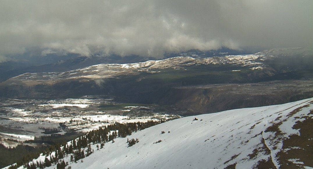
Precipitation, which included snow in the higher elevations, put a damper on the Berry Fire and allowed officials to reopen the south entrance into Yellowstone National Park and Highway 89 on September 13. The highway had been closed since September 11 when the fire ran to the northeast for six miles in northwest Wyoming. The blaze ran for about six miles from Grand Teton National Park toward the northeast, burning another 6,000 acres, and forced evacuations at the Flagg Ranch, the north entrance station into Grand Teton National Park, and Sheffield Campground on the Bridger-Teton National Forest.

On Wednesday crews will continue to secure the Flagg Ranch area, which is still closed, and improve safety along the Grassy Lake Road corridor.

Mt. Washburn Yellowstone
This was the view from Mt. Washburn in Yellowstone National Park looking northeast at 1:44 p.m. MDT, September 14, 2016. NPS photo.

Time-lapse video of Alcorn Fire in Utah

Bill Blevins shot this fascinating time lapse of the Alcorn Fire on September 11, 2016 from a point 3 miles southwest of the fire. He said it was captured at one frame every three seconds.

The fire burned 730 acres 25 miles southwest of Provo, Utah. Firefighters expect full containment today, September 13.
Thanks and a tip of the hat go out to Jim.

Wildfire smoke map and Red Flag Warnings, September 12, 2016

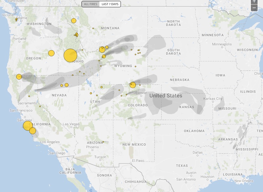
wildfire smoke map
Distribution of smoke from wildfires, September 11, 2016. Ecowest.org

red flag warnings september 12, 2016

The National Weather Service has posted Red Flag Warnings or Fire Weather Watches for areas in Washington, Oregon, California, Nevada, Utah, and Colorado.

The Red Flag map was current as of 11:45 a.m. MDT on Monday. Red Flag Warnings can change throughout the day as the National Weather Service offices around the country update and revise their forecasts and maps. For the most current data visit this NWS site. However, that site has not been properly displaying warning areas in recent days. This one may work better.

Berry Fire, requires closure of south entrance to Yellowstone, September 11

On September 11 the fire spread across Highway 89, closing the south entrance to Yellowstone National Park and forced evacuations at the Flagg Ranch, Grand Teton National Park entrance station, and a Forest Service campground. The highway reopened on September 13.

Above: The Berry Fire crosses Highway 89, September 11, 2016. InciWeb photo. 

(Originally published at 10:59 a.m. MDT September 12, 2016. Updated at 1:50 a.m. MDT September 14, 2016.)

On September 11 winds gusting up to 35 mph on Sunday pushed the Berry Fire which had been relatively quiet for the last week, across Highway 89 for a second time, closing the south entrance into Yellowstone National Park.

The fire ran for about six miles toward the northeast, burning another 6,000 acres, and forced evacuations at the Flagg Ranch, the north entrance station into Grand Teton National Park, and Sheffield Campground on the Bridger-Teton National Forest. An overnight mapping flight determined that the Berry Fire burned very close to the facilities at the Flagg Ranch and appeared to have spread again from the John D. Rockefeller Jr. Memorial Parkway into the Bridger-Teton National Forest and then into Yellowstone National Park.

Berry Fire map
The red line was the perimeter of the Berry Fire at 1 a.m. MDT September 12, 2016. The white line was the perimeter on August 29. Credit: Wildfire Today, Google Earth, USFS.

Highway 89 is closed between Leeks Marina junction on the south and Grant Village in Yellowstone NP on the north side.

Since the fire started July 25 it has been managed but not totally suppressed in order to replicate natural conditions which includes periodic fire. It has now burned 20,801 acres.

Much of the western United States Sunday was under a Red Flag Warning due to dry and windy conditions. During the afternoon the Burro Hill weather station southeast of the fire recorded a high temperature of 75 degrees, 10 percent relative humidity, and west to southwest winds of 9 to 15 mph gusting at 23 to 35 mph. The weather will drastically change on Monday and Tuesday with lower temperatures, higher humidity, and a 30 to 60 percent chance of precipitation.

BLM Engine 5645
In August the crew of Las Vegas BLM Engine 5645 assisted with public information at the north entrance to Grand Teton National Park. InciWeb photo.

Articles on Wildfire Today tagged “Berry Fire”.

Elevated wildfire danger in 11 states, September 11, 2016

red flag warnings

The National Weather Service has posted Red Flag Warnings or Fire Weather Watches for areas in Washington, Oregon, California, Idaho, Nevada, Arizona, Utah, Colorado, Wyoming, Nebraska, and South Dakota

The Red Flag map was current as of 11:45 a.m. MDT on Sunday. Red Flag Warnings can change throughout the day as the National Weather Service offices around the country update and revise their forecasts and maps. For the most current data visit this NWS site. However, that site has not been properly displaying warning areas in recent days. This one may work better.