Red Flag Warnings and Fire Weather Watches, February 20, 2022. NWS.
The National Weather Service has issued a Red Flag Warning in effect Sunday for an area in the East Central Plains in Eastern New Mexico. The forecast calls for 8 to 13 percent relative humidity and 15 to 30 mph winds gusting out of the west at 40 mph.
Similar conditions are predicted for Monday in Southeast New Mexico and Eastern Texas where a Fire Weather Watch is in the forecast for 10 percent relative humidity and southwest winds of 15 to 25 mph gusting to 35. It is likely the Watch will be upgraded to a Red Flag Warning on Monday.
The Hot-Dry-Windy Index for Western Texas shows the fire danger increasing Sunday and Monday, reaching above the 75th or 90th percentiles Monday.
They found that ignitions on Forest Service lands accounted for fewer than 25% of the most destructive wildfires
Research led by Oregon State University shows that fires are more likely to burn their way into national forests than out of them. The findings contradict the common narrative of a destructive wildfire igniting on remote public land before spreading to threaten communities, said Chris Dunn of the OSU College of Forestry.
The study, which looked at more than 22,000 fires, found that those crossing jurisdictional boundaries are primarily caused by people on private property. It also showed that ignitions on Forest Service lands accounted for fewer than 25% of the most destructive wildfires – ones that resulted in the loss of more than 50 structures.
“In the old framing, public agencies bear the primary responsibility for managing and mitigating cross-boundary fire risk and protecting our communities, with their efforts focused on prevention, fuel reduction and suppression,” Dunn said. “This has been the dominant management approach of years past, which is failing us.”
Location of destructive wildfires (> 50 structures lost) between 2000 and 2018 that originated on (a) USFS lands, and (b) non-USFS lands. Fire locations are symbolized by magnitude of structure loss. Relatively few destructive fires originated on USFS lands. The most destructive USFS and non-USFS fires during this time are the Cedar fire and the Camp fire.
The findings, published February 15, 2022 in Nature Scientific Reports, follow by a few weeks the Forest Service’s release of a new 10-year fire strategy, Confronting the Wildfire Crisis. The strategy aims for a change in paradigm within the agency, Dunn said.
“We are long overdue for policies and actions that support a paradigm shift,” he said.
Scientists including Dunn and OSU’s Will Downing investigated 27 years of fires that crossed jurisdictional boundaries. The collaboration also included scientists from Colorado State University and the Forest Service’s Rocky Mountain Research Station.
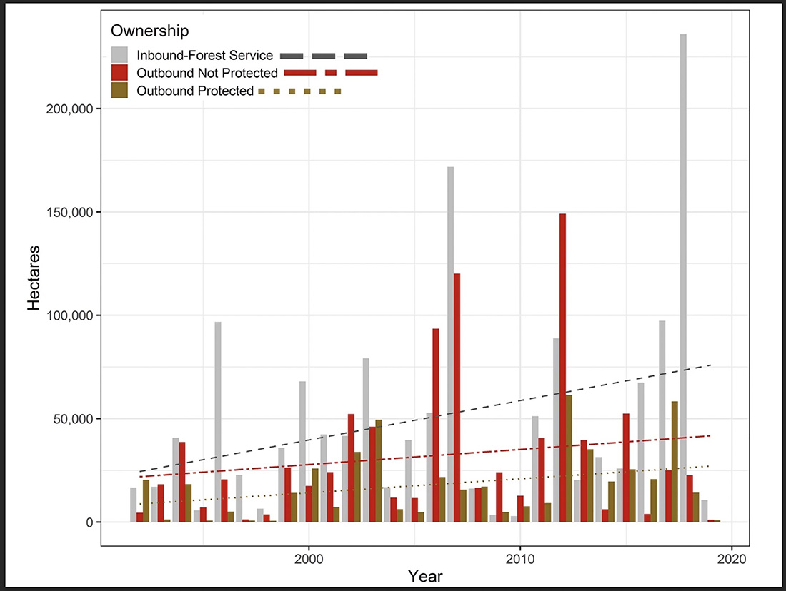
Cross-boundary fires consumed just over 17 million acres during the study period of 1992 to 2019, and about half of the burned area was Forest Service land. The study area covered almost 141 million acres across 11 states and included 74 national forests.
Area burned by CB fires derived from FIRESTAT data and binned by ownership category. Blue dots represent decadal averages of inbound and outbound acres combined. CB fire activity increased substantially during our study period. Area burned on USFS lands by fires originating on other ownerships (“inbound”, gray) has increased more rapidly than area burned on non-USFS lands. “Outbound not protected” refers to fires that burned out of a Forest onto land not protected by the Forest Service. Ownership categories are described in more detail in the Methods section of the paper.
Of all ignitions that crossed jurisdictional boundaries, a little more than 60% originated on private property, and 28% ignited on national forests. Most of the fires started due to human activity.
“The Forest Service’s new strategy for the wildfire crisis leads with a focus on thinning public lands to prevent wildfire intrusion into communities, which is not fully supported by our work, or the work of many other scientists, as the best way to mitigate community risk,” Dunn said.
Home Ignition Zone
“A substantial portion of the wildfire problem is a community destruction problem,” added Michael Caggiano of Colorado State. “The Forest Service can contribute to an advisory or facilitation role to address the home ignition zone, including fire resistant design and zoning, and fuels management on private lands, but states, local government and homeowners are better positioned than the USFS to manage those components of wildfire risk.”
A paradigm shift that could mitigate wildfire risk would begin with the recognition that the significant wildfires occurring in western states is a fire management challenge with a fire management solution, not a forest management problem with a forest management solution, Dunn said.
“The only way we are going to address the wildfire problem on large public lands at the scale of the challenge is through the effective and efficient management of wildfires over the long run,” he said.
Dunn said that means allowing some fires or portions of fires to burn to provide risk reduction and ecological benefits, identifying and preparing locations where suppression is likely to be effective, and developing strategies to rapidly distribute resources to where they are most needed and can do the most good.
“Our research has significant potential to inform and guide development of effective cross-boundary risk mitigation strategies, including identifying where and how work on the ground can be most effective,” he said. “The main source of our communities’ exposure to wildfire risk is clearly not our national forests.”
The study showed that in many cases, national forests were a net receiver of cross-boundary wildfire rather than a source, and that those fires tend to happen in areas with higher densities of roads and people.
Dunn credits the Forest Service for accepting the modern realities of wildfire and for embracing collaborative governance and cross-boundary partnerships. He added that managing fire in multijurisdictional landscapes has become a centerpiece of wildfire strategic planning and that evidence suggests fire transmission across boundaries will continue to increase.
Legislation
“As the Forest Service’s strategy moves forward, we think there could be opportunities to learn from what their state partners are doing, such as the more comprehensive policies passed in Oregon in 2021,” he said. “Oregon’s omnibus wildfire bill is a science-driven approach that recognizes the shared responsibility we all have in adapting to the fire environment.”
The legislation requires those homes at greatest risk to mitigate at the home ignition zone and also addresses landscape resilience and improved wildfire response.
Dunn calls it “the type of comprehensive policy we need to address the multitude of impacts wildfires have on communities, ecosystems, industry, etc. It recognizes that the Forest Service is neither the sole source of the problem nor the sole solution to the problem, but rather one of many pieces to a paradigm shift society needs to make.”
Matthew Thompson and Karen Short of the Rocky Mountain Research Station also took part in the cross-boundary fire study, which was partially funded by the Forest Service.
From Oregon State University.
Authors of the research paper: William M. Downing, Christopher J. Dunn, Matthew P. Thompson, Michael D. Caggiano, and Karen C. Short
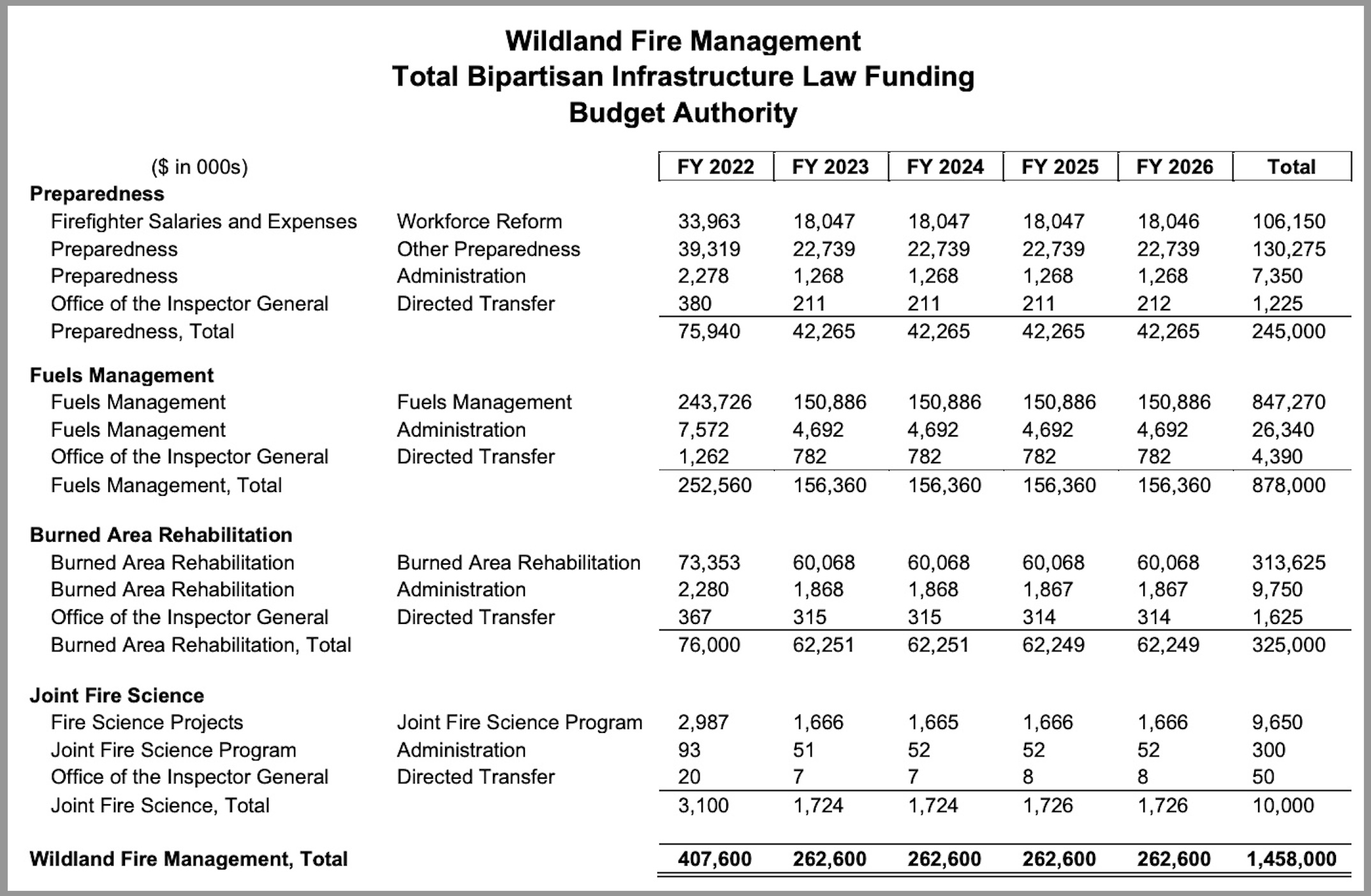
Department of the Interior’s outline for spending funds appropriated by the Bipartisan Infrastructure Law for wildland fire, fiscal years 2022 through 2026.
The Department of the Interior (DOI), as required by the Bipartisan Infrastructure Law signed by President Biden on November 15, 2021, has released an outline for spending the $1.5 billion that the legislation appropriated to be used by the Department for wildland fire. Four agencies within the DOI have significant wildland fire responsibilities: Bureau of Land Management, Park Service, Fish and Wildlife Service, and bureau of Indian Affairs.
In January the US Forest Service announced how it will spend the $2.42 billion the agency will receive, and also here in February.
Before the bill was passed, we compiled a summary of the legislation’s provisions that relate to wildland fire.
Below are excerpts from a 13-page DOI document that explains how the new funds will be used.
…The Bipartisan Infrastructure Law (BIL) provides a total of nearly $1.5 billion to DOI for the Wildland Fire Management (WFM) programs and activities shown in the table below. Specifically, Division J appropriates $1,458,000,000. This funding is provided as emergency appropriations and is available for obligation until expended. Division J further specifies in which fiscal year (FY) amounts become available for obligation from FY 2022-FY 2026, as reflected in the table [above]. The U.S. Department of Agriculture (USDA) Forest Service received complementary appropriations for wildland fire management, and the two agencies are collaborating on and coordinating implementation of the BIL.
Preparedness – Workforce Reform: The BIL provides $120.0 million over five years to increase the compensation of Federal wildland firefighters, convert more firefighters to permanent, year-round employment, and support the health and safety of firefighters. The law directs DOI and USDA Forest Service to increase compensation for firefighters in some geographic areas and to work with the Office of Personnel Management (OPM) to establish a wildland firefighter occupational series. Further, DOI and USDA Forest Service are required to establish mitigation strategies for line-of-duty environmental hazards and firefighters’ mental health.
Other Preparedness: The law provides another $125.0 million over five years for other activities that will increase America’s preparedness to respond to wildland fire. They include support for workshops and training for firefighters, equipment, satellite detection and reporting, and wildfire detection and monitoring, and a pilot program to support Tribal Nations and local governments in wildfire response.
Fuels Management: The law provides $878.0 million over five years to plan and implement fuels management. This work will protect vulnerable communities from wildfire while preparing our natural landscapes for a changing climate. The law’s funding is intended to support mechanical thinning; prescribed fire; employing contractors, young adults, veterans, and Tribal Nations’ youth; and other fuels management.
Burned Area Rehabilitation: The law provides $325.0 million over five years to complete post-fire restoration activities. These actions help mitigate the damaging effects of wildfires and set landscapes on a path towards natural recovery and climate resilience.
Joint Fire Science Program: The law provides $10.0 million to DOI over five years to study and research wildland fire through the Joint Fire Science Program, which DOI and USDA jointly administer. The program will use the funding to conduct research on climate change interactions, smoke management concerns, impacts on diverse populations, and management actions that will make ecosystems more wildfire and drought resistant.
Funding for the Office of the Inspector General and Administration: The BIL requires that 0.5 percent of the appropriations be transferred to the Office of the Inspector General (OIG) and provides that DOI may use up to 3.0 percent of the appropriations for “salaries, expenses, and administration.” These amounts are reflected in the table on page 3.
Timeline for Implementation – FY 2022 and Later Years
The law establishes several deadlines that will serve as milestones for implementation, including the following:
Beginning October 1, 2021 (no deadline for completion set in the law): DOI and USDA Forest Service will:
Seek to convert not fewer than 1,000 seasonal wildland firefighting positions to permanent year-round positions that are full-time and reduce hazardous fuels on Federal land not fewer than 800 hours per year (each position); and
Increase the salary of wildland firefighters by an amount equal to the lesser of $20,000 or 50 percent of base salary if the DOI and USDA Secretaries and the OPM Director determine that a position is in a geographic area where it is difficult to recruit or retain Federal wildland firefighters.
Mid-December 2021: DOI, USDA, and DHS (through the FEMA Administrator) jointly established a Wildland Fire Mitigation and Management Commission to (1) study and make recommendations on preventing, mitigating, suppressing, and managing wildland fires, and (2) rehabilitate land devastated by wildfires. The Secretary of the Interior, the Secretary of Agriculture, and the FEMA Administrator serve as co-chairs, and other Commission members will be appointed. The Commission will issue a report within one year of the first Commission meeting.
March 14, 2022 (120 days post-enactment): DOI and USDA Forest Service will establish a five-year monitoring, maintenance, and treatment plan.
May 13, 2022 (180 days post-enactment): DOI and USDA Forest Service will develop a distinct wildland firefighter job series, in coordination with OPM.
Annually December 31, 2022-2026: DOI and USDA Forest Service will submit a report to Congress on the number of acres of land on which projects carried out using the BIL’s treatment funds improved the Fire Regime Condition Class of the land.
October 1, 2022: DOI and USDA Forest Service will develop and adhere to recommendations for mitigation strategies for wildland firefighters to minimize exposure to line-of-duty environmental hazards; and to recognize and address mental health needs, including post-traumatic stress disorder care.
September 30, 2027: By no later than this date, DOI and USDA will conduct restoration treatments and improve the Fire Regime Condition Class of 10,000,000 acres of Federal or Tribal lands identified as having a very high wildfire risk potential and that are located in the wildland-urban interface or a public drinking water source area.
Workforce and Compensation
Workforce Reform: The BIL provides DOI a total of $120.0 million over five years for firefighters’ compensation, position conversions, and health and safety. DOI will work with USDA Forest Service on strategies to increase firefighters’ compensation; convert hundreds more firefighters to full-year, permanent positions; and address firefighters’ mental health needs.
Workforce Assessment: Human capital is the most important investment for effective wildland fire management. Prior to enactment of the BIL, DOI decided to undertake an assessment of the wildland fire management workforce. This assessment will be valuable in implementing the BIL. DOI’s Federal Consulting Group, which is assisting the WFM program, has contracted for a Wildland Fire Workforce Assessment that will serve as baseline information about wildland fire personnel, including geographic location, pay and compensation, diversity, classification, and other factors to inform the determination of sustainable and effective workforce capacity needs. The assessment will be delivered to DOI by May 31, 2022.
Coordinated, Interagency Workforce Working Groups: To lead toward the establishment of a wildland firefighter series (deadline 180 days: May 13, 2022), DOI is participating in interagency working groups with OPM and USDA Forest Service to review the current classification series of wildland fire personnel. In addition to position classification and job series, these groups are also evaluating pay, compensation, and other benefits.
Compensation Increases for 2022: On June 30, 2021, the President announced compensation increases and retention incentives for the lowest-paid wildland firefighters. These increases were implemented over the summer for a six-month period covering through December 31, 2021. For 2022, DOI and USDA Forest Service issued guidance that no firefighter should be hired at a salary of less than $15 per hour. (Subsequently, OPM issued guidance that applies to positions governmentwide.) DOI and USDA Forest Service are coordinating with OPM on an analysis to propose a special rate request for firefighters.
Pre-Planning Fire Response Workshops and Training: DOI and USDA Forest Service, in coordination with stakeholders, will hold workshops and training for staff, non-Federal firefighters, and Tribal fire crews to effectively respond to wildfires and assist in increasing the pace and scale of vegetation treatments. The plan is for USDA Forest Service to lead on pre-planning fire response workshops that develop potential operational delineations and select potential control locations, and for DOI to lead on wildland firefighter training.
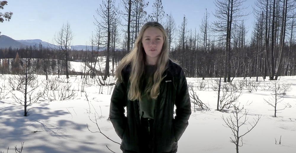
Linnea Gebauer. Still image from her documentary about wildland fire.
High school student, Linnea Gebauer submitted a video for the national C-SPAN StudentCam competition. The prompt from C-SPAN was, “How does the federal government impact your life?” She chose to talk about wildland fire.
Having created and edited videos, to me it is obvious that Linnea put a great deal of time and effort into research, planning, interviewing subject matter experts, and editing the dozens of clips into the finished product. Excellent job, Linnea!
StudentCam is C-SPAN’s annual national video documentary competition that encourages students to think critically about issues that affect our communities and our nation.
This year the competition was open to students in grades 6-12. The submission deadline was Thursday, January 20, 2022. With cash prizes totaling $100,000 each year, C-SPAN awards prizes to the top 150 student documentaries and teachers that are identified as advisors.
Airport Fire, photo posted at 11:27 a.m. PT Feb. 17, 2022 by @captain2500agl
The growth of the Airport Fire slowed substantially by mid-day Thursday, judging from photos taken in the morning and afternoon. There are still a few residual smokes showing in the image shot by the camera on Marzano Peak at 1:56 p.m., but no dark gray columns.
Airport Fire, from the Marzano Peak camera at 1:56 p.m. Feb. 17, 2022 looking west-southwest.
Caltech, the operator of the Owens Valley Radio Observatory, said that as of Thursday morning at 11 a.m. personnel were reporting that a perimeter had been established around buildings and the main threat to the structures had passed. Assessment of instrumentation and antennas in the field surrounding the main facility structures, however, was ongoing.
The #AirportFire in California’s Eastern Sierra near the town of Big Pine is currently 3900 acres, 0% contained, and threatening the area near the Owens Valley Radio Observatory, a place near and dear to my heart. ? pic.twitter.com/BesGIxVrr5
CAL FIRE said at 9:53 a.m. Thursday that the Airport Fire had burned 3,900 acres.
Updated 9:47 a.m. PT Feb. 17, 2022
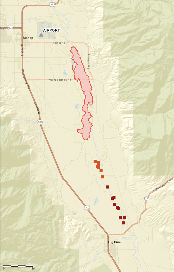
Map, Airport Fire. The red area shows the location of the fire mapped Wednesday afternoon by FIRIS. The red squares represent heat detected by a satellite at 8 a.m. PT, Feb. 17, 2022.
The map of the Airport Fire above is more accurate than our earlier map.
9:10 a.m. PT Feb. 17, 2022
Map of the Airport Fire showing heat detected by a satellite as late as 2:15 a.m. Feb. 17, 2022. The yellow dots exaggerate the extent of the fire, at least in its width. Many of the yellow dots are very questionable. The red dots appear to be more accurate. The gap between the yellow and red dots is likely the result of the light vegetation burning and cooling between the two satellite passes, which were about 11 hours apart.
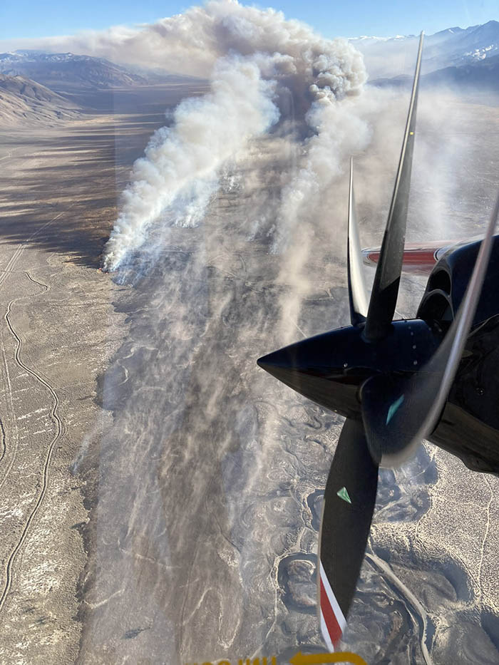
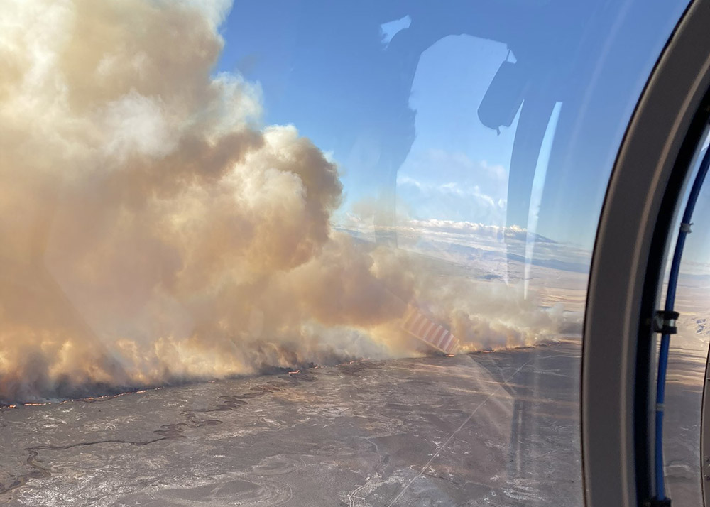
The Airport Fire was very active Wednesday night. When the sun rose Thursday it spanned for about 13 miles from the airport in Bishop, California south to Big Pine. CAL FIRE reports that evacuations have been ordered for properties in Big Pine that are east of US Highway 395. The town has a population of about 1,500.
CAL FIRE dispatched six S-2 air tankers Thursday at about 8 a.m.
Areas that are threatened include two research facilities, White Mountain Research Center and Owens Valley (Caltech) Radio Observatory. Both were evacuated Wednesday.
The blaze started Wednesday afternoon near the Eastern Sierra Regional Airport at Bishop.
Photos taken from Marzano Peak early Thursday morning showed active fire near Big Pine. In the southernmost area of the fire dense, dark smoke was visible which could indicate heavy fuels, such as structures or vehicles burning.
Airport Fire, from the Marzano Peak camera at 6:15 a.m. Feb. 17, 2022 looking west-southwest.Airport Fire, from the Marzano Peak camera at 9:07 a.m. Feb. 17, 2022 looking west-southwest.
The wind, which on Wednesday was out of the north at 28 mph gusting up to 50 mph, slowed during the night but was still strong, 15 to 22 mph gusting at 26 to 32 mph with the relative humidity in the mid-30s. At 8:20 a.m. Thursday the Big Pine weather station recorded 15 mph north-northwest winds gusting to 21 mph while the relative humidity was 40 percent.
The forecast for Big Pine on Thursday is for 56 degrees, 16 percent relative humidity in the afternoon, and 10 to 14 mph winds out of the northwest gusting until noon at 20 mph. These conditions will be conducive to active spreading of the fire, as long as the fuel is continuous.
Resources assigned to the fire Thursday morning include 66 fire engines, 7 water tenders, 1 helicopter, 16 hand crews, and 7 dozers for a total of 432 personnel.
Map, Airport Fire at approximately 5 p.m. Feb. 16, 2022, looking north. By FIRIS aircraft, via Muni-Captain.
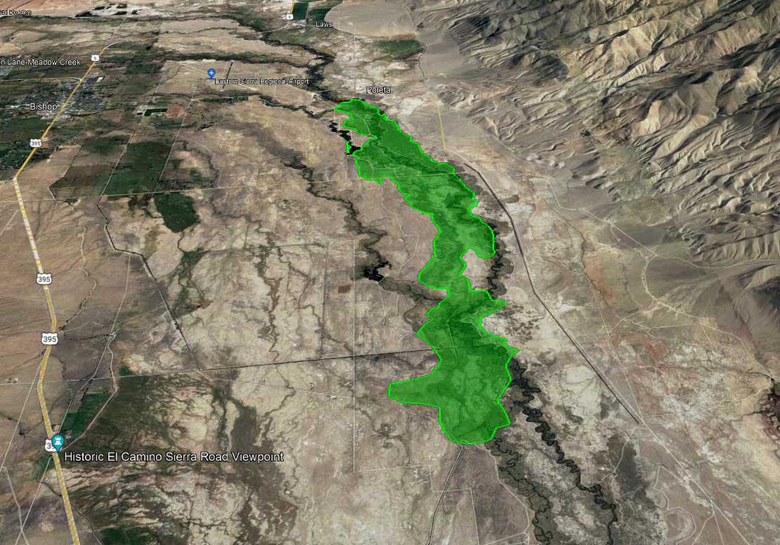
A fire in the northern end of California’s Owens Valley has burned about 2,156 acres, according to the FIRIS mapping aircraft at 4:45 p.m. PT Wednesday.
The incident is three miles east of Bishop and one mile southeast of the Eastern Sierra Regional Airport. Aircraft are having difficulty flying safely and dropping retardant accurately in the very strong winds gusting out of the north at 28 mph gusting at 32 to 50 mph while the relative humidity is 30 percent.
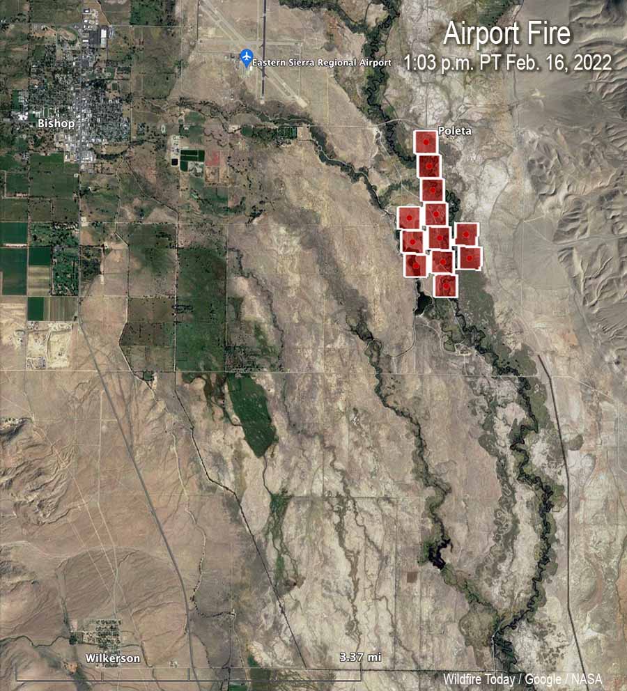
Map, Airport Fire, heat detected by satellite at 1:03 p.m. Feb. 16, 2022.
The wind is pushing it to the south. The CHP reports it has crossed Collins Road, which is five miles south of Bishop.
CAL FIRE reported at 5:38 p.m. that the town of Big Pine is being evacuated. The agency said the evacuation center is at the Bishop Senior Center, 506 Park Ave., in Bishop.
Airport Fire, posted by CAL FIRE BDU at 4:54 p.m. Feb. 16, 2022.
Below is video, visual and infrared, of the Airport Fire southeast of Bishop, California at 4 p.m. PT Feb. 16, 2022. Shot by the Orange County FIRIS aircraft, Intel 12. When in infrared mode, the bright white areas represent heat from the fire.
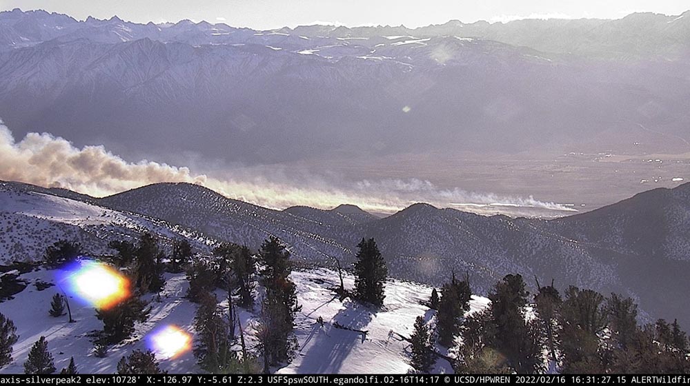
Airport Fire, posted by CAL FIRE BDU at 4:54 p.m. Feb. 16, 2022.Airport Fire, as seen from the Silverpeak 2 camera at 4:31 p.m. Feb. 16, 2022.