Patent describes using drone swarm to suppress wildfire

Researchers performed calculations to determine how many drones would be needed for attacking a wildfire

swarm of collaborative UAVs fire
Diagram from the patent

(This article was first published on FireAviation.com)

The person who was awarded a patent in 2017 for describing a system of drones that could be used to drop liquids on wildfires wrote a paper earlier this year with two other authors that claims to have determined how many drones would be needed for suppressing a small section of a fire.

The patent, #WO2017208272A1, awarded to Marco Ghio, is quite vague and does not supply any technical details. It says that instead of applying fire retardant or water in a conventional manner, a “rain” concept would be used:

Dropping small quantities of firefighting liquid or drizzling it over the fire, and its subsequent spreading on a large area instead of in a concentrated manner. This method, both theoretically and experimentally, is acknowledged as being particularly effective, whereas, on a practical level, it is effectively used in domestic and/or industrial firefighting systems.

swarm of collaborative UAVs fire
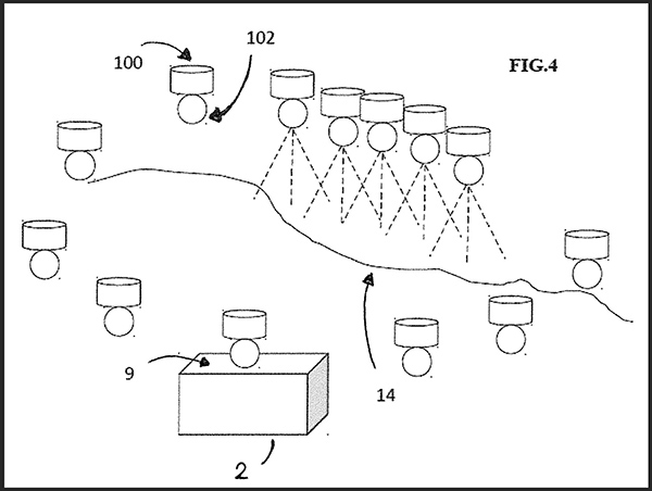
Figure 1. (a,b) Representations of the proposed firefighting system based on the use of a swarm of collaborative UAVs. (From the research)

In the United States fire retardant dropped from an approved air tanker is applied at coverage levels ranging from 1 to 9 gallons per 100 square feet, depending on the situation. It is not clear what coverage level “rain” would produce.
Drawing from the patent drones firefighting
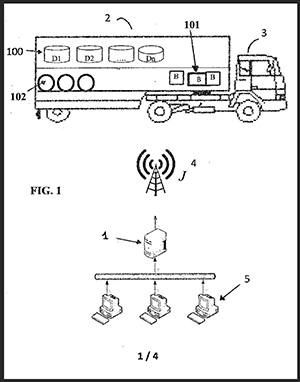
Drawing from the patent

The patent specifies that drones would transport the liquid in removable containers. Upon returning empty to the mobile base the containers would be autonomously replaced with full containers, along with a charged battery if needed.

The drones and the other equipment would be transported in standard metal shipping containers which would be strategically positioned. The system would include “a control unit for the coordination of missions, the flight paths to be followed, and the selection of the ideal drop points optimized according to the environmental conditions.”

Details about how all of this would be accomplished are not specified.

The patent and the research paper written by Mr. Ghio,  Elena Ausonio, and Patrizia Bagnerini assumes that the cargo capacity of the drones would be 5 to 50 liters (1 to 13 gallons), much less than currently carried by helicopters (up to 3,000 gallons) and fixed wing aircraft (up to 17,500 gallons) that routinely fight wildfires.

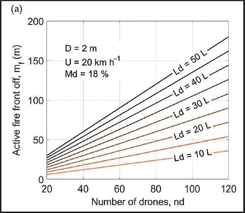
Their analysis (below) takes into account wind speed, flame length, the length of fire line to be suppressed, and the dead fuel moisture. It indicates that about 75 linear meters (246 feet) of the fire’s edge could be extinguished with 120 drones each carrying 20 liters (5 gallons) or 80 drones carrying 30 liters (8 gallons). The vegetation is assumed to be grass or brush, but not timber. The example below assumes that the wind speed is 20 km/hour (12 mph) and the dead fuel moisture is 18 percent. A moisture content of 18 percent for 1-hour and 10-hour time lag fuels is quite high for a very active wildfire. It should not be very difficult to suppress a  fire under those fuel conditions.
Number of drones needed to suppress wildfire
Figure 4a shows the linear meters of fire that can be arrested by using the firefighting system. For example, approximately 70–75 linear meters of active front can be extinguished with 120 drones each carrying 20 L or with 80 drones carrying 30 L. Assumptions are that the wind speed is 20 km/hour and the dead fuel moisture is 18 percent. (from the research)

Our take

In my opinion the most difficult part of using drones to assist firefighters would be applying the retardant or water at the exact location where it can be useful. That is difficult enough when you have good communication with ground personnel, adequate aerial supervision, and experienced highly qualified air crews in helicopters or air tankers.

I don’t think the principle of “rain” in the application of retardant or water from dozens or hundreds of drones is a thing, at least when you’re talking about drones that can just carry a few gallons of water and must have the batteries replaced every 20 minutes. The suppressant still has to be delivered in a timely manner in a quantity and at the location where it can be useful. Maybe when drones are carrying 50 to 100 gallons of water, and the technology improves for placing the retardant on target, it might be useful in very remote areas when the fire is very small, less than 1/10 of an acre, and the wind speed does not exceed 5 mph.

Rain Industries is working on an Unmanned Aerial System (UAS) that could carry up to 400 pounds of cargo, or 50 gallons of water.

Drone Amplified, the developer of the IGNIS prescribed fire system currently being used for aerial ignition, and Parallel Flight Technologies, have received a $650,000 grant from the US Department of Agriculture to support further development of a large-scale Unmanned Aerial System (UAS) for prescribed fire. Parallel says their hybrid gas/electric UAS can carry 100 pounds for up to two hours, numbers that are much larger than battery operated drones. When paired with the upgraded aerial ignition payload under development which will hold and dispense 3,500 incendiary spheres, it will have eight times the payload carrying capacity of drones being used today, and ten times the flight duration.

The paper was published by MDPI, which is food for thought.

Interpretive exhibit about forests and fire opens in Truckee, California December 10, 2021

Forest ecology and its relationship with Fire

Forest Fire exhibition

FOREST⇌FIRE is an inter-disciplinary, multi-sensory installation connecting art, the humanities and science. Debuting at the Truckee Community Recreation Center in Truckee, California December 10, 2021, it flows thematically through past, present and future, utilizing painting, textiles, beadwork, sculpture, photography and more, to tell the story of the Forest ecology and its relationship with Fire.  Of how indigenous people, using low intensity fire, created and maintained the West’s pre-European, old growth forest for thousands of years, of why our forests are currently in ecological collapse, and what can be done immediately to prevent the loss of our Forest.

Through the story and artwork of 19 California writers and artists, the exhibition:

  • Shares a science-based solution to catastrophic fire.
  • Addresses the paradox that some trees need to be removed to save the Forest.
  • Explains why fire needs to become our partner in returning the Forest to resiliency.
  • Provides a vision of what a healthy future forest actually looks like.
  • Offers an economically sustainable, hopeful future for the Forest.
  • Aims to activate a transformative cultural understanding that we learn to live as a part of Nature, rather than apart from Nature in facing Climate Change.

Bringing our forests back into equilibrium (⇌) with fire via small tree and slash reduction combined with traditional low intensity burns, will regenerate healthy, fire-resistant, large-tree-forests of pristine beauty and great utility, personally affecting each and every Californian.  Healthy, large tree forests purify our water and the air that we breathe, slow the effects of global warming via carbon sequestration, encourage biodiversity, and provide an endless and sustainable source of small-tree timber products and the jobs that result from maintaining a healthy forest ecosystem into the future.

For more information about the FOREST⇌FIRE Project and Exhibition, visit forestandfire.org and nevadacountyarts.org/forestfire, where supporters can donate to this project.

What:  FOREST⇌FIRE Exhibition Opening
When: Friday, Dec. 10, 2021, from 5  to 7 p.m.  (exhibition runs through June 2022)
Where: Truckee Community Recreation Center, 10981 Truckee Way, Truckee, CA 96161 (Masks are required inside the building.)

(The above is from the exhibit’s website)

Wildfire north of Honolulu threatened structures

And, the aircraft formerly known as the SuperTanker was spotted in Hawaii

Wildfire north of Honolulu, Nov. 26, 2021
Wildfire north of Honolulu, Nov. 26, 2021. Photo by Hiroshi Ando.

The day after Thanksgiving, November 26, a wildfire north of Honolulu, Hawaii threatened structures near Kalana Drive and Alu Street. After the report was received around noon 12 pieces of apparatus staffed with about 34 personnel responded.

Two helicopters owned by the City and County of Honolulu assisted firefighters by dropping water that was dipped out of a swimming pool at Kalihi Valley District Park.

Wildfire north of Honolulu, Nov. 26, 2021 helicopter drops water
MD 500N helicopter, owned by the City & County of Honolulu, working on a wildfire north of the city. Photo by Hiroshi Ando, Nov. 26, 2021.

In a news release the Honolulu Fire Department described the fire as “large scale, rapidly spreading” driven by wind. They said it burned about four acres.

Wildfire north of Honolulu, Nov. 26, 2021 helicopter drops water
MD 500N helicopter, owned by the City & County of Honolulu, dips water out of a swimming pool while working on a wildfire north of the city. Photo by Hiroshi Ando, Nov. 26, 2021.
Wildfire north of Honolulu, Nov. 26, 2021 helicopter drops water
MD 500N helicopter, owned by the City & County of Honolulu, working on a wildfire north of the city. Photo by Hiroshi Ando, Nov. 26, 2021.

It is dry in Hawaii. The Drought Monitor classifies conditions in the state as ranging from abnormally dry to exceptional drought.

Hawaii Drought Monitor, Nov. 23, 2021

These photos were taken by Hiroshi Ando who was one of the drop system operators on Global SuperTanker Services’ 747 SuperTanker. Earlier this year the company shut down and sold the aircraft to National Airlines, who re-registered it as N936CA and is using it as a freighter. Hiroshi shot the photo below earlier this month when the aircraft was in Hawaii. He said he has spotted the plane a few times there while it was flying on military cargo flights.

N936CA, formerly Tanker 944
N936CA, formerly Air Tanker 944, now owned by National Airlines. Photographed in Hawaii by Hiroshi Ando Nov. 4, 2021.

Hiroshi said the fire north of Honolulu started about four hours after Coulson’s C-130 Air Tanker 131, N131CG, departed Hilo after the crew stopped to spend the night on their ferry flight from the US West Coast on their way to begin a firefighting contract in Australia for the country’s 2021/2022 bushfire season.

In 2018 Hiroshi sent us photos he took of the Holy Fire while the SuperTanker was working on the fire which burned more than 22,000 acres northwest of Lake Elsinore, California.

Wind gusts over 60 mph lead to preemptive power shutoffs in Southern California on Thanksgiving

Red Flag warnings in effect

10:30 a.m. PST Nov. 25, 2021

Wind gusts 50+ mph, 938 a.m. PST Nov. 25, 2021. California.
Wind gusts 50+ mph, 9:38 a.m. PST Nov. 25, 2021. California.

Red Flag Warnings and wind gusts of 50 to 69 mph have led to preemptive power shutoffs in Southern California on Thanksgiving day.

Southern California Edison reported at 10:25 a.m. Thursday that 1.1 percent, or 63,835 of their customers, have had their electrical power turned off as a preemptive measure to prevent wildfires if the strong winds blow down power lines. An additional 156,000 customers are in areas where power shutoffs are under consideration.

At 9:38 a.m. Thursday 44 weather stations had wind gusts that exceeded 50 mph, with the highest being 69 mph at Cloudland Cutoff. At that time 380 stations recorded conditions meeting Red Flag Warning criteria, and another 307 were flirting with the status. Most had relative humidity in the low teens.

The strong winds out of the northeast are expected to decrease Thursday afternoon and by 8 p.m. will be less than 7 mph in most areas. But the extremely low relative humidity in the single digits or teens will continue through Monday.

As this is being written at 10:30 a.m. PST Thursday there have been no reports of large fires during this wind event.

Red Flag Warnings, Southern California
Red Flag Warnings, Southern California, Nov. 25, 2021

NPR interviews firefighters about the pay increase

Firefighters on the North Complex
Firefighters on the North Complex, Plumas NF, Sept. 9, 2020. USFS photo by Kari Greer.

National Public Radio produced a four-minute feature on All Things Considered in which they interviewed wildland firefighters about the effects of the forthcoming pay raise. They talked with firefighters Dave Carman and Patrick Benson, as well as retired US Forest Service Fire Chief Riva Duncan who is now with Grassroots Wildland Firefighters.

The transcript is here, and the audio is below.

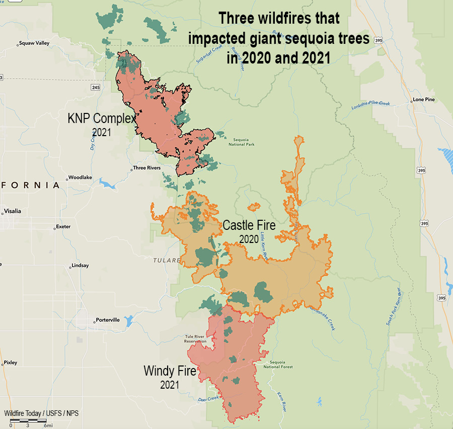
In a two year period 13 to 19 percent of all large sequoias in their natural range were killed by fires

If a sequoia is lucky, it can live for up to 3,000 years

burned Sequoia grove in Sequoia and Kings Canyon NP
Sequoia grove in Sequoia and Kings Canyon NP, November, 2021. NPS photo by Daniel Jeffcoach.

In 2020, 10 to 14 percent of the entire Sierra Nevada population of giant sequoia trees over 4 feet in diameter were killed in the Castle Fire. Early estimates expect that on two fires in 2021, the KNP Complex and the Windy Fire, 2,261 to 3,637 sequoias over four feet in diameter have already been killed or will die within the next three to five years. These losses make up an estimated additional 3-5% of the entire Sierra Nevada sequoia population over four feet in diameter.

In a two year period 13 to 19 percent of all giant sequoias in their natural range over four feet in diameter were killed or will die in the next few years.

These trees can live for up to 3,000 years. However, climate change, inadequate fuel management in the sequoia groves over previous decades, possible regeneration failure following the fires, and a shortage of firefighters while the blazes were burning have led to a significant threat to the persistence of the species.

Three Fires, giant sequoia trees
Three fires in two years that killed giant sequoia trees. The darker green areas represent groves of giant sequoias.

The burn severity in the 2021 fires was variable, from low severity which was beneficial, to high, which killed most of the trees and could make natural regeneration difficult or impossible. Areas that had been previously treated with prescribed fire or mechanical thinning reduced the mortality during the fires and allowed crews opportunities to safely fight fire more effectively.

Funds have been requested for the hundreds of acres, at least, that need to be replanted by hand.

Below is the “executive summary” of a report recently released about the effects of this year’s wildfires on the giant sequoia groves.


The 2021 fire season included two large wildfires (both started by the same lightning storm in early September) that burned into a large number of giant sequoia groves. This species has a limited distribution, covering just ~28,000 acres in ~70 groves on the western slopes of the Sierra Nevada mountains. Given the impacts of the 2020 Castle Fire to sequoia groves, where losses were estimated at 10-14% of the entire Sierra Nevada population of sequoia trees over 4 feet in diameter, there is significant concern by sequoia managers and the public regarding the impacts of these new fires. This report summarizes potential impacts to groves that were burned in the 2021 fire season, in the KNP Complex Fire and Windy Fire, including number of groves burned, amount of grove area burned at differing vegetation severity (RAVG-composite burn index), estimated number of large sequoias killed based on a preliminary analysis, the percentage of the entire population this loss represents, potential for regeneration failure, and potential for loss of seed source due to erosion (for KNP only). All of the data, data analysis, maps and modeling contained in this report are excerpted from the Burned Area Emergency Response Plan for the KNP Complex produced by an interagency team and submitted by the National Park Service. Some additional explanatory text and structure has been added to make this a standalone report. Because of this emphasis, there is more detail and analysis for KNP Complex sequoia groves than those burned in the Windy Fire.

Grove-level Estimates

  • In total 27 sequoia groves are fully or partially within the fire perimeters of the KNP Complex Fire and the Windy Fire.
    • 16 groves burned in the KNP Complex Fire.
    • 11 groves burned in the Windy Fire.
    • For both fires combined, 6,109 acres of giant sequoia groves were burned. This estimate is based on updated grove boundaries provided by the NPS and the USFS Region 5 Remote Sensing Laboratory.
      • KNP: 4,374 acres
      • Windy: at least 1,735 acres (Note: this estimate does not include two groves on the Tule River Reservation for which there is not publicly available spatial data)

Sequoia Grove Vegetation Burn Severity Analysis Using Composite Burn Index (CBI)

Fire severity was assessed using the USFS Rapid Assessment of Vegetation Condition after Wildfire (RAVG) four class Composite Burn Index product (CBI4) (details on the severity maps can be found on the RAVG website https://fsapps.nwcg.gov/ravg/). This analysis contains four categories of vegetation change: undetected change, low, moderate, and high, where high severity has been associated with 95% tree mortality (Miller et al., 2009). The acreage burned by severity class for each fire is:

KNP Complex (all ownerships):

  • Undetected change: 1,169 acres
  • Low: 1,849 acres
  • Moderate: 740 acres
  • High: 616 acres

Windy Fire (all ownerships):

  • Undetected change: 228 acres
  • Low: 659 acres
  • Moderate: 437 acres
  • High: 411 acres

Large Sequoia Mortality Estimates

For the KNP Complex we estimate that between 1,330-2,380 sequoias over four feet in diameter have already been killed or will die within the next three to five years. This estimate is based on RAVG satellite analysis combined with mortality rates from surveys in other sequoia groves that burned in three previous fires (similar methodology to Stephenson and Brigham 2021).

For the Windy Fire, we estimate that between 931-1,257 sequoias over four feet in diameter have already been killed or will die within the next three to five years.

The combined impact of these two fires is estimated to be 2,261-3,637 sequoias over four feet in diameter that have already been killed or will die within the next three to five years. These losses make up an estimated 3-5% of the entire Sierra Nevada sequoia population over four feet in diameter. On top of the 10-14% of large sequoias lost in the 2020 Castle fire, these fire impacts represent a significant threat to large sequoia persistence.

Dead sequoias killed fire
Dead sequoias, November, 2021. NPS photo.

Potential for Regeneration Failure

The least understood impacts of these wildfires are impacts to sequoia regeneration in high severity areas. Sequoias generally regenerate well after wildfire, though reports of inadequate regeneration in high severity areas are raising concerns. Regeneration failures could potentially occur if the cones and/or seeds were incinerated during crown fire, seeds did not survive the smoldering fire, or seeds washed away due to surface erosion. In these cases, regeneration would be dependent on proximity to live tree seed sources.

For the KNP complex we analyzed high severity areas within sequoia groves that were over 100 meters from an intact sequoia grove area with live sequoia trees (represented by areas of undetected change, low or moderate severity). In total 436 acres were identified that may be vulnerable to total sequoia loss if regeneration from seeds that survived the fire is inadequate. Of the 436 acres >100m from live sequoia forests, 335 acres are on NPS lands. The Burned Area Rehabilitation Plan recommends reforesting these 350 acres with giant sequoias if adequate regeneration is not present based on subsequent field surveys.

Erosion modeling suggests that the high severity areas identified for potential restoration are also at high risk of losing any seeds that did survive the fire due to surface erosion.

Other Key Points

In several places that burned during this event, previous prescribed fire work appears to have reduced fire severity (portions of Redwood Mountain Grove, Giant Forest). In other areas previous prescribed fire and mechanical thinning treatments, as well as preparation for upcoming burn units, allowed fire crews opportunities to safely fight fire more effectively (prescribed burn preparations at Lost Grove and Park Ridge Fire Lookout area were used during suppression operations on the KNP complex).

Although we are seeing some significant high and moderate severity areas in sequoia groves where we expect impacts to large giant sequoias to be detrimental, much of the grove area in the KNP Complex burned at low severity and we expect beneficial results for giant sequoias in these areas. These beneficial effects include fuel reduction, small canopy openings ideal for regeneration, and removal of litter and generation of ash – also ideal conditions for giant sequoia seedlings.

Other areas not classified as high severity may have also had beneficial effects, but the effects will likely be more mixed. In areas classified as “undetected change,” there will likely be a mix of completely unburned areas and areas that had a light surface fire that is similar to low severity fire effects. The fire effects in moderate severity will be the most variable, with some areas having beneficial effects and others being more severe.

Thanks and a tip of the hat go out to Ben.