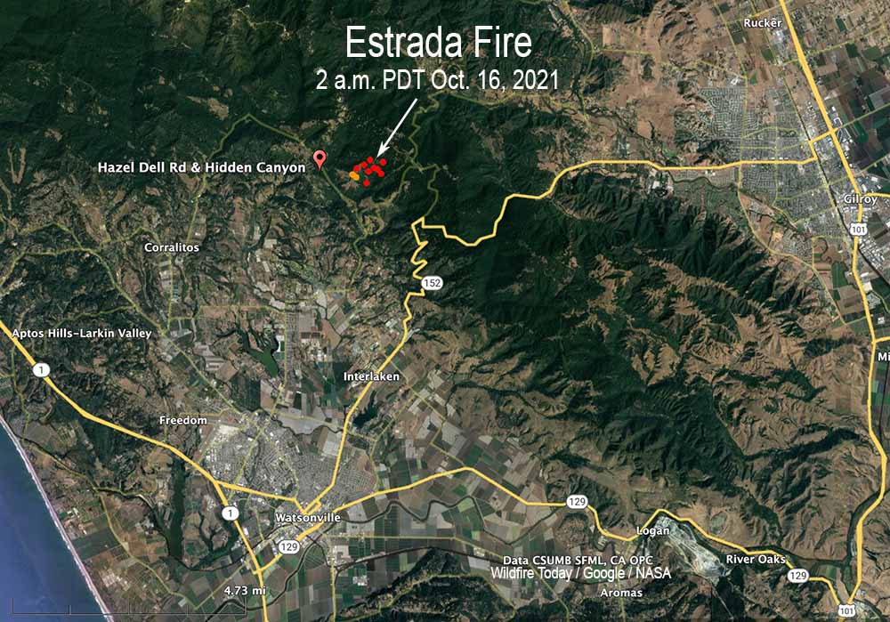
At 6:17 p.m. Saturday CAL FIRE revised the reported size of the Estrada Fire, increasing it from 83 acres to 148, saying the new number was the result of “accurate ground truthing and mapping.”
Firefighters will again work through the night Saturday to establish strong control lines.
11:09 a.m. PDT Oct. 16, 2021
Estrada Fire map. The red dots represent heat detected by a satellite at 2 a.m. PDT Oct. 16, 2021.
A prescribed fire intended to treat 20 acres grew out of control Friday, prompting evacuations in Central California.
The project was initiated by the California Department of Forestry and Fire Protection near the intersection of Hazel Dell and Hidden Canyon Road six miles northeast of Watsonville, California. After escaping the planned burn unit boundary it spread quickly, growing to 83 acres by Friday evening, when CAL FIRE said aircraft had established a line of fire retardant around the perimeter.
“Ninety-nine percent of the time these things go off without a hitch,” said Ian Larkin, CAL FIRE Chief for the San Mateo Santa Cruz unit. “No problems, they don’t get out of control, they don’t jump our containment line…The reason we did this yesterday was we had a prescription level of good weather, it was in prescription, and it was an ideal situation for us to be able to get good consumption of the fuel, and we just had this mishap. It was about 80 to 100 feet of tying it all in and we had a spot take off across the line.”
At 7:17 Saturday morning CAL FIRE said crews made significant progress overnight.
Estrada Fire, seen by the Mt. Madonna camera at 4:10 p.m. Oct. 15, 2021, looking southeast.
Evacuation orders were still in effect at 10:48 a.m. PDT October 16. (Evacuation map)
The video below, at 0:50, shows a fire whirl that is persistent, in spite of the water being applied from a fire hose.
The smoke will worsen Thursday afternoon and evening
Wildfire smoke forecast for 7 p.m. Oct. 14, 2021. NOAA.
Residents along the Southern California coast are seeing the effects of the Alisal Fire in the air they are breathing. On Thursday the South Coast Air Quality Management District issued a special air quality advisory for smoke that will be worsening during the afternoon.
Heavier concentrations of the smoke are expected to move into the counties of Orange, Riverside, San Bernardino, and L.A. Thursday afternoon and evening.
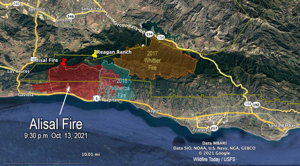
Alisal Fire vicinity map. The red line was the perimeter at 9:30 p.m. PDT Oct. 13, 2021. The white line was the perimeter about 24 hours earlier. Scroll down to see a more detailed map.
On Wednesday the Alisal Fire, 11 miles west of Goleta, California spread two miles further west and one mile to the east. On the east side it is still spreading through the five year old footprint of the Sherpa Fire.
Air tankers took advantage of decreasing winds Wednesday to apply retardant on the north side, reinforcing the West Camino Cielo road out to Gaviota on the west side. Crews conducted a firing operation along the road later in the afternoon.
Looking east at the Alisal Fire; retardant applied on the north side of the fire near West Camino Cielo road Oct. 13, 2021. Air Attack photo.
Additional evacuations were ordered Wednesday night for the area west of Arroyo Hondo to the intersection of Hwy. 101 and Hwy. 1, including Vista Del Mar School and Gaviota Beach. The ranch formerly owned by President Ronald Reagan, known as the Western White House, is also under evacuation orders. (More information about evacuations.)
To see all articles on Wildfire Today about the Alisal Fire, including the most recent, click HERE.
Thursday morning fire officials said the fire had burned 16,801 acres. Resources assigned to the fire Wednesday evening included 31 hand crews, 143 engines, and 8 helicopters for a total of 1,306 personnel, an increase of 541. Management of the fire has transitioned to a California Type 1 Incident Management team led by Jerry McGgowan.
Alisal Fire map. The red line was the perimeter at 9:30 p.m. PDT Oct. 13, 2021. The white line was the perimeter about 24 hours earlier. The red dots represent heat detected by a satellite at 1:48 a.m. PDT Oct. 14, 2021.
On Thursday firefighters are going to be faced with wind directions shifting about every six hours. Southwest winds are likely to develop in the morning, which may turn southeasterly in the early afternoon, before becoming northwesterly Wednesday evening. The relative humidity will be in the low 20s, but will rise to the mid-50s Wednesday night. Light and mostly onshore winds are in the forecast for Friday.
Alisal Fire, seen from Santa Ynez Peak, looking west-southwest at 7:04 a.m. PDT Oct. 14, 2021.Alisal Fire map, 3-D looking east. The red line was the perimeter at 9:30 p.m. PDT Oct. 13, 2021. The white line was the perimeter about 24 hours earlier.Alisal Fire map, 3-D looking west. The red line was the perimeter at 9:30 p.m. PDT Oct. 13, 2021. The white line was the perimeter about 24 hours earlier.
Below is a timelapse video of the Alisal Fire — about five hours compressed into 30 seconds. It was shot by the AlertWildfire camera on Santa Ynez Peak, looking west-southwest, from 2:20 p.m until 7 p.m., October 13, 2021.
Charred landscape at the Alisal Fire, off Refugio Road, Oct. 13, 2021
He was asked about the Tamarack Fire which was not aggressively attacked for 13 days
2:27 p.m. PDT Oct. 13, 2021
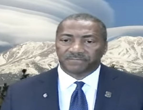
USFS Chief Randy Moore during Sept. 29, 2021 Congressional hearing.
In a Congressional committee hearing September 29 the new Chief of the U.S. Forest Service hit a lot of the right notes in his testimony. It was before the House of Representatives Agriculture Committee’s Subcommittee on Conservation and Forestry. The hearing was titled, “The 2021 Wildland Fire Year: Responding to and mitigating threats to communities.”
In his prepared statement, Chief Randy Moore, apparently standing in front of a real or virtual photo of Mt. Shasta topped by lenticular clouds, said “America’s forests are in a state of emergency and it’s time to treat them like one.”
He spoke for several minutes about issues related to the status of federal wildland firefighters. Here is an excerpt:
“We must maintain a stable resilient firefighting force. That starts with taking care of our brave men and women who fight fires.
“They deserve better work/life balance and benefits. They deserve a supportive workplace in return for the grueling hard work they do. At a time of increased stress, suicide, and depression they also need counseling and support services to prevent tragedy. They deserve better pay, above all. Federal wages for firefighters have not kept pace with states.
“We must also modernize our wildland fire management system. This includes improving the use of technology. It also includes upgrading our models and systems for decision making and strengthening our cooperative relationships.
“We will never hire enough firefighters, we will never buy enough engines or aircraft to fight these fires. We must actively treat forests. That’s what it takes to turn this situation around. We must shift from small scale treatments to strategic science-based treatments across boundaries. It must start with those places most critically at risk. We must treat 20 million acres over 10 years. Done right in the right places, treatments make a difference.”
Later the committee went on to talk more about firefighter pay, filling positions that are now occupied by detailers, aggressive forest management, timber harvesting, and other issues.
An interesting but very brief discussion occurred at 1:41:08 (see the video above) when Representative Doug LaMalfa of California’s 1st Congressional District (Oroville) asked the Chief about a report of difficulties in the working relationship between the Forest Service and CAL FIRE that surfaced during the Caldor Fire west of South Lake Tahoe according to 60 Minutes September 26, 2021.
“I think I have different information than you do, Congressman,” the Chief said. “I am not aware of any problems between the Forest Service and CAL FIRE. As I indicated earlier that relationship is really solid. So, I am not aware of anything that might be going on.”
Earlier Representative LaMalfa tried to get the Chief to say the Forest Service is committed to aggressive initial attack on new fires, but the Chief preferred to use the term “aggressive forest management.” (He later said that they already do aggressive initial attack.)
Representative LaMalfa asked about the Tamarack Fire near Markleeville, CA which started as a single tree on July 4, 2021 and was monitored but not suppressed for 13 days while it was very small until it suddenly grew very large. It burned at least 15 structures and more than 67,000 acres as it ran from California into Nevada jumping Highway 395 and prompting the evacuation of 2,000 people.
In the hearing Chief Moore said that after the fire started the Forest Service “spiked out a small crew to monitor” the fire. If that was the case, they apparently took no action, because the USFS reported on July 10 that it was 0.25 acre, they were not going to insert crews due to safety concerns, and it “posed no threat to the public, infrastructure, or resource values.”
In describing the situation, the Chief said that when the Tamarack Fire started on July 4 there were 100 large wildland fires and 27,000 fire personnel had been deployed. “We would have loved to have had enough crews to put on that fire,” the Chief said. “What we should be talking about is a very active forest management program. There will always be situations where you can second guess decisions that were made.”
The national Situation Report from July 5, 2021 shows that there were only 33 large uncontained fires at the time and 7,652 personnel had been mobilized. On July 22 the incident management team working on the Tamarack Fire reported that 1,200 personnel were assigned to the fire.
14,500 acres Wednesday morning, 12 miles west of Goleta, California
8:12 a.m. PDT Oct. 13, 2021
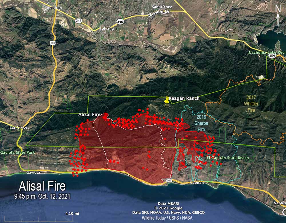
Alisal Fire map 9:45 p.m. Oct. 12, 2021. The red line was the perimeter at 9:45 p.m. PDT Oct. 12, 2021. The white line was the perimeter at 4:12 a.m. Oct. 12. The red dots represent heat detected by satellites at 2:56 a.m. PDT Oct. 13.
Wednesday morning the Santa Barbara County Fire Department said the Alisal Fire 12 miles northwest of Goleta, California has burned 14,500 acres, an increase of 1,100 acres over the figure released Tuesday evening. The growth over the last 24 hours has been on all sides, with the exception, of course, where the fire was stopped by the Pacific Ocean on the south.
The east side of the fire has burned into Sherpa Fire of 2016. During the 9:45 p.m. mapping flight Tuesday the strong winds and low fuel moisture helped it to spread two miles into the five-year-old footprint.
To see all articles on Wildfire Today about the Alisal Fire, including the most recent, click HERE.
Highway 101, the Pacific Railroad, and Amtrak lines remain closed and evacuations are still in effect. (More information about evacuations.)
On Wednesday fire officials expect to have working on the fire 5 air tankers, 6 helicopters, and a total of 1,300 personnel.
Alisal Fire map, 3-D, 9:45 p.m. Oct. 12, 2021. The red line was the perimeter at 9:45 p.m. PDT Oct. 12, 2021. The white line was the perimeter at 4:12 a.m. Oct. 12.
The spot weather forecast produced for the incident calls for 5-10 mph northeast winds Wednesday morning, becoming south to southwest at 5 to 10 mph by noon, then changing to come out of the northwest after 6 p.m. at 15 to 20 mph with gusts to 35. The humidity will be in the upper teens until it begins to rise in the afternoon. The standard NWS local forecast for the area is a little different.
Alisal Fire map, east side, 9:45 p.m. Oct. 12, 2021. The red line was the perimeter at 9:45 p.m. PDT Oct. 12, 2021. The white line was the perimeter at 4:12 a.m. Oct. 12. The red dots represent heat detected by satellites at 2:56 a.m. PDT Oct. 13.
Firefighters expect to have winds on Wednesday that will allow the use of fixed and rotor wing aircraft at least part of the day.
Firefighters on the Alisal Fire, Oct. 12, 2021. SBCFD photo.
7:09 p.m. PDT Oct. 12, 2021
Alisal Fire, seen from Santa Ynez Peak, looking southwest at 5:25 p.m. Oct. 12, 2021.
The wind slowed a bit late in the afternoon Tuesday, enough to allow fixed wing air tankers to work the Alisal Fire. At one point there were three over the fire and another four at the Santa Maria Airport 31 miles to the northwest. Helicopters have also been dropping water.
Most of the air tanker activity was on the west side, which corresponds with heat detected in that area by a satellite at 2:55 p.m. PDT. A weather station on Alisal Road recorded winds coming from the north-northwest, north, and north-northeast gusting around 20 mph hour between noon and 4:20 p.m. This could have caused more growth to the west.
The 2:55 p.m. satellite data showed significant growth on both the east and west sides Tuesday.
Fire officials said Tuesday evening the fire had burned 13,400 acres, almost double the last update.
KEYT reported that the Alisal Fire burned approximately 3,000 acres by 7:30 p.m.
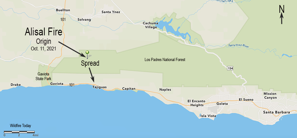
7:02 p.m. PDT Oct. 11, 2021
Map showing the origin location and initial spread of the Alisal Fire, October 11, 2021.
Within a few hours after it started at about 2:30 p.m. PDT Monday, very strong winds pushed the Alisal Fire three miles downhill from a ridgetop to the Pacific Ocean at Refugio State Beach west of Santa Barbara, California. Winds out of the north-northwest at 20 to 30 mph gusting to 50 drove it to Highway 101 by 5:30 p.m.
To see all articles on Wildfire Today about the Alisal Fire, including the most recent, click HERE.
Alisal Fire 3-D map, Oct. 11, 2021, looking north.
The wind was so strong that air tankers and even a mapping plane were unable to work on the fire during the initial hours.
Alisal Fire at Hwy. 101 at 5:43 p.m. Oct. 11, 2021. Via OurAirSBC
Monday afternoon the Alisal Fire was 25 miles west-northwest of Santa Barbara and 5 miles northeast of Gaviota.
Highway 101 is closed in the area and evacuations are in effect. An interactive evacuation map is available at https://arcg.is/1zO4m8. Enter your address at the top right field to determine if your area is under an Evacuation Order.
Alisal Fire, soon after it started. By Los Padres NF Air Attack. Oct. 11, 2021.
The relative humidity was surprisingly high Monday afternoon, ranging from 30 to 50 percent. The weather forecast for the fire area is for the wind to continue to be from the northwest until 10 p.m. Tuesday. The speed until 11 p.m. Monday is predicted to be 37 gusting to 49 mph, then decreasing at 2 a.m. Tuesday to 18 gusting to 24 until 10 p.m. Tuesday, after which it should drop to 5 mph out of the north. The relative humidity will peak at 71 percent at 8 p.m. Monday then steadily drop, reaching 19 percent by 2 p.m. Tuesday.
This predicted wind direction should cause the fire to spread more to the east than to the west.
Alisal Fire, looking southeast from the Refugio1 camera at 6:45 p.m. Oct. 11, 2021.Alisal Fire. Satellite photo at 5:17 p.m. PDT Oct. 11, 2021.