New Mexico: Signal fire northeast of Silver City

(UPDATED at 9:25 a.m. MDT, May 13, 2014)

Map of the Signal fire, 10 pm MDT, May 12, 2014
Map of the perimeter of the Signal fire, 10 p.m. MDT, May 12, 2014

The Signal Fire 12 miles north of Silver City, New Mexico is now is now estimated at 4,700 acres with no containment. Although fire activity on Monday was significantly less than on Sunday, the fire continued to spread to the north and east. Several air tankers, including a DC-10, supported firefighters on the ground by dropping numerous loads of retardant on the perimeter of the fire.

A Southwest Area Type 2 Incident Management Team assumed command of the fire Monday.

****

(Originally published at 2:31 p.m. CDT, May 12, 2014; updated at 7:30 p.m. CDT, May 12, 2014 with a new map)

Firefighters are battling a new wildfire, the Silver Fire, 12 miles north of Silver City, New Mexico on the Gila National Forest. It started May 11 and has grown to about 3,000 acres with no containment. Sunday, the fire exhibited rapid fire spread and torching with spotting up to ¼ mile. The fire is burning in timber with a grass understory. 

A Type 2 Incident Management Team is en route and is expected to assume command at 6 p.m. Monday.
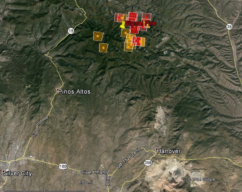
Map Signal Fire
Map of the Signal Fire, showing heat detected by a satellite at 2:57 p.m. MDT, May 12, 2014. The location of the icons can be as much as a mile in error.

Resources assigned to the fire include:

  • Crews: 1 Hotshot Crew and an unknown number of smokejumpers;
  • 3 Engines
  • Aircraft:
    • 8 air tankers: including one very large air tanker, 3 Type 2 air tankers, and 4 Single Engine Air Tankers;
    • 5 helicopters
    • 3 air attack, 1 Aerial Supervision Module, and 1 lead plane

Residents in the vicinity of Signal Peak have evacuated. Highway 15 has been closed from the Ben Lilly Monument north to the Gravel Pit near Wildhorse Mesa. Firefighters are employing full suppression tactics to contain and extinguish the fire.

The weather forecast for the fire area on Monday calls for 56 degrees, winds of 15 mph gusting to 23, and a relative humidity of 16 percent. Tuesday should be much cooler, more humid, with decreasing winds. The nearest Remote Automatic Weather Station is the Gila Center RAWS, 20 miles to the north.

Wildfire in Texas destroys 75 homes

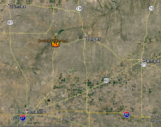
Map Double Diamond Fire
Map showing the location of the Double Diamond Fire in the panhandle of Texas.

(Updated at 11:10 a.m. CDT, May 13, 2014)

Firefighters have stopped the spread of the Double Diamond Fire near Fritch, Texas and are mopping up the remaining hot spots. A more accurate assessment of the damage revealed that the fire destroyed 156 structures, at least 89 of which were homes, Texas Forest Service spokesman Troy Duchneaux said late Monday.

****

(Originally published at 11:04 a.m. CDT, May 12, 2014)

The Double Diamond wildfire in the Texas panhandle has destroyed about 75 homes 30 miles northeast of Amarillo, but as of Monday morning the fire is 75 percent contained, according to Fritch chief of police Monte Leggett. The fire, approximately 1,200 acres in size, forced hundreds of the town’s residents to evacuate.

At the time the fire was reported at 5 p.m. Sunday, a weather station four miles northeast of the fire recorded winds of 20 mph gusting up to 39 mph, a temperature of 96 degrees, and a relative humidity of 7 percent, conditions very conducive to rapid fire spread. Today at 10:35 a.m. CDT, weather conditions have moderated significantly in favor of the firefighters — 51 degrees, wind of 16 mph gusting to 25, and a relative humidity of 52 percent.

Research: Firewise principles may not reduce suppression costs

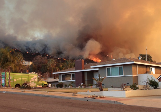
Home threatened by the Colby fire east of Los Angeles, January 17, 2014.  Photo by John Stimson.
Home threatened by the Colby fire east of Los Angeles, January 17, 2014. Photo by John Stimson.

A study conducted by Headwaters Economics explored how firefighting costs might be affected by the application of Firewise principles in a community. To achieve official status as a Firewise Community, it must get a written wildfire risk assessment from their state forestry agency or fire department. Second, communities are required to generate an action plan and form a board or committee based on their risk assessment. Next, they must organize and hold a public education “Firewise Day” event. The final step before applying requires that they invest at least $2 per person in annual Firewise actions.

But those requirements do not guarantee that a large percentage of homeowners will actually take steps to create defensible space or use fire resistant building materials on their structures. There is also no requirement that a community construct a large-scale fuelbreak that would reduce the intensity of an approaching wildfire and the accompanying ember shower that is the culprit for igniting most homes during a fire seige.

The study analyzed costs of 111 fires. Their conclusion was:

We find no evidence of a relationship between suppression costs and Firewise participation represented by: (1) the percent of homes in Firewise Communities for the area within 6 mi. (9.7 km) of wildfires, and (2) the Firewise-related expenditures by residents. The lack of evidence that Firewise reduces suppression costs suggests that policy makers attempting to address rising suppression costs are better served focusing on other solutions, including increasing suppression funding and managing future development in high-risk areas.

The Firewise program is not designed to reduce the costs of fire suppression. Its goals are to reduce the deaths of residents, protect private property from fire, and enhance the safety of firefighters and the general population.

During the course of the study the researchers interviewed 16 Type 1 and 2 Incident Commanders. Some of them stated that the patchwork nature of the creation of defensible space and the use of fire resistant building materials at the parcel level within a Firewise Community made it difficult to modify fire suppression tactics and strategy based on an official community-wide designation .

Santa Ana winds predicted for southern California

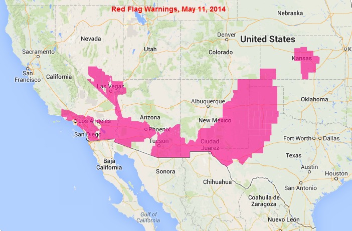
wildfire Red Flag Warnings, May 11, 2014

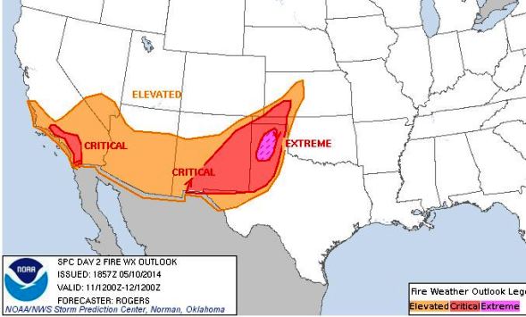
Extreme fire weather is predicted for southern California and the panhandle of Texas for Sunday.

Extreme fire weather
Extreme fire weather prediction for Sunday morning through Monday morning

A Red Flag Warning is in the forecast beginning Monday morning for southern California. The National Weather Service released this at 4:44 p.m. PDT, Sunday, May 10. The emphasis is added.

ORANGE COUNTY COASTAL AREAS-
SAN BERNARDINO AND RIVERSIDE COUNTY VALLEYS-THE INLAND EMPIRE-
SAN BERNARDINO COUNTY MOUNTAINS-
INCLUDING THE MOUNTAIN TOP AND FRONT COUNTRY RANGER DISTRICTS OF
THE SAN BERNARDINO NATIONAL FOREST-SANTA ANA MOUNTAINS-
INCLUDING THE TRABUCO RANGER DISTRICT OF THE CLEVELAND NATIONAL
FOREST-
444 PM PDT SAT MAY 10 2014

..RED FLAG WARNING REMAINS IN EFFECT FROM 6 AM SUNDAY TO 8 PM
PDT TUESDAY FOR STRONG GUSTY WINDS AND LOW HUMIDITIES

A RED FLAG WARNING REMAINS IN EFFECT FROM 6 AM SUNDAY TO 8 PM PDT
TUESDAY.

* WINDS..NORTHEAST WINDS 20 TO 35 MPH…WITH GUSTS TO 70 MPH
NEAR COASTAL FOOTHILLS AND BELOW PASSES AND CANYONS. THESE
WINDS WILL SLIGHTLY WEAKEN LATE SUNDAY NIGHT AND MONDAY…THEN
INCREASE AGAIN ON MONDAY NIGHT AND INTO TUESDAY.

* RELATIVE HUMIDITY…LOWEST DAYTIME AROUND 5 PERCENT…WITH
POOR OVERNIGHT RECOVERY.

* TIMING…THE FIRST ROUND OF WINDS WILL OCCUR SUNDAY MORNING. A
SECOND ROUND OF WINDS WILL OCCUR FOR LATE SUNDAY NIGHT THROUGH
EARLY MONDAY AFTERNOON…WITH A THIRD ROUND OF WINDS LATE
MONDAY NIGHT THROUGH EARLY TUESDAY AFTERNOON.

* OUTLOOK…VERY DRY CONDITIONS WILL CONTINUE THROUGH AT LEAST
THURSDAY. LOCALLY GUSTY OFFSHORE WINDS WILL BE POSSIBLE ON
WEDNESDAY AND THURSDAY…BUT MAY NOT BE AS STRONG AS ON SUNDAY
OR TUESDAY.

****

UPDATE Sunday morning, May 11, 2014:

California: report concludes BLM officer’s vehicle likely cause of Chariot Fire

CAL FIRE report about the Chariot Fire
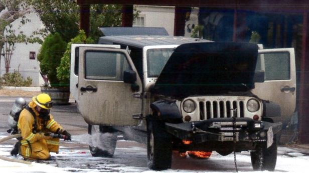
Photo from CAL FIRE report about the Chariot Fire. CAL FIRE photo.

A report released Thursday by CAL FIRE about the Chariot Fire concluded that the most likely cause of the fire was a vehicle driven by a Bureau of Land Management officer.

The fire started July 6, 2013 40 miles east of San Diego near the Butterfield Ranch in the Anza-Borrego Desert, 3,000 vertical feet below the community of Mt. Laguna. Managed by CAL FIRE, it burned into the Cleveland National Forest not far from the Mt. Laguna Engine Station. The fire blackened 7,000 acres and destroyed 149 structures — most of those were at the Al Bahr Shrine Camp.

Below is an excerpt from an article at U-T San Diego:

…The state report says the fire probably started when brush got caught in the undercarriage of a Jeep driven by BLM field Officer Jason Peters as he drove along the desert floor. It mentions another possibility — that a pickup truck spotted in the area that afternoon may have been the cause — but says no additional evidence was found to support that theory.

Peters — who initially said he didn’t arrive on the scene until after the blaze began — has refused to cooperate with investigators since the early days of the investigation, the report said.

The BLM conducted its own investigation into the incident, but is refusing to release the results. A BLM spokeswoman late Thursday night said Peters is still a BLM employee who works out of the El Centro Field office.

The 318-page Cal Fire report, prepared by Capt. Kelly Gallaher, said the agency explored all possible causes of the fire, and eliminated all but two. A couple witnesses saw a pickup truck in the desert that day, but no further information could be developed about the truck or its occupant and no evidence was found indicating it was responsible.

The report suggests the more likely scenario is that “the fire originated from the vehicle driven by Jason Peters going through tall brush, either dropping burning brush into a receptive fuel bed, or a potential failed fuel line spreading fire on a receptive fuel bed.”
The document describes Peters under a section titled “suspect.”

The report details how Peters Jeep caught on fire in the parking lot of the Butterfield Ranch Campground the afternoon of July 6. Peters’ initial incident report is included in the Cal Fire report. In it, he says he saw smoke in the distance and went to investigate, at times driving over heavy brush. He then drove to the Butterfield Ranch store, parked his Jeep and went inside leaving the vehicle idling. When he came back outside his Jeep was on fire.

Wildfire briefing, May 8, 2014

Train ignites multiple fires in five cities

A freight train spraying sparks along railroad tracks in southern Maine started multiple wildfires in five cities on Thursday. Firefighters responded from 20 communities to the five alarm incident to battle fires in South Portland, Scarborough, Old Orchard Beach, Saco, and Biddeford. The worst hit area was the Wagon Wheel RV Resort and Campground, at 3 Old Orchard Beach Road. Firefighters said 10 campers were destroyed and another six were damaged.

Veterans hired as firefighters in New Mexico

A state-funded program in New Mexico called “Returning Heroes” is putting 46 veterans to work as wildland firefighters. More information can be found at KOAT.

Rain on the fires in Oklahoma

About an inch of rain Wednesday night is helping firefighters in Oklahoma suppress and mop up the fires near Guthrie and Woodward.

Air tanker arrives early at Santa Maria

A DC-10 and other firefighting aircraft are stationed at the Santa Maria airport in California about a month earlier than normal. A spokesman for the U.S. Forest Service said the planes were brought to Santa Maria early because of recent red flag warnings for extreme fire danger in the area.

Prose in a Police Log

The Police Log published in the Georgetown Record in Massachusetts does not waste any words. An entry about a vegetation fire on April 25, for example:

9:48 p.m. Services were rendered for a brush fire on Nelson Street.

Other services “rendered” included “a utility emergency on East Main Street”, “a disabled motor vehicle on Andover Street”, and “an animal complaint on Central Street”.

It takes years of experience and training to write an official report in the style of a firefighter or police officer.