Wildfire potential, May through August, 2014

Posted on Categories UncategorizedTags ,

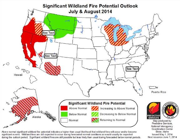
The Predictive Services section at the National Interagency Fire Center has issued their Wildland Fire Potential Outlook for May through August, 2014.

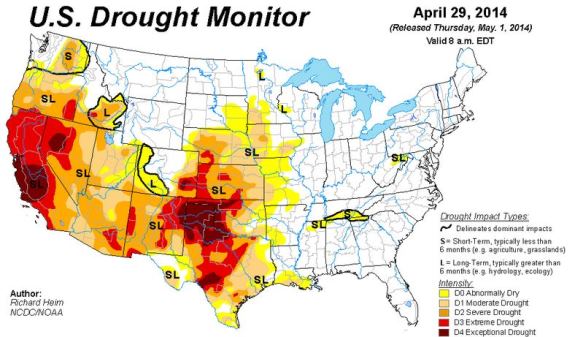
And below that is the latest edition of the Drought Monitor, released today.

****

“The May, June, and July through August 2014 significant wildland fire potential forecasts included in this outlook represent the cumulative forecasts of the eleven Geographic Area Predictive Services Units and the National Predictive Services Unit.

May
– Above normal fire potential will be over much of California, southern Arizona, and southwestern New Mexico. Must of southern Alaska will have above normal fire potential.
– Below normal fire potential will continue for most of the Ohio, Tennessee, and lower Mississippi Valleys, the central Gulf Coast; eastern Texas and eastern Oklahoma.

May 2014 wildfire outlook

June
– Above normal fire potential will expand to include northern California, Nevada, and much of Oregon. Most of Alaska will continue to see above normal significant fire potential.
– Below normal fire potential will continue over the lower and mid-Mississippi, Tennessee and Ohio Valleys.
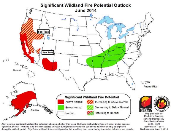
June 2014 wildfire outlook
July through August
– Above normal fire potential will remain in most of California, northern Nevada, and central Oregon. Above normal fire potential will expand into eastern Oregon, southwestern Idaho, and the Great Lakes region.
– Southeastern Arizona, southwestern New Mexico and Alaska will return to normal fire potential.
– Below normal fire potential will cover most of the northern Rockies.”

July-August 2014 wildfire outlook****

Drought monitor May 1, 2014


California: Etiwanda Fire ignites during wind event

Map of Etiwanda Fire
Map of the Etiwanda Fire, May 2, 2014. Provided by the Incident Management Team.

(UPDATE at 1:55 p.m. MDT, May 2, 2014)

The Incident Management Team is reporting good progress on the Etiwanda fire east of Los Angeles. Better mapping shows that the fire has burned 2,190 acres and the Team is calling it 53 percent contained. The perimeter held successfully overnight. A small flare up occurred near the Smith drainage but was quickly put out. 

The map of the Etiwanda Fire, above, was updated today, May 2.

All mandatory and voluntary evacuations have been lifted and all schools were in session on Friday.

****

(UPDATE at 7:55 p.m. PDT, May 1, 2014)

The Incident Management Team is reporting that the Etiwanda Fire east of Los Angeles has been mapped at 1,627 acres, and they are calling it 53 percent contained; 929 firefighters & support personnel are assigned.

****

(Originally published at 9:50 a.m. May 1, 2014)

The first report of the Etiwanda Fire north of Ranch Cucamonga, California came in at 8:08 Wednesday morning while Santa Ana winds were gusting at 60 to 80 mph. One gust during the day was recorded at 101 mph which qualifies as category 2 hurricane strength. Mandatory evacuations were ordered for 1,650 homes but were cancelled at 5;30 p.m. Voluntary Evacuations are still in effect for Thursday morning for residents north of Hillside Road between Haven Avenue and Milliken Avenue.

Incident Commander Norm Walker is calling the fire 1,000 acres and 10 percent contained.

Today a Red Flag warning continues to be in effect with forecasters expecting northeast winds of 25 to 35 mph with gusts of 40 to 65 mph. The winds will moderate by late afternoon, decreasing to less than 10 mph.The relative humidity will bottom out at 5 percent today and will remain below 20 percent until Friday night. 

The strong winds on Wednesday made it unsafe and impractical for helicopters and fixed wing air tankers to assist firefighters on the ground. Even if they could have safely navigated 150 feet above the rugged terrain in the gusty conditions, the wind would have blown the retardant or water far away from the targets. Strong winds again on Thursday will most likely prevent aerial resources from working the fire, at least until late afternoon when conditions are expected to settle down.

On Tuesday, in spite of a weather forecast for the day of wind gusts exceeding 80 mph, single-digit humidities, and record 95 degree heat, the National Weather Service did not declare a Red Flag Warning until 9:35 Tuesday morning.


Red Flag Warnings, May 1, 2014

wildfire Red Flag Warnings, May 1, 2014

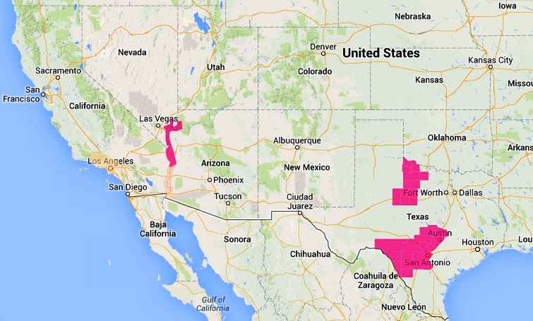
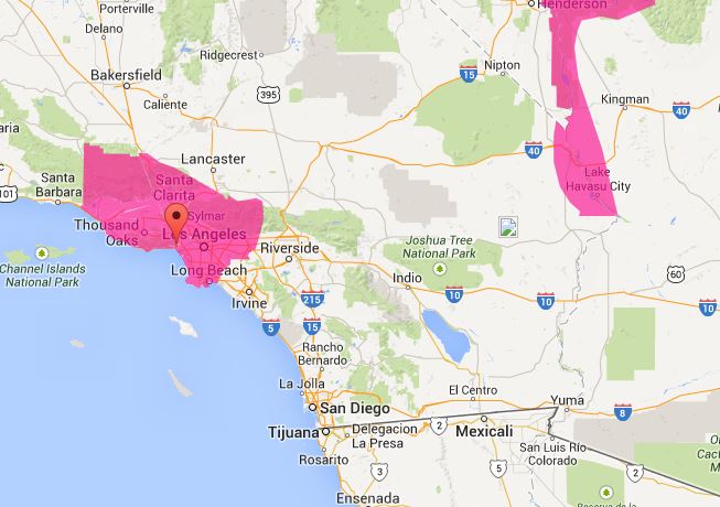
Warnings for elevated wildfire danger have been issued by the National Weather Service for areas in southern California and Arizona.

In Southern California forecasters expect northeast winds of 25 to 35 mph with gusts of 40 to 65 mph. Relative humidity will bottom out at 5 percent.

The Red Flag Warning map was current as of 9:25 a.m. MDT on Thursday. Red Flag Warnings can change throughout the day as the National Weather Service offices around the country update and revise their forecasts. For the most current data, visit this NWS site.

Florida: prescribed fire escapes at St. Johns National Wildlife Refuge

Saint Johns National Wildlife Refuge, map

A prescribed fire escaped at a national wildlife refuge east of Orlando on Monday. The plan was to burn 660 acres within St. Johns National Wildlife Refuge, but multiple simultaneous spot fires outside the burn unit exceeded the capability of the firefighters from Merritt Island National Wildlife Refuge who were conducting the burn. An additional 72 acres of private land and 200 acres of Brevard County property outside the refuge burned — 600 acres in the original planned unit were completed.

The escape was knocked down by 43 personnel on Monday. Today spokesperson Candice Stevenson of the U.S. Fish and Wildlife Service said the fire is 70 percent contained. Agencies involved in the suppression of the escaped fire included the U.S. Fish and Wildlife Service, Brevard County, Florida Forest Service, the City of Titusville, and the U.S. Forest Service.


80 mph wind gusts predicted for SoCal

UPDATED at 5:30 p.m. PDT, April 29, 2014:

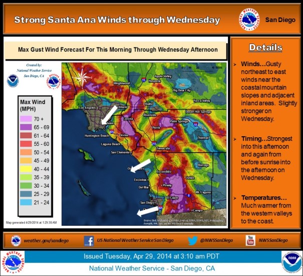
We have updated information from the National Weather Service about the wind event in southern California that is now predicted to last into Thursday.

1:14 PM PDT TUE APR 29 2014

RED FLAG WARNING FOR LATE TONIGHT INTO THURSDAY EVENING…

A RIDGE OF HIGH PRESSURE OVER THE WEST COAST COMBINED WITH OFFSHORE FLOW FROM SURFACE HIGH PRESSURE OVER THE GREAT BASIN WILL BRING MUCH HIGHER TEMPERATURES AND VERY LOW HUMIDITIES WITH POOR OVERNIGHT RECOVERIES THROUGH THURSDAY. THE OFFSHORE FLOW WILL ALSO BRING PERIODS OF STRONG AND GUSTY NORTHEAST WINDS NEAR THE COASTAL MOUNTAIN SLOPES AND ADJACENT INLAND AREAS…WITH STRONGEST GUSTS TO AROUND 85 MPH WEDNESDAY MORNING. MODERATE STRENGTH AND LESS WIDESPREAD NORTHEAST WINDS WILL CONTINUE INTO THURSDAY WITH EVEN WEAKER WINDS INTO FRIDAY.

NWS graphic 4-29-2014
****

(Originally published at 8:30 a.m. PDT, April 29, 2014. Updated at 10:30 a.m. PDT, April 29, 2014 to add a new Red Flag Warning issued at 9:35 a.m. MDT.)

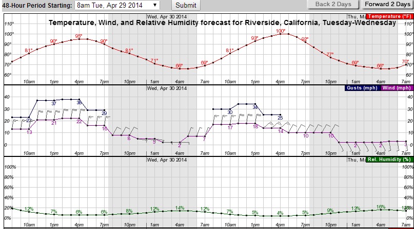
Riverside, CA fire weather forecast
Riverside, CA weather forecast for Tuesday and Wednesday. (click to enlarge)

Wind gusts exceeding 80 mph and single-digit humidities are in the forecast for some areas of southern California Tuesday and Wednesday. A High Wind Warning issued by the National Weather Service at 1:55 a.m. Tuesday predicted sustained winds of 25 to 40 mph with gusts to 80 today, increasing on Wednesday to 30 to 45 mph with gusts to 85. That forecast applies to Orange County coastal areas, San Bernardino and Riverside county valleys, the Inland Empire, San Diego County valleys, and the mountain areas in the counties of San Bernardino, Riverside, and San Diego.

The graphical forecast (above) for Riverside shows relative humidities as low as 6 and 4 percent today and Wednesday, respectively, and high temperatures of 95 and 100.

In spite of this forecast, and live fuel moistures that are typical of July, there is no Red Flag Warning in effect for the area, only a Fire Weather Watch for portions of Los Angeles and Ventura Counties. UPDATE at 10:18 a.m. PDT Tuesday: the NWS issued a Red Flag Warning for portions of Los Angeles and Ventura Counties at 9:35 a.m. PDT

In anticipation of this wind event, CAL FIRE has moved engines and hand crews to the southern part of the state. Air tanker and helitack bases in the area were ordered to be ready to fly at 7 a.m.

wildfire Red Flag Warning -- April 29, 2014
Red Flag Warnings (in red) and Fire Weather Watches (in yellow) areas —  8:30 a.m. PDT April 29, 2014

The Red Flag map above was current at 8:30 a.m. PDT, April 29. The revised map below was captured at 10:23 a.m. PDT, April 29, showing all of the Fire Weather Watches had been cancelled, and Red Flag Warning issued for portions of Los Angeles and Ventura Counties.

Red Flag Warnings
Red Flag Warnings in southern California — 10:23 a.m. PDT, April 29, 2014

Near-real-time wind speeds in southern California can be monitored at this NOAA website.

Red Flag Warnings can change throughout the day as the National Weather Service offices around the country update and revise their forecasts. For the most current data, visit this NWS site.

Weather radar detects wildfire smoke in Texas

The San Anglelo, Texas office of the National Weather Service published some interesting messages yesterday on Twitter.

To see the most current smoke reports on Wildfire Today, visit the articles tagged “smoke” at https://wildfiretoday.com/tag/smoke/