Arizona: Type 1 Team ordered for Brown Fire

Brown Fire, April 13, 2014. US Forest Service Photo.

(UPDATED at 2:18 p.m. Ariz. time, April 17, 2014)

The incident management team on the Brown Fire in southern Arizona is listing the fire at 240 acres; 232 of the acres are on U.S. Army Fort Huachuca, and 8 acres are on the Coronado National Forest. That is a 34 percent reduction in size as a result of a more accurate map produced after a fixed wing infrared mapping flight Wednesday night.

Fire crews have been working on the fire since Monday constructing fire line, but Clay Templin’s incident management team continues to say there is zero percent containment after four days of work.

Below is a description of Wednesday’s activity on the fire:

Low humidities and gusty erratic winds occurred on the fire area. Low fire behavior with some areas of creeping and smoldering fire were observed. Firefighters made progress building direct fireline on the east and west flanks of the fire however containment will not occur until firefighters are confident the lines will hold. The forward spread of the fire has been stopped. Use of retardant and water from the helicopter was effective in assisting ground forces. Contingency line preparation continued in Sawmill Canyon to the west of the fire and Ramsey Canyon to the east of the fire. Firefighters conducted structural assessments in the Ramsey Canyon area.

This will be our last report on the Brown Fire unless it increases substantially in size.

****

(UPDATED at 12:05 p.m. Ariz. time, April 16, 2014)

The size of the Brown fire in southern Arizona is still reported to be 366 acres, the same as on Monday. Clay Templin’s incident management team continues to say there is zero percent containment, implying that no fireline has been constructed and held. Below is an update from the team at 8 a.m. Wednesday, describing the activities on Tuesday:

Three hotshot crews anchored the fire and began constructing fireline on the southeast and southwest flanks of the fire. Firefighters also scouted contingency lines. Airtankers and helicopters continued to drop retardant and water on the fire to try to minimize the fire’s spread. Aircraft began utilizing the tanker base at Libby Field with the exception of the DC-10 VLAT which is based out of Phoenix-Mesa Gateway Airport. Clay Templin’s Type 1 Southwest Incident Management Team assumed command of the fire Tuesday at 6pm.

****

(UPDATED at 2:52 p.m. Ariz. time, April 15, 2014)

A satellite pass over the Brown Fire in southern Arizona at 11:40 a.m. Ariz. time today did not detect any large hot areas on the fire, nor have any been found by the satellite during other passes since the flyover at 10:48 a.m. Ariz. time, April 14. Current images from a weather satellite do not show a large smoke plume. This tends to indicate that the fire has not been very active today. However, that could change.

An update issued by the Incident Management Team at 11:50 a.m. today still listed the fire size at 366 acres with no containment, the same as on Monday. The growth potential was described as “moderate” and the fire behavior as “Active fire. Short runs. Isolated torching with short range spotting”. No structures are threatened, and the terrain is described as the proverbial “steep, rugged, and inaccessible”.

Another Fire Weather Watch is in the forecast again for Wednesday due to low humidity, strong winds, and continued drought conditions.

A public meeting will be held Tuesday at 7 p.m. at the Sierra Vista Ranger District office, 4070 S. Avenida Saracino, Hereford, AZ

****

(Originally published at 10:54 a.m. Ariz. time, April 15, 2014)

A Type 1 Incident Management Team has been ordered for the Brown Fire burning in Garden Canyon on the north side of the Huachuca Mountains in southern Arizona. As you can see on the map of the fire below, it is burning seven miles north of the Mexican border and eight miles southwest of Sierra Vista, Arizona.

Brown Fire 10:48 a.m. AZ time, April 14, 2014
Map showing the location of the Brown Fire. Heat was detected by the MODIS satellite at 10:48 a.m. AZ time, April 14, 2014. The fire has grown since then. (click to enlarge)

At 9 p.m. on April 14 the Brown Fire was reported to be 366 acres with no containment, a little small for a typical Type 1 Incident Management Team (IMT) assignment, but apparently the managers of the Coronado National Forest believe the fire has the potential to become large and complex. It started on Fort Huachuca, a U.S. Army base, on April 13 and burned onto the Forest Monday morning. The fire is human-caused.

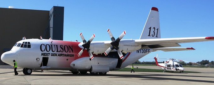
Helicopters and air tankers, including a DC-10, have been dropping water and retardant on the fire.

The area is under a Fire Weather Watch today for low relative humidity, drought conditions, and strong winds.

The IMT ordered was Clay Templin’s Type 1 Southwest team. They are scheduled to assume command at 6 p.m. on Tuesday.

Today firefighters expect to scout for handline construction contingencies, use helicopters for crew shuttles, and continue to use helicopters and air tankers to drop water and retardant.

As of 9 p.m. Monday, firefighting resources assigned or en route include 160 personnel:

  • 2 hotshot crews on scene – Ironwood IHC & Silver City IHC (3 additional hotshot crews enroute)
  • Coronado NF crew 5 short crew
  • 2 Single Engine Air Tankers (SEATs)
  • 2 P2V air tankers
  • 1 Very Large Air Tanker (VLAT)
  • 1 Type 3 helicopter
  • 1 Type 2 helicopter
  • (1 one Type 1 helicopter enroute)
  • Miscellaneous fire engines (crews supporting suppression efforts)
  • Miscellaneous overhead

More winners announced for Lead By Example Award

Two weeks ago the National Park Service announced that two of their wildland fire personnel received Paul Gleason Lead By Example Awards for 2013 — Chad Fisher, wildland fire safety program manager, and Jim Shultz, wildland fire training program manager.

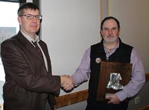
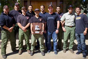
Today the National Interagency Fire Center distributed a news release stating that two other Lead By Example awards were also issued. Below is the text of the release (we added the photos of Mr. Seilstad and the Palomar Hotshots; photos of Mr. Fisher and Mr. Shultz are in the previous announcement).

****

Lead by Example Award Winners for 2013

Boise, Idaho – The National Wildfire Coordinating Group Leadership Subcommittee announced that Chad Fisher, Dr. Carl Seielstad, Jim Shultz and the Palomar Interagency Hotshot Crew were selected for the 2013 Paul Gleason Lead by Example Award. The recipients were nominated for demonstrating valued leadership traits during or in support of wildland fire operations.

The Lead by Example Award is based on three categories: motivation and vision; mentoring and teamwork; and innovation or initiative. Individuals and groups from federal, state, local and tribal agencies are eligible for the award.

The annual award was created to honor Paul Gleason, a wildland firefighter whose career spanned several decades. Gleason is best known for developing the LCES (Lookout, Communication, Escape Routes, Safety Zones) concept that became the foundation of wildland firefighter safety. The awards highlight Gleason’s influence on and contribution to wildland fire management, while honoring those who demonstrate the spirit of leadership for which he was known.

Award Recipients for 2013

Chad Fisher, National Park Service, National Interagency Fire Center, was selected for his motivation and vision work with the Dutch Creek mitigations which resulted in a change in firefighter safety regardless of size or complexity. Fisher’s dedication to ensure safety across agency boundaries has resulted in a shift in culture regarding incident-within-an-incident planning.

Carl Seielstad 2013
Dr. Carl Seielstad

Dr. Carl Seielstad, College of Forestry and Conservation, University of Montana, was selected for his initiative and innovation by establishing the Wildland Fire Program and Prescribed Fire Practicum in partnership with the Nature Conservancy, which provides students with hands-on leadership and prescribed fire experiences. Seielstad’s visionary leadership offers students a unique opportunity while providing a background to become highly effective fire managers.

Jim Shultz, National Park Service, National Interagency Fire Center, was selected for mentoring and teamwork across agency boundaries through programs like the Fire and Aviation Mentoring program and National Interagency Joint Apprentice Committee. Shultz’s leadership skills and calm demeanor also helped ensure that all honor guards worked together during the Granite Mountain Hotshot Memorial Service

Palomar Hotshots 2013
Palomar Hotshots

The Palomar Interagency Hotshot Crew, Palomar Ranger District/Cleveland National Forest, US Forest Service, was selected for demonstrating initiative and innovation through efforts like their crew website and 2012 “Leadership is Action” video. Palomar Hotshots continue to provide leadership development through non-traditional leadership styles and allow individuals to strive for a higher performance level as a leader.”

Fire in Chile burns hundreds of homes

Chile fire
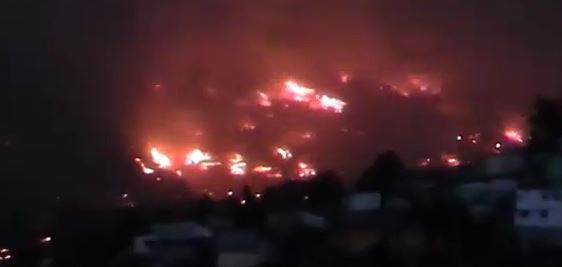
The fire in Valparaiso, Chile burns structures. Credit: GlobalLeaks.

(Originally published at 12:40 a.m. MDT, April 13, 2014)

UPDATED at 4:23 p.m. MDT, April 14, 2014)

In this video Nick Wiltgen of the Weather Channel explains how winds and geography are affecting the fire.

Below, are before and after photos of a portion of the fire area at Valparaiso.

(UPDATED at 11:25 a.m. MDT, April 14, 2014)

Continued strong winds are preventing firefighters from gaining control of the fire in Valparaiso, Chile. The latest information is that at least 12 people have been killed, 500 injured, and about 2,000 homes have burned.

Some of the communities affected do not have municipal water infrastructure or fire hydrants, and the streets are too narrow for fire engines.

“We are too vulnerable as a city. We have been the builders and architects of our own danger,” Valparaiso Mayor Jorge Castro said Sunday in an interview with Chile’s 24H channel.

NPR’s Lourdes Garcia-Navarro reported:

To contain the blaze, some 20 helicopters have been dumping water on the fires. But in some areas, fire crews have been able to do little other than watch buildings burn and hope the flames don’t spread farther.

The blaze began on Saturday in a forested ravine and has spread quickly — destroying whole areas and pushed on by hot winds. Schools in the city are closed today as many are overflowing with evacuees.

From latino.foxnews.com:

It was already the city’s worst fire since 1953, when 50 people were killed. [President Michelle] Bachelet declared the entire city a catastrophe zone and put the military in charge of maintaining order. Some 1,250 firefighters, police and forest rangers battled the blaze while 2,000 sailors in combat gear patrolled streets to maintain order and prevent looting.

Chile’s emergency response system generated automatic phone calls to each house in danger as the mandatory evacuations expanded. Many people stuffed their cars with possessions after getting these calls, and streets quickly became impassible. Water trucks and firefighters were stuck downhill as people abandoned their vehicles and ran. Some carried television sets and others took canisters of natural gas, fearing an explosion if flames reached their homes.

(UPDATED at 9:35 a.m. MDT, April 13, 2014)

Incredible photos of the fire are on the Daily Mail website.

The Guardian reports that seven people have died in the fire in Chile, 500 homes have been destroyed, and 5,000 residents evacuated. CNN’s article said 11 have died, 500 homes have burned, and 3,000 people evacuated in front of the 2,000-acre fire. You can see live reports about the fire on CNN Chile.

****

A vegetation fire in Chile has burned hundreds of homes and forced thousands of residents to evacuate. Reports on the number of destroyed structures in the city of Valparaiso vary from 150 to 500. CNN reports that a prison in the city that houses 2,000 inmates will be evacuated.

President Michelle Bachelet declared Valparaiso to be a catstrophe zone, which allows the military to maintain order and handle the evacuations.

Strong winds are pushing the fire and hampering the efforts of the 500 firefighters from seven provinces that are fighting the blaze.


Thanks and a hat tip go out to Barbara.

Red Flag Warnings, April 12, 2014

wildfire Red Flag Warnings April 12, 2014

Warnings for elevated wildfire danger have been issued by the National Weather Service for areas in New Mexico, Texas, Arizona, and Oklahoma.

The Red Flag Warning map was current as of 9:28 a.m. MDT on Saturday. Red Flag Warnings can change throughout the day as the National Weather Service offices around the country update and revise their forecasts. For the most current data, visit this NWS site.

Prescribed burning activity in Kansas

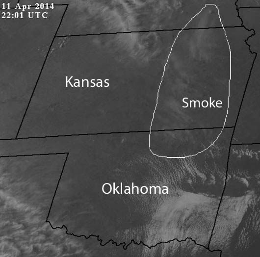
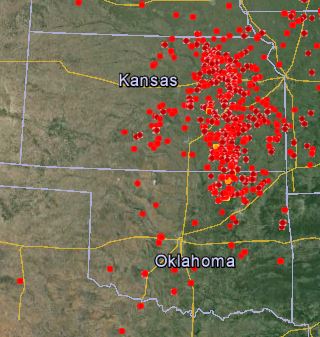
After the discussions on Wildfire Today about the use of prescribed fire in the Flint Hills of Kansas here and here, we, along with some of our readers, have been paying more attention to the use of fire in the state. Over the last 24 hours the weather in Kansas and Oklahoma must have been perfect for burning, because satellite images and the MODIS heat-detecting satellite have picked up a great deal of heat and smoke in the area.

Kansas-Oklahoma 2201 UTC, April 11, 2014

The visual satellite image above shows smoke in northeastern Oklahoma and eastern Kansas at 5:01 CDT, April 11, 2013.

Google Earth, Kansas Rx fires

The map above shows heat detected by the MODIS satellite during the 24 hours previous to 7 p.m. CDT, April 11, 2014.

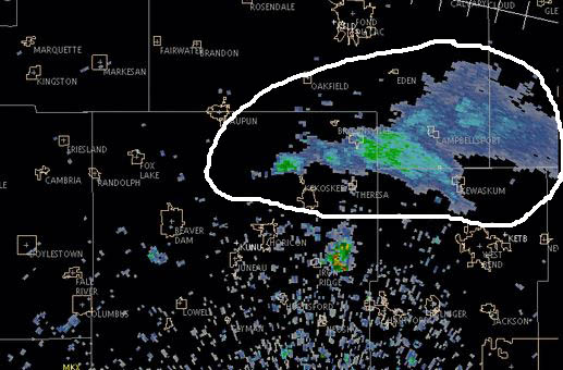
And speaking of smoke, the image below shows smoke detected by radar today from a fire in Horican Marsh, midway between the towns of Horicon and Waupun in Wisconsin. Click here to see an animation of the smoke as the fire increased in size.

Horican Marsh Fire

 
Thanks and a hat tip go out to Darren.