Red Flag Warnings and smoke map, August 5, 2013

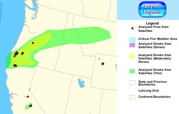
Wildfire smoke map, 9:36 a.m. MDT, August 5, 2013

Central Oregon is experiencing “moderately dense” smoke today from the fires in southwest Oregon and northwest California, according to this analysis from NOAA. If you want a ton of more information about the smoke, they have a very detailed description.

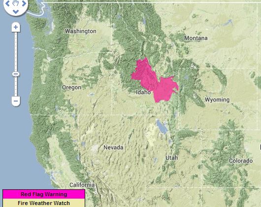
Red Flag Warnings, August 5, 2013

Red Flag Warnings and Fire Weather Watches for enhanced wildfire danger have been issued by the National Weather Service for areas in Idaho.

****

The Red Flag Warning map above was current as of 10:03 a.m. MDT on Monday. Red Flag Warnings can change throughout the day as the National Weather Service offices around the country update and revise their forecasts. For the most current data, visit this NWS site.

California: Orleans and Salmon River fire complexes

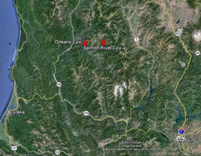
Map of Orleans and Salmon River Complexes of fires
Map of Orleans and Salmon River Complexes of fires (click to enlarge)

Two complexes of fires in northern California, shown on the maps, are seven miles apart but are on different national forests, which could be one reason they have not been combined into just one complex.

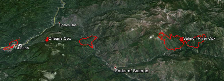
3-D Map of Salmon River and Orleans Complexes of fires August 3, 2013
3-D Map of Salmon River and Orleans Complexes of fires August 3, 2013 (click to enlarge)

Salmon River Complex 

The Salmon River Complex on the Klamath National Forest consists of at least two fires that as of early Sunday morning were about a tenth of a mile apart, burning 6 miles northeast of Forks of the Salmon, 2 miles northwest of Sawyers Bar, and 64 miles northwest of Redding. The Type 1 California Interagency Incident Management Team One assumed command of the Complex at 6 p.m. Saturday.

Orleans Complex 

The Orleans Complex comprises two fires on the Six Rivers National Forest. The Dance Fire is right at the community of Orleans and is burning on both sides of Highway 96. It started July 29 and is contained. The other is the Butler Fire 7 miles east of Orleans and about 49 miles northeast of Eureka. It was detected July 31, is listed at 3 percent containment, and has burned 1,463 acres. Northern California Interagency Team Two is managing the incident.

Salmon River Road, also known as Highway 93, is adjacent to three of these four fires and is closed.

Below is an update from the incident management team:

The fire reached the Morehouse Mine area, where structures are threatened. As of this morning, the fire lines are holding around those structures. The fire continues to burn mostly on the south side of the Salmon River in the area east of Butler Flat. Efforts to reach a spot fire on the north side of the river continue to be hampered by poor visibility and steep terrain. The fire was active around the perimeter yesterday and progressed across Lewis Creek (on the southern side) and into Grant Creek drainage (on the northeastern side). The fire is burning in the fire scars of the Hog Fire (1977). Difficult terrain, heavy vegetation, snags and poor access to the fire have continued to limit firefighting strategies. Crews are working today to open and utilize lines from the Somes Fire (2006).

Smoke issues

All of these fires are burning in an area that is infamous for long-duration fires subject to frequent inversions that trap wildfire smoke, sometimes creating air quality and health issues for sensitive residents. The incident management teams are referring residents to these websites for more information about the smoke:

On Saturday dense smoke limited the use of aircraft and the ability of fire managers to get an aerial view of the fires. A USFS fixed-wing aircraft using infrared equipment mapped the Salmon River Complex Saturday night.

Semi truck goes airborne before crash

There are a couple of four-letter words in the audio of this video. The driver of the airborne semi truck in this video (which was captured by the driver in the other truck, from whose perspective you’re watching the video) told police he swerved to avoid another vehicle that had drifted into his lane. His truck then left the interstate, went up an embankment at an overpass, then struck the guardrail on the cross street, ripping off the saddle fuel tanks, spilling fuel that caught fire. The driver suffered some minor facial and head injuries and his seven-year-old son, a passenger in his semi, suffered only a few scratches.

The accident occurred in Indiana near Interstate 74 and U.S. 421.

Wildfire briefing, August 2, 2013

Senator asks U.S. Army to explain the Stuart Creek 2 Fire

Alaska Senator Lisa Murskwski placed language in a Department of Defense appropriations bill on Thursday that would require the U.S. Army to explain their decision to conduct artillery training that may have started what became the massive Stuart Creek 2 Fire near Fairbanks, Alaska. Before the training began both the BLM and the Fort Wainwright Fire Department told the Army not to train that day because a Red Flag Warning was in effect for extreme wildland fire danger, but the artillery practice went on as planned.

Below is an excerpt from the Alaska Dispatch:

The fire is still smoldering in some areas, but does not threaten the road or any structures. BLM said it is now 71% contained. Everyone agrees the Stuart Creek 2 wildfire near Chena Hot Spring Road, east of Fairbanks — started on June 19, shortly after a Fort Wainwright artillery unit fired rounds into the woods and brush. The Army, Bureau of Land Management, Alaska Fire Service, and residents near the flames agree it flared up during strong winds in early July, forcing the evacuation of hundreds, and sending fire crews scrambling to keep it at bay. But the cause of the fire is now being debated — at least among Army officials.

“The official cause of the fire has yet to be determined, and we are working with BLM and the Fire Service to figure that out,” said Alaska Army spokesperson John Pennell.

On July 3, after the fire began growing rapidly, the commander of Fort Wainwright, Col. Ron Johnson, told a crowd of residents that live near the fire zone that the artillery training did, in fact, start the blaze.

“It was artillery training, it did start a fire,” Johnson said.

Evacuation warning scam?

In southern Oregon, Josephine County Sheriff Gil Gilbertson is investigating a case of someone going door to door on Hugo Road west of Interstate 5 telling residents they needed to evacuate because fires were getting close. It sounded like it could be true to some of the homeowners because fires had already caused some evacuations in the area. But there was no danger and the person was not authorized to evacuate residents. The Sheriff is working under the assumption that the resulting empty houses would make for easy pickings for a thief.

Fire fatality in Oregon identified

The person that was killed by a falling snag on Thursday has been identified as John Hammack, of Madras, Oregon. The incident occurred on a lightning-caused fire, the 398 Fire, north of Highway 242 near Dugout Lake outside of Sisters. Norman Crawford of Sisters was injured in the same incident. The two firefighters were contract personnel working as a tree falling team employed by R&K Water Services out of Bonney Lake, Washington.