Congress temporarily averted a wildland firefighter pay cliff when it narrowly stopped a government shutdown at the end of September. As that stop-gap nears its expiration on November 17, senators are making new pushes to increase wildland firefighter pay.
Nevada Senators Jacky Rosen and Cortez Masto introduced the “Wildland Firefighter Fair Pay Act,” which would permanently raise firefighter pay caps. The legislation, if passed, would also expand eligible employment to NWS meteorologists deployed with firefighters and would require a report from the USDA and DOI and NWS on necessary staffing levels of wildland firefighters and meteorologists.
The senators had previously written a letter to legislators urging them to include a permanent salary increase for wildland firefighters in the government funding bill.
“Nevada’s wildland firefighters are heroes who keep our communities safe,” Rosen said. “We must provide them with the pay they deserve, and I’m glad to help introduce this bipartisan legislation to permanently increase their overtime pay caps.”
The bill isn’t the only piece of legislation trying to improve conditions for wildland firefighters. The Wildland Firefighter Paycheck Protection Act (WFPPA) would authorize premium pay for federal firefighters portal-to-portal whenever they respond to an incident. The act was introduced to Congress before the shutdown was temporarily averted, but was never voted on.
There were 11,187 wildland firefighters (of GS-9 and below) employed through the USFS as of July 25, the according to the agency website. Funding proposed for the next fiscal year would reportedly support the hiring of 970 more firefighter positions, but Congress has yet to make that budget a reality.
If neither bill is approved by November 17, when the government shutdown stopgap is set to expire, wildland firefighter pay will be reduced by either 50 percent of current salary or by $20,000 annually, whichever is lower. It’s expected that the reduction could lead to a third of wildland firefighters walking off the job, according to the employee union and others.
Over 18 million hectares (more than 44 million acres, roughly the size of North Dakota), were burned during Canada’s record-breaking wildfire season this year, according to the Canadian Interagency Forest Fire Centre (CIFFC). Canada usually sees only 2.5 million hectares burn annually. Although the number of fires that burned this year isn’t unusual — 6,595 as of October — many of the fires that did burn spread to “megafire” status.
Newly released NASA satellite imagery shows the day-by-day expansion of some of these megafires. The year’s second-largest fire burned 1,224,938 hectares (4,730 square miles) southeast of Sakami in Quebec; it was fully contained in late July.
NASA satellite imagery also shows the spread of four wildfires in and south of the Northwest Territories. The western-most fire, burning near Fort Nelson, stopped spreading in August after burning 802,575 hectares. It then was reignited by winds in late September and early October and spread to 1,294,096 hectares, becoming the state’s largest wildfire as of November 4. The animation details the fire’s first spread.
Scientists tracked the fires with the new “Fire Events Data Suite” (FEDS), which draws on data from a group of satellites called VIIRS. “The thing that really sets FEDS apart is that the system excels at tracking the daily, incremental spread of fires at 12-hour intervals,” said Yang Chen, an atmospheric scientist at the University of California, Irvine. “That makes near real-time monitoring possible and allows us to generate much more detailed views of fire progression than we have been able to do in the past.”
The new system will reportedly help fire crews pinpoint the parts of a fire perimeter that are actively burning and identify residual heat from the fire that may pose a hazard to wildland firefighters.
Reducing fuels, increasing wildland firefighter resources, and building more firebreaks are all techniques used in tandem to reduce wildfire risk. Still, they often come with high up-front prices and uncertain long-term payoffs. A new study claims to have found a new mitigation strategy that sidesteps both issues: growing and maintaining banana trees with recycled water.
Some regions have considered building physical buffers out of concrete or metal to reduce fire risk, but those have high installation costs, require annual maintenance, and provide no additional revenue or benefits. So this study’s researchers focused on potential “edible fire buffers,” or specific vegetation that could be grown in wildfire-prone areas that would also produce a crop — and help add to the area’s economy.
To find the best candidate, the team modeled edible fire buffers by examining how the conditions of a historic fire would have changed if the crop had been present. The study used specifically the 2017 Tubbs Fire, since it fit the requirements of burning in a semi-arid region, originated in wildland, was spread by high winds, and then caused significant loss of life and property. The fire burned three California counties in October and was at the time the most destructive fire in the state. The research team used satellite, census, and fuel-type data from Santa Rosa at the time of the fire.
The study found that bananas were the most viable crop among its choices after testing multiple other possibilities. Vineyards, the most common high-value crop in Mediterranean climates, were too flammable to be considered viable for the study. Ginger is a low-flammability crop, but requires mechanical harvesting that could eat into potential revenue. Carob trees are low-flammability, high-yield, and high-value — but are better suited for areas where irrigation is unavailable or too costly.
The banana trees’ high water content, minimal management needs, and suitability for semi-arid and Mediterranean locations such as like California, Mexico, Chile, Australia, and South Africa drove researchers to and in-depth study the crop’s suitability.
“A medium-sized (633 m) banana buffer decreases fireline intensity by 96 percent, similar to the combination of prescribed burns and mechanical thinning, and delays the fire by 316 min, enabling safer and more effective firefighting,” the study said. “We also find that banana buffers with average yield could produce a profit of $56k USD/hectare through fruit sales, in addition to fire mitigation.”
The study found that not only would banana trees mitigate fire under current conditions, but the the trees would still have a protective effect as fires worsen and the climate changes.
Wildfire simultaneity, or numerous large wildfires burning at the same time, will become at least twice as frequent by 2085, researchers are warning. A steadily increasing number of large wildland fires — and the number of acres burned — has occurred over the past few decades in the American West, but new research has found that simultaneous large fires will burn even more often.
“Future regional increases in simultaneous large Western USA wildfires” was published in the International Journal of Wildland Fire by the University Corporation for Atmospheric Research; it focused on wildfires that burned 1,000 acres or more between 1984 and 2015. Researchers used multiple fire indices to model how simultaneity will likely change over the next 60 years. The study also measured the fires by Geographic Area Coordination Centers to see whether some geographic areas might see greater increases compared with others.
Simultaneous wildfires were projected to increase in every area of the West. Not only were “bad years” projected to increase, but increases in simultaneity also led to more intense wildfires. Peak season for simultaneous wildfires was projected to become several weeks longer by the end of the century.
“The trend was particularly pronounced for the most severe wildfire seasons — those that currently occur only every 10 years on average,” the National Center for Atmospheric Research said. “In the future, such seasons may be expected to occur at least twice as often, and up to nearly five times per decade in the northern Rocky Mountains, which was the most affected region.”
Projected seasonality of simultaneity
The findings point toward a risk in an already understaffed and under-resourced wildland firefighting force. Because crews are transferred across the nation, or sometimes even across nations, to battle fires depending on when an area’s season peaks, an increase in peak season length could mean major challenges for firefighters and fire managers.
“Because firefighting decisions about resource distribution, pre-positioning, and suppression strategies consider simultaneity as a factor, these results underscore the importance of potential changes in simultaneity for fire management decision-making,” the study says.
Steps can reportedly be taken to lessen the future risk of simultaneous wildfires, including thinning forests, conducting prescribed burns, and increasing numbers of firefighting crews and equipment. But that will depend on how long it will take to make those changes.
“The strain on resources created by simultaneous fires can affect the ability to conduct prescribed burns and pursue other preventative action,” the center said.
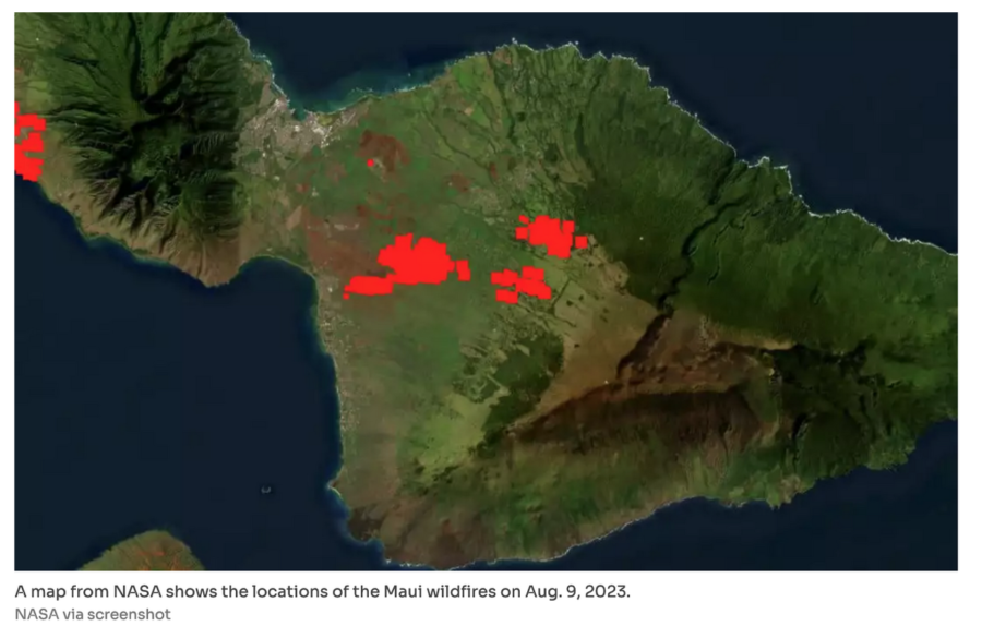
The fires may have been controlled in Maui, but the fires that burned Lahaina will continue to affect the island in numerous ways.
Experts at the University of Hawaiʻi at Mānoa explained the multiple long-term health and environmental risks during a recent webinar sponsored by the Hawaiʻi Public Health Institute. The webinar was focused specifically on addressing community concerns over remaining toxic chemicals and how people can protect themselves from exposure. There is also little to no precedent for the wildfire seen in Lahaina.
“While there have been large urban fires in other locations, such as Paradise, California, few have been related to hurricanes,” said Catherine Pirkle, an associate professor and global health researcher trained in epidemiology and health services.
Another unusual aspect of the Maui wildfires is their proximity to nearshore tropical reefs. Researchers know very little about the health effects of exposure to compex chemical mixtures from wildfires like those in Maui. The contaminants released by the fire may enter the marine environment and could pose risks for swimmers and people who eat contaminated fish.
While the specific consequences of contamination aren’t known, researchers said the most at-risk populations for developing long-term health issues related to the fire are pregnant women and children, older or low-income people, those with pre-existing health conditions, and people at risk of work-related exposure.
The Hawaiʻi Department of Health and the EPA have already determined that particulate matter from the wildfires caused only low levels of air pollution. Additionally, volatile organic compounds were detected in only a small number of drinking water samples. Researchers offered health guidance to anyone planning to re-enter burned areas, saying they should wear an N95 mask that fits well, along with long sleeves and pants, socks, shoes, and gloves.
“Minimize disturbing the ash that has settled on the ground so that it does not enter the air or nearby waters,” the researchers said. “To reduce the take-home pathway of exposure, people who enter the impacted area should change their clothing before returning to their family members who are advised against entering the impacted area.”
The guidance follows the announcement by Maui Mayor Richard Bissen that he would be reopening all of West Maui — except the burned-out sections of Lahaina — to tourism on November 1.
Watch the University of Hawaiʻi’s full webinar here:
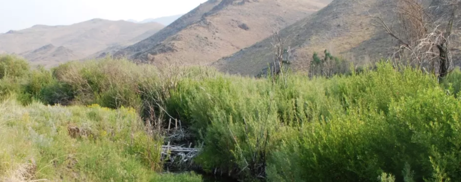
Researchers in Colorado have built hundreds of dam-like structures in hopes of mimicking a fraction of the success the state’s beavers have had throughout history. Ashley Hom with the U.S. Forest Service co-leads Colorado’s largest beaver-based restoration project — along with many partners. In just two years, this team built 316 beaver mimicry structures, about half of which were BDAs, or beaver dam analogues — manmade structures that imitate beaver dams. Many of them were constructed by volunteers, according to a story by Julie Cleveland.
These BDAs are built using wooden fenceposts and willows that act as a low-cost and low-maintenance structure to protect areas from wildfire while maintaining or improving water quality.
The loss of keystone beaver populations has caused a negative impact on watersheds throughout the western United States. Dams that beavers create slow the flow of spring run-off while raising the water table to keep the landscape wet. Without beavers and their dams, streambanks have eroded, causing snowmelt and run-off to drain too quickly from the landscape.
Beaver dam on Baugh Creek near Hailey, Idaho. USFWS photo
“As beavers create and maintain wetlands, the outcomes are vast,” Cleveland wrote. “A lack of beavers has resulted in an increased intensity of drought and wildfires in the West as fires spread rapidly across parched landscapes. Wetlands act as natural fuelbreaks, giving firefighters a chance for containment.”
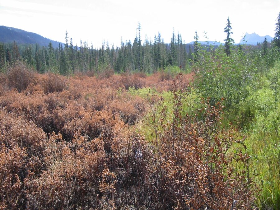
The effectiveness of beavers against wildfires has been seen in real-time. The 2018 Sharp Flats Fire burned more than 60,000 acres in Idaho, but seemingly left one area untouched.
Idaho Fish and Game officers load a beaver into a wooden box before he’s loaded on a plane and dropped into the Idaho backcountry. IDFG photo
Nearly 70 years beforehand, Idaho Fish and Game had rounded up and relocated beavers, sometimes by parachute, throughout the state, including the Baugh Creek area.
Beavers in wooden boxes drop from a plane into the Frank Church Wilderness to start a new life. IDFG photo
The Sharp Flats Fire burned all of the land around Baugh Creek, but the beavers’ dams and the wetland they created were left unburned.
The contrast was so stark that researchers at Boise State University and Utah State University teamed up with NASA to start building tools to measure the benefits of beaver reintroduction in other areas of the country.
Post-burn image of the Sharp Flats burn, image by NASA.
Watch the below video to see what researchers are paying attention to after beavers make their way back to wetlands — beaver rewilding as measured by NASA:
Alert reader Tom Jones sent over some photos he took of the beaver habitat on the B&B Fire in Oregon.
“We were with the NW Oregon type 2 team in September 2003,” wrote Tom. “Robert Alvarado was the Human Resource Specialist (HRSP) and I was the FBAN. Robert liked to go out on the line and talk with the crews to see how they were doing. I went to the line every day, so he would go with me. Each morning after briefing he would ask me, ‘What kind of adventure are we going to have today?’ The last two photos are of me and Robert at Marion Lake.”
Beavers’ fireline, B&B Complex 15. September 2003. Tom Jones photo.Beaver swamp burned, B&B Complex, September 2003. Photo by Tom Jones.Robert Alvarado and BeaverLine, 2003 photo by Tom Jones.Fireline put in by beavers on the B&B Complex in Oregon. 2003 photo by Tom Jones.Robert Alvarado at Marion Lake on the B&B Complex in Oregon. 2003 photo by Tom Jones.FBAN Tom Jones with the NW Oregon type 2 team in September 2003 on the B&B Complex. Photo by Robert Alvarado. (I didn’t know there were crocodiles in Marion Lake, did you?)
from Wikipedia: The B&B Complex was a linked pair of wildfires that together burned 90,769 acres (367.33 km2) in Oregon in the summer of 2003. The complex began as two separate fires, the Bear Butte Fire and the Booth Fire; the two fires were reported on the same day and eventually burned together, forming a single fire area that stretched along the crest of the Cascade Mountains between Mt. Jefferson and Mt. Washington. On the western side of the Cascades, the fire consumed mostly Douglas-fir and western hemlock. On the eastern side of the mountains, the fire burned mostly Ponderosa pine, lodgepole, and jack pine. Most of the burned area was on USFS land, including 40,419 acres (163.57 km2) within the Mt. Jefferson Wilderness. The fire also burned forest land on the Warm Springs Indian Reservation and small areas of state and private land. Firefighters worked on the fires for 34 days.
THANKS, Tom, for the great photos and another
piece of Beaver history in the Beaver State! ~ Kelly Andersson


