A lawsuit was filed January 18 against Pacific Gas & Electric Co. by El Dorado County and Placer County seeking damages related to the 2022 Mosquito Fire, which burned almost 77,000 acres over 50 days in the Sierra Nevada foothills. The two counties, along with the El Dorado Water Agency, Georgetown Divide Public Utilities District, and Georgetown Divide Fire Protection District, filed the lawsuit in San Francisco Superior Court. The fire burned mostly on the Tahoe and El Dorado National Forests and caused evacuations of more than 11,000 people.
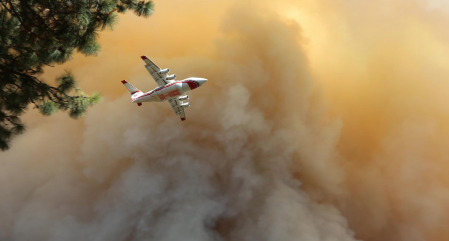
An airtanker makes a retardant run over the Mosquito Fire after it jumped the American River and headed north toward Foresthill, California. 09-13-22 Inciweb photo.
The suit alleges that PG&E’s equipment caused the fire, which started on September 6 near the community of Foresthill, according to a report by CBS News.
“The lawsuit seeks to hold PG&E accountable and to help our community rebuild after this devastating fire,” said El Dorado County counsel David Livingston. The Mosquito Fire started near the Oxbow Reservoir at the Middle Fork American River, according to the Sacramento Bee, and it destroyed 78 structures, including dozens of homes in the Placer County community of Michigan Bluff and the El Dorado County town of Volcanoville. It was not contained till October 27.
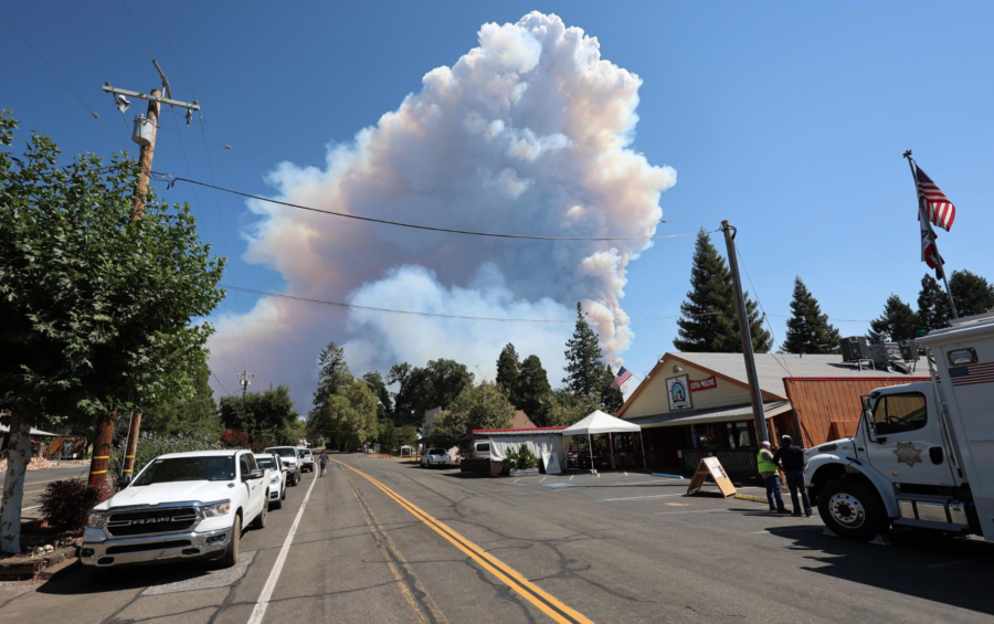
Extreme fire behavior on the second day produces a large column of smoke visible from Foresthill, California. 09-08-22 Inciweb photo
The county filed the lawsuit one day before PG&E officials were scheduled to appear in Shasta County Superior Court for a criminal case related to the 2020 Zogg Fire, which killed four people and which Cal Fire investigators have blamed on PG&E equipment. Shasta County prosecutors charged PG&E with four counts of involuntary manslaughter; the utility company in June pleaded not guilty.
The Mosquito Fire lawsuit follows a legal settlement earlier this week in which 10 public entities agreed to $24 million from PG&E for damages caused by the 2021 Dixie Fire, which started July 13 and burned over 963,300 acres across Plumas, Lassen, Butte, Shasta, and Tehama counties. Plaintiffs include the five counties, along with the City of Susanville, Plumas District Hospital, Chester Public Utility District, Honey Lake Valley Recreation Authority, and Herlong Public Utility District.
“Local government across the five affected counties came together to recover these significant funds to reimburse public and natural resources lost in the fire,” Gretchen Stuhr with Plumas County told The Plumas News. “The allocated portion of the settlement proceeds will in no way make the entities whole following the devastation caused by the Dixie and Fly Fires but will assist the County in its recovery.”
Garfield County in west-central Colorado signed off this week on the new multi-agency Roaring Fork Wildfire Collaborative, but not without a little creative editing. The Post Independent reported that county commissioners signed a memorandum of understanding (MOU) joining 17 other local governments, fire districts, and state and federal agencies in the formation of the wildfire collaborative.
“The Roaring Fork Valley presents especially complex boundaries with the sheer number of agencies involved,” said Larry Sandoval with the BLM’s Colorado River Valley Field Office. He said the completion of this MOU is a major step toward effective collaboration in fire prevention and management.
The request for edits to the MOU originated with Garfield County Commissioner Tom Jankovsky. “A lot of the emphasis is coming from Pitkin and Eagle counties and the Forest Service to do more forest management,” he said, “which from my perspective is more than just prescribed burns.” Jankovsky wanted the MOU to include equal mention of logging, thinning, and other “more aggressive” forest management methods. “I find it ironic that this group talks about climate change, yet they look at forest management as burning the forest, which has the same effect as if we have a forest fire, just to a much smaller degree,” Jankovsky explained.
A third-generation native Coloradan, Jankovsky is serving his third term as Garfield County Commissioner. He is the public lands planning lead for the Board of County Commissioners and the former general manager of Sunlight Mountain Resort in Glenwood Springs. He asked that the word “climate” be removed from one sentence in the MOU where it stated that active management “… includes the use of the best available climate science that will help stakeholders understand how a changing climate will impact our landscapes and ecosystems, while also looking for opportunities to improve understanding through local research.” Jankovsky wanted the line to read “best available science” and not “best available climate science.”
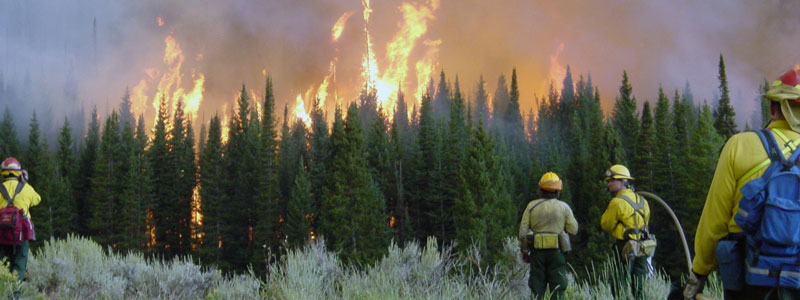
Fire photo by Colorado State Forest Service
Because fires have no boundaries and don’t recognize jurisdiction lines, the valley-wide collaborative is meant to have everyone on the same page. The 18 local, county, state, and federal agencies involved in wildfire management formalized their working relationship through the Roaring Fork Valley Wildfire Collaborative; the Gunnison Times reported that talk of the collaborative started early 2022, when residents in the Roaring Fork River drainage discussed their interest in better fuels treatment. With several big fires in recent memory — the 2018 Lake Christine Fire, the 2020 Grizzly Creek Fire, and the 2021 Sylvan Lake Fire — valley stakeholders began discussing solutions. The collaborative’s goals include improving communication and identifying critical areas of fuels reduction and vegetation treatment.
Signatories to the MOU are Aspen, Snowmass Village, Basalt, Carbondale, Glenwood Springs, and Marble. County signatories are Pitkin, Eagle, Garfield, and Gunnison counties. Additional collaborators include Aspen Fire, Roaring Fork Fire and Rescue, Carbondale Fire, Glenwood Springs Fire, the U.S. Forest Service, and the BLM.
The 2002 Hayman Fire was the largest wildfire in Colorado state history for nearly 20 years, until the Pine Gulch Fire surpassed it in August 2020. The Cameron Peak Fire became the largest wildfire in Colorado history seven weeks later at 206,667 acres. With multiple record-breaking fires, the 2020 Colorado wildfire season became the largest in state history after burning 665,454 acres.
Large-scale wildfires are becoming increasingly common in the U.S. as climate change accelerates; since 2000 an annual average of 70,072 wildfires have burned an annual average of 7 million acres across the country. According to research by the College of Natural Resources at North Carolina State University, that’s more than double the annual average of 3.3 million acres burned in the 1990s, when a greater number of fires occurred annually. A 2016 study found that climate change had doubled the number of large fires between 1984 and 2015 in the western U.S., and a 2021 study supported by NOAA concluded that climate change has been the main driver of the increase in fire weather each season.
In Boulder, Colorado, Democratic State Rep. Judy Amabile says people are having difficulty finding affordable home insurance. “It seems like across broad areas certain companies have decided we are not going to insure in this area,” she told 9News-TV. “They are having to make a lot of calls and the prices have gone up a lot and they are having difficulty finding anything.”
Amabile plans to introduce legislation to create a “last-resort” insurance plan provided by the state of Colorado. “The plans on that program are going to be really bare-bones and they are going to be very expensive.” She said at least 30 other states now have last-resort homeowners’ insurance programs like this, as more companies are increasing rates or even refusing to insure wildland/interface homeowners at all.
“Across the board, we are seeing 20 to up to 50 percent increases in renewals,” said independent insurance agent Morgan Lloyd.
Homeowners have moved into and built homes in wildland/urban interface areas for decades with little regard for the multiplying fire risk (and evacuation dangers) posed by increased development and neglected fire-safety mitigation. In some areas of the West, homeowners (along with homeowners’ associations, insurance companies, and local governments) are now facing the realities of paying for this development. NBC Los Angeles reported that more and more homeowners in southern California are being dropped by insurance companies because of wildfire risk. They talked with homeowners near Pomona whose insurance companies canceled their policies even though no wildfires have burned near their homes for years. Others’ premiums increased by 800 percent.
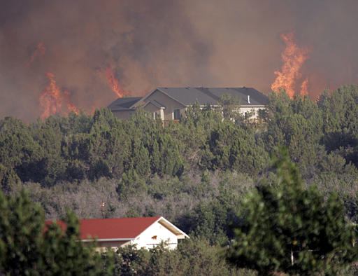
Interface photo from Great Basin Coordination Center
The Insurance Journal reported last month that California, Florida, and Texas are the states with the highest number of homes at risk of wildfire, but that other states also are faced with large and increasing risk. Colorado and New Mexico, for example, have fewer homes overall, but project fires can wreak tragedy on a much larger proportion of their populations. New Mexico’s Santa Fe County counts nearly 34,000 properties at risk of wildfire, but the county housed a population of only 155,000 in 2020. This ratio of vulnerable homes to the overall population underscores the magnitude of population displacement assistance, reconstruction resources, and economic recovery expense required after a major wildfire.
With wildfire danger threatening the liquidity and solvency of insurers, the California Department of Insurance has proposed new regulations to incentivize risk reduction on covered properties and neighborhoods. In October, the state Insurance Department issued regulations to recognize and reward wildfire safety and mitigation efforts by homeowners and businesses. The InsuranceNewsNet reported that California’s “Mitigation in rating plans and wildfire risk models” regulation is the first in the nation requiring insurance companies to provide homeowner discounts under the “Safer from Wildfires framework,” which the California Department of Insurance and state emergency preparedness agencies created last year. The regulation requires insurance companies to submit new rate filings incorporating wildfire safety standards. The new rates must recognize the benefit of safety measures such as upgraded roofs and windows, defensible space, and community programs such as Firewise USA and the Fire Risk Reduction Community designation developed by CAL-FIRE.
::: UPDATE: Highway to the Danger Zone :::
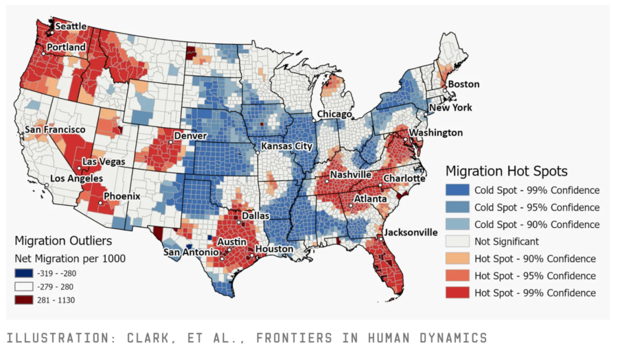
Matt Simon recently wrote an eye-opening piece for WIRED about a study examining numbers of residents moving into and out of fire danger zones (and hurricane regions) across the country. Wildfires in the West have grown increasingly devastating in part because of climate change, but also because more humans are moving deeper into areas that once were intact or contiguous forests. That overlap between development and wildlands, Simon noted, now exposes more people to fires and provides more opportunities to ignite them.
Americans are “flocking to fire,” say the authors of a study published last month in the journal Frontiers in Human Dynamics. Using census data, the researchers found that people are increasingly moving to areas that are more prone to catastrophic wildfires or plagued by extreme heat. And though some affluent Americans are seeking the beauty of forested areas, economic pressures are forcing others there, too: Skyrocketing housing prices and cost of living are pushing people toward more rural places where homes are cheaper.
“As temperatures increase — as things get drier and hotter and prices for housing get more unaffordable — it’s definitely going to push people into these rural areas,” says Kaitlyn Trudeau, a data analyst at the nonprofit Climate Central. “Some people don’t have a choice.”
Increases in the number of people living in wildfire zones come at a huge cost: the 2018 Camp Fire that destroyed Paradise, California, resulted in an estimated $16.5 billion in losses.
January is Firefighter Cancer Awareness Month, and the International Association of Fire Fighters (IAFF) says that cancer is the leading cause of death among firefighters. Annual deaths from various forms of cancer account for more than 74 percent of the line-of-duty deaths added to the IAFF fallen firefighter memorial wall of honor each year.
The National Firefighter Registry program is finalizing its enrollment web portal, a voluntary registry of firefighters that collects occupational, lifestyle, and health information on firefighters to evaluate cancer rates and cancer risk factors in the U.S. fire service. The NFR was created by the Firefighter Cancer Registry Act of 2018 in response to growing evidence of carcinogenic exposures and increased risk for cancer faced by firefighters. The NFR is maintained by the U.S. National Institute for Occupational Safety and Health (NIOSH).
All U.S. firefighters, no matter their length of service, can participate in the Registry, including:
Active, former, and retired firefighters
Career, paid-on-call, and volunteer firefighters
Structural firefighters
Wildland firefighters
Industrial firefighters
Military firefighters
Instructors
Fire investigators
Other fire service members
The Firefighter Cancer Support Network (FCSN) provides public education on the issue of cancer risk for firefighters. For more than 16 years the FCSN has provided support for firefighters and EMS members who have been diagnosed with cancer. The firefightercancersupport.org website includes information to educate firefighters and raise awareness about why cancer cases are on the rise in the fire service and how to limit day-to-day exposures to carcinogens. Resources are available for firefighters diagnosed with cancer.
Since 2005, the nonprofit FCSN has provided assistance and one-on-one mentoring to thousands of cancer-stricken firefighters and their families. FCSN also delivers extensive firefighter cancer awareness and prevention training nationwide.
When local residents who aren’t firefighters see summertime haze or clouds on the horizon, they often guess it’s smoke. Mid-summer they often think it’s wildfire smoke, and in the fall they suspect it’s a prescribed burn. This is a “common experience” with wildfire smoke, according to attorneys with Oregon OSHA, who successfully argued last week that it’s fairly easy to determine when the air is smoky and affecting air quality.
On Tuesday, according to the Salem Statesman Journal, a federal magistrate dismissed a lawsuit against Oregon OSHA in which plaintiffs claimed the state agency’s new heat and smoke rules somehow violated the 14th amendment of the U.S. Constitution and were unenforceable. Lawyers for Oregon Manufacturers and Commerce, Associated Oregon Loggers, and Oregon Forest Industries Council claimed that air quality fluctuations are caused by many factors, and not just wildfire smoke.
“Most times, it’s not obvious,” attorney James Anderson declared. “There’s no method to determine that air quality is due to wildfire smoke, or prescribed burn smoke, or other things that make up particulates.”
Magistrate Mark D. Clarke was not persuaded. “Why is it that complicated?” he asked. He said Oregonians are quite familiar with wildfire smoke. “I’m not sure any of us have any trouble knowing when wildfire smoke rolls in. I’m having trouble with that, factually.”
The lawsuit also claimed that OSHA’s rules to protect workers against extreme heat and smoke were too vague to be enforced. The new rules, as KGW-TV reported last July, took effect after recent heat waves in Oregon resulted in medical problems and deaths, prompting new requirements for employers to protect employees from heat-related illnesses. The new OSHA rules require, when the heat index hits or exceeds 80 °F, that employers provide shaded areas for workers to rest, more break time, and access to plenty of water. When temperatures exceed 90 then breaks must be longer, communication must be more frequent, and workers must be monitored more closely.
Dangerous heat exposure is risky especially for farm workers, according to Ira Cuello Martinez, policy director for Pineros y Campesinos Unidos del Noroeste (PCUN), Oregon’s farm worker union. “You’re constantly moving and doing repetitive motions, having to bend down, and there aren’t many shaded structures when it comes to the field or doing work in agriculture,” he said.