Cost of 18 wildfires in Colorado this year reported to be about $130 million

Spring Creek Fire

Above: Spring Creek Fire southwest of Pueblo, Colorado. Photo uploaded to InciWeb June 29, 2018.

Reporters at a recently created newspaper in Colorado dug up a great deal of information about the cost of the large wildfires that occurred in Colorado this year. Jennifer Brown and Jason Blevins authored an article in The Colorado Sun that broke down many different categories of costs, from portable toilets to firefighting aircraft.

The data they collected came from the Colorado Division of Fire Protection and Control. A federal agency has not responded to a records request the newspaper filed months ago.

The article concentrates on two of the largest fires in Colorado this year — Spring Creek  51 miles southwest of Pueblo, and Silver Creek near Kremmling.

Below is an excerpt from the article:

The drought-ravaged summer of 2018 was an expensive one for firefighting, with costs reaching an estimated $130 million for 18 fires, according to documents received by The Colorado Sun through a public records request to the state Division of Fire Protection and Control. Of that, the state’s share is more than $40 million.

That’s six times more than Colorado spent on fighting wildfires in 2017 and two and a half times what it spent in 2016. Ten fires last year cost just more than $10 million combined.

It is a very interesting well researched article –worth your time.

The Colorado Sun published their first edition on September 10. Many of the reporters came from the Denver Post and other newspapers that have had massive staff reductions in recent years. The Post, created in 1892, was purchased in 2010 by hedge fund Alden Global Capital, run by Heath Freeman under their Digital First Media umbrella. The organization has purchased 97 newspapers.

Below is an excerpt from an article published in Bloomberg March 26:

…But what sets Freeman apart is that he seems to have a rather unique view of a newspaper’s purpose. In this view, his papers are intended not so much to inform the public or hold officialdom to account, but to supply cash for Freeman to use elsewhere. His layoffs aren’t just painful. They are savage.

For instance, according to figures compiled by the NewsGuild, the union that represents workers at Digital First Media properties, the staff of the Denver Post has fallen from 184 journalists to 99 between 2012 and 2017.  The Pottstown Mercury in Pennsylvania went from 73 journalists in 2012 to 19 in 2017. That’s right: 19. The Norristown Times-Herald, also in Pennsylvania, shrank from 45 journalists to 12. The San Jose Mercury News and the Orange County Register, both of which had been dominant papers in their regions before Alden Global bought them, have also been decimated by layoffs.

[…]

But the pattern continues. Last week, no sooner had Digital First Media closed on its purchase of the Boston Herald than it announced that it would cut the staff from 240 employees to 175.

Thanks and a tip of the hat go out to Tom.
Typos or errors, report them HERE.

Report of “extreme spotting” 6 miles ahead of Klondike Fire

(Originally published at 5:34 a.m. PDT October 17, 2018)

Typically by mid-October firefighting agencies in Oregon have downsized their ranks of seasonal firefighters and are preparing to enter winter mode. But the Klondike Fire west of Grants Pass, after being dormant for weeks, exploded back to life on October 14 and in a big way. Within a matter of hours it burned an additional 4,968 acres to bring the total up to 172,287 acres.

According to an article in the Mail Tribune it was transporting burning embers into the atmosphere that started fires six miles out ahead of the flaming front:

“Extreme spotting” propelled fine embers up to six miles ahead of the main fire, dropping the live ash right between firefighters’ tents and close to people’s homes.

“We even had to move our own fire camp,”  [information officer Kale] Casey said.

The map below shows spot fires detected by an infrared mapping flight.

map Klondike Fire
The red line on the map was the perimeter of the Klondike Fire at 9 p.m. October 15, 2018. The white line shows where the perimeter was before the October 14-15 additional growth. Click to enlarge.

The Incident Management Team posted an update on Tuesday October 16:

Fire personnel focused all efforts to ensure that Sunday’s wind driven spot fires did not damage any of the homes in the Oak Flats, Spud Road and Agness area. Fire managers estimate that the weekend wind event resulted in approximately 5,000 acres of new growth to the west of the primary containment lines. Level 3 evacuations remain in effect for these areas while fire crews and engines work to construct and link together new and existing containment lines.

The Oregon State Fire Marshal’s five structural task forces that arrived yesterday have split into day and night shifts to ensure that all homes under evacuation are protected. These resources include twenty engines and five water tenders with firefighters from thirty-three different fire agencies from across the state.

Fire behavior moderated significantly yesterday as the 30 mph winds over the weekend diminished significantly, allowing fire firefighters to attack spot fires directly. Containing the remaining spot fires east and west of the Illinois River and west of the 3577 Road is the primary objective for all fire personnel.

Report concludes fire tornado with 136+ mph winds contributed to a fatality on Carr Fire

Fire tornado Carr Fire

Above: Fire tornado filmed by the Helicopter Coordinator on the Carr Fire July 26, 2018 near Redding, California. The video can be seen HERE.

A “Green Sheet” report on the two firefighter fatalities that occurred July 26, 2018 on the Carr Fire was released this week. Extreme fire behavior during a two-hour period led to a Redding Fire Inspector (FPI1) and a dozer operator (Dozer 1) being overrun by the fire and killed. The report concluded that FPI1, “suffered fatal traumatic injuries when entrapped in a fire tornado while engaged in community protection operations. Dozer 1 suffered fatal thermal injuries while he was improving fireline”, but the report did not say the entrapment was related to the fire tornado.

At times the media or the general public loosely throws around the term “fire tornado”, giving the name to fairly common much smaller fire whirls. But documented fire tornados are much larger, and usually a very destructive weather-induced fire phenomenon.

Below are excerpts from the Green Sheet report:


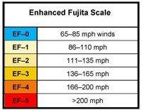
A large fire tornado was one of the primary causes of the entrapment and death of FPI1 on July 26, 2018. The fire tornado was a large rotating fire plume that was roughly 1000 feet in diameter at its base. tornado Fujita scaleWinds at the base of the fire tornado reached speeds in the range of 136-165 mph (EF-3 tornado strength), as indicated by wind damage to large oak trees, scouring of the ground surface, damage to roofs of houses, and lofting of large steel power line support towers, vehicles, and a steel marine shipping container within ½ mile of the entrapment site. The strong winds caused the fire to burn all live vegetation less than 1 inch in diameter and fully consume any dead biomass. Peak gas temperatures likely exceeded 2,700 °F.

Current understanding of how large fire tornados form and propagate suggests that necessary factors include high energy release rates, sources of vorticity (rotating air), and low to moderate general winds. All of these factors were present in the area of Buenaventura Boulevard on July 26. Observations from witnesses and other evidence suggest that either several fire tornados occurred at different locations and times, or one fire tornado formed and then periodically weakened and strengthened causing several separate damage areas.

[…]
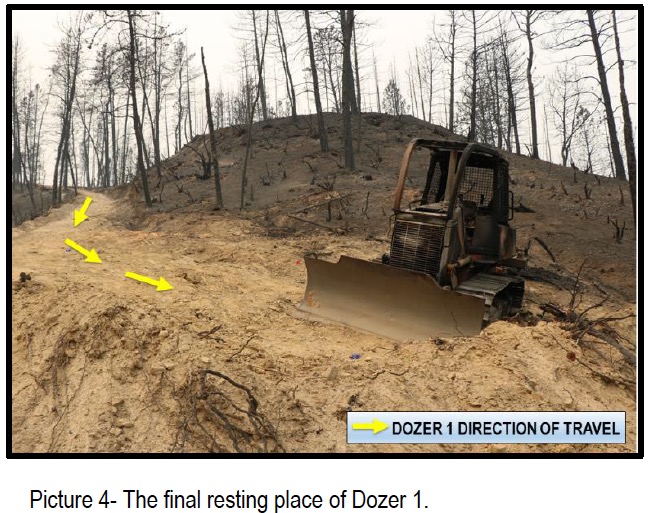
(From page 8-9; Dozer 1 was improving a dozer line toward Spring Creek Reservoir)
At approximately 5:44 p.m., the fire jumped the top of the dozer line near the access road (picture 2). Multiple spot fires became established in the area. Approximately two minutes later, CREW1 Leader returned to the water treatment plant and asked where Dozer 1 was located. CREW1 Leader was told that Dozer 1 had proceeded down the dozer line. CREW1 Leader made several attempts over the radio to contact Dozer 1 in order to tell him to “get out of there”.

Two firefighters from a local government engine strike team were positioned near the top of the dozer line and recognized the urgency of the situation. They attempted to chase Dozer 1 on foot, but were unable to make access due to increasing fire activity.

CREW1 Leader was finally able to establish radio contact with Dozer 1. Dozer 1 stated he could not get out because he was cut off by the fire, and he would push down instead. Sometime between 5:46 p.m. and 5:50 p.m., radio traffic was heard from Dozer 1 that he was on a bench attempting to make a safety zone. Dozer 1 was also requesting water drops.

At approximately 5:50 p.m., a CAL FIRE Helicopter (Copter 1) began making numerous water drops through the smoke in and around Dozer 1’s last known location. Copter 1 notified the Helicopter Coordinator (HLCO) of Dozer 1’s situation, and HLCO assigned three more helicopters to drop water in the area. HLCO noticed a dramatic increase in fire behavior; however, the helicopters continued to make water drops as conditions worsened. At approximately 6:08 p.m., Copter 1 was forced to land due to a temperature warning light resulting from the high atmospheric temperatures. Approximately 30 minutes later, Copter 1 returned to service and continued to drop water on Dozer 1’s location.Carr Fire fatality report

Continue reading

Report issued on one of the devastating fires near Athens, Greece

Greece wildfire July 2018

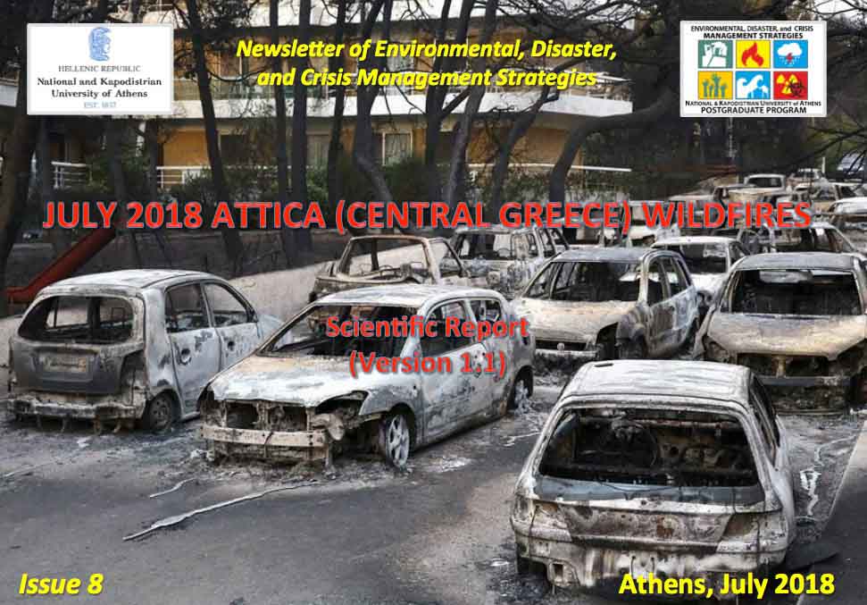
A report has been issued about one of the wildfires that recently burned into populated areas in Greece (covered by Wildfire Today here). The National and Kapodistrian University of Athens distributed the document in their Newsletter of Environmental, Disaster, and Crisis Management Strategies.

The fire started July 23, 2018 near the community of Kallitehnoupolis on Penteli Mountain, approximately 20km (12 miles) northeast of Athens and 5.6 km (3.5 miles) west of the Aegean Sea. With the extreme weather conditions it spread quickly east to Kallitechnoulopis, Neos Voutzas, Rafina, and reached Mati where it finally stopped at the coast.

The Fire Service responded, sending 60 personnel in  24 vehicles, 2 ground forces teams, 3 Canadair scooping air tankers, and a helicopter.

Pushed by strong winds out of the west the fire ran 5.6 km (3.5 miles) in about 90 minutes, moving through a densely populated area frequented by tourists.

From the report:

The aftermath is tragic. The fire burned approximately 1,276 ha (3,153 acres), estimated from satellite data. Within the area, there are approximately 1,220 totally destroyed buildings (according to official inspections) and 305 burned vehicles. The days following the event, the authorities recovered at least 91 bodies from the scene (updated July 31, 2018 at 11.00am). Several missing persons were reported and tens of injured (approximately 200 at some point) were transferred to nearby hospitals.

The wind speeds recorded by a network of weather stations were the highest seen during the summer months in the last eight years, with gusts of 100 to 120 km/hour (62 to 74 mph).

The rapid spread of the fire and with little effective notification, the residents and tourists in the communities in its path and the densely populated city of Mati had little chance to escape. The report said, “The population had almost zero time between risk awareness and reaction decision”.

Greece wildfire July 2018Many got in their vehicles and drove away from the blaze toward the coast. They encountered urban planning, or the lack of it, that included narrow streets, numerous dead ends, elongated blocks without the possibility of lateral escape, and the absence of areas that could serve as safety zones. The visiting tourists who were often not very familiar with the layout of the streets were at a particular disadvantage. The low visibility due to the smoke was another challenge.Continue reading

Report released for entrapments on Horse Park Fire

Horse Park Fire

Above: photo from the report.

Additional information has been released about the entrapments that occurred on the Horse Park Fire May 27 in a remote area of Southwest Colorado. Earlier we posted two videos that were shot when firefighters hurriedly retreated as the fire advanced, plus information from a “72-hour report”.

Now a 56-page Facilitated Learning Analysis and a 12-minute video are available that break down the incident in even more detail.

To very briefly summarize what happened, while scouting a road for a potential burnout operation, a hotshot crew superintendent and foreman encounter a wall of flames and attempt to retreat. Their truck becomes stuck, forcing them to flee on foot, narrowly escaping the rapidly advancing fire front. Just as they reach safety, they learn that their crew lookout is missing. After nearly 40 agonizing minutes, the lead plane pilot locates her after she ignited an escape fire. It is a compelling story, which is pretty well summed up in this video.

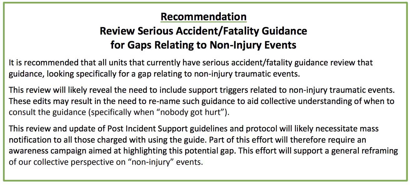
The 56-page report only has one recommendation:Recommendation horse park fire