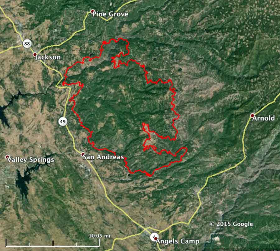
The Butte Fire south of Jackson, California has grown by about 6,000 acres in the last two days and is now listed at 71,063 acres.
CAL FIRE reports that 135 residences and 79 outbuildings have been destroyed.
Fire behavior remained moderate on Sunday allowing crews to be more effective in constructing fireline on the perimeter.
Butte Fire map, 9-13-2015. CAL FIRE.
Evacuations are still in place for many areas in Amador and Calaveras Counties. More details are available at the fire information phone lines: (530) 647-5218 and (209) 754-5527.
****
(UPDATE at 10:35 p.m. PT, September 12, 2015)
In a 9:15 p.m PT update from CAL FIRE, the size of the Butte Fire south of Jackson, California remained about the same during the day on Saturday, but damage assessment teams reported that they counted 86 homes and 51 outbuildings that burned in the fire.
Mandatory evacuations are still in place for numerous locations in Amador and Calaveras Counties. More details are available at the fire information phone lines: (530) 647-5218 and (209) 754-5527.
Over 3,800 personnel are assigned to the fire, along with 452 fire engines, 77 hand crews, 17 helicopters, and 94 dozers.
****
(UPDATED at 9:43 a.m. PT, September 12, 2015)
Engine 312 from the West Point Fire Protection District. Photo by SLOStringer, used with permission.
Two close calls have occurred on the Butte Fire south of Jackson, California. A truck from the West Point Fire Protection District burned in the private driveway of a home along Highway 26 . The person who took the photo above said it appeared the crew was doing structure protection and that they were able to avoid any major injuries.
The Modesto Bee has an article about “Modesto and Stanislaus Consolidated crews” that had to take refuge behind a structure as the fire “made a significant run at them [with] very erratic fire behavior”. The firefighters did not deploy fire shelters, but their vehicles suffered heat damage described as “cosmetic”, including “bubbled paint, melted plastic trim and melted hose”.
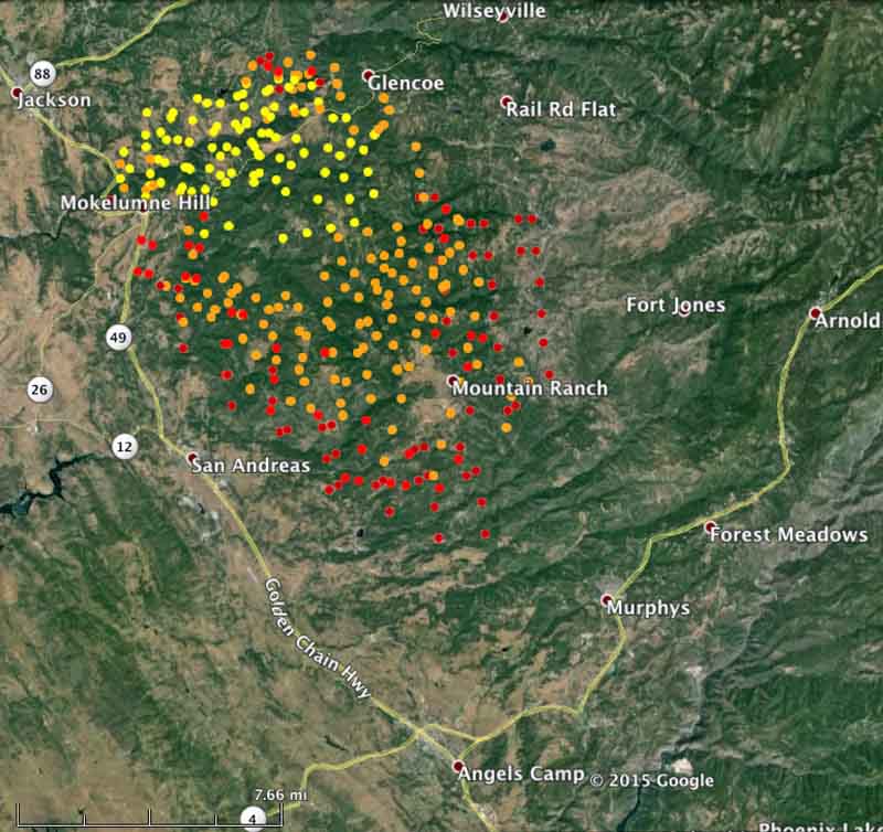
The red dots represent heat detected by a satellite over the Butte Fire at 1:37 a.m. PT, Sept. 12, 2015. The other colors are from earlier satellite overflights. MODIS. (click to enlarge)
CAL FIRE reports that the Butte Fire has burned 64,728 acres and has destroyed 15 structures. Other than evacuations and the number of firefighting resources assigned (3,330 personnel) CAL FIRE has provided little additional information about the fire. Saturday morning they did supply the map below which, although undated, appears to be fairly current.
CAL FIRE’s map of the Butte Fire obtained Sept. 12, 2015. No information was provided about the date of the perimeter.
****
(UPDATED at 5:30 p.m. PT, September 11, 2015)
The Butte Fire at 6:09 p.m. on September 10, as seen from above Jackson, CA, looking southeast. Photo by Matthew Rhodes.
CAL FIRE reported at 3 p.m. today that the Butte Fire south of Jackson has burned 50,000 acres since it started 46 hours before on September 9.
More areas have been added to the mandatory evacuation list in Calaveras and Amador Counties. Details are available at the Fire Information phone line, (530) 647-5218 and (209) 754-5527.
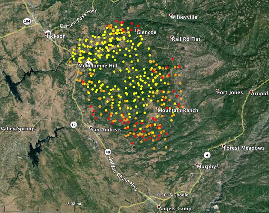
The red dots represent heat detected on the Butte Fire at 1:39 p.m. PT, Sept. 11, 2015. MODIS. (click to enlarge)
In this video Thomas Martin, a reporter from VICE, gets a close-up look at what it’s like to thin trees and construct fireline as he embeds with a crew from Grayback Forestry for a day, and gets outfitted with gear and swings a Pulaski for a few minutes.
At then end he sums up his impression of the work wildland firefighters do. And keep in mind during his time with the crew, it appears they were nowhere near a fire.
Firefighters around the world are universally acclaimed, and considered heroes. Forest firefighters, though, are in a league to themselves. They basically go into one of the deadliest situations in nature, something that we have all been instinctively hard wired to avoid on site or smell, no matter what. And get right up against the flames, and then do one of the hardest jobs imaginable, which is digging a ditch. It’s some of the hardest work I think that exists.
The three firefighters killed in a wildfire near Twisp, Okanogan County, last week died from smoke inhalation and “thermal injuries,” or burns, Okanogan County Coroner Dave Rodriguez said Friday.
The firefighters were driving up a steep gravel road and crashed down a 40-foot embankment, where the fire consumed them. The manner of death was classified as accidental.
Those killed Aug. 19 were Richard Wheeler, 31, Andrew Zajac, 26, and Tom Zbyszewski, 20.
A portion of the last edition of the NPS’ Morning Report, published August 31, 2015.
The National Park Service is discontinuing what became an institution over the last several decades. Their “Morning Report”, produced every week day, published its last edition on August 31, 2015. Many NPS employees, retirees, and people from outside the agency read it religiously.
For almost 30 years it was a summary of all kinds of incidents in the parks, and especially concentrated on storm impacts, major law enforcement actions, injured or killed park visitors, and fires on NPS lands.
It will be replaced by a list of news releases. The NPS explains that is an improvement because it is searchable.
The Morning Report was created, edited, and nurtured tirelessly by Bill Halainen, who early every morning combed through numerous incident reports and edited them into a very readable format. At one point, in the summer Mr. Halainen was providing a recurring chart that showed trends of firefighting resources that were committed nationally to fires — something the NIFC National Situation Report does not do.
An excerpt from the August 16, 2012 NPS Morning Report.
There are at least three reasons why the NPS is killing the Morning Report. Mr. Halainen is retiring — a second time. He first retired from the NPS in 2007, but continued writing the Morning Report on a contract basis until two days ago. But in September he retired for real. Another reason is, we have been told that the number of incident reports available to the Morning Report have decreased by 50 percent compared to how many were submitted in the 1990s. And thirdly, the NPS is not interested in funding an editor for the report.
Below is an excerpt from the April 24, 2015 Morning Report, breaking the news about the Halainens’ retirements:
****
“Delaware Water Gap National Recreation Area (PA) Cathy And Bill Halainen To Retire
Cathy Halainen, budget technician for the resource management division at Delaware Water Gap NRA, and Bill Halainen, a retired NPS employee who edits InsideNPS and the Morning Report, will both be retiring in September.
Cathy will bring to a close 20 years with the park’s Division of Resource Management and Science, where she has been responsible for almost all administrative functions for divisional staff. Before working for the National Park Service, she worked in a similar capacity for several colleges (the University of Massachusetts, Brandeis, and William and Mary) and government contractors, principally McDonnell-Douglas.
Bill worked as an interpretive and protection ranger, program manager and management assistant in various parks and offices from 1974 to 2007, during which time he created and edited the NPS Morning Report. He also became editor of InsideNPS in 2002, and continued editing both publications via contract after his retirement from the Service in 2007. He’s edited and published about 6,900 editions of the Morning Report since 1986 and about 3,000 editions of InsideNPS.
They will continue to reside in northeast Pennsylvania for now, but are considering a move to western Massachusetts.
(Editor’s note: In light of Bill Halainen’s “second” retirement, a transition plan will be developed in regards to the InsideNPS homepage and the Morning Report. Additional information will be forthcoming early this summer.)”
The U.S. Forest Service has released a preliminary 72-hour report on the line of duty death of firefighter Michael Scott Hallenbeck who was killed by a falling tree August 8 in California.
Below is the text from a memo dated August 12, 2015 signed by Thomas G. Wagner, the leader of the Coordinated Response Team assigned to the accident. Click on the image to see a larger version.
Reports from several sources indicate that a firefighting helicopter struck a wire while working on the Cabin Fire in southern California Friday afternoon. The tail number visible on news reports shows that it was N15HX, Helicopter 531, which is a Bell Super 205 equipped with a belly tank and snorkel, supplied to the Angeles National Forest under a contract with Helicopter Express of Atlanta, Georgia.
All indications so far are that the helicopter made a successful landing near a reservoir.
File photo of Helicopter 531 and the four crews that staff the aircraft. USFS photo.
The Cabin Fire started at about 1 p.m. PT on August 14 eight miles north of Azusa, California in the Angeles National Forest. It had burned 800 acres by 5:30 p.m., according to the Forest Service.
Helicopter 531 is the only night-flying helicopter used by the U.S. Forest Service. In 2014 when it began the night flying contract, it was staffed 24 hours a day, using five helitack personnel on each 12-hour shift, changing at 0600 and 1800. There were four 5-person shifts of firefighters, A, B, C, and D, in order to have coverage on days off — a total of 20 firefighters for the helicopter operation, plus pilots.
The helicopter was flown in 2014 by one pilot during the day, but added a co-pilot at night. It was scheduled to respond to fires with a Captain and two other helitack crewpersons on board while two more traveled by ground vehicle.
The helicopter and the air attack ship worked out of Fox Field in Lancaster, California in 2014.
Night flying helicopter 531 dropping on the Mesa Fire in Cajon Pass, November 8, 2014. Photo by San Bernardino County Fire Department.
Cold Brook Prescribed Fire April 13, 2015, shortly after it escaped, crossing Highway 385. This is looking northwest. Photo by Benjamin Carstens (click to enlarge)
The National Park Service has released a “Facilitated Learning Analysis” (FLA) for the prescribed fire that escaped in Wind Cave National Park in the Black Hills of South Dakota April 13, 2015. The Cold Brook prescribed fire spotted almost 200 feet across U.S. Highway 385 burning an unplanned 5,420 acres beyond the 1,000 acres planned, all within the boundaries of the park. There were no injuries and no structures or private property burned. (In the interest of full disclosure, for five years the writer of this article was the Fire Management Officer for the NPS’ Northern Great Plains Fire Management Group which includes Wind Cave NP.)
During the suppression action an all terrain vehicle with two people on board overturned. It was destroyed immediately by the approaching fire as the firefighters “jogged side-slope away from the fire until they had sufficient visibility to see their escape route safely into the black.” The line gear belonging to one of the two firefighters was consumed in the fire, since he did not have time to retrieve it from the tipped-over vehicle as the fire bore down.
The 72-hour preliminary report on the incident stated that the FLA would be “due to the NPS Midwest Regional Director by May 29, 2015”. The report that was released through the Wildland Fire Lessons Learned Center is dated today.
The document, which you can download here (9 Mb), is long (62 pages of small font) and quite thorough. It delves deeply, very deeply, into the on site weather and long term weather records, as expected, and explores in detail the use of ATVs on prescribed burns and wildfires. In addition to discussion of the fire-related aspects of the analysis, the four writers, from the National Park Service, US Fish and Wildlife Service, and the US Forest Service, recommended that the “Technology and Development” program develop a wildland fire standard for equipment, configuration and performance of motorized off-highway vehicles.
The report includes a link to a time-lapse video, unlisted on YouTube, which I had not previously seen. Below is, first, a screen grab from the video, which we annotated, and after that the video itself. At 0:30, it goes by very quickly, but you can see the spot fire taking off.
It may just be the time compression of the video, but it appears that the ignition within a few hundred feet of the highway, including the patches of pines, was aggressive. A gust of wind that occurred as a patch of pines were burning intensely laid the smoke down close to the ground just before the spot fire became visible. The firefighters had expected that if there were spot fires on the east side, it would be short range and in grass, easily suppressed. In the video, it appears possible that burning embers could have been lofted from the patches of timber that burned intensely, rather than grass spotting into grass. Embers from heavy fuels and standing trees can travel much farther than from grass.
There are no earth-shaking revelations in the report. As is typical with FLAs, it has a long list of “notable successes”. Here are a few:
No injuries.
The fire remained within the park boundaries.
No structures burned.
Training and experience led to a smooth transition to suppression.
In spite of the escape, they still completed the prescribed fire.
Interagency involvement, response and support for both the prescribed and wildfire side of operations was quick and supportive with no delays.
Knowing that a Red Flag Warning was in the forecast for the next day, they aggressively staffed the night shift in order to pick up the escape, knowing that if they failed it would be difficult to acquire adequate staffing for the next day. They stopped the spread that night, therefore large numbers of resources were not needed the next day.
A sampling of some of the issues identified in the report:
There was pressure from the Chief of Resources in the Park to complete the burn that day.
There was a perceived need to burn on the high end of the prescription in order to achieve the desired level of tree mortality.
There were not enough firefighting resources on the east side of the burn when the escape occurred. More emphasis was placed on the south and west sides near the park boundary, areas with heavier fuels, where they figured escapes were more likely and would have serious consequences if they spread outside the park.
Because of drought, fuels were abnormally dry.
Before the project began, the Burn Plan was amended and approved, reducing the number of personnel required from 52 to 30. On the day of the burn 38 were assigned.
Staffing levels in fire management at Wind Cave NP have suffered reductions, as has most of the NPS, but there has been no reduction in expectations for the accomplishment of prescribed fires in Wind Cave or the other seven parks the Fire Management Officer is responsible for.
The Fire Management Officer reports to eight different park superintendents, all with different expectations, similar burn windows, and priorities for burning.
The eight-foot high bison-proof fence on the western boundary of the park and the burn unit would have required that if firefighters were about to be entrapped by the fire or if there was a spot fire across it, they would have to scale the fence. The location of the fence, and the boundary on that side of the project, was not easy to defend.
Some of the personnel interviewed for the report were disappointed that there was no After Action Review after the escaped fire.
Everyone assigned to the incident was qualified for their positions, except for one person whose Work Capacity Test expired four days before the prescribed fire.
The rollover of the ATV was the second one at the Park in three years. About 13 years ago another ATV caught fire on a prescribed fire in the Park and was destroyed, but did not roll over.
ATV training does not include learning to operate the vehicle on the fireline.
The Ag Pumps used on the ATVs on the incident had been switched out for Mini-strikers which do not provide enough power to be successful during aggressive suppression activities.
We have one criticism of the report, which is otherwise quite good. The maps are difficult to read. This is partially caused by the very dark background satellite image which does not add value but instead makes the maps, at least as they are represented in the .pdf document and viewed on a computer screen, almost useless. They might be more usable if printed, but who prints a 62-page report anymore? Unfortunately, maps are an integral part of documents like this.
One segment of the report that is interesting is that after acknowledging that risk is involved in prescribed fire, the authors wrote, “If you choose not to accept the risk of prescribed fire, then you may be transferring risk” to communities, the public, private lands, natural resources, or a situation that is significantly less manageable than the current situation such as a wildfire.
About four days after the incident South Dakota’s senior Senator, John Thune, sent a very strongly-worded letter to the Secretary of the Interior using phrases like “could easily have been prevented”, “jeopardizing lives and property”, “smoke will likely damage the lungs of young calves”, and demanding that reimbursement is made quickly to “private individuals, landowners, and local, county, and state entities who suffered economic losses”. Ready, Fire, Aim.
One of the conclusions identified in the report is:
The ignition of the prescribed fire was within the prescription parameters set forth in the prescribed fire plan, it was not ignited during a fire weather watch or warning and the burn was expected to be completed prior to the next day, April 14th.
The Senator also has introduced a bill that would require “collaboration with state government and local fire officials before a prescribed burn could be started on federal land when fire danger is at certain levels in the area of the prescribed burn”.
The report has an entire section, Appendix Five, titled “Interagency Communication and Comment”. Here is an excerpt:
Interagency support for the prescribed fire program at Wind Cave National Park is strong, and the lead interviewer stated she heard “a tremendous amount of support” in the interviews she conducted. It is of note that the Great Plains Interagency Dispatch Center was one of the first in the nation to fully support not only Federal agencies, but the state of South Dakota as well, beginning in 2003. Since the Center serves as the central ordering point all agencies, communication is streamlined, and resource availability is better known to all the partners.
It was apparent to all Team members that NPS staff has put a great deal of effort into the Interagency working relationships over the years and are considered professional partners.
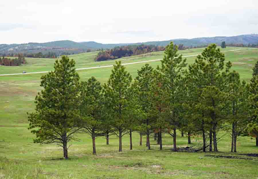
Photo taken of the area where the Cold Brook prescribed fire crossed US Highway 385, taken 39 days after the fire.
A preliminary report has been released for an accident that involved a firefighter who sustained a broken leg on July 20 and was extracted by short-haul the next day. This occurred on the Gregg Creek Fire in the Willamette National Forest east of Corvallis, Oregon. Earlier, the Linn County Sheriff’s Office issued a press release with some basic information, but on July 26 the Willamette National Forest, over the signature of Forest Supervisor Tracy Beck, filed a “72-Hour Preliminary Report” approximately 144 hours after the extraction.
Below is the narrative and a photo from the report:
****
“On July 20th, at approximately 2100 hours a Type Two IA crew was hiking off of the Gregg Creek Fire when a crewmember fell and sustained a lower leg injury. Crew EMT’s assessed the patient using the Medical Incident Report in the IRPG indicating “Priority-YELLOW (serious injury)”. The IC of the fire requested aerial extraction of the injured person though Eugene Interagency Dispatch (EICC). An additional 20 person hand crew, paramedics and overhead were dispatched to the incident to support medical evacuation operations while EICC pursued night time aerial extraction options. Both Oregon Air National Guard and United States Coast Guard were contacted for possible night time aerial extraction.
At 0303 hours on July 21st aerial extraction was attempted by the US Coast Guard without success due to excessive rotor wash creating additional hazards (ember showers and snags falling). Local cooperator Paramedics hiked in and were able to assist with patient care. A short-haul mission was ordered for first light.
At approximately 0830 hours short-haul operations were completed by a National Park Service short-haul capable helicopter which was prepositioned in the area due to fire activity. The patient was transported to a hospital and treated for a broken fibula and associated ankle injuries requiring surgery.”
****
On July 21, 2015 at Corvallis, Oregon a helicopter would have been permitted to begin flying at 5:18 a.m. PT, which was 30 minutes before sunrise.
Drones are increasingly becoming a very serious problem at fires in California. On Friday, July 17, five were reported near the North Fire — the “carmegeddon” fire that burned 22 vehicles trapped on Interstate 15 in southern California. Two drones, according to an agency spokesperson, actually gave chase to firefighting aircraft.
…All air units not only pulled back from the fire because of the drones, but all five were forced to touch back down at the airport in San Bernardino after jettisoning their loads, John Miller of the U.S. Forest Service said.
Five drones were initially spotted over the fire, which consumed five homes and more than a dozen cars as motorists frantically fled on foot through the Cajon Pass.
Two drones actually gave chase to air units, and the incident delayed response by about 15 to 20 minutes, according to Battalion Chief Marc Peebles of San Bernardino County Fire Department.
When asked if the delay contributed to the fire jumping the 15 Freeway, Peebles said “It definitely contributed to it.”
“At approximately 7:35 a.m. on July 12, a Stanislaus NF Type 3 engine was involved in a two vehicle collision which resulted in both vehicles rolling several times. The engine, on a cover assignment to the Sierra NF for lightning activity, was travelling east on Hwy 168, enroute to Prather Work Center for a briefing.
Responders from other Forest Service engines in the strike team, as well as CALFIRE, CHP and local EMS, were able to extricate the crew members and transport them to local hospitals. Three crew members sustained minor injuries, two of which were treated and released, while one crew member was held for observation overnight. The two more seriously injured crew members remain hospitalized in stable condition.
Hospital liaisons and patient advocates are in place supporting the firefighters and their families. A Peer Support Team as well as a Learning Review Team is in place. Upon completion, the final Facilitated Learning Review will be released thru the Wildland Lessons Learned center.
/s/ Kevin B. Elliott
Kevin B. Elliott
FLA Team Leader”