Senate holds hearing about powerline-caused wildfires

PG&E CEO says preemptive power shut offs during periods of high fire danger in California are likely to continue “for some period of time”

Witnesses at the Congressional hearing December 19, 2019
Witnesses at the Congressional hearing December 19, 2019. L to R: Bill Johnson (PG&E), Michael Wara (Stanford Woods Institute for the Environment), Scott Corwin (Northwest Public Power Association), Carl Imhoff (USFS Pacific Northwest National Laboratory), Dr. B. Don Russell (Texas A&M)

Today the U.S. Senate Committee on Energy and Natural Resources held a hearing to examine the impacts of wildfire on electric grid reliability, efforts to mitigate wildfire risk, and how to increase grid resiliency.

The five witnesses at the hearing were Bill Johnson (PG&E), Michael Wara (Stanford Woods Institute for the Environment), Scott Corwin (Northwest Public Power Association), Carl Imhoff (USFS Pacific Northwest National Laboratory), and Dr. B. Don Russell (Texas A&M).

The Senators and witnesses talked about Pacific Gas and Electric’s bankruptcy following the fires caused by their system, the future of preemptive power shutoffs during periods of high fire danger, and two new advances in technology that could help prevent some fires that are caused by power lines.

Dr. B. Don Russel, a professor at Texas A & M, told the committee about distribution fault anticipation technology developed at his university that uses intelligent algorithms to continually monitor electric circuits to detect the very earliest stages of failing devices and missed operations. The concept is simple, he said.  You find and fix it before the catastrophic failure causes a fire or an outage.  Dr.  Russel repeatedly advocated the adoption of this system.

San Diego Gas and Electric’s research found that it takes 1.37 seconds for a broken conductor to hit the ground, for example, if a tree falls into the line or a vehicle hits a power pole. When the line contacts the ground sparks can ignite vegetation. The system is designed to detect a break and shut off the power before the clock hits 1.37 seconds — hopefully, avoiding what could become a dangerous wildfire.
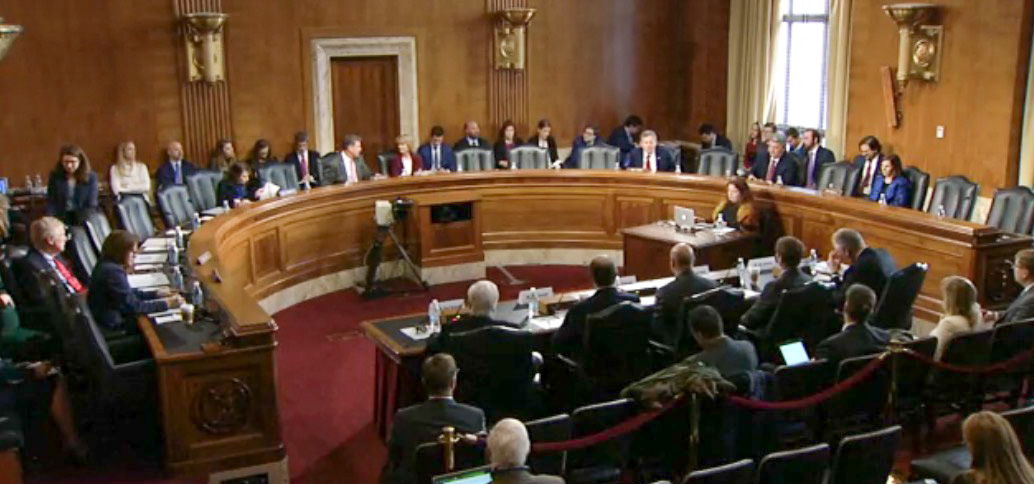
Hearing Senate power line fires
Screenshot from the video.

Bill Johnson became the CEO of Pacific Gas & Electric about 8 months ago about the time the company began going into bankruptcy. Senator Murkowski asked him how much longer residents in California would continue to be affected by the electricity being shut off during periods of high fire danger.

Mr. Johnson said San Diego Gas & Electric is still doing Public Safety Power Shutoffs (PSPS) in Southern California during periods of high fire danger 12 years after their power lines started multiple large fires in 2007, but the shutoffs are “surgical” and very localized. He said “[I]n Northern California it would take us probably five years to get to the point where we can largely eliminate this tool… So I think over the next couple of years you’ll see a progression of shorter, fewer PSPS events. But the climate change and the weather change is dramatic enough that I don’t think we will see the end of it for some period of time.”

Dr. Michael Wara discussed the effect of PSPS on residents:

The use of PSPSs has both prevented wildfire and caused widespread disruption to families and businesses, especially in Northern California. PSPS events, though they do dramatically improve safety, are likely very costly to the health of the economy, especially in smaller communities. My best estimate, using the Interruption Cost Estimator tool developed by Lawrence Berkeley Laboratory indicates that PG&E PSPS events in 2019 cost customers more than $10 billion – that’s 0.3% of gross state product or 10% of overall economic growth this year in California.

In October we wrote about the effects of PSPSs on California residents.

Below is an excerpt from Mr. Johnson’s prepared testimony about PG&E:

PG&E is deeply sorry for the role our equipment had in those fires and the losses that occurred because of them. And we’re taking action to prevent it ever happening again.

And today we’re taking that work a step further by increasing vegetation management in the high risk areas, incorporating analytical and predictive capabilities, and expanding the scope and intrusiveness of our inspection processes.

We deployed 600 weather stations and 130 high resolution cameras across our  service areas to bolster situational awareness and emergency response. We’re using satellite data and modeling techniques to predict wildfire spread and behavior. And we’re hardening our system in those areas where the fire threat is highest by installing stronger and more resilient poles and covered line, as well as undergrounding.

And this year we took the unprecedented step of intentionally turning off the power for safety during a string of severe wind events where we saw up to 100  mile an hour winds on shore in Northern California. And this decision affected millions of our customers,  caused them disruption and hardship even if it succeeded in protecting human life.

We are operating on all fronts to make the system safer and more resilient.

You can watch a video of the entire hearing. It is one hour and 35 minutes, not counting the wait for it to begin at 17:57.

New South Wales posts map showing predicted spread of bushfires

Comparing firefighting in North America and Australia

When a group of firefighters from North America arrived in Australia earlier this year to assist with an exceptionally large number of bushfires, one of them was quoted by a local media outlet as saying, “I understand it’s pretty traumatic for you guys, but it’s something we deal with – it’s our comfort zone”. It was not clear to whom the firefighter was speaking, civilians or in-country firefighters, but it struck me as a little odd and could be interpreted as patronizing from someone who had been in the country for less than a day.

Make no mistake, Australians have been dealing with vegetation fires as long as the North Americans have, and their blazes can be just as calamitous as those on the other side of the equator. Firefighters on both continents can learn from each other. From my limited vantage point 8,000 miles away it is clear that Aussies do a lot of things very well, especially designing their fire engines and keeping the public informed about  the status of active fires.

In the United States if a citizen needs current information about a wildfire how do they get it? The local sheriff, local fire department, or a state agency? It makes a difference about where to look if the fire is on federal land, state protected land, city, county, national or state park. If they try social media, what account? InciWeb sometimes has information about wildfires managed by federal agencies, but not all. Information about individual fires may not have been updated for 12 to 18 hours, however some incident management teams are better than others.NSW RFS Twitter And evacuations are managed by local law enforcement. When someone is threatened by a rapidly spreading wildfire they don’t have time to randomly check an alphabet soup of acronyms on dozens of web sites or social media accounts, even if they know the names, handles, or web addresses.

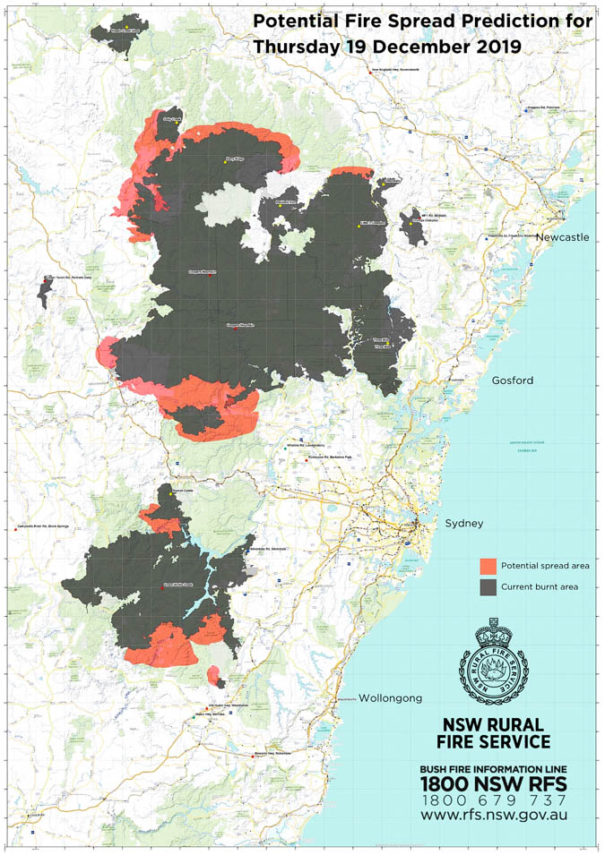
The map below is an example of something done very well in Australia. In New South Wales the Rural Fire Service distributes a great deal of current information to the public through Twitter, Facebook, and their web site.

NSW RFS fire spread projection map
From the NSW RFS:
Advice – Green Wattle Creek (Wollondilly LGA)
Extreme Fire Danger is forecast for this fireground on Thursday 19th December 2019. Conditions will be dangerous due to high temperatures, strong and gusty winds and low humidity. This potential fire spread prediction map shows the communities that may come under threat from embers or fire fronts. Conditions are then forecast to worsen again on Saturday.

It would be very unusual for a firefighting agency in the U.S. to distribute to the public a map, like the one above, that showed projections of fire spread of two major fires over the next 24 hours. Most agencies in the U.S. are hesitant to even publicly predict the general direction a fire will spread, let alone a map showing the location and extent of where the fire is expected to be in a matter of hours.

The technology to produce maps like this exists, but depending on the accuracy needed, it can require a supercomputer to crunch the numbers. In September the Orange County Fire Authority in California began a 150-day pilot program to use and evaluate the Fire Integrated Real-Time Intelligence System (FIRIS). It utilizes a supercomputer at the University of California San Diego running WIFIRE spread projections based on fire perimeter data collected by an aircraft. The output estimates where the fire will be in the next six hours. It has been run on real fires a few times, with the latest being the Cave Fire at Santa Barbara, California.

Another area where the NSW RFS excels is posting aerial videos of active fires. The agency frequently puts them on Twitter and Facebook, giving the public a general idea of how actively the fire is burning. Many of them show air tankers and helicopters dropping water on the fires, showing taxpayers how their money is being spent.

President and South Dakota Governor say Mount Rushmore July 4th fireworks will be restored

They were discontinued 10 years ago because of the danger of wildfires in the Ponderosa pine forest and poisoning of the water table from percholrate in the fireworks

fireworks Mount Rushmore Trump Noem
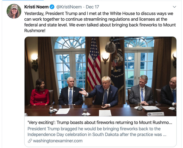
Part of the discussion December 16 at the White House was President Trump and SD Governor Kristi Noem stating that fireworks were going to be shot over Mount Rushmore July 4, 2020.

During a December 16 meeting in the White House with several Governors and administration officials, South Dakota Governor Kristi Noem and Mr. Trump both said fireworks were going to be displayed at Mount Rushmore National Memorial in South Dakota during the 4th of July holiday in 2020.

The fireworks were discontinued after 2009 due to wildfires that were ignited by the explosions over the Ponderosa Pine forest, and, very serious contamination of the water caused by the chemicals in the fireworks.

Below is a portion of the transcript of the meeting provided by the White House in which Mr. Trump said Governor Noem asked him for a “favor”.

THE PRESIDENT:  It’s a great place [South Dakota].  And you also are going to have a very exciting Fourth of July.

GOVERNOR NOEM:  We are.  We’re going to have fireworks.

THE PRESIDENT:  Right.

GOVERNOR NOEM:  And I’m hoping you will —

THE PRESIDENT:  For many years — for many years, the fireworks —

GOVERNOR NOEM:  — you will come — at Mount Rushmore.

THE PRESIDENT:  Well, we’re going to think about it.  Mount Rushmore.  They ended the fireworks.  How many years ago?  A long time.

GOVERNOR NOEM:  Gosh, it was at least 10 years ago.  So —

THE PRESIDENT:  Nobody knows why, but you just couldn’t have it.  And now you’re going to have fireworks.  And the Governor called, and she said, “You got to do me a favor.”  Right?

GOVERNOR NOEM:  And you did.

THE PRESIDENT:  And we worked it out.  And we got it done.  And you’re going to have fireworks.

In May, 2019 both the Governor and the President issued statements or tweets saying the fireworks were being restored.

President Trump, May 8, 2019:

I am pleased to inform you that THE BIG FIREWORKS, after many years of not having any, are coming back to beautiful Mount Rushmore in South Dakota. Great work @GovKristiNoem and @SecBernhardt! #MAGA

Governor Kristi Noem also distributed a press release, writing in part, “[T]he State of South Dakota and the U.S. Department of the Interior have agreed to bring fireworks back to Mount Rushmore National Memorial beginning with the 2020 Independence Day celebration.”

The Memorial is administered by the National Park Service which is part of the Department of the Interior. The DOI signed a Memorandum of Agreement with the State of South Dakota, “to work to reinstate fireworks at Mount Rushmore for Fourth of July celebrations.”

Following the May announcements by the politicians, the NPS said it was not etched in stone that the fireworks would occur.

“The agreement”, said Maureen McGee-Ballinger, chief of interpretation and education at Mount Rushmore, “is the first step in a long process. The National Park Service will be working with the state, land management agencies, various specialists in a variety of fields, and will be exercising our authority under state and federal law to explore safe and available options in regards to the proposal. So, it’s a proposal. This is just the beginning of the process to look at that.”

Today we checked with the NPS again and a spokesperson in Washington said, “The National Park Service has not made a formal decision; that will happen through the [National Environmental Policy Act] and permitting processes. The NPS expects to release a NEPA document for public review in February, 2020.”

So, officially, no decision about Mount Rushmore fireworks has been made, in spite of the statements by the President and the Governor to the contrary. The word in D.C. is that the fireworks are a priority, so how would you place a bet? They will or will not happen?

During the first five years of the fireworks, Mount Rushmore was one of the seven Parks within the Northern Great Plains Fire Management organization for which I was the Fire Management Officer.

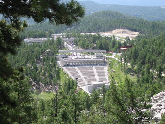
Mount Rushmore looking down from the top
Mount Rushmore administrative site, looking down from the top of the sculpture. Photo by Bill Gabbert June, 2001.

The park is not just the stone carving; it is surrounded by thousands of acres of timber and the Black Hills National Forest.

Part of my job was to plan for suppression of the fires that started when burning embers from the fireworks hit the ground. We mobilized dozens of firefighters during the busy part of the fire season and had them positioned just outside the falling-debris zone. We had to restrict out of area fire assignments to be sure enough firefighters remained available for the show. After the aerial explosions ended, we would move in, search at night in the steep rocky terrain, and extinguish the fires.

In one of the first displays over a dozen fires started. They were all put out when they were small, but it was proven then to be an insane concept to shoot off literally tons of fireworks over a ponderosa pine forest in July.

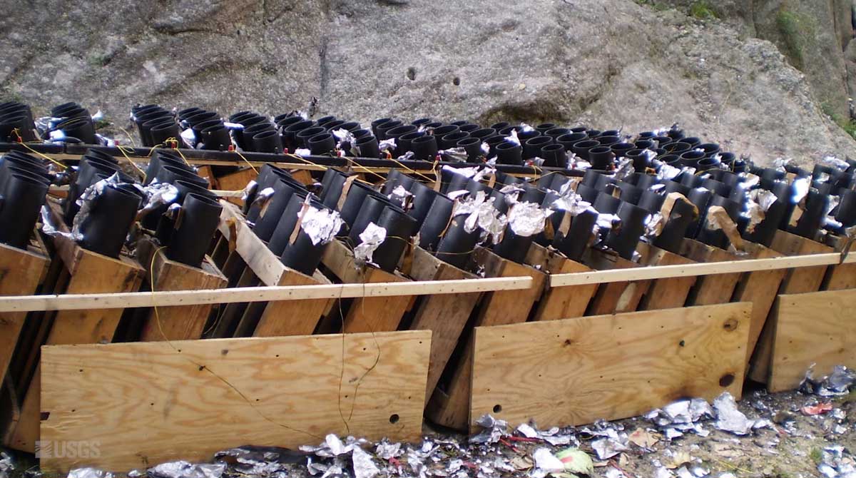
Mount Rushmore fireworks debris
Some of the debris and trash at the launch site of the fireworks at Mount Rushmore.

The shows left on the sculpture and in the forest unexploded shells, wadding, ash, pieces of the devices, paper, and poisonous chemicals; stuff that can never be completely picked up in the steep, rocky, rugged terrain.

In 2016 the USGS discovered that the ground and surface water at Mount Rushmore is contaminated with percholrate, a component of rocket fuels and explosives. They determined that the chemical came from the fireworks over that 12-year period.

Data from the USGS report showed that a maximum perchlorate concentration of 54 micrograms per liter was measured in a stream sample, which is about 270 times higher than that in samples collected from sites outside the memorial. The Centers for Disease Control says high levels of perchlorates can affect the thyroid gland, which in turn can alter the function of many organs in the body. The fetus and young children can be especially susceptible.

The battle over California’s eucalyptus trees

The invasive plant increases the fire hazard in urban and rural areas

Eucalyptus fire wildfire
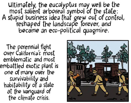
One in a series of The Guardian graphics about the hazards of eucalyptus trees in a fire prone environment.

Many areas around the world have imported eucalyptus trees in order to harvest the wood, leaves, and oil in order to make paper and medicine. But wildfires burn rapidly under the trees and through the crowns, fed by the stringy bark, oil, and the leaves and forest litter on the ground that do not decompose.

In California they have also been imported and planted for esthetic purposes. But this invasive species brought many problems with it.

The Guardian has a unique illustrated story about this controversial plant. Check it out here.

Articles on Wildfire Today tagged “eucalyptus“.

DHS studies emerging technology for wildfire response

The project team evaluated over 60 systems

DHS study wildfire technologyIn December of 2017, the Federal Emergency Management Agency Administrator requested the Department of Homeland Security Science and Technology research new and emerging technology that could be applied to wildland fire incident response, given the loss of life that occurred in California during the fall of 2017 in Santa Rosa and Ventura.

The project team identified three overarching conclusions that represent consistent themes captured throughout the course of the table top exercises and expert engagements.

  1. Time Criticality of WUI Fire Incidents: WUI fire incidents require immediate protective and response actions to save lives. The conflagration created when a wildland fire enters populated areas is unpredictable and can rapidly devastate these areas, threatening lives. Interventions and solutions that improve decision making and response in the initial minutes of a WUI fire are vital.
  2. Available Technology Solutions Exist: There exist available technologies (both government and commercial), which—if implemented—could immediately help emergency responders reduce the number of lives lost during WUI fire incidents. In particular, these technologies could immediately support ignition detection, fire tracking, public information and warning, evacuation, and responder safety. Improving capabilities in other elements of the WUI response (i.e. preparedness and critical infrastructure) may require investing in adaptable or developable solutions that are not immediately available.
  3. Public Education and Preparedness Measures are Vital: Public education and preparedness are essential to reducing the number of lives lost to WUI fire incidents. There is no solution more effective than preventing an ignition in the first place and ensuring the at-risk communities are prepared at the grassroots level to face wildland fire dangers.

The principal conclusions of this project are distilled into a set of seven key findings. They describe lines of effort addressing priority capability gaps that, if implemented, could substantially improve immediate life-saving efforts during WUI fire incidents. The key findings listed below are considered equally important to this objective and are not listed in any priority order.

  1. Implement and scale the use of state-of-the-art remote sensing assets to provide state and local stakeholders real-time, accurate, low-cost ignition detection and tracking information— especially fire perimeter using a mix of in situ, aerial, and space-based systems.
  2. Improve the ability of available and adaptable public alert and warning technologies to deliver more targeted and effective message across the whole community, particularly to individuals with disabilities and others with Access and Functional Needs (AFN).
  3. Improve use of key public and private social media and internet resources and capabilities to appropriately share data and adapt existing applications to enable more efficient and effective evacuation—e.g., expand and accelerate public-private partnerships through Integrated Public Alert and Warnings System (IPAWS) to include WUI incident-related evacuations, warning, and alerting.
  4. Support broader use of existing fire modeling and forecasting tools for pre-incident planning; while also advancing efforts to create high-confidence, timely WUI fire-specific models that can be used to inform response tactics during extreme conditions.
  5. Increase infrastructure resilience, especially critical infrastructure lifelines and support functions for wildland fire response—e.g., improve the resilience, interoperability, and reliability of communications, power utilities, digital links, and data center infrastructure.
  6. Integrate private, open, and crowdsourced data, resources, and capabilities to improve public safety situational awareness of WUI fire ignition detection and tracking.
  7. Support wide-scale adoption of interoperable, low-cost blue-force tracking technologies that feed near real-time situational awareness across key stakeholders, missions, and operations.

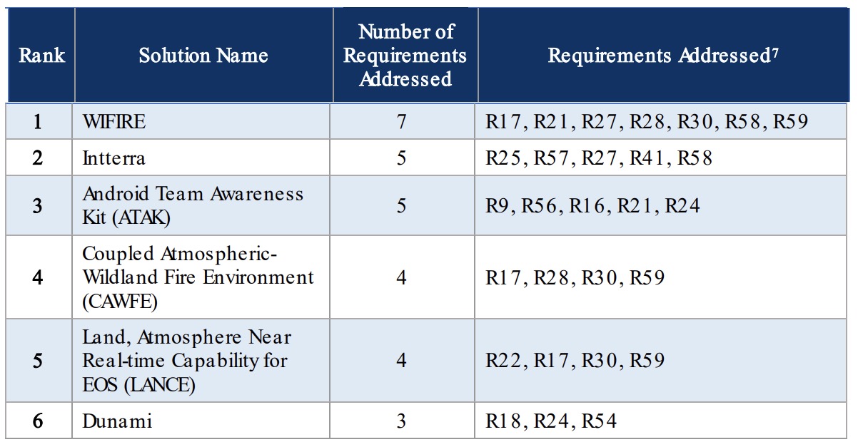
The project team evaluated over 60 existing systems, products, or solutions. Here is an example of how 10 were ranked for how well they addressed requirements.

technology address wildfire management safety

technology address wildfire management safety
Top ten solutions based on how many requirements that solution addresses.

In addition, the team evaluated the solutions for feasibility, affordability, usability, impact, and technology alignment.

The entire 131-page report can be downloaded. 2.8 MB

Thanks and a tip of the hat go out to LM. Typos or errors, report them HERE.

NWCG changes standards for crews and dozers

Rose Fire Lake Elsinore CA
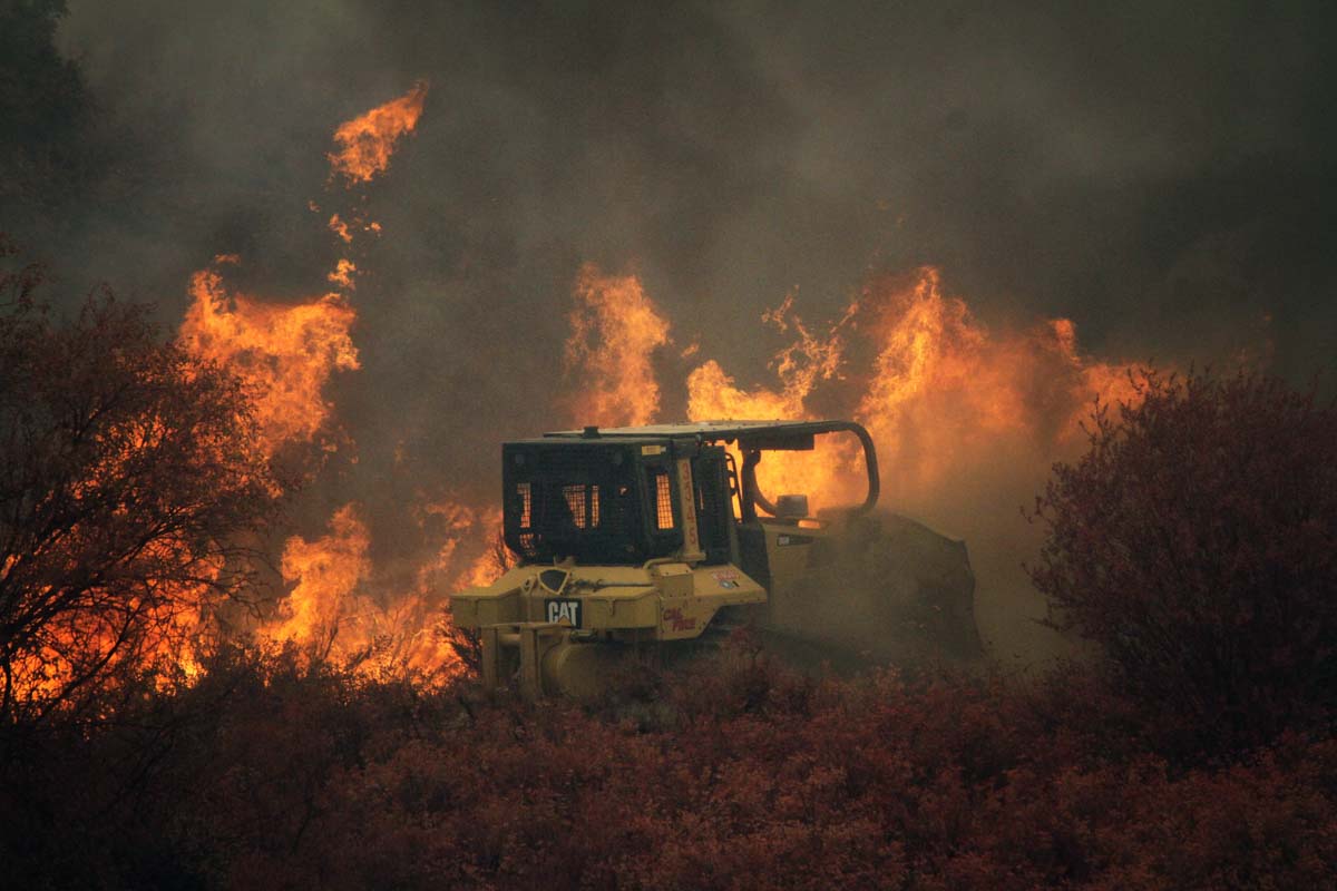
A dozer constructs fireline on the Rose Fire near Lake Elsinore, California, July 31, 2017 Photo by Jeff Zimmerman.

Over the last five years the National Wildfire Coordinating Group has made revisions to the standards for hand crews and dozers

The NWCG establishes standards for the capabilities of firefighting aircraft, crews, and equipment. For example, a Type 1 Engine must carry 1,200 feet of 2.5″ hose and have a pump capability of 1,000 gallons per minute, while a Type 6 Engine needs to have 300 feet of 1.5″ hose and a 50 GPM pump.

There were a handful of changes made to the standards that were published in 2014.

CREWS
The number of personnel on a Type 1 Crew was increased from 18 to 20, to 18 to 22. There were a couple of new position qualification requirements for leadership on crews. The new standard:

Permanent supervision:
Superintendent: TFLD, ICT4, FIRB
Asst. Supt.: STCR or TFLD and CRWB and ICT4
3 Squad Leaders: CRWB and ICT5
2 Senior Firefighters: FFT1

In 2014 Type 1 Crews only had to have three “agency-qualified” sawyers. Now there must be four certified Intermediate Fallers (FAL2) and 50 percent of the crew needs to be qualified as Basic Faller (FAL3).

The number of programmable radios on a Type 1 Crew was increased from five to eight.

DOZERS
There were major changes for dozers. The horsepower was increased for all types, a fourth type was added, and minimum base weights were established.

New requirements dozers
New requirements for dozers, December, 2019. NWCG.

UNMANNED AERIAL SYSTEMS
This category was added to account for the sudden increase during the last two years in the number of UAS, or drones, now being used on many types of incidents. More information is at Fire Aviation.

AIR TANKERS
An additional type of air tanker has been added since 2014 — the Very Large Air Tanker which is required to have a capacity of at least 8,000 gallons.

I did not notice any significant changes in the requirements for helicopters, engines, water tenders, or Type 2 crews.

The NWCG Standards for Wildland Fire Resource Typing can be accessed here.