69 homes believed destroyed in New South Wales bushfire

Above: A fire burns structures in Tathra, New South Wales. Photo credit: NSW Rural Fire Service.

(Updated at 8:30 a.m. MDT March 19, 2018, US time)

At least 69 homes were destroyed and 39 damaged in the bushfire that spread into the coastal community of Tathra in New South Wales according to the Rural Fire Service.

As the fire ran into the town many residents took refuge on the beach, but very strong winds, smoke, and blowing sand convinced some to leave and head for the evacuation center in Bega.

The fire has burned approximately 1,200 hectares (2,965 acres).
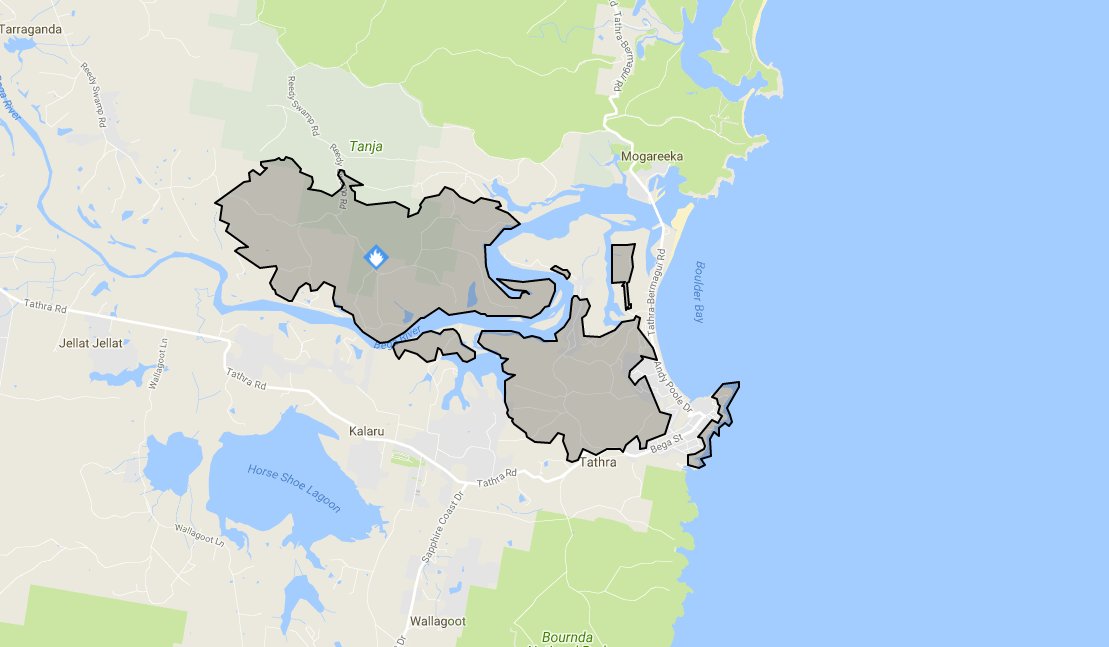
map fire tathra
Map of the fire near Tathra, New South Wales. NSW RFS.


(Originally published at 11:03 a.m. MDT March 18, 2018, US time)

A fire that started southeast of Bega, New South Wales has burned east to the Pacific coast destroying homes in its path. The official tally of the affected structures is not available but Campbell Fuller, communications director of the Insurance Council of Australia, said “We are hearing several dozen properties” burned.
map bushfire Tathra new south wales
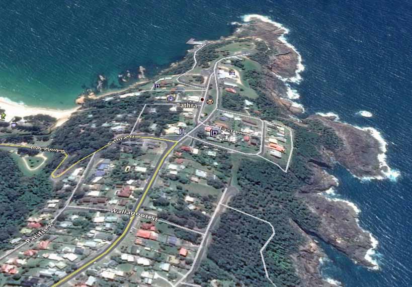
Google Earth file photo of the area in Tathra NSW affected by a bushfire. Compare this image to the one at the top of the article.

From the Daily Telegraph:

Earlier on Sunday night Bega Valley Shire Council mayor Kristy McBain said up to 35 homes had been lost and the concern was now about people stuck in Tathra as the roads in and out of the town were closed.

Many of the destroyed homes were in the small coastal community of Tathra, population 1,622. After the fire ran east for 5 miles (8 km) from the Bega area to the coast, jumping the Bega River, the wind shifted to come out of the south, slowing the spread. Officials advised residents to continue to monitor conditions and be prepared to enact their bush fire survival plan should the fire threaten again. The evacuation center is at Bega Showground.
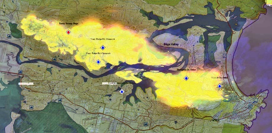
map bushfire Tathra new south wales
Map of the bushfire between Bega and Tathra NSW. Map by NSW RFS.

The NSW Rural Fire Service video below shows Air Tanker 390 making a drop in Tathra.

The latest size of the fire released by the Rural Fire service at 23:10 March 18 local time was 1,000 hectares (2,470 acres).


bushfire Tathra new south wales
Air Tanker 390 makes a retardant drop near structures in Tathra, NSW. Photo credit, NSW RFS.


Elevated wildfire danger for the next 9 days in portions of CO, NM, TX, OK

Low humidities and frequent strong winds will challenge firefighters

Above: National Weather Service product for the Tucumcari, New Mexico area showing peak wind gusts and the potential for fire spread, March 17 through 25.

Originally published at 11:10 a.m. MDT March 17, 2018.

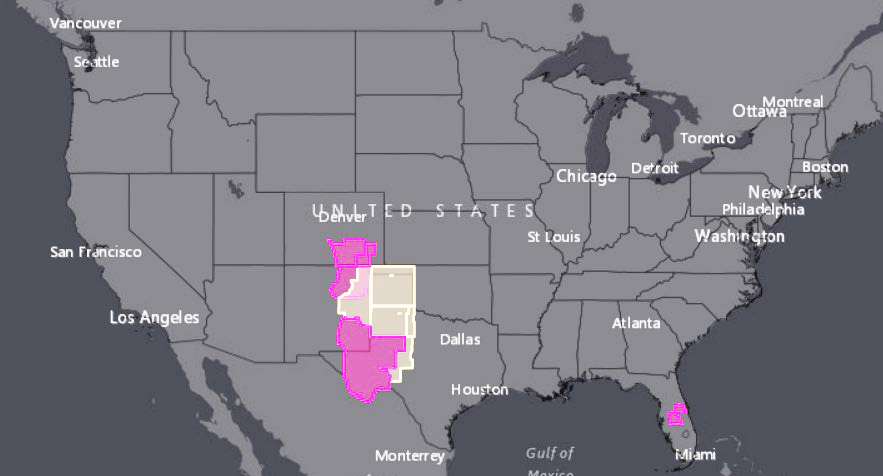
Firefighters could be busy for the next 9 days in portions of Southeast Colorado, Eastern New Mexico, the panhandle of Oklahoma, and Western Texas. The period begins Saturday with Red Flag Warnings in those areas for strong winds and low humidity. The pattern will continue off and on, mostly on, through the next weekend, March 25.

Red Flag Warnings wildfire
Red Flag Warnings (red) and Fire Weather Watches (yellow), March 17, 2018

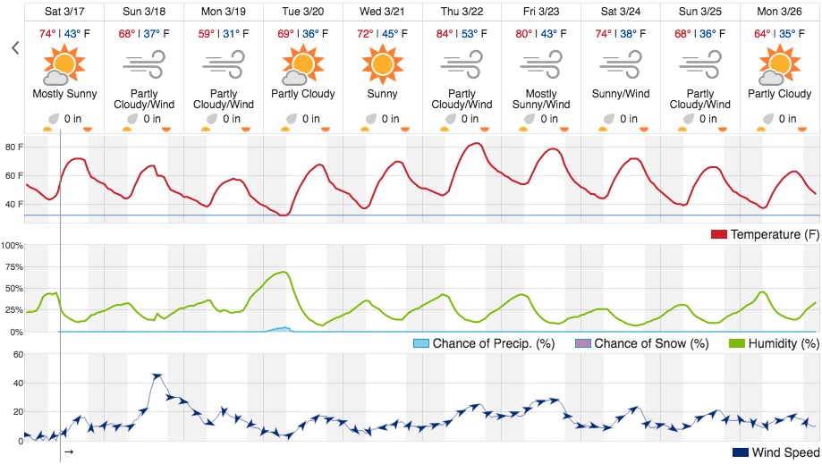
The National Weather Service chart at the top of this article shows what models predict for potential fire spread in the Tucumcari, New Mexico area, which is just outside of the Red Flag Warning for today, Saturday. It is almost a certainty that the predicted 50 mph wind gusts for Tucumcari on Sunday will generate a Red Flag Warning. Below is the Weather Underground product for the same area, which is a 4,200 feet above sea level. It shows minimum relative humidities that are in the low teens for every day through March 26 with the exception of Monday March 19 when it bottoms out at 22 percent, still quite low. Strong winds are in the forecast for Sunday, Monday, and Thursday through Sunday.

Weather forecast Tucumcari NM
Weather forecast for Tucumcari, NM. Weather Underground.

Wildfire starts on Colorado military post, burns 2,100 acres

The Carson Midway Fire burned hundreds of acres in Colorado Friday, March 16, 2018. Photo credit: Tri-Lakes Monument Fire Protection District

Evacuations remained in place Friday night and several structures reportedly burned after a fire broke out on a Colorado military post and spread to surrounding areas, officials said. 

The fire, which started midday Friday in the southeastern portion of Fort Carson’s training area, burned approximately 2,100 acres in Pueblo and El Paso counties — on and off the Army post — by Friday night, according to the Pueblo County Sheriff’s Office. 

Firefighters from Fort Carson, near Colorado Springs, in conjunction with El Paso and Pueblo county agencies worked the Carson Midway Fire through the day Friday.

Air resources from Fort Carson worked with Bambi Buckets to assist fire fighters on the ground, officials said. Additional fixed-wing air assets have been requested and are on scene.

Approximately 100 Pueblo County residents living in the Midway Ranch area were evacuated. A large-animal shelter was also established at the Colorado State Fairgrounds.

The cause of the fire is under investigation.

Additional details about the number of structures affected were not immediately available.

Red flag warnings were issued across the region Friday. Gusty, dry conditions are forecast to return Saturday, according to the National Weather Service.

Red Flag Warnings in seven states, March 16, 2018

The National Weather Service has issued Red Flag Warnings and/or Fire Weather Watches for areas in Colorado, Kansas, New Mexico, Oklahoma, Texas, Arkansas, and Missouri.

The Red Flag Warning map was current as of 9:52 a.m. PDT on Friday. Red Flag Warnings can change throughout the day as the National Weather Service offices around the country update and revise their forecasts.

‘Catastrophic fire conditions’ possible today as Kansas blazes continue

Fires raced through grasslands in Kansas this week, drawing the National Guard, which captured this photo.

A series of wildfires have burned thousands of acres of grasslands in Kansas this week, and while relief might be in sight, there’s still a full day of volatile conditions ahead, officials say.

“Friday will be a very dangerous day for fire weather in many areas of the state. Some areas will see catastrophic fire weather conditions,” the Kansas Division of Emergency Management said.

Most of the state is under red flag or high wind warnings with forecast to gusts up to 40 mph in some areas Friday. Temperatures around 70 degrees are expected to drop into the 50s this weekend, with rain in the forecast, according to the National Weather Service.

Fires erupted Wednesday. Kansas Gov. Jeff Colyer made an emergency declaration for three of the fires burning in Rice County and deployed Black Hawk helicopters from the Kansas National Guard to assist in the response.

According to The Wichita Eagle, state officials tracked 45 fires across the state on Thursday alone, with several breaking out in the Kansas City area. The fires burned an estimated 13,000 acres, and many remained active or out of control.

More detailed assessments of acreage or causes were not immediately available.

About 20 percent of the state is classified as being under an “extreme drought,” according to the latest report from the U.S. Drought Monitor.

NOAA report: Warmer-than-average spring, worsening drought across West

Above: Areas of the United States where the average temperature for April-June 2018 is favored to be in the upper (reddish colors) or lower (blue colors) third of the 1981-2010 seasonal temperature record. Within a given area, the intensity of the colors indicates higher or lower chances for a warm or a cool outcome, not bigger or smaller anomalies. For example, both Texas and Tennessee face better than even chances of experiencing well above average spring temperatures, but the chances are higher in Texas (60-70%) than in Tennessee (40-50%). NOAA Climate.gov map, based on data from NOAA CPC. Photo credit: NOAA

Spring is likely to be warmer than the historical normal this year in much of the country with a worsening drought situation across swaths of the West, according to the latest report from the National Oceanic and Atmospheric Administration.

The report, issued Thursday, encompasses April-June.

The Northern Rockies is the only region leaning toward below-average temperatures this spring, forecasters said.

In addition to increased probabilities of warmer temperatures across much of the U.S. — and especially the Southwest — the outlook suggests drought is likely to develop or worsen in Southern California, Arizona, New Mexico and part of Utah, Colorado and Kansas.

“It appears La Nina is on its last legs,” said Mike Halpert, with the Climate Prediction Center. “As sea surface temperature anomalies weaken, their influence on springtime temperature and precipitation should also weaken.”

Drought is likely to worsen or develop across much of the Southwest quadrant of the contiguous United States this spring. Pockets of drought are predicted to continue in the Southeast and Oregon.  Map by NOAA Climate.gov, based on data from the Climate Prediction Center.
Drought is likely to worsen or develop across much of the Southwest quadrant of the contiguous United States this spring. Pockets of drought are predicted to continue in the Southeast and Oregon. Map by NOAA Climate.gov, based on data from the Climate Prediction Center.

The outlook also noted a moderate risk of flooding in the Ohio River Valley basin and lower Mississippi River where streamflows and soil moisture are above normal after recent heavy rain.