More information available about BLM Programmatic EIS

Above: BLM map for the programmatic fuel management EIS. The cross-hatched area identifies the Project Boundary. The small dots near the names of cities identifies the locations of Scoping Meetings.

(Originally published at 1:30 p.m. MST January 11, 2017)

When the Bureau of Land Management announced on December 22 the agency was going to write two blanket Programmatic Environmental Impact Statements to streamline fuel treatment projects in much of the Western United States, the web site they referred the public to for more information had zero information. This presented a problem since the since the deadline to comment was initially February 20. After we inquired on January 2 about where interested citizens could find out what the BLM planned to do, we heard back from them today, January 11, saying they have now posted some information at the site.

BLM fuel break
BLM fuel break. BLM photo.

We checked and found the map shown at the top of this article. There is also a Notice of Intent, Bulletin, and a list of public meetings.

The agency is proposing to develop two Programmatic Environmental Impact Statements for BLM lands in the states of Idaho, Oregon, Nevada, California, Utah, and Washington. One will cover the construction of fuel breaks while the other is for fuels reduction and rangeland restoration.

Now that they have a schedule for public meetings which runs through February 15, the deadline for comments has been extended to February 28.

The blanket approval will mean that individual landscape-scale fuel breaks and fuel reduction proposals will only need minor additional environmental reviews to proceed.

Fuel breaks are intended to interrupt the continuity of vegetation making it easier to control or stop the spread of wildfires.  They can be created manually by hand crews and mechanized equipment, or through the use of herbicides. There is no guarantee of success since wind-blown burning embers can be lofted hundreds or thousands of feet ahead of a flaming front, crossing the breaks.

Former firefighter convicted second time for arson

The ex-firefighter started 20 fires in 2013 and another in 2016

James Frederick Maw
James Maw

(Originally published at 12:40 p.m. MST January 11, 2018)

Five months after a former seasonal Montana wildland firefighter was given a 40-year suspended sentence for starting 20 wildfires in 2013, he lit another fire in 2016 that burned about an acre on the ranch where he was working.

James Frederick Maw started the first batch of fires in May, 2013. Five of them near York, Montana were managed as the Sweats Complex, with the total number of acres burned listed at 450 with 225 personnel assigned when we reported on the fires and the arrest May 17, 2013. The series of fires in 2013 in the Priest Pass, Spokane Hills, and York areas caused almost $1 million in damages.

The Missoulian reported:

He was arrested [in 2013] in the York-Nelson area in full firefighting gear holding a trigger-operated lighter. He initially said he was a contract firefighter but confessed to starting the fires because he enjoyed the camaraderie of firefighting and needed the financial payoff from fighting fires.

Due to Mr. Maw’s mental health issues his 40-year sentence was suspended by Judge Katherine Seeley.

Below is an excerpt from MTN published November 2, 2015 about the sentencing hearing for the 2013 fires:

However, Lewis & Clark County Attorney Leo Gallagher and Broadwater County Attorney Corey Swanson told the court that due to the severity of the crimes — 14 arson fires set in May of 2013 in both counties — require some form of incarceration.

“He threatened the lives of the firefighters in this community,” said Gallagher. “People with homes that were in harm’s way out there, and I just think there needs to be a consequence, your honor, beyond just probation.”

The fire service community also called for prison time.

“Mr. Maw’s statement and his memory lapses give no indication he is either sorry for the lives he put at risk or taking responsibility for his actions,” said Chief [Jordan Alexander of Baxendale Fire].

While still on probation for arson, in April 2016 Mr. Maw was arrested for starting the fire on the ranch. He told investigators the chain saw he was using hit a rock, creating a spark which ignited the fire, but his story did not match the facts uncovered.

After delays for another mental health evaluation, on January 8, 2018 the same judge, Katherine Seeley, sentenced him to 35 years in prison.

Pyrocumulonimbus clouds

Above: Bureau of Meteorology, Australia

(Originally published at 11:38 a.m. MST January 11, 2017)

The Australian Government’s Bureau of Meteorology has an excellent article about clouds that can form over rapidly burning vegetation fires. Pyrocumulus clouds can develop into pyrocumulonimbus that can generate lightning miles away from the fire.  Below are excerpts from the article.


What are pyrocumulonimbus clouds?

They’re a thunderstorm that forms in the smoke plume of a fire (or nuclear bomb blast, or volcanic ash cloud). In Australia they most commonly form in large and intense bushfire smoke plumes. (The official name for clouds that form this way is ‘flammagenitus‘, but they’re commonly known as pyrocumulonimbus.)

How do they form?

The intense heat from the fire causes air to rise rapidly in the smoke plume. The rising hot air is turbulent and draws in cooler air from outside the plume, which helps cool the plume as it rises. As the plume rises to higher and higher elevations the atmospheric pressure reduces, causing the plume air to expand and cool even further. If it cools enough, the moisture in the plume air will condense and forms cumulus cloud, which, because it comes from the fire plume, we call ‘pyrocumulus’. The condensation process causes latent heat to be released, which makes the cloud warmer and more buoyant and causes the cloud air to accelerate upwards. Further expansion and cooling causes more moisture to condense and the cloud air to accelerate upwards even more. In the right conditions the cloud can accelerate into the lower stratosphere before losing buoyancy. Collisions of ice particles in the very cold upper parts of these clouds cause a build-up of electrical charge, which is released by giant sparks—lightning. Having produced a thunderstorm, the cloud is now known as ‘pyrocumulonimbus’.

TBT: new wildfire terminology

For Throwback Thursday, here’s what we wrote on April 1, 2009:


On the Daily Show last night there was much lampooning of the Obama Administration’s “rebranding” of the “War on Terror” into the new term they want to use:  “Overseas Contingency Operation”.  Really. Seriously.

And taking that several steps further, John Oliver said other rebranding plans for the Administration will include:

  • Flooding in North Dakota will become: Semi-Voluntary Property Baptism
  • Obesity Epidemic will become: Enhanced Biological Jollification

And my favorite:

  • Forest Fires will become: Extreme Wildlife Oxification and Talking Bear Employment Opportunities

Oliver then did a (poor) impression in his English accent of Smokey saying:  “Only You, Kids, Can Prevent Extreme Wildlife Oxification”.

Jon Stewart:  “Obviously you didn’t have Smokey Bear in England.”

Oliver: “No, Jon, we just let our forests burn.”

Nearly a record breaking year for acres burned in the U.S.

Wildfires consumed 9.7 million acres in the United States in 2017

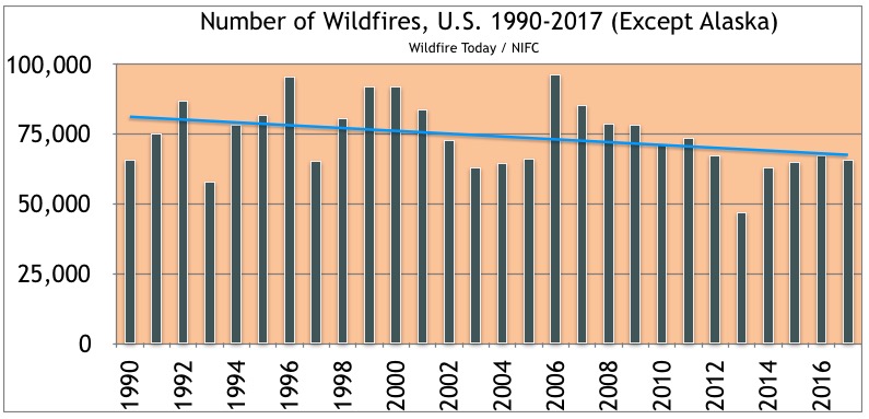
It will probably not come as a surprise to many, but the number of acres burned in the United States in 2017 came close to breaking a record. The numbers are preliminary and could change over the next few weeks as the data is finalized but the acres burned in the 50 states, 9,781,062, was the second highest since reliable records have been kept. That is 49 percent higher than the average over the last 10 years. Even as the trend line for the acres burned has increased dramatically since 1990 the total number of fires has generally been slowly decreasing. In 2017, 66,131 fires were reported, which was 4 percent lower than the 10-year average.


number of wildfires United States 1990-2017

But to look at the big picture, at Wildfire Today we like to analyze the national trends without the stats from Alaska, and there are two reasons why. Fires in that huge state are managed far differently from the other 49 states. Most of them are not fully suppressed since they are less likely to endanger people or private property than in the lower 49 states. The second reason is that the fire occurrence is extremely variable, with the acres burned since 1990 ranging, for example, from 43,965 acres in 1995 to 6,645,978 in 2004. Including the Alaska numbers would skew the data for the other 49 states making it more difficult to spot trends.

In case you are wondering why our charts only go back as far as 1990, we are not convinced that the information before that is reliable. In the data provided by the National Interagency Fire Center there was a very sudden, long lasting major shift in the numbers beginning in the early 1980s.

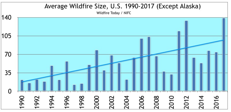
The sloping horizontal lines in the charts represent the statistical linear trend.

average size acres wildfires United States 1990-2017

A statistic that is quite interesting is the average size. The linear trend line starts at about 22 acres in 1990 and reaches close to 100 acres by 2017. In fact, the average size in 2017 was 139 acres. There could be a number of reasons for this huge increase:

  • Weather that is warmer and drier making fires more difficult to suppress.
  • One hundred years of fire suppression has led to forests that are more dense and fires that burn with greater intensity.
  • A less aggressive strategy is being used on large fires more often for safety reasons.
  • More fires are allowed to burn naturally without full suppression for environmental concerns.
  • There may have been a change in the initial attack of new fires, responding with less equipment and personnel.

Another factor to consider is that there was a gradual 30 to 70 percent reduction in the number of large air tankers on exclusive use contracts from 2002 until 2014 when the fleet began to be partially restored.

Images from mud flows and flooding in Southern California

We spent a few minutes on Twitter Tuesday evening looking for information about the impacts of the very heavy rain northwest of Los Angeles over the last 24 hours. The freshly barren burned hills above some of these areas contributed to the extraordinary amount of water and debris transported into the communities.