Goodwin Fire crosses Highway 69 at Mayer, grows to 20,000 acres

Above: 3-D map of the Goodwin Fire at 9 p.m. MDT June 27, 2017.

(Originally published at 7:04 a.m. MDT June 28, 2017)
(Updated at 11:45 a.m. MDT June 28, 2017)

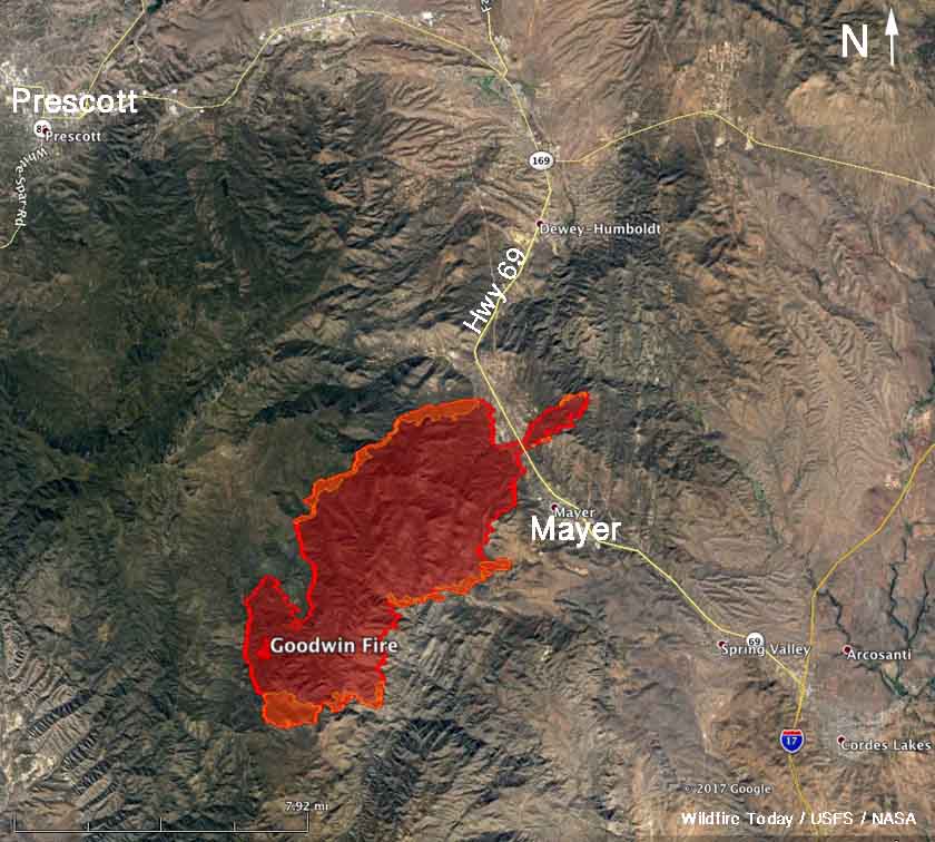
Wednesday morning the Goodwin fire was five times larger than it was 24 hours earlier. Southwest winds and low humidities caused it to spread to the northeast threatening the town of Mayer, Arizona which was under a mandatory evacuation order. It crossed highway 69 just north of the town and as of 9 p.m. Tuesday had spread for another two miles east of the highway, growing to about 20,600 acres. The previous night it was at 4,400 acres and had expanded to about 12,000 acres by 2:40 p.m. Tuesday.

The weather forecast for Wednesday is not good news for firefighters. The outlook is for 93 degrees, 11 percent relative humidity, and by noon the wind should increase to 12 to 15 mph out of the south to southwest with gusts to 27.

At a media briefing Wednesday at 11:20 a.m., Incident Commander John Pierson said an area of fuel mitigation completed by the state of Arizona north of Mayer was instrumental in helping to protect the town as the fire ran across Highway 69. He also said there is a good chance the portion of the fire that is east of the Highway can be contained by the dozers and hand crews that are working in that area.

On Wednesday air tankers began dropping retardant on the fire at 8 a.m. There are no ground troops in those locations to follow up and construct firelines, so the best firefighters can hope for, Mr. Pierson said, is that the spread of the fire will be slowed or delayed.

While the fire was making its big run Tuesday, a weather station at Sunset Point 14 miles southeast of the fire recorded a temperature of 101 degrees, 3 percent relative humidity, and 11 to 15 mph winds out of the south to southwest winds gusting at 23 to 31 mph.
map Goodwin Fire
Map of the Goodwin Fire at 9 p.m. MDT June 27, 2017.

Highway 69 is closed at Mayer. Evacuations are in effect for several communities in the area.

The National Situation Report says nine structures have burned since the fire started, but it is unclear when or where that occurred. There are no reports yet of any structures being destroyed as the fire approached Mayer. A June 27 news release from the Incident Management Team includes this information:

Goodwin Fire managers and cooperators have been receiving inquiries regarding structures damaged or destroyed during the first day of Goodwin Fire. It was reported that structures have been destroyed and the Yavapai County Sheriff’s Office personnel are working with fire officials to determine the extent of damaged structures. However, this can only be accomplished when it is safe for deputies to enter, complete an accurate assessment, and determine ownership. Efforts to expedite the release of such information is ongoing. In the meantime, the patience of those residents who have been evacuated is greatly appreciated.

Beth Lund’s Type 1 Incident Management Team which had been staged at Phoenix has been ordered for the fire. They will be working with John Pierson’s Type 1 Incident Management Team that is already there.

In the video below, smoke from the Goodwin Fire can be seen in the lower-left corner. The other fire to the north is the Brian Head Fire east of Cedar City, Utah.

All articles on Wildfire Today about the Goodwin Fire near Mayer, Arizona.

Goodwin Fire forces evacuation of Mayer, Arizona

Above: The map shows the approximate location of the Goodwin Fire at 2:40 pm MDT, June 27, 2017. The data was supplied by a NOAA satellite and is a very rough estimate.

(UPDATED at 8:31 p.m. MDT June 27, 2017)
(Originally published at 5:57 p.m. MDT June 27, 2017)

The spread of the Goodwin Fire toward Highway 69 and Mayer, Arizona forced the mandatory evacuation Tuesday afternoon of the entire town and its 928 residents. The community of Pine Flat was previously evacuated.

According to satellite data we acquired at 2:40 p.m. MDT on Tuesday, at that time the Goodwin Fire was 12 miles southeast of Prescott, 1 mile west of Mayer, and 6 miles southwest of Dewey-Humboldt. According to the data, the fire has burned approximately 13,000 acres —  that is a VERY unofficial estimate, three times the size determined by an infrared mapping flight Monday night, which was 4,400 acres. Consider the 13,000 acre figure preliminary and a very rough estimate until the next mapping flight Tuesday night.

smoke Goodwinda and Brian Head Fires
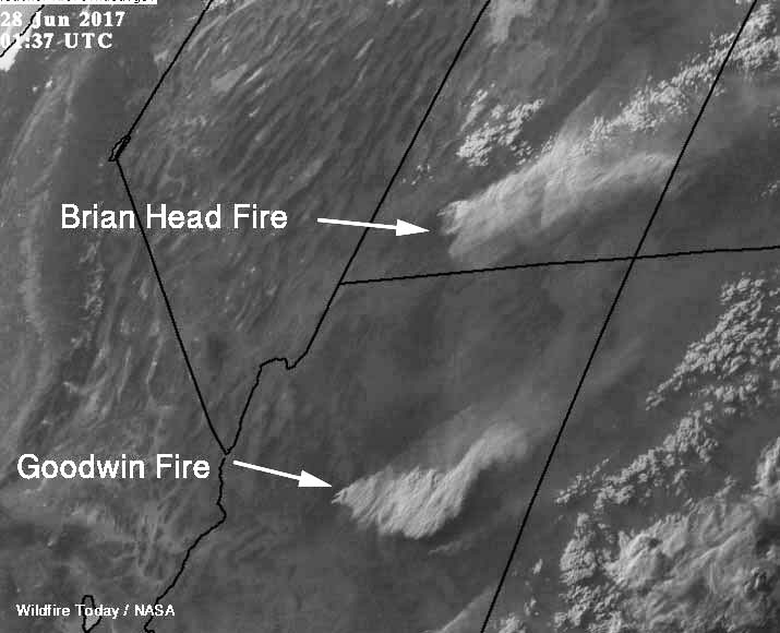
At 7:37 p.m. MDT a satellite photographed smoke from the Goodwin and Brian Head Fires.

On Tuesday afternoon the fire was driven by southwest to southeast winds of 8 to 15 mph with gusts up to 22 mph. A weather station at Spring Valley southeast of the fire Tuesday afternoon recorded 95 degrees and a relative humidity of 6 percent.

C-130 Drop Goodwin Fire
A C-130 drops on the Goodwin Fire Tuesday evening, June 27. Screen grab from Fox10 live video.

The fire started three days ago on June 24 and is being managed by John Pierson’s Type 1 Incident Management Team.

Diane Souder, a spokesperson for the fire, said Tuesday at 5:50 p.m. MDT resources working on the fire included 2 air tankers, 4 helicopters, 29 engines, and 525 personnel.

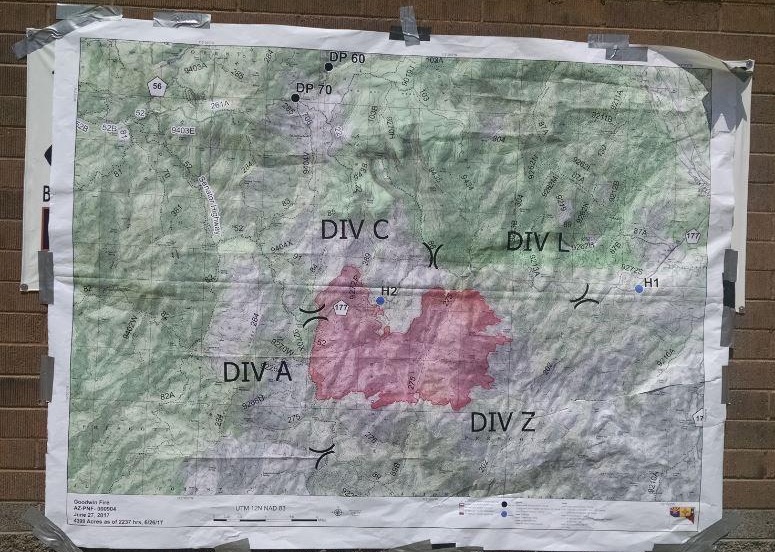
Map of the Goodwin Fire
Map of the Goodwin Fire posted by John Pierson’s Type 1 Incident Management Team June 27, 2017.

Thanks and a tip of the hat go out to Tom.
Typos or errors, report them HERE.

Red Flag Warnings, June 27, 2017

The National Weather Service has issued Red Flag Warnings for areas in California, Utah, Arizona, and Colorado.

The area where the Brian Head Fire is burning east of Cedar City, Utah could see 73 degrees, relative humidity of 9 percent, and southwest winds of 10 to 17 mph gusting up to 24.

The map was current as of 7:30 a.m. MDT on Tuesday. Red Flag Warnings can change throughout the day as the National Weather Service offices around the country update and revise their forecasts.

Brian Head Fire spreads another 4 miles to northeast

The fire has now burned almost 50,000 acres.

(UPDATED at 8:37 p.m. MDT June 27, 2017)
(Originally published at 8 a.m. MDT June 27, 2017)

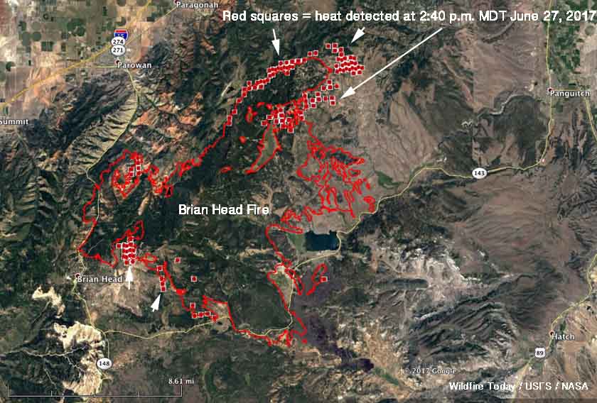
Map Brian Head Fire
Map of the Brian Head Fire. The red squares represent heat detected by a satellite at 2:40 p.m. MDT June 27, 2017. The red line was the perimeter at 12:11 a.m. MDT June 27, 2017. Click to enlarge.

****

Strong southwest winds gusting over 40 mph combined with relative humidity of five percent to push the Brian Head Fire in Utah another four miles to the northeast. Flames rising to 100 feet were reported by firefighters. The big run Monday afternoon added another 6,190 acres to bring the total burned area to 49,626. More fire activity south of Highway 143 resulted in another 200 acres burned east of the 050 Road.

The weather conditions on Tuesday will not be as severe as Monday, but could still result in significant additional spread of the fire while a Red Flag Warning in effect. The forecast for the fire area calls for 73 degrees, relative humidity of 9 percent, and southwest winds of 10 to 17 mph gusting up to 24.

smoke Goodwinda and Brian Head Fires
At 7:37 p.m. MDT a satellite photographed smoke from the Goodwin and Brian Head Fires.

With that forecast in mind, firefighters are looking several miles north of the fire to where the fuels change from old-growth timber to sage and grass, which should result in more successful suppression efforts.

Evacuations are still in effect for many areas and Highway 143 is closed from the cemetery in Parowan to milepost 50 outside of Panguitch. Mammoth Creek Road is closed at the junction with Highway 143. The north side gate of 143/148 is closed. The Dixie National Forest has expanded its area closure to include Forest lands north of Highway 14.

Brian Head Fire was very active Monday afternoon

smoke Brian Head Fire satellite
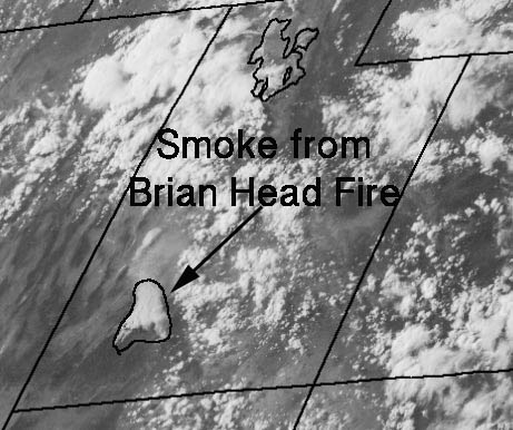
A satellite captured a photo of smoke created by the Brian Head Fire in Utah at 5:45 p.m. MDT June 26.

The Brian Head Fire east of Cedar City, Utah was influenced by strong winds from the southwest that at times gusted over 40 mph while the relative humidity dipped to five percent.

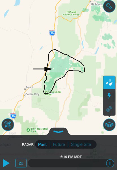
The intense burning caused a pyrocumulus cloud to develop as the fire and the smoke moved to the northeast. As you can see here, a satellite photographed the smoke plume and it was also detected by radar.

Only judging from the fire intensity shown in these images, I would be surprised if the indirect contingency firelines constructed Sunday by dozers northeast of the fire were able to constrain the blaze as hoped.

smoke radar Brian Head Fire
Radar detected smoke from the Brian Head Fire in Utah at 6:10 p.m. MDT June 26.

Forest Service Chief to report to new Acting Under Secretary

The new Secretary of Agriculture, Sonny Perdue, has selected a new Acting Under Secretary for National Resources and Environment, Dan Jiron. The U.S. Forest Service will be the only agency to report to Mr. Jiron.

He has a wealth of experience with the the U.S. Forest Service and other government organizations, including serving as the Information Officer for the South Canyon Fire Investigation Team in 1994.

In a message he recently distributed, Secretary Perdue described Mr. Jiron’s employment history:

“Dan Jiron will fill the role of Acting Deputy Under Secretary for Natural Resources and Environment.  With more than 29 years of public service and natural resources management, Jiron was appointed Associate Chief of the Forest Service in July 2016.

“Prior to this appointment, Jiron served in many leadership positions, including Regional  Forester of the Rocky Mountain Region; Deputy Regional Forester in the Pacific Southwest Region; Forest Supervisor of the Santa Fe National Forest; District Ranger on the Salt Lake Ranger District of the Uinta-Wasatch-Cache National Forest; District Ranger on the South Park Ranger District of the Pike and San Isabel National Forest, Comanche, and Cimarron National Grasslands; Director of Communications and Legislative Affairs of the Intermountain Region, National Press Officer in Washington, D.C.; and aide to United States Senator Ben Nighthorse Campbell of Colorado.

“Jiron earned a bachelor’s degree from Colorado State University and a Master’s degree from Regis University of Denver.”

Thanks and a tip of the hat go out to Dick.
Typos or errors, report them HERE.