60 minutes: “Wildfires on the Rise”

Above: One of the homes that survived the Eiler Fire in northern California, August, 2014. Photo by Bill Gabbert.

The CBS TV show 60 Minutes recently aired a story titled, “Wildfires on the rise due to drought and climate change“, concentrating on how to deal with the increasing number of wildfires, and particularly what homeowners can do to protect their investments.

Below is an excerpt from the transcript:

Events like [the Yarnell Hill Fire that killed 19 member of the Granite Mountain Hotshots] add urgency to the work at a U.S. Forest Service lab. In this building in Missoula, Montana, scientists study how fires spread.

And one of them, Jack Cohen, made a specialty of how to better defend homes.

Jack Cohen: Clearly we’re not gonna solve the problem by telling people they’re gonna have to move their houses into a city from being out in the woods.

Steve Inskeep: Not gonna happen.

Jack Cohen: Right? It’s not gonna happen for a whole bunch of reasons, one of which is that the population who live there, including me– aren’t gonna do it.

Steve Inskeep: Is it reasonable for a homeowner in that situation, a fire bearing down on their neighborhood to just say, “Look, I pay my taxes. There are firefighters, there’s a fire department. The forest service, if it’s public land, has thousands of firefighters. It’s their job; put it out?”

Jack Cohen: So what if they can’t? Then the question becomes one of, “Well, if the extreme wildfires are inevitable does that mean that wildland-urban fire disasters are inevitable?” And my answer to that is no.

Growth of the Pinal Fire south of Globe, Arizona slows

Posted on Categories UncategorizedTags ,

Above:  Most of the activity on the Pinal Fire Saturday was a firing operation on Divisions A and D as the Payson and Prescott Hotshots were conducting burning operations along the ridge tops. The photo looks south from the western part of Globe, Arizona towards the Pinal Mountains.

The Pinal fire five miles south of south of Globe Arizona slowed on Saturday, adding about 200 acres to bring the total to 6,610 acres. On Sunday the fire was active on the north side six miles south of the community of Miami.

Firefighters have been conducting burning operations along Forest Road (FR) 651 to help keep the fire within the planned perimeter and lessen the impacts of post-fire effects. If conditions allow, the controlled burning will likely last about three to five more days.

All of the photos were taken by Tom Story during the afternoon of May 27, 2017.

Pinal Fire Arizona Globe
Members of the Escudilla Fire Crew hike along a ridge above homes in Kellner Canyon. The Type 2 crew was clearing brush around the residences as part of structure protection efforts on the Pinal Fire.
Pinal Fire Arizona Globe
Homeowner Jarom Lewis clears brush on his property adjacent to the Tonto National Forest on Kellner Canyon Road. The area south of the Globe City Limits along Kellner and Ice House Canyons was under a pre-evacuation order near the Pinal Fire south of town.
Pinal Fire Arizona Globe
The Escudilla Fire Crew clears brush along the Tonto National Forest boundary above homes in Kellner Canyon as part of structure protection efforts in an area under a pre-evacuation alert near the Pinal Fire in the mountains south of Globe, AZ.

LA County Fire Museum purchases Granite Mountain Hotshots’ crew buggies

Above: One of the Granite Mountain Hotshots’ crew buggies was near the front of the procession that brought the 19 fallen firefighters from Phoenix to Prescott, July 7, 2013. Photo by Bill Gabbert.

Tuesday night the Prescott, Arizona City Council voted unanimously to accept the bid of the Los Angeles County Fire Museum to purchase the two crew carriers (or crew buggies) that were used by the Granite Mountain Hotshots.

Nineteen of the 20 Granite Mountain Hot Shot crewmembers perished at the Yarnell Hill Fire on June 30, 2013.

The trucks, which carried the Granite Mountain Hotshots throughout the Southwestern U.S. during the 2013 wildfire season, were deemed “surplus properties” by the City of Prescott after it disbanded the crew. The museum’s bid of $25,000 for both vehicles was the only bid submitted, according to Prescott City Manager Michael Lamar. Under terms of the deal, both of the buggies will be owned by the County of Los Angeles Fire Museum.

One of the buggies will go to the County of Los Angeles Fire Museum in Bellflower, California and the other one is slated to be placed on loan to the Hall of Flame fire museum in Phoenix, Arizona. When a suitable facility is built in Prescott, the truck at the Hall of Flame will be moved to Prescott.

California inmate firefighter killed by falling tree

Matthew Beck firefighter
Matthew Beck. Photo credit: CDCR.

(Revised at 1:13 p.m. MDT May 27, 2017)

The California inmate firefighter in Humboldt County was killed May 24 while working on a county roads project in the northwestern part of the state in Del Norte County.

According to the California Department of Corrections and Rehabilitation, Matthew Beck, 26, was working with a crew in the Hoopa area. He suffered major head, neck and back injuries when a 120-foot tall tree uprooted and fell on him. He died before life-flight crews were able to reach him.

“We are saddened by the death of Matthew Beck, and our thoughts and prayers are with his family and friends,” said CDCR Secretary Scott Kernan. “The inmates who year after year help protect our communities from the devastation of fires perform a valuable public service, and it is a tragic event when we lose one of them.”

Mr. Beck, who was assigned to the Alder Conservation Camp in Del Norte County, was serving a six-year sentence for burglary and was due to be parolled in October. He is the fourth inmate firefighter to die on a fire since the conservation program was created in the 1940s.

In February of 2016 another California inmate firefighter, Shawna Lynn Jones, 22, died after being struck by a boulder that rolled down a hill on the Mulholland Fire near Malibu.

Our sincere condolences go out to the friends, family, and coworkers of both firefighters.

This article has been edited to rectify incorrect information initially provided by the CDRC. The firefighter was not working on a fire at the time of the accident.

Caifornia Fuels and Fire Behavior Advisory

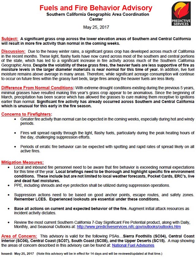
The Southern California Geographic Area Coordination Center has issued a Fuels and Fire Behavior Advisory for the central and southern areas of California due to a heavier than usual grass crop brought on by above average winter rains. Because of the vegetation and climate in Southern California it seems like we hear similar warnings often — heavy rains bring lots of flashy grass fuels, and a dry winter results in low fuel moistures. An average winter can mean typical fire potential, which in this area can still mean large devastating wildfires. But as we often say, the most important factor that affects the number of acres burned is the weather during the fire season.

Below is an excerpt from the Advisory. Following that is the entire document.

****

“Due to the heavy winter rains, a significant grass crop has developed across much of California in the recent months. These light, flashy fuels have now cured across most of the southern and central portions of the state, which has led to a significant increase in fire activity across much of the Southern California Geographic Area. Despite the volatility of these grass fires, the heavier fuels are less supportive of fire as moisture levels in the larger diameter materials is near normal for this time of year. In addition, live fuel moisture remains above average in many areas. Therefore, while significant acreage consumption will continue to occur on future fires within the grassy fuel beds, large fires among the heavier fuels are less likely.”

Fuels And Fire Behavior Advisory SoCal

Thanks and a tip of the hat go out to Ken.
Typos or errors, report them HERE.

Drones interfere with aviation operations on Pinal Fire

Above: Undated Inciweb photo of the Pinal Fire.

Four separate incidents involving hobbyists flying drones are hindering operations on the 4,991-acre Pinal Fire since the fire was detected May 8 in the Tonto National Forest five miles south of Globe, Arizona.

The latest drone sighting occurred May 24, 2017. An air tanker flying over the fire was forced to release its retardant at a higher altitude for safety reasons. The higher drop reduced the retardant’s effectiveness on the fire. Subsequently, aviation operations were suspended until the drone issue was resolved.

On May 20, 2017, a law enforcement officer cited a hobbyist for flying a drone near the Pinal Fire.

Pinal Fire map
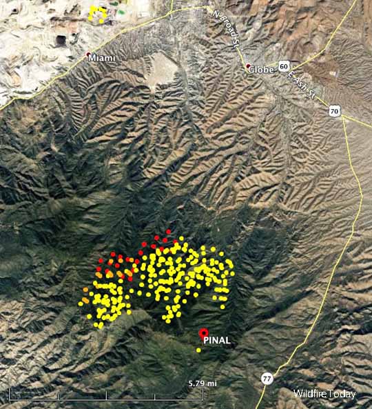
Map showing heat detected by a satellite over the Pinal Fire. The red dots are the most recent, from 3:15 a.m. MDT May 26, 2017.

Forest Service officials continue to emphasize that flying drones over or in close proximity to wildfires is illegal, endangers aviators as well as crews on the ground, and slows operations which potentially could result in the fire increasing in size.

Deputy Forest Supervisor Tom Torres, Tonto National Forest, explained that flying a drone near a wildfire is, in fact, breaking the law.

“The U.S. Code of Federal Regulations 43 CFR 9212.1(f) – indicates that it is illegal to resist or interfere with the efforts of firefighter(s) to extinguish a fire,” Torres said. “Doing so can result in a significant fine and/or a mandatory court appearance.

Drone operators determined to have endangered manned aircraft or people on the ground and/or interfered with wildfire suppression may be subject to civil penalties, including fines of up to $25,000, and potentially criminal prosecution.

Management of the fire

The Pinal Fire is being managed, not aggressively suppressed. One of the objectives is to create a continuous fuel break between the Pinal Mountains and the town of Globe five miles to the north.

Firefighters are involved in preparation and defense of structures and infrastructure along the indirect control lines from which firing operations could be conducted where necessary to maintain low intensity fire conditions and prevent unwanted impacts to the values at risk.

Thanks and a tip of the hat go out to Tom.
Typos or errors, report them HERE.