New USFS Fire Director selected

Shawna Lagarza Tom Harbour
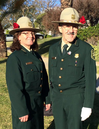
Shawna Legarza (left) the Director of Fire and Aviation for the U.S. Forest Service’s California Region, and Tom Harbour, the Director of Fire and Aviation for the Forest Service, at the Rose Parade, January 1, 2015.

Shawna Legarza has been selected as the national Director of Fire and Aviation for the US Forest Service. She will replace Tom Harbour who retired at the end of 2015. Currently Ms. Legarza is the regional Fire Director for the Forest Service’s California region. She will start in the position on July 4.

Ms. Legarza launched her federal career with the Bureau of Land Management in 1989 as an engine crew member in Elko, NV. A short time later, she joined the Forest Service and worked as a hotshot crew member in Carson City, NV, and a Hotshot Superintendent in Durango, CO. She subsequently took on a number of leadership positions in fire and aviation that include District Fire Management Officer on the San Juan National Forest, CO, and Forest Fire Management Officer on the San Bernardino National Forest in Southern California.

Ms. Legarza earned a Bachelor’s and a Master’s degree in Kinesiology at the University of Nevada Las Vegas, and Doctorate of Psychology at the University of the Rockies, Colorado Springs, CO.

She will be replaced in California Region 5 by Acting Fire & Aviation Director Patty Grantham, Forest Supervisor of the Klamath National Forest. Ms. Grantham works closely on the national line officer team for fire and has received awards for her fire leadership in building community partnerships and in restoring fire-adapted landscapes. She has worked on six national forests across the West and holds a bachelor’s degree in Forest Science from the University of Washington.

Red Flag Warnings, June 16, 2016

wildfire Red Flag Warning 6-16-2016

The National Weather service has posted Red Flag Warnings for areas in New Mexico and Colorado. The weather in Utah apparently did not meet the Red Flag criteria.

The maps were current as of 7:34 a.m. MDT on Thursday. Red Flag Warnings can change throughout the day as the National Weather Service offices around the country update and revise their forecasts and maps. For the most current data visit this NWS site.

Dog Head Fire continues to spread to the east near Chilili, New Mexico

(UPDATE at 1:47 p.m. MDT June 19, 2016)

Tanker 160 drops on Dog Head Fire
Air tanker 160, an RJ85, drops on the Dog Head Fire in New Mexico. Undated InciWeb photo.

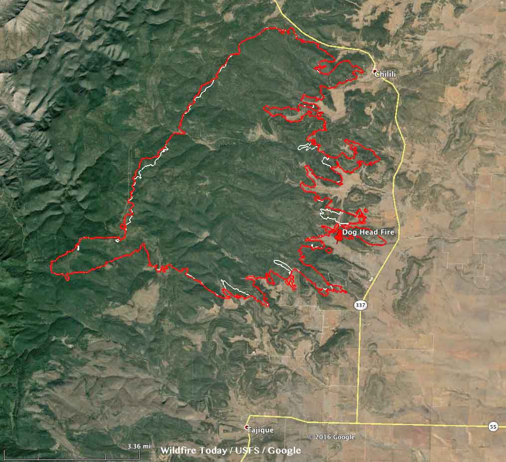
The Dog Head fire, 3 miles north of Tajique, New Mexico, continued to spread to the east over the last two days, adding approximately 1,500 acres, to bring the size up to 17,617 acres. The fire is working its way through fingers of timber on ridges that are separated by grassy areas in the flatter ground in between the ridges.

Weather forecast Dog Head Fire
Weather forecast for the Dog Head Fire area. NWS. Click to enlarge.

Higher humidity moderated fire behavior on Saturday but the forecast for Sunday includes 13 percent RH, temperature about 90 degrees, and wind out of the southeast at 9 mph. Weather forecasters expect 14 mph southwest winds on Monday with slightly higher humidity.

Map Dog Head Fire
Map of the Dog Head Fire at 4 a.m. MDT June 19, 2016 (the red line). The white line is from 3:30 a.m. MDT June 17, 2016. Click to enlarge.

****

(UPDATE at 8:35 p.m. MDT June 17, 2016)

The Dog Head Fire 17 miles southeast of Albuquerque was less active on Friday than on previous days. This was due in part to lighter winds and the fact that in some areas on the east side the fire has spread beyond the timber into much lighter fuels where it can be attacked more successfully by firefighters and aircraft.

A satellite overflight at 1:30 p.m. on Friday detected very few heat sources. But stronger winds in the late afternoon may have changed that situation.

****

(UPDATED at 6:42 a.m. MDT June 17, 2016)

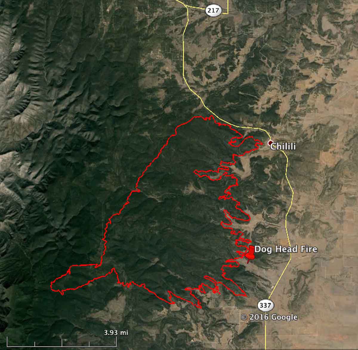
Map Dog Head fire
Map of the perimeter of the Dog Head fire at 3:30 a.m. MDT June 17, 2016.

The incident management team reports that 24 single residences and 21 other minor structures have been destroyed in the Dog Head Fire near Chilili, New Mexico.

On Thursday the fire continued to push towards the east and northeast toward Chilili Land Grant. Approximately 16,000 acres have burned, according to the IMT.

Hot, dry and unstable weather is in the forecast from Friday into the weekend.

Continue reading “Dog Head Fire continues to spread to the east near Chilili, New Mexico”

Cedar Fire near Show Low, Arizona

(UPDATED at 10 a.m. MDT June 24, 2016)

cedar fire helicopter
Helicopter refilling water bucket on Cedar Fire. Undated & uncredited photo from InciWeb.

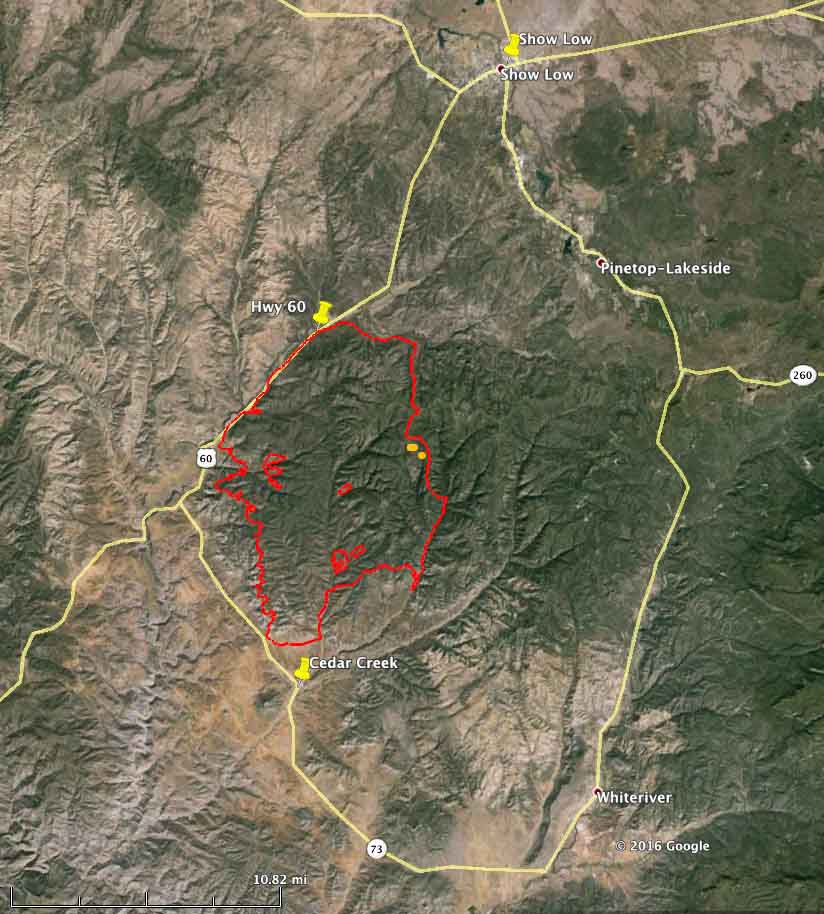
The Cedar Fire south of Show Low, Arizona continues to spread across the Arizona landscape. The Incident Management Team reports that it has burned 45,918 acres, an increase of about 5,000 acres over the last two days. Firefighters still have miles of open fire perimeter and have been working on constructing firelines and conducting burnouts on the east and west flanks.

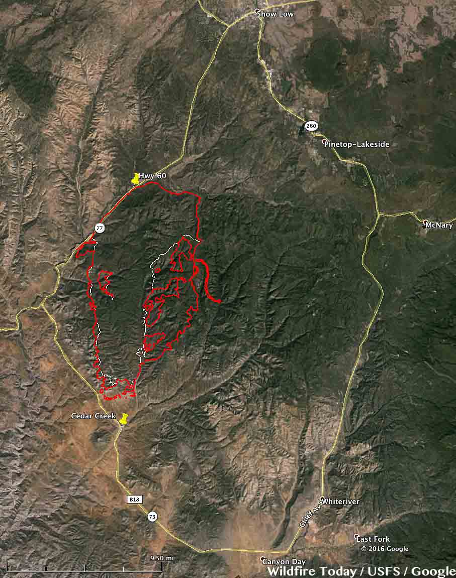
Map Cedar Fire
Map of the Cedar Fire perimeter at 9 p.m. MDT June 23, 2016.

SR-60 between Carrizo and Show Low remains closed due to smoke conditions as firefighters actively work near the highway. SR-73 through Whiteriver remains open from Carrizo to Hon-Dah.

****

(UPDATED at 9:42 a.m. MDT June 22, 2016)

3-D Map Cedar Fire
3-D Map of the Cedar Fire at 10 p.m. MDT June 21, 2016. Looking north.Click to enlarge.

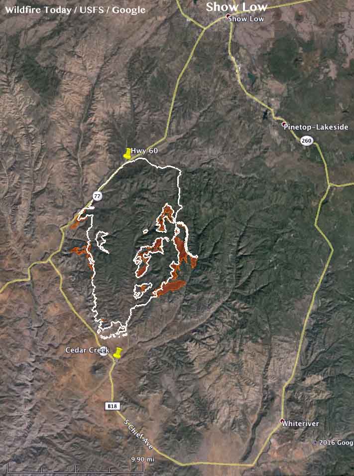
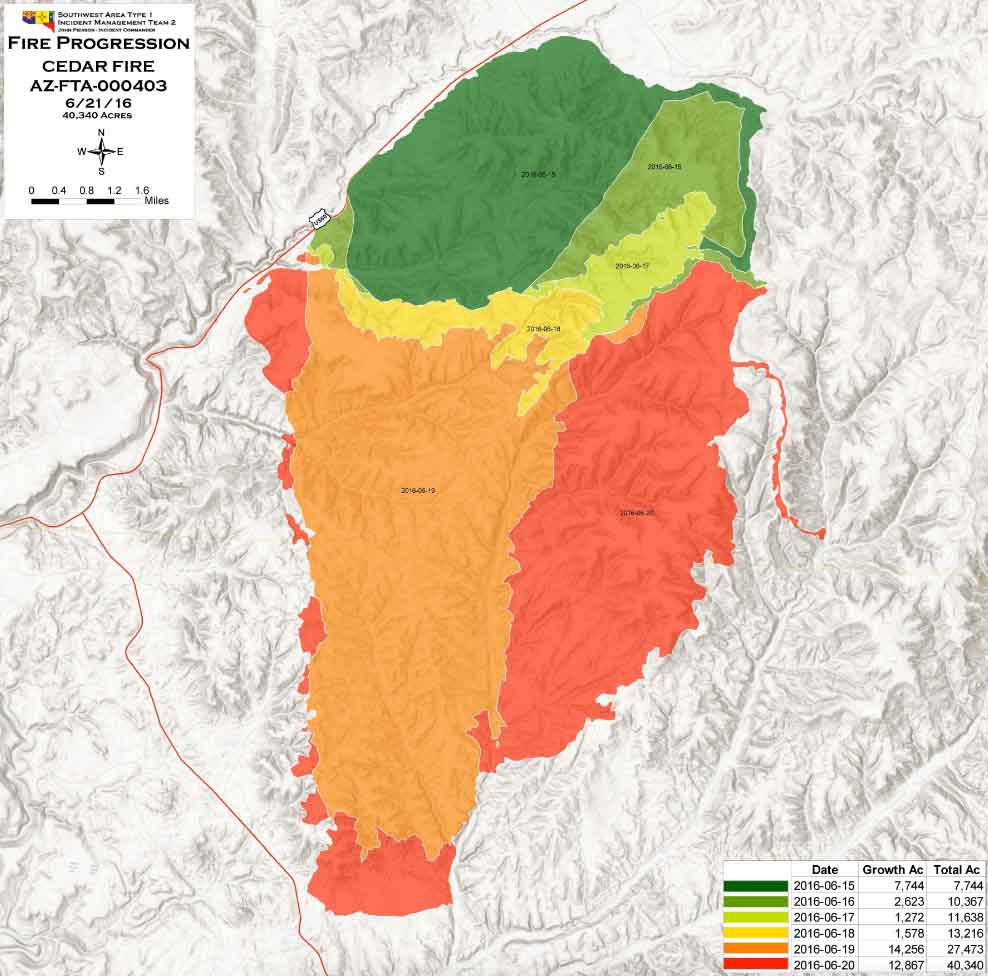
The Cedar Fire south of Show Low Arizona added another 5,000 acres on Tuesday to bring the number acres burned up to 40,340, according to the Southwest Geographic Area Coordination Center. Most of the growth was on the east side, and on the west side near Highway 60.

The southern perimeter is still approximately 1 1⁄2 miles north of Highway 73, and approximately 2 miles north of the Cedar Creek community. The north side of the fire remains fairly quiet.

Map Cedar Fire
The brown shaded areas show the additional growth of the Cedar Fire as of 10 p.m. MDT June 21, 2016. The white line is the perimeter from 24 hours before. Click to enlarge.
Progression map Cedar Fire
Progression map of the Cedar Fire, June 21, 2016. Click to enlarge.

****

(UPDATED at 8:20 a.m. MDT, June 21, 2016)

map Cedar Fire
The red line was the perimeter of the Cedar Fire at 4:13 a.m. MDT June 21, 2016. The white line was the perimeter from about 24 hours before. Click to enlarge.

The Cedar Fire south of Show Low, Arizona continued to grow substantially on Monday adding another 9,000 acres to bring the total burned area up to about 35,000 acres. The fire was active on the southwest and south sides, but was extremely active on the east side where it spread over two miles further east.

The Incident Management Team (IMT) has posted a video briefing on the fire that was recorded on Monday.

Continue reading “Cedar Fire near Show Low, Arizona”

Satellite photo shows three large columns of smoke in Arizona & New Mexico

Above: map showing three large columns of smoke in Arizona and New Mexico, at 5:15 p.m. MDT, June 15, 2016.

The satellite photo above shows three large columns of smoke in Arizona and New Mexico. We have tentatively identified them, but this is not yet confirmed, as the North Fire (25 miles southwest of Magdalena, NM), the Dog Head Fire (about 25 miles southeast of Albuquerque, NM), and the Cedar Creek Fire, a new fire 12 to 16 miles southwest of Show Low, Arizona.

The North Fire is a limited suppression fire, while the other two are being fully suppressed.

The Cedar Creek Fire started around noon on Wednesday and by 3 p.m. had burned about 1,000 acres. Strong winds were pushing it toward Show Low. Fire officials have identified a trigger point. If the fire reaches the B65 Road they will order evacuations of Show Low and Forestdale.

Earlier today we posted information about six fires in these two states, including the North and Dog Head fires.

Strong winds were predicted for parts of Arizona and New Mexico today, along with a Red Flag Warning for the area southeast of Albuquerque, NM.

wind forecast arizona
The wind gust forecast for 3 p.m. MDT June 16, 2016.

Thanks and a tip of the hat go out to Tom.

Wildfire activity in Arizona and New Mexico

Above: Dog Fire, June 14, 2016. Photo by Incident Management Team.

Cool, wet weather has slowed wildfire activity in Northern California, Washington, and Oregon. The 2,396-acre Pony fire on the Klamath National Forest, about 15 miles southwest of Happy Camp, received rain on Tuesday.

It is a different story in Arizona and New Mexico where more than half a dozen fires have burned significant acreage. All of them are limited suppression fires except for the Dog Head Fire that started Tuesday morning.

Jack Fire

This limited suppression fire has burned 36,408 acres in central Arizona 24 miles southeast of Sedona. This is an increase of about 11,000 acres over the last three days. There is a red flag warning in effect from 11 a.m. Wednesday morning to 7 p.m. in th evening due to strong winds and low relative humidity for the area. Higher temperatures and low relative humidity are expected over the next couple days.

Dog Head Fire

Rich Nieto’s Type 2 Incident Management Team will assume command of this 682-acre fire Wednesday evening. It started at 11 a.m. on Tuesday and as of Wednesday morning voluntary evacuations are occurring for Monzano Morning, Aceves Road, and La Parra Road.

Today they expect temperatures in the 80s and low 90s, southwest wind of 10 to 25 with gust to 35, and relative humidity around 10 percent.

It is about 25 miles southeast of Albuquerque, New Mexico on the Cibola National Forest and National Grassland. This is the only one of these six fires that is not a limited suppression fire.

McKenna Fire

This limited suppression fire northwest of Silver City, New Mexico has burned 10,210 acres since it was reported on May 6.

North Fire

This limited suppression fire has burned about 22,000 acres 25 miles southwest of Magdalena, New Mexico since it was reported on May 21.

North Fire
North Fire. Undated photo by Ken Watkins.

Spur and Turkey Fires

The Gila National Forest in southwest New Mexico is releasing very little information about these two limited suppression fires that at last report had each burned between 2,000 and 3,000 acres.