Report released on entrapment of six firefighters on the Cedar Fire in Arizona

Above: Fire whirl on the Cedar Fire, June 28, 2016, around the time of the entrapment. Screen grab from the video.

A report has been released on the entrapment of six firefighters that occurred on the Cedar Fire south of Show Low, Arizona June 28, 2016.

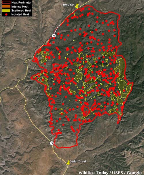
The firefighters were part of the Navajo Interagency Hotshot Crew (NIHC) that remained along with two Type 6 engines and possibly one other crew after the Type 1 Incident Management Team was released the previous day. The assignment of half the crew, nine firefighters, was to “monitor” a part of the southwest side of the fire that had six miles of uncontained fire edge. The other half was working on the southeast side.

Three of the nine personnel on the southwest side served as lookouts while the remaining six were monitoring and checking the fire edge. When a very large fire whirl developed near the six, they realized their escape route was cut off, and took refuge in a previously burned area. The ground fuels had burned, but the canopy was still intact. As the fire approached they deployed their fire shelters, remaining in them for about 30 minutes.

cedar fire entrapment site
The entrapment site at the Cedar Fire.

After the fire whirl subsided, the squad members were able to hike out to staged vehicles. They were transported in three ambulances, medically evaluated, and transported to Summit Hospital in Show Low, Arizona where they were evaluated. Two firefighters were treated for smoke inhalation and all were released by 10 p.m. that evening.

The report says the personnel deployed and entered the shelters just as they had practiced several times in training, and the devices worked as designed. There were no difficulties, as reported at other entrapments, with the PVC bags becoming soft and difficult to open.

Thankfully there were no serious injuries and the training the firefighters had received paid off.

But there are a number of interesting facts about what occurred before the entrapment

Resources on the fire

On June 27, the day before the entrapment, the Type 1 Incident Management Team issued their final update on the 45,977-acre fire just before they were released later that day. Below is a portion of the document.

cedar fire update

The report claims the Type 1 Team recommended that the number of personnel assigned be reduced on Tuesday June 28 to about 400. But on Monday, June 27 all firefighters except for two Type 6 engines were released. With a 70 percent chance of rain in the weather forecast, on Tuesday the local agency decided to replace the Type 1 Team with a Type 4 Incident Commander, two Type 6 engines, and one or two hand crews. The crew(s) had to be re-mobilized on Tuesday after being released. Some aircraft were also assigned on Tuesday.

Video of the large fire whirl

Weather on Tuesday, the day of entrapment

About 20 minutes before the 2:45 p.m. entrapment the weather at the fire was 95 degrees, 21 percent relative humidity, with a 7 to 10 mph wind out of the south. Although “numerous” people observed dust devils and fire whirls before the large fire whirl formed, there was no discussion about modifying fire suppression tactics. Dust devils can be an indicator of the potential for extreme fire behavior.

cedar fire entrapment
Fire whirl on the Cedar Fire, June 28, 2016. Screen grab from the video.

Pioneer Fire in Idaho is one of 5 fires in US with over 1,000 firefighters assigned

The Pioneer Fire was very active Monday and Tuesday.

Above: Pioneer Fire. Uncredited/undated InciWeb photo.

On Tuesday the Pioneer Fire in central Idaho continued its march to the north, adding another 16,000 acres to bring the total to over 157,000 acres. Burning 32 miles northeast of Boise and 23 miles west of Stanley, it has been creating huge convection columns rising 30,000 feet into the atmosphere for the last two days.

Map Pioneer Fire
Map of the Pioneer Fire at 8 p.m. MDT August 30, 2016.

Most of the growth on Tuesday was on the north side while it was pushed by an 8 to 12 mph wind gusting at 18 to 24 that was variable, but mostly out of the south. As we write this at 2:50 p.m. on Wednesday, the wind so far today has been out of the west and northwest at 4 to 10 mph with gusts of 16 to 24. The smoke being pushed to the east will probably make the air quality rather unpleasant in Stanley, due east of the fire.

The fire was very active late into Tuesday night due to the low relative humidity which ranged from 24 to 30 percent during the night at the White Hawk weather station at 8,344 feet elevation. At 2:33 p.m on Wednesday it was 66 degrees with 21 percent humidity.

Map Pioneer Fire
Map of the Pioneer Fire August 30, 2016. The black line is completed fireline. The red is uncontrolled fire edge.

The Pioneer Fire is one of five currently active fires in the United States that are staffed by more than 1,000 personnel.

[ultimatetables 1 /]

As of Tuesday evening the total number of resources assigned to fires in the US included 444 hand crews, 1,060 engines, 147 helicopters, and 19,064 personnel. When the number of crews approaches 500 and there are almost 20,000 personnel committed, you know things are getting busy.

A few more details released about fire shelter deployment on the Cedar Fire

On Sunday the Bureau of Indian Affairs released a “72-hour report” that contains a few more details about the entrapment of six firefighters and deployment of their fire shelters on the Cedar Fire south of Show Low, Arizona.

The new information includes mentions of a large fire whirl and three lookouts that were posted.

Below is the press release version of the 72-hour report. The formal memo-style document is HERE. They contain approximately the same information.

****

“On June 28, a large fire whirl formed near six members of the Navajo Interagency Hotshot Crew (IHC), entrapping them. In response to the intense heat, flying ash and woody debris, the firefighters deployed their fire shelters.

Throughout the 15 minute event, the crew maintained radio communication with each other and agency personnel. Aviation and safety resources were immediately dispatched to assist the crew.

After the fire whirl passed, the IHC walked out of the fire area and were transported to Summit Healthcare in Show Low, Arizona. Two firefighters were treated for smoke inhalation and all six firefighters were released from the hospital that evening. After the crew was released, a Critical Incident Stress Management Team was made available to the crew.

The Bureau of Indian Affairs initiated an Interageny Serious Accident Investigation (SAI) that evening. On June 30, the SAI Team members, led by Clark Richins, Team Leader, Bureau of Indian Affairs, reported to Western Region, Fort Apache Agency. Members of the SAI Team include: Chief Investigator, Safety Officer, Personal Protective Equipment Specialist, Long Term Fire Analyst, Hotshot Crew Representative, Public Information Officer, Writer/ Editor, and Regional and National Agency Liaisons.

The investigation will collect evidence, which includes conducting personnel interviews, inspecting equipment and analyzing photographs, weather and voice data. On June 30, the SAI Team completed their interviews of the IHC, which allowed the crew to return home.

According to the National Wildfire Coordinating Group Terminology Glossary, a fire whirl is a spinning vortex column of ascending hot air and gases rising from a fire and carrying aloft smoke, debris, and flame. Fire whirls may range in size from less than one foot to over 500 feet in diameter and have the intensity of a small tornado.

Prior to the event, the crew was working along the western flank of the uncontained fireline where they had previously been assigned for several days. At 12:00p.m three nearby lookouts observed low intensity surface fire, but by 2:00p.m., as the day got warmer, the fire behavior increased. These lookouts and an additional firefighter scouting the fireline witnessed the large fire whirl.

While managing wildland fires is inherently dangerous, all firefighters are trained to minimize the risk they take on every assignment. In the rare circumstance firefighters are faced with an impending entrapment, they are trained to consider all options to insure the safety of all crew members. This includes deploying fire shelters for protection from smoke, heat, and embers. The Navajo Interageny Hotshot Crew executed their training, which resulted in a successful outcome to a hazardous wildfire anomaly.

As a highly reliable organization, the wildland fire community strives to learn and transfer lessons learned on a continual basis. In the spirit of this culture, the BIA Western Region will provide the Factual Report to the Lessons Learned Center when the Report is finalized.”

****

Thanks and a tip of the hat goes out to Jonah.

Update on the condition of the firefighters who deployed fire shelters on the Cedar Fire

(UPDATED at 12:52 p.m. MDT June 30, 2016)

Today the BIA released a “24 Hour Report” about the fire shelter deployment on the Cedar Fire. It provided a few facts that were not previously disclosed by the agency.

The six firefighters deployed their shelters in an area that had already burned, and they were evaluated in the hospital for “smoke inhalation”.

The Serious Accident Investigation Team will be led by Jon Rollins, Chief Investigator for the National Park Service.

****

(Originally published at 9:52 p.m. MDT, June 29, 2016)

The Bureau of Indian Affairs provided more information today about the six firefighters on the Cedar Fire south of Show Low, Arizona who on June 28 found themselves in a situation where they had to deploy fire shelters. The firefighters, all from the Navajo Interagency Hotshot Crew, walked away from the site and were transported to Summit Healthcare in Show Low where they were treated and released that evening.

A Serious Accident Investigation Team has been formed and will investigate the circumstances surrounding the deployment.

We don’t know why or how the incident occurred, but if recent history holds true, we may never know, thanks to the unintended consequences of Senator Maria Cantwell’s and Representative Doc Hastings’ hastily conceived Public Law 107-203 signed into law in 2002.

But putting aside the unknown details of fire behavior, decisions made on the fireline, and the strategy and tactics being used on the Cedar Fire yesterday, there a few things that we do know.

  • The Type 1 Incident Management Team issued an update titled “Final Cedar Fire Update” on Monday, June 27. It said in part, “While 554 firefighters are working on the fire [Monday] morning, only the Team itself will remain by Tuesday afternoon. The Bureau of Indian Affairs (BIA) will assume command of the fire at 6 A.M. Tuesday.” That Monday update said the fire received rainfall on Sunday and more rain was expected on Monday.
  • The Type 1 Team turned the fire over to the Fort Apache Agency at 6 a.m. on Tuesday, June 28. There was no mention of a Type 2 or Type 3 Incident Management Team.
  • The Fort Apache Agency posted a fire update on Facebook at 1:05 p.m. on Tuesday, June 28 saying the resources on the fire that day were, “Navajo Hotshots, 3 Type 6 Engines, Fort Apache Fuels Type 2 IA Crew.” And, “Fire Personnel will continue to hold and mop up the fire.” These two crews and three engines probably amounted to a maximum of 50 people, plus miscellaneous overhead. This was down from 554 the previous day, a 91 percent reduction in personnel overnight.
  • Candy Lupe, a Public Information Officer with the Bureau of Indian Affairs’ Fort Apache Agency, told Wildfire Today that she was not sure exactly when the incident occurred but estimated it happened around 3 p.m. Arizona time on Tuesday, June 28.
  • The infrared scan of the fire conducted very early Monday morning, June 27, showed “scattered” and “isolated” heat over much of the fire. There was no record of an infrared scan prior to the day shift on Tuesday June 28, but they had been completed every day from June 17 through June 27.

We’re not pointing fingers or attempting to lay blame on anyone. Hopefully the investigation will bring to light some lessons that can be learned.

Carl WilsonThe incident brings to mind the Common Denominators of Fatal and Near-Fatal Fires, developed by Carl Wilson in 1976. Mr. Wilson put two lists together, a four-item list based on his studies of 61 fatal fires, and a five-item list that included an additional 31 near-fatal fires. More information about these lists is in our February 1, 2016 article, Are there 4 or 5 common denominators of fire behavior on fatal fires? Almost all recent wildland fire publications, if they publish the list, only have the four-item list.

These lists are not intended as a quick and easy checklist for investigators, nor are they rules or guidelines that must be followed. They are simply interesting commonalities seen on many fatal and near-fatal fires. Things to think about, not rules that must be adhered to.

Here is the five-item list that includes data from fatal and near-fatal fires:

  1. Most of the incidents occurred on relatively small fires or isolated sectors of larger fires.
  2. Most of the fires were innocent in appearance prior to the “flare-ups” or “blow-ups”. In some cases, the fatalities occurred in the mop-up stage.
  3. Flare-ups occurred in deceptively light fuels.
  4. Fires ran uphill in chimneys, gullies, or on steep slopes.
  5. Suppression tools, such as helicopters or air tankers, can adversely modify fire behavior. (Helicopter and air tanker vortices have been known to cause flare-ups.)”

Fire shelters deployed on the Cedar Fire — firefighters injured

(Originally published at 8:58 MDT June 28, 2016)

Today six firefighters deployed fire shelters on the Cedar Fire south of Show Low, Arizona.

Candy Lupe, a Public Information Officer with the Bureau of Indian Affairs’ Fort Apache Agency, said all six were transported to area hospitals with non-life-threatening injuries. Other than that she was not able to answer questions about the nature or extent of the injuries. After the fire in the area cooled, the firefighters were able to walk away from the accident site. Medical, air, and ground resources were deployed to the area to provide assistance. The six firefighters were described as “a portion of the crew” that was working near a flare up on the remaining uncontrolled fire line of the Cedar Fire. 

Ms. Lupe was not sure exactly when the incident occurred but estimated it happened around 3 p.m. Arizona time today, June 28.

Tuesday morning at 6 a.m. the Type 1 Incident Management Team demobilized and transitioned command to the Fort Apache Agency.

The “Final Cedar Fire Update” from Southwest Incident Management Team #2 was posted on InciWeb on June 27. At that time the fire was listed as being 45,977 acres, 75 percent contained, with 546 personnel assigned. The fire received rainfall on Sunday and more rain was expected on Monday. The report stated:

While 554 firefighters are working on the fire [Monday] morning, only the Team itself will remain by Tuesday afternoon. The Bureau of Indian Affairs (BIA) will assume command of the fire at 6 A.M. Tuesday.

An update on the fire that was posted on the Fort Apache Agency’s Facebook page around noon on Tuesday said:

The Southwest portion of the fire will continue to produce smoke as well as the interior of the fire.

Much of the rest of the update was devoted to fire rehabilitation activites.

Map Cedar Fire
This map shows the locations of heat detected on the Cedar Fire by a fixed wing aircraft at 2:43 a.m. June 27, 2016.

At 3 p.m. on June 28 the RAWS weather station “IRAWS 5 (Hwy 60 flat)(MST)” on the west side of the Cedar Fire recorded 90 degrees, 19 percent RH, and winds at 3 to 5 mph. Between 9 a.m. and and 5 p.m. the wind direction was very inconsistent, from the south, southwest, and northwest with variable gusts from 9 to 15 mph.

Our earlier primary article about the suppression of the Cedar Fire.

Thanks and a tip of the hat go out to Tom.

A virtual aerial tour of the site of the Cedar Fire in Arizona

This is virtual flyover of the site of the Cedar Fire 10 miles south of Show Low, Arizona, showing the fire perimeter as of 10 p.m. MDT June 17. There is also a quick stop at the Show Low Airport with photos of the helicopters that assisted firefighters on the ground by dropping water.