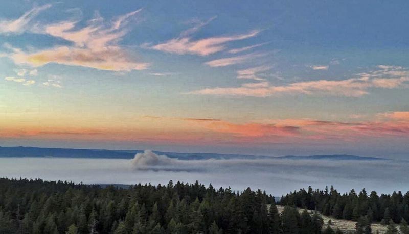
And the next day, July 4, we see the Operations Section Chief on the Corner Creek fire briefing firefighters:

More information about the Corner Creek Fire, 9 air miles south of Dayville, Oregon.
News and opinion about wildland fire

And the next day, July 4, we see the Operations Section Chief on the Corner Creek fire briefing firefighters:

More information about the Corner Creek Fire, 9 air miles south of Dayville, Oregon.
Areas of Washington, Oregon, Montana, California, and Montana are under Red Flag Warnings or Fire Weather Watches today for gusty winds, and low humidities.
In addition, northern California and southern Oregon are targeted for abundant lightning from Saturday evening through Sunday evening.
Firefighters in the Glacier Park area of northwestern Montana should expect a dramatic westerly to easterly wind shift by late Saturday afternoon, and by Saturday evening across much of west-central Montana.
The map was current as of 7:45 a.m. MDT on Saturday. Red Flag Warnings can change throughout the day as the National Weather Service offices around the country update and revise their forecasts and maps. For the most current data visit this NWS site or this NWS site.
The Commissioner of Public Lands in Washington State is very disappointed that the legislature approved only one-third of the increase he requested to beef up the number of fire engines and helicopter crews in the Department of Natural Resources for initial attack on new fires.
Below is an excerpt from an article in the News Tribune:
State lawmakers didn’t hesitate to pay $70 million to cover the costs of fighting last year’s wildfires after the flames died down.
But now, as wildfires again rage across the state, the head of the state’s chief wildland firefighting agency says he’s frustrated the Legislature wouldn’t pay a fraction of that amount to help stop new fires from getting out of control.
Commissioner of Public Lands Peter Goldmark said he got less than one-third of what he requested for early fire response in the state’s new two-year budget, which Gov. Jay Inslee signed into law late Tuesday.
“The Legislature has left me in a precarious position, with what I view as insufficient resources to meet the threat,” said Goldmark, who leads the state Department of Natural Resources. “Even in the face of (the current fires) and the threat to public safety that those fires contained, the Legislature didn’t seem to care about the public’s safety at all.”
[…]
On Friday, the Northwest Interagency Coordination Center reported more than a half-dozen large fires active throughout the state.
Fires scorched more than 400,000 acres in 2014, the most destructive fire season in state history.
Following that record-setting fire season, Goldmark requested more funding from the Legislature to staff additional fire engines and helicopter crews — about $4.5 million above what the agency received in its previous two-year budget for fire response. Yet in the state’s new $38.2 billion spending plan, Goldmark got only $1.2 million of the extra funding he requested.

You don’t usually think of smoke benefiting firefighters, especially their health, but the pollutants over a very widespread area are modifying the weather, making it a little easier to corral the numerous wildfires in some areas.
Below is an excerpt from The Weather Network.
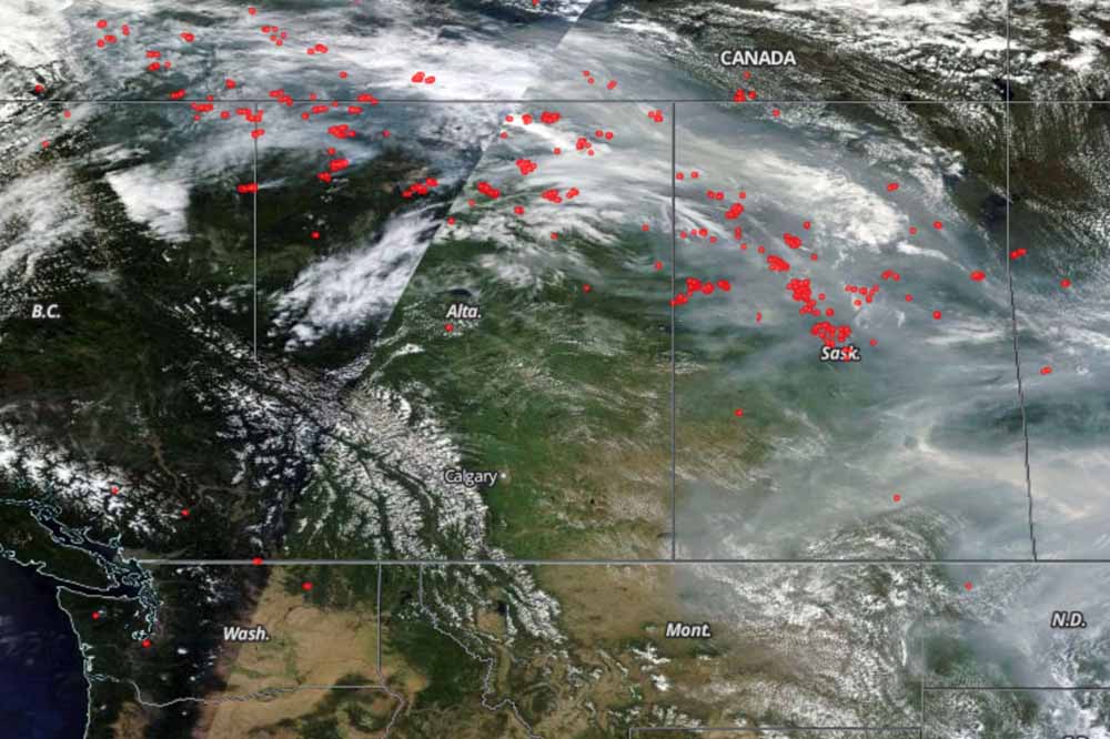
Thursday, July 2, 2015, 5:14 PM – Even as plumes of heavy smoke from Alberta and Saskatchewan wildfires force thousands from their homes, officials find a silver lining, as the smoke is actually keeping the fires more under control.
Evacuation centres in central and southern Saskatchewan are reportedly housing at least 5,000 people as of Thursday, all displaced from their homes by thick smoke drifting down from wildfires burning in northern parts of the province. The evacuations were prompted by the significant health risk this smoke represents, and Environment Canada has issued special air quality statements for northeastern Alberta, all of Saskatchewan and all but the northeastern regions of Manitoba in response.
Despite this health risk, though, the thick smoke is actually having a beneficial impact on the very fires that are producing it in the first place.
“As much as it’s not good for people, because the cloud layer filled with smoke and is so thick, our temperatures are roughly 10 degrees cooler and our humidity is 10 to 15 per cent higher,” said Steve Roberts, Executive Director of Saskatchewan’s Wildfire Management Branch, according to the Canadian Press. “That combination means the fire activity drops significantly.”
“It’s helped us secure, especially, those fires that are close to communities by putting people on the ground and getting some hose lines in place.”
But, the smoke is a double-edged sword. Sometimes the reduced visibility grounds firefighting aircraft:
Smoke hampering wildfire fighting in Saskatchewan #skfire #skwildfires http://t.co/FqPmQEBO1R pic.twitter.com/AJAZ48exE5
— 650 CKOM (@CKOMNews) July 3, 2015
The video below of a wildfire in Saskatchewan is stunning. It appears that the photographer was quite close to a very, very active fire.
If your device can’t handle the video above, try it at this site.
To see the most current smoke reports on Wildfire Today, visit the articles tagged “smoke” at https://wildfiretoday.com/tag/smoke/

Smoke from wildfires in Canada has been migrating into large sections of the United States for several days, and that trend continues today. Even in, for example, southwest South Dakota my view of the Seven Sisters is degraded by particulates from those fires. A couple of days ago quite a number of people searching on the Internet for “fire Rapid City” or “fire Black Hills”, ended up on Wildfire Today, thinking there was a wildfire nearby.
To be fair to Canada, some of the smoke in the U.S., but a comparatively small amount, is coming from fires in Washington and Oregon.

To see the most current smoke reports on Wildfire Today, visit the articles tagged “smoke” at https://wildfiretoday.com/tag/smoke/
Red Flag Warnings and Fire Weather Watches are in the forecasts for some areas in Washington, Oregon, and Idaho on Friday and Saturday for gusty winds and low relative humidities.
—Washington: Red Flag Warning from 3 p.m. Friday until 8 p.m. Saturday.
—Oregon: Red Flag Warning from noon Saturday until 8 p.m. Saturday.
—Idaho: Fire Weather Watch from Saturday morning through Saturday evening.
The map was current as of 8:30 a.m. MDT on Friday. Red Flag Warnings can change throughout the day as the National Weather Service offices around the country update and revise their forecasts and maps. For the most current data visit this NWS site or this NWS site.