PG&E plan to bury lines is shot down

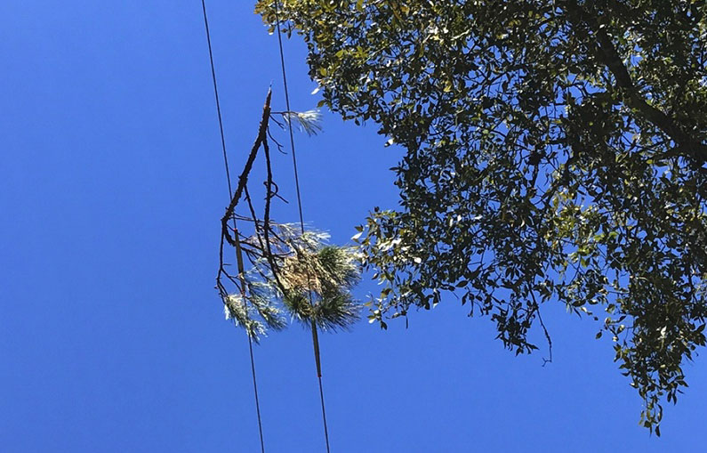
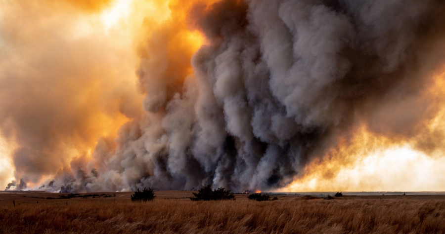
Pacific Gas & Electric — one of the nation’s largest utilities whose equipment has ignited some of California’s deadliest wildfires — wants to bury powerlines in some of its most at-risk areas to prevent fires like the 2018 Camp Fire, started by PG&E lines, that killed 85 people and burned the town of Paradise to the ground. Estimated total cost of the Camp Fire was about $422 billion.

11/08/2018 Camp Fire, NASA satellite image.

But state regulators are balking at the utility’s plan, the Associated Press reported, because it would take too long and cost an estimated $5.9 billion. The company’s customers, who already pay some of the highest rates in the country, would have to foot the bill.


UPDATE 10/18/2023:   According to a KEZI-TV report, Pacific Power recently announced it will receive $150 million in federal grant funding to improve its infrastructure for grid resilience and wildfire mitigation. The funding is from the U.S. Department of Energy, with just under $100 million earmarked for PacifiCorp’s grid resiliency project to reduce the effects of extreme weather on the grid serving disadvantaged communities at highest wildfire risk. An additional $50 million is earmarked for PacifiCorp’s Resiliency Enhancement for Fire Mitigation and Operational Risk Management project.


Regulators want PG&E to put protective covers over many of its overhead powerlines instead of burying them. The cover approach is cheaper, but riskier. PG&E says that burying a powerline reduces the chance it will start a fire by 99 percent because it can’t be blown down by windstorms. The protective cover would reduce that chance by just 62 percent.

tree limb on lines
Vegetation can cause faults and fires electrically. Distribution Fault Anticipation can detect this type of vegetation fault before the dangerous situation escalates. (Texas A&M Engineering)

MyMotherLode.com reported that the company is hoping to bury 2,100 miles of powerlines by 2026. But the California Public Utilities Commission (PUC), whose members are appointed by the governor, has not signed off on the plan, out of concerns about the estimated cost.

The Manteca Bulletin reported that customers would be expected to pay PG&E at least $40 more per month; the burying plan was put forth after the utility’s lowest rates were increased 170 percent or more since 2006.

PG&E originally wanted a 26 percent increase, and is now asking for an 18 percent increase. The PUC said they’d consider a maximum of 13 percent.

PG&E filed for bankruptcy protection in 2019 after it faced more than $30 billion in damages for wildfires started by its equipment. The company prefers the burying plan, which it filed with state regulators last year.The PUC will likely decide the issue in November.

Kansas launches wildfire risk tool

Kansas residents can now easily find their local wildfire risk through a new tool released by the state’s Forest Service.

The Kansas Wildfire Risk Explorer at kansaswildfirerisk.org allows residents to enter an address, city, or specific coordinates into an interactive map to see whether their current risk is low, moderate, high, or extreme. Residents can then generate a report specific to their area, along with precautions they can take to be prepared if a wildfire burns nearby.

Kansas wildfire risk assessment
                                                   Kansas wildfire risk assessment

“As a homeowner, you are not powerless in your defense against wildfires,” the website says. “By taking a proactive approach to wildfire mitigation, you can significantly increase your safety and your home’s likelihood of survival during a catastrophic wildfire event.”

Wildfire in Kansas, photo courtesy State Fire Marshal's Office
Wildfire in Kansas, photo courtesy State Fire Marshal’s Office

The tool began development in 2018 in conjunction with Kansas State University as an evolution of the National Fire Danger Rating System (NFDRS), which uses National Weather Service forecasts to predict fire danger.

In addition to wildfire risk, residents can also use the tool to evaluate “Wildfire Effects,” or areas where drinking water, infrastructure, and multiple environmental factors would be adversely affected by wildfires. This layer also shows areas where wildfire suppression would be especially difficult because of steep terrain or very dry vegetation.

The risk viewer also shows historical ignition patterns. This layer doesn’t map probability, but shows where ignition rates and frequency have been higher. The map shows that most ignitions have happened on the outskirts of the state’s most populated cities.

Kansas recorded more than 8,000 wildfires in 2022, about 3,000 more than the state’s yearly average. The last time the state hit its average of ~5,000 wildfires was in 2021 when two people died, 20 people were injured, and over 185,000 acres were burned, according to the Kansas Fire Marshal. Around 95 percent of the state’s wildfires were caused by humans.


Deadline extended for Hawai’i disaster assistance

KA ‘OIHANA PILI KAUA
Hawaiʻi Emergency Management Agency

The FEMA deadline for private nonprofit groups and government agencies to apply for disaster assistance has been extended to October 25.

“The extension gives applicants two more weeks to complete their requests,” said James Barros, administrator of the Hawai‘i Emergency Management Agency (HI-EMA). “Many nonprofits have been deeply involved in the disaster response, but they’ve been busy helping the people of Maui to apply for these federal funds; the extension gives them a bit more time to seek these vital resources.”

Hawaiʻi Emergency Management Agency

The disaster declaration covering the August wildfires authorizes funding to reimburse and pay for protective measures and hazard mitigation, including fire mitigation and environmental and historic preservation projects. Private nonprofit organizations — including houses of worship and community groups — may be eligible for financial reimbursement for emergency protective measures, debris removal, or restoration of facilities.

Eligible organizations include those that have provided services during the wildfire response, or those that want to participate in recovery/mitigation efforts, including environmental and historic preservation.

“HI-EMA is the state agency that serves as the connection between FEMA and applicants for Public Assistance funds,” said Barros, “and our personnel can answer questions about the types of expenses and projects that may be eligible.”

To learn more about available grants, check the FEMA assistance page and the Hawai’i Emergency Management Agency site. For details, contact Brian Fisher with HI-EMA’s Resilience team at brian.j.fisher@hawaii.gov.


UPDATE:
The Lahaina Banyan seems to have survived.
This is a DHS photo from Wikipedia.

Lahaina Banyan tree, DHS photo from wikipedia.

The 2-acre Banyan tree in October 2014:
(by Nvvchar – Own work, CC BY-SA 4.0)
undefined

Washington governor requests federal aid

Governor Jay Inslee this week sent a letter to President Biden asking for a major disaster declaration and federal assistance to help survivors recover from damages incurred by wildfires in Spokane County from August 18 to 25. During that week, the Wanes Gray and Oregon Road fires killed two people and destroyed more homes than any other fire in state history.

Spokane County
Spokane County, Washington

KREM-2 reported that the Gray Fire started August 18 near Gray Road in Medical Lake and quickly spread to the east and southeast through town and across I-90. The fire (also known as the Wanes Gray Fire) caused a town-wide evacuation for Medical Lake and multiple surrounding areas.

The Oregon Road Fire started the same day on E. Oregon Road in Elk. The fire resulted in Level 3 evacuation orders and drew resources from all over Washington state. It burned almost 11,000 acres, killed one person, and was determined to be human-caused; the fire destroyed 126 homes and 258 outbuildings.

Gray Fire 08/19
Gray Fire 08/19/2023 — WSDOT photo

Spokane Public Radio reported that Inslee said Spokane County’s population has an average lower income and higher unemployment rate than state averages. He said the damage has overwhelmed state and local resources, and asked the president to make financial assistance for wildfire survivors available through FEMA’s Individual Assistance program. Financial assistance and direct services would be available to eligible individuals and households who had uninsured or underinsured necessary expenses and serious needs.


Oregon Road Fire, post by Spokane redditor pilot37.

Inslee also requested the U.S. Army Corps of Engineers and the Environmental Protection Agency assist with debris management and disposal to reduce negative effects on local waterways.

Inslee earlier made available $2.5 million from his office’s emergency assistance fund to help with individual assistance as well as testing and removal of debris for uninsured homeowners affected by the fires. Additional funds will also be available for debris removal from state Department of Commerce emergency response funds.

Read the letter [PDF] here.

Fake contractors using wildfires to take advantage of devastated people

Picking up the pieces is often the main focus of those whose homes or businesses have been destroyed by wildfires. In that singular focus, it’s understandable why someone who claims they can help pick those pieces up for cents on the dollar would be welcomed with open arms by those who have lost it all.

But that kindness, according to multiple state agencies, is sometimes too good to be true.

The Gray Fire in Washington killed one person and destroyed 185 structures. Victims in the devastated community of Medical Lake are falling prey to an ongoing scam, according to the state’s Department of Labor & Industries (L&I). The scam involves “contractors” showing up uninvited and offering to help people rebuild. The fake contractors offer to do work and ask for a deposit, only to disappear and raise their prices once the funds are handed over.

The scam has recently happened frequently enough in the Washington community of Medical Lake that L&I issued a warning telling residents affected by wildfires not to accept these solicited offers.

“Disasters like our state’s recent wildfires often bring out scam artists itching to make a buck from homeowners desperate to quickly rebuild or repair their homes,” the warning read. “That’s why [L&I] is urging people recovering from the devastating fires to be sure to hire contractors registered with the department.”

The department outlined numerous ways people looking to rebuild can avoid becoming victims of the scammers. The department recommended obtaining a written contract, getting three written bids, and never paying in full before a job is completed. L&I also said it has an entire database where interested people can look up and verify a contractor’s registration status.

“L&I requires construction contractors to be registered and have liability insurance, a business license, and a bond to provide some financial protection if something goes wrong with the project,” the department said. “It’s easy to verify contractor registration at ProtectMyHome.net or by calling L&I at (80)647-0982 and choosing 2.”

A similar warning was shared by California’s Insurance Commissioner in 2018, warning wildfire victims to not fall for schemes involving price gouging, debris removal, or fraudulent charitable solicitations.

“Because property loss from a disaster can be so traumatic, victims of disaster can become easy targets for fraud,” the commissioner’s website said. “It is important to keep a sharp lookout for people who try to play on the emotions of those stricken by disaster.”

Disaster assistance: Resources are also available through the Spokane County Disaster Assistance Center at the Spokane Falls Community College, Building 9, 3305 W. Whistalks Way, Spokane, WA  99224 – (509)998-2750. Additional resources for property clean-up can be found at Spokane Regional Health and Spokane Air: bit.ly/44o05BX.

Cal Fire ready for its highest-risk time of the year

As many fire crews across North America are ending their official wildfire seasons, Cal Fire is now gearing up for its most at-risk time of the year.

Seven of California’s top 20 most destructive wildfires (“most destructive” meaning fires that resulted in the most structures destroyed or lives lost), over the years have occurred in the month of October. The top three on the list after the November 2018 Camp Fire, all burned in October, including the 2017 Tubbs Fire, the 1991 Oakland Hills firestorm (with the Tunnel Fire), and the 2003 Cedar Fire.

Plus of course the October 2006 Esperanza Fire.

On the morning of October 20, 1991, towering clouds of black smoke blocked out the sun as “diablo winds” whipped flames hot enough to melt gold throughout the hills above Oakland and Berkeley.
On the morning of October 20, 1991, fearsome Diablo winds whipped flames hot enough to melt gold across the hills above Oakland and Berkeley.

Cooling temperatures and incoming moisture often provide relief to much of the country during early autumn, but conditions in especially dry parts of California can blow up wildfire risk in the state thanks to a combination of summer’s dry vegetation and fall’s fierce winds.

“It is a common misconception that the most dangerous time for fires in California is during July and August,” according to the Western Fire Chiefs Association website. “While there may be fewer fires in September and October, the fires that do occur are far more destructive and burn through many more acres.”

October 2006, en route to the Esperanza, photo by Laguna IHC.
October 2006, en route to the Esperanza Fire, photo by Laguna IHC.

This explosive wildfire situation is caused mainly by a combination of dry vegetation from hot summer weather and the intense dry winds that blow over California fires in the fall.

Known as the Santa Ana winds in southern California and the Diablo winds in northern California, they’re characterized by downslope gusts blowing from the mountains toward the coast. Despite their different names, the winds are caused by similar autumn weather patterns, differing mostly by their locations — the Santa Anas in the south blow down from the Santa Ana Mountains, while the Diablos  in northern California blow from the Diablo Range. 

Oakland Hills 1991
1991 Oakland Hills firestorm. View of the fires above the Claremont Hotel on October 20, 1991. Oakland local wiki pages.

And while these autumn winds now build in the state, some areas are still benefiting from the record-breaking wet winter across the Southwest at the beginning of 2023. Crews in the Santa Cruz area reportedly had to start their season late since the ground was too wet to conduct planned prescribed burns.

“Because it was so moist, my burn crews were not available until early July,” Sarah Collamer, forester and Cal Fire burn boss, told KSBW. “We usually burn in June, but it was too wet.”

As we head into October, we’ll see who wins in the perennial battle between seasonal dry winds and the unseasonal wet ground.