Lightning ignites fires in San Francisco Bay Area

August 18, 2020  |  6:14 p.m. PDT
Map of the LNU Complex of fires
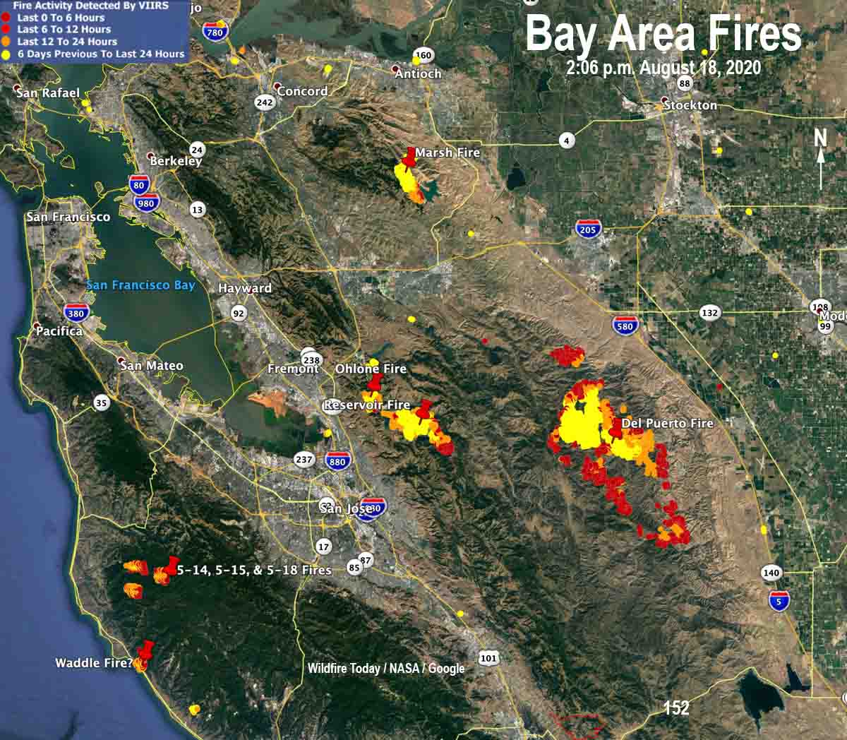
Map of the LNU Complex of fires at 2:06 p.m. PDT August 18, 2020.

Most of the wildfires in the LNU Complex were very active Tuesday. Based on data from a satellite at 2:06 p.m. the Del Puerto Fire especially increased in size.

(To see all of the articles on Wildfire Today about the lightning-caused wildfires in California, including the most recent, click HERE.)
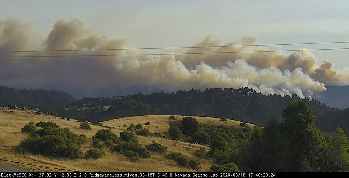
Waddle, 5-14, 5-15, and 5-18 fires
Photo from the Black Mountain camera looking southwest, in the general direction of the Waddle, 5-14, 5-15, and 5-18 fires at 5:46 p.m. PDT August 18, 2020.

August 18, 2020  |  7:43 a.m. PDT

map fires bay area california
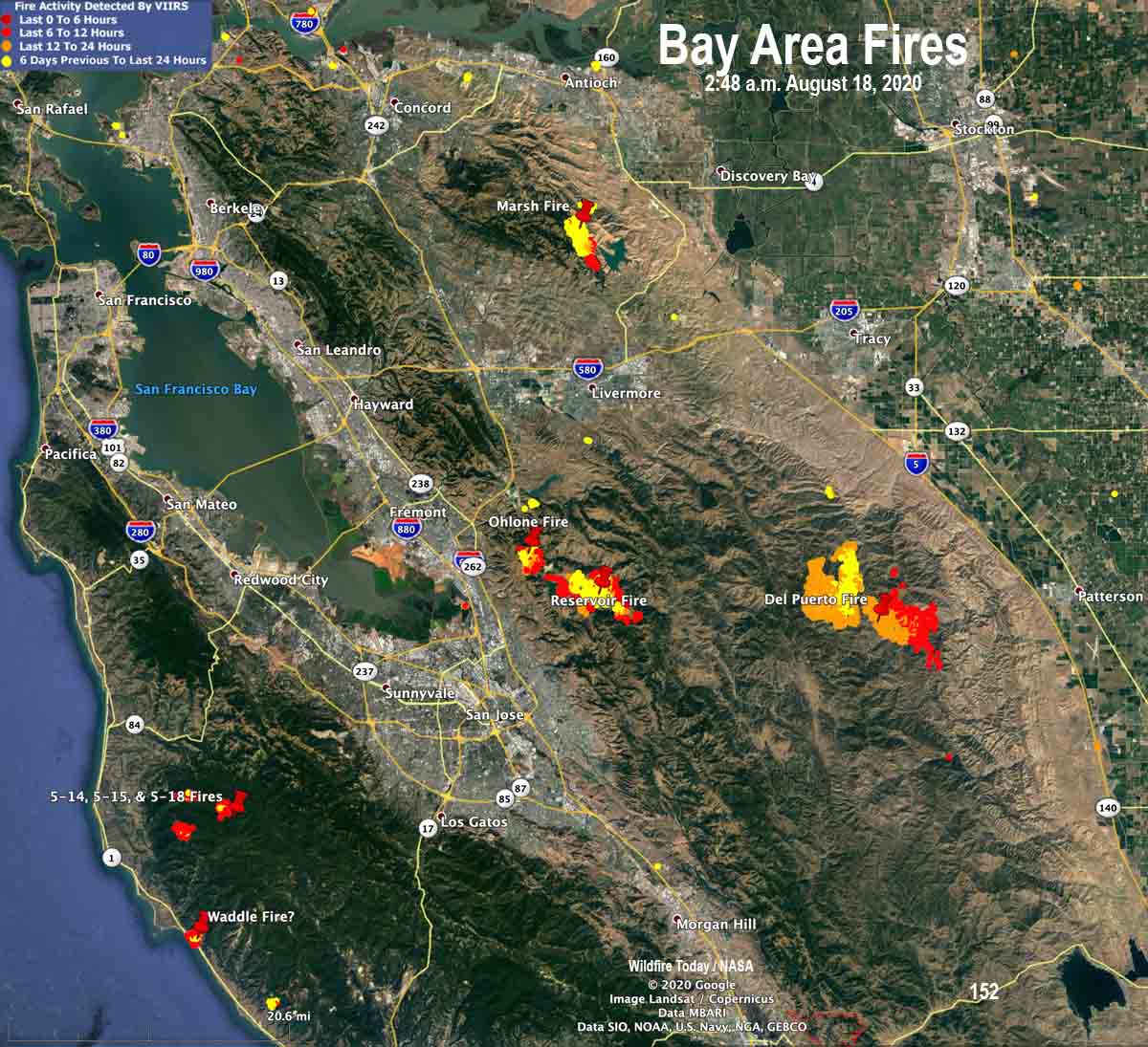
The map shows heat detected by a satellite on wildfires in the San Francisco South Bay Area at 2:48 a.m. PDT August 18, 2020. The names of some of the fires have changed.

Most of the wildfires that started in the San Francisco Bay area in the last three days that escaped initial attack and were already large by Monday evening continued to grow into Monday night, according to heat data collected by a satellite at 2:48 a.m. PDT Tuesday.

At least 16 fires north and south of Livermore are being managed as one “complex”, the SCU Lightning Complex. SCU is the CAL FIRE unit responsible for the counties of Santa Clara, Alameda, Contra Costa, western Stanislaus, and San Joaquin. Some of the names of the individual fires have changed in the last 24 hours, but the largest blazes in the complex are Marsh, Ohlone, Reservoir, and Del Puerto.

Very little detailed information is available about the individual fires.

The Del Puerto Fire, formerly part of the Canyon Zone Fires, is about 10 miles west of Patterson and about three miles northwest of Diablo Grande. With all the name changes the size is not clear, but it is likely 5,000 to 15,000 acres.

The Ohlone and Reservoir Fires southeast of Fremont are adjacent to the Calaveras Reservoir three to seven miles east of the 680 freeway.

Fires that have been grouped into the CZU August Lightning Complex include the Waddle, 5-14, 5-15, and 5-18 Fires, plus other smaller fires. CAL FIRE says they total about 1,000 acres.

Outside of the South Bay area there are many other fires. Further north there are more than 60 fires combined in Butte and Napa Counties, for example.

There are reports that competition for firefighting resources is intensifying as requests placed by some incident commanders are unable to be filled (UTF). Firefighters in some cases are being asked to work double shifts. This situation is unlikely to improve soon, based on the extraordinary heat predicted for this week.


August 17, 2020  |  7:21 p.m. PDT
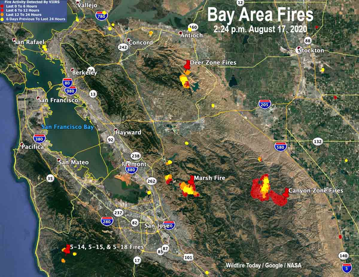
map fires bay area california
The map shows some of the significant wildfires that have started in the last few days in the Bay Area. Updated August 17, 2020 with satellite heat data from 2:24 p.m.

The map above is an updated version of the one below. The satellite heat data from 2:24 p.m. August 17 shows that the Canyon Zone Fires are growing rapidly toward the southeast and the west.

The Deer Zone Fire west of Los Vaqueros Reservoir was also active on the south side, but not to the same degree. It was mapped at 1,161 acres.

The Marsh Fire east of Milpitas was active at 2:24 p.m. Monday and has burned 1,775 acres.

The three fires oddly named 5-14, 5-15, and 5-18 did not create enough heat to be picked up during the latest satellite overflight at 2:24 p.m. Monday. They are about 5 miles east of Pescadero.


August 17, 2020 | 4:14 p.m. PDT
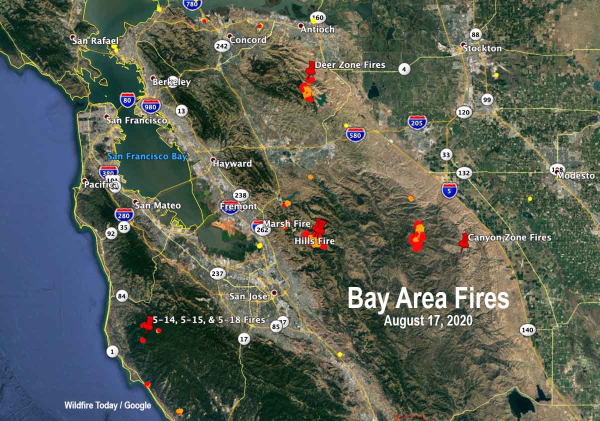
map fires bay area california
The map shows some of the significant wildfires that have started in the last few days in the Bay Area. Updated August 17, 2020. Red and yellow dots indicate heat detected by a satellite.

A rare series of intense summer thunderstorms passed through the San Francisco Bay Area Sunday morning and Monday morning. Some of the cells passed through so quickly there was little chance for precipitation.
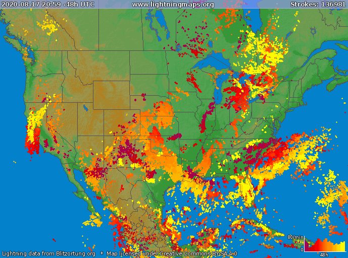
lighting strikes 48-hour period california bay area
Lightning strikes during the 48-hour period ending at 12:59 p.m. PDT August 17, 2020. The yellow strikes are the most recent.

Numerous wildfires ignited and while not all of them have been investigated, lightning is the likely cause for many. Combined with winds that accompanied the storms with gusts of 50 to 70, very high temperatures, and a Red Flag Warning, there are so many fires now that they are difficult to track, at least from this writer’s vantage point.

The southern Bay Area has quite a few and there are others in the North Bay and Napa area.

There is competition for firefighting resources. Some of the incident commanders placing orders for aircraft, dozers, engines, or crews are at times being told that a particular order can’t be filled at that time, or there may be a lengthy delay.

From the Washington Post:

In California, the heat resulted in scores of record highs over the weekend including around Los Angeles, the San Francisco Bay area and Sacramento. Early Sunday morning, a bizarre “heat burst” raised the temperature 20 degrees in two hours in Fairfield, about 40 miles northeast of San Francisco. The temperature shot from around 80 to 100 degrees in the hours around sunrise.

The National Weather Service in San Francisco issued an unusually large severe thunderstorm warning that covered more than 7,000 square miles from Monterey Bay to the Bay Area and north into Napa Valley. The office warned of “erratic outflow wind gusts of 50 to 70 mph wind gusts, [and] frequent lightning.” The warning, the largest ever issued by that office, was six times larger than the state of Rhode Island.

“This 20-year forecaster cant recall such a widespread [thunderstorm] event on the heels of such a heat wave,” wrote one meteorologist in the office forecast discussion late Sunday.

We will add to this post later with more details about individual fires.

River Fire prompts evacuations south of Salinas, California

August 17, 2020  |  6:22 p.m. PDT

Map River Fire at 2:28 p.m. PDT August 17, 2020
Map of the River Fire at 2:28 p.m. PDT August 17, 2020.

Not much additional information is available about the River Fire. Monterey County has current evacuation information. CAL FiRE has not updated the size since they announced it was 2,800 acres this morning.

(To see all of the articles on Wildfire Today about the lightning-caused wildfires in California, including the most recent, click HERE.)

Five structures have been damaged and there have been four “Confirmed Fire Personnel and Civilian Injuries” according to CAL FIRE.

Resources assigned include 10 hand crews, 2 helicopters, 55 fire engines, 9 dozers, and 6 water tenders for a total of 520 personnel.


August 17, 2020  |  7:13 a.m. PDT

map River Fire Salinas California
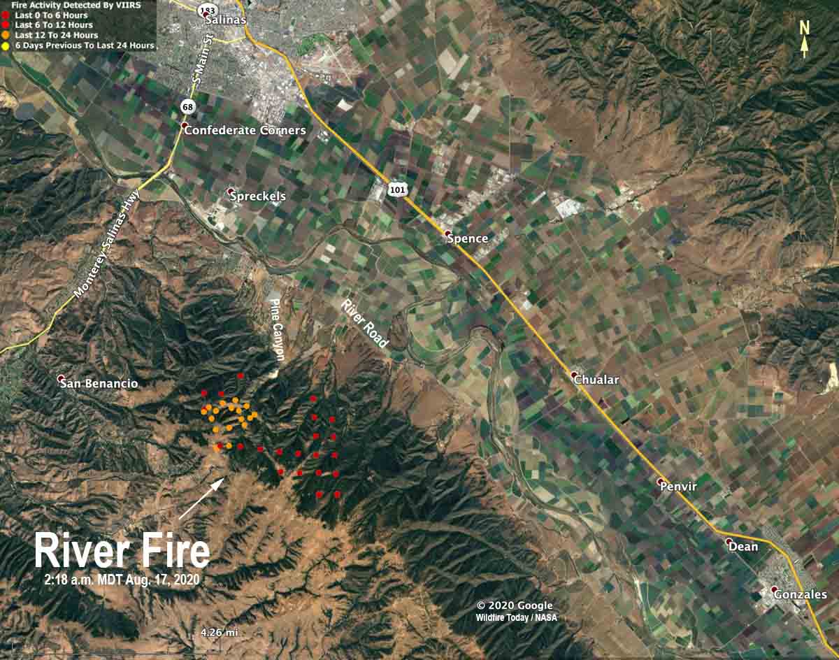
The red and yellow dots on the map represent heat detected by a satellite on the River Fire at 2:18 a.m. PDT August 17, 2020. The locations are estimates and the fire has continued to spread since then.

Monday morning at 6 a.m. PDT CAL FIRE reported that the River Fire five miles south of Salinas has burned 2,800 acres and threatens 1,500 structures. Five structures have been damaged but none destroyed. Four firefighters have suffered heat-related injuries.

The fire has crossed Pine Canyon Road, CAL FIRE said, and is moving south toward River Road.

Mandatory evacuations were in effect at 6 a.m. PDT August 17 for Pine Canyon Road, Parker Road, Laurel Lane, and Trimble Hill Lane. The evacuation center is at Buena Vista Middle School, 18250 Tara Drive in Salinas. More information about evacuations can be found at CAL FIRE.


August 16, 2020 | 8 p.m. PDT

map River Fire
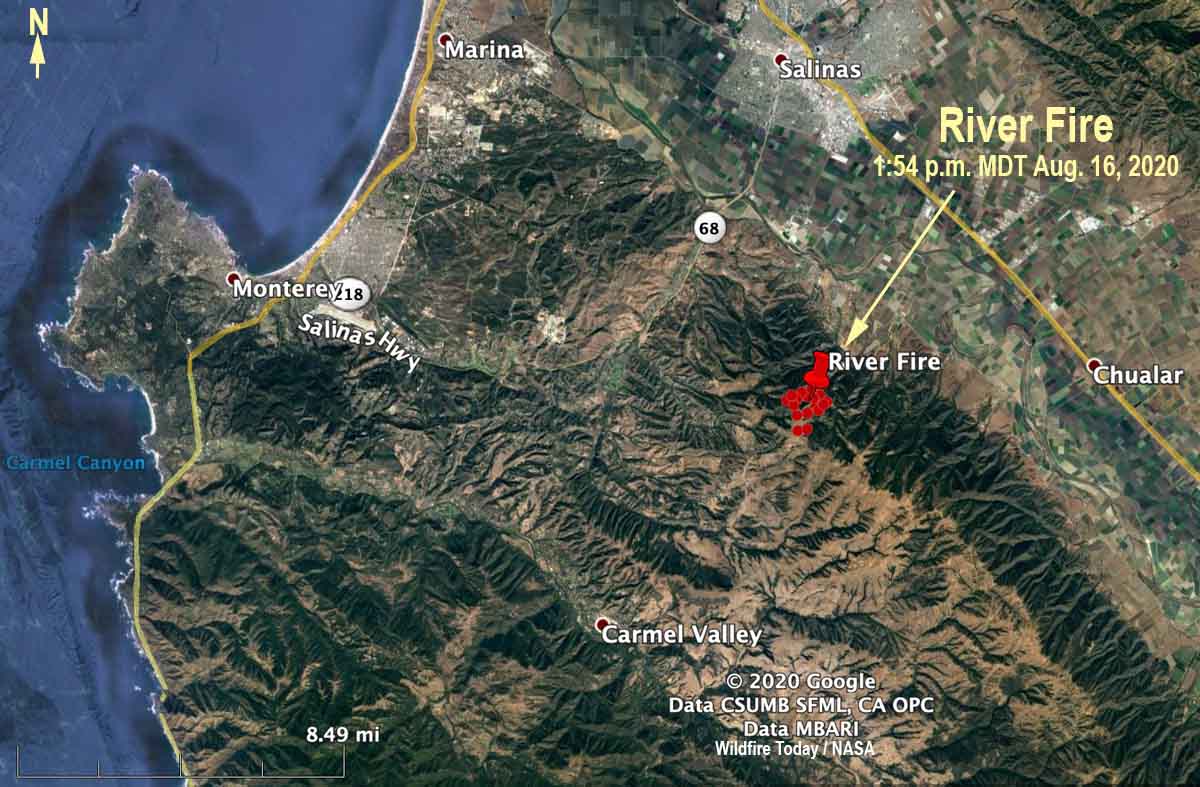
The red dots represent heat detected by a satellite on the River Fire at 1:54 p.m. PDT August 16, 2020.

CAL FIRE said at 5:40 p.m. Sunday that the River Fire reported at 3:14 a.m. PDT Sunday morning had burned 500 acres. It is in northern California about 5 miles south of Salinas and 6 miles northeast of Carmel Valley. Evacuations are in effect.

Sunday afternoon the wind recorded at the Rana Creek Tower near the fire was out of the north at 6 to 12  mph with gusts between 12 and 18. After 6 p.m. it switched to come out of the southwest at 10 mph with gusts to 13, pushing the fire to the northeast toward the valley. The relative humidity in the afternoon was around 30 percent with the temperature in the high 80s.

The forecast for Monday is for a high temperature around 90, relative humidity in the afternoon of 35 percent, and wind out of the west at 5 to 10 with gusts up to 21 in the afternoon.

The area has not been visited by fire for many years, so there should be abundant fuel available, offering firefighters a high resistance to control.

NWS issued fire tornado warning for Loyalton Fire northwest of Reno Saturday

At least five tornado-strength/scale vortices are likely to have occurred in the fire Saturday

August 16, 2020 | 5:04 p.m. PDT

Fire tornado Loyalton Fire
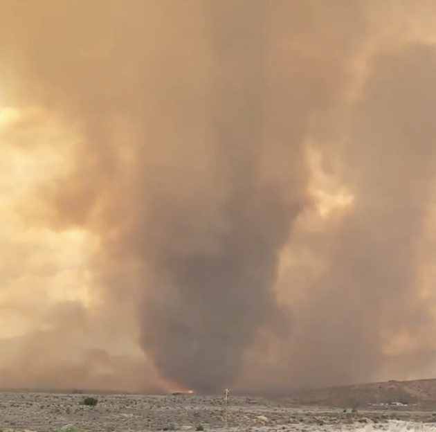
Fire tornado on the Loyalton Fire, by @DVRockJockey August 15, 2020.

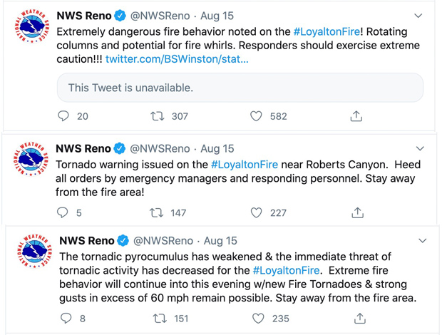
On August 15 meteorologists with the National Weather Service in Reno observed on radar a very rare fire tornado in real time at the Loyalton Fire about 12 miles northwest of the city. They used emergency warning systems to get the word out as quickly as possible to firefighters and the general public. It is believed that this is the first time a real time warning for this type of event has ever happened, at least in the United States.

They also sent out tweets, of course:

NWS tweets fire tornado

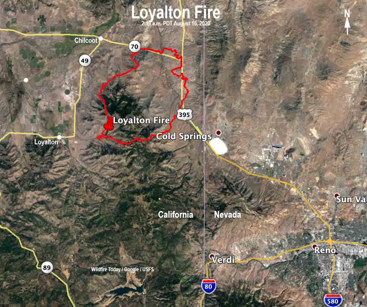
Loyalton Fire map
Map of the Loyalton Fire the morning of August 16, 2020, time uncertain, but possibly about 2 a.m.
The Loyalton Fire started at about 4:30 p.m. August 14 east of the town of Loyalton and southwest of Mount Ina Coolbrith. It burned north and east adjacent to the areas of Beckwourth Pass and Hallelujah Junction. Early Sunday morning it was estimated at 29,829 acres. More information about the Loyalton fire on Wildfire Today.

A fire tornado is just like it sounds — a large column of rotating air over a vegetation fire. Inside it and around it are extremely strong winds, very high temperatures, and flying debris.

On July 26, 2018 a firefighter was killed as a fire tornado burned and scoured a mile-long path as the Carr Fire moved into Redding, California. A Redding Fire Department Inspector was burned over in his truck and died on Buenaventura Boulevard. Three dozer operators were entrapped and one of them was also killed.

According to a Green Sheet report by CAL FIRE the conditions that resulted in the entrapment of three dozers and the Redding Fire Department Fire Inspector that day were due to the fire tornado — a large rotating fire plume that was roughly 1,000 feet in diameter. The winds at the base were 136-165 mph (EF-3 tornado strength), as indicated by wind damage to large oak trees, scouring of the ground surface, damage to roofs of houses, and lofting of large steel power line support towers, vehicles, and a steel marine shipping container. Multiple fire vehicles had their windows blown out and their bodies damaged by flying debris.

The strong winds caused the fire to burn all live vegetation less than 1 inch in diameter. Peak temperatures likely exceeded 2,700 °F.

Here is an excerpt from an article in the Washington Post about the fire tornados yesterday:

Fire tornadoes in and of themselves are rare; being able to detect them in real time on radar is something new. Wendell Hohmann is the meteorologist at the Reno office who issued the precedent-setting warning. He described it as a “once-in-a-lifetime, career event.”

“We were just trying to get the message out of the extreme fire behavior from this fire given the rotation and the tornadic potential,” Hohmann said. “We figured we could do a severe [thunderstorm warning], but we decided to do a tornado warning to get [the emergency alert system] and [wireless emergency alerts] to activate.”

Matthew Cappucci believes at least five tornado-strength/vortices are likely to have occurred on the Loyalton Fire August 15.

The news media sometimes calls any little fire whirl a “fire tornado”, or even a “firenado”. These and related terms (except for “firenado”) were, if not founded, at least documented and defined in 1978 by a researcher for the National Weather Service in Missoula, David W. Goens. He grouped fire whirls into four classes:

  1. Fire Devils. They are a natural part of fire turbulence with little influence on fire behavior or spread. They are usually on the order of 3 to 33 feet in diameter and have rotational velocities less than 22 MPH.
  2. Fire Whirls. A meld of the fire, topograph, and meteorological factors. These play a significant role in fire spread and hazard to control personnel. The average size of this class is usually 33 to 100 feet, with rotational velocities of 22 to 67 MPH.
  3. Fire Tornadoes. These systems begin to dominate the large scale fire dynamics. They lead to extreme hazard and control problems. In size, they average 100 to 1,000 feet in diameter and have rotational velocities up to 90 MPH.
  4. Fire Storm. Fire behavior is extremely violent. Diameters have been observed to be from 1,000 to 10,000 feet and winds estimated in excess of 110 MPH. This is a rare phenomenon and hopefully one that is so unlikely in the forest environment that it can be disregarded.”

It was just two days ago that I wrote extreme fire behavior and massive pyrocumulus are becoming much more frequent. If we are going to see more fire tornados, that is a scary thought. The west coast is expected to have very high temperatures this week.

Loyalton Fire
Loyalton Fire at 1:39 p.m. PDT August 15, 2020, looking north.

Thanks and a tip of the hat go out to Chris and SST.

Helicopters help suppress fire that burned into Oregon junkyard

August 16, 2020 | 3:34 p.m. PDT

Juniper Fire Bend Oregon junkyard
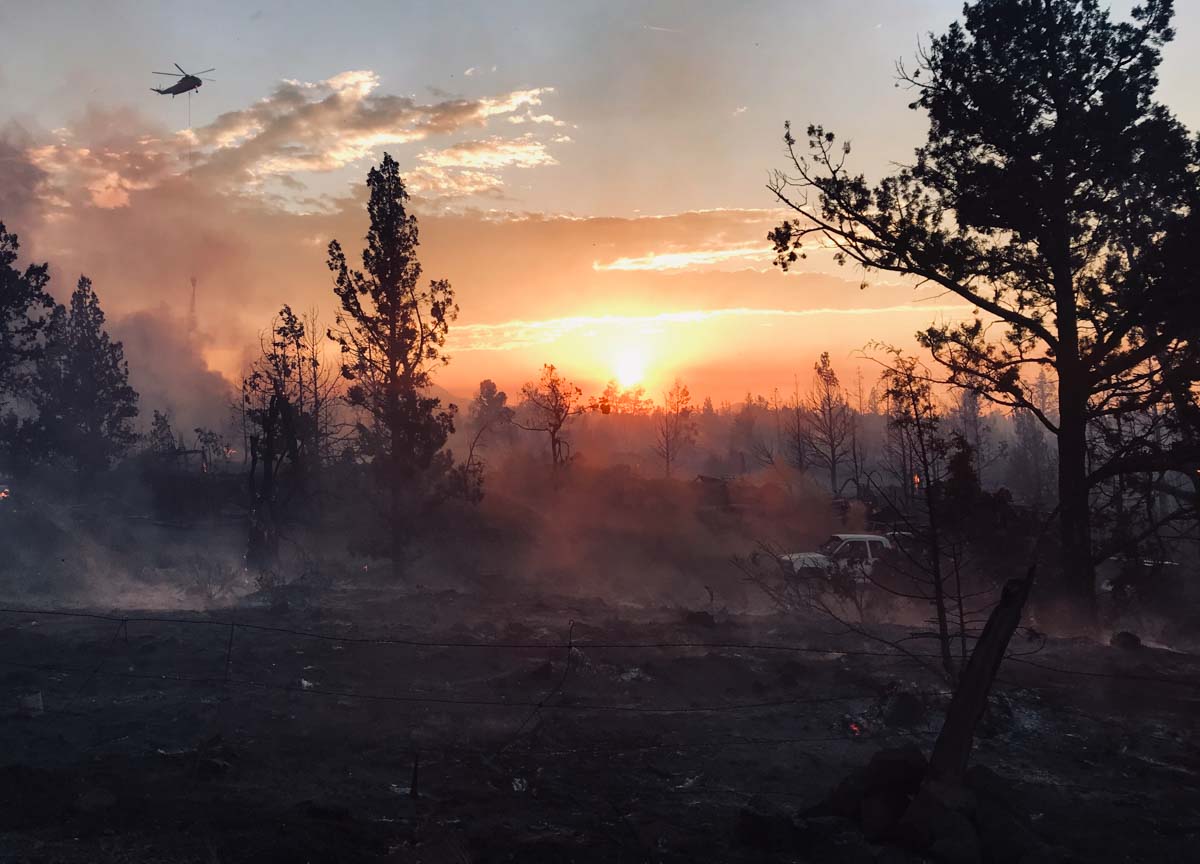
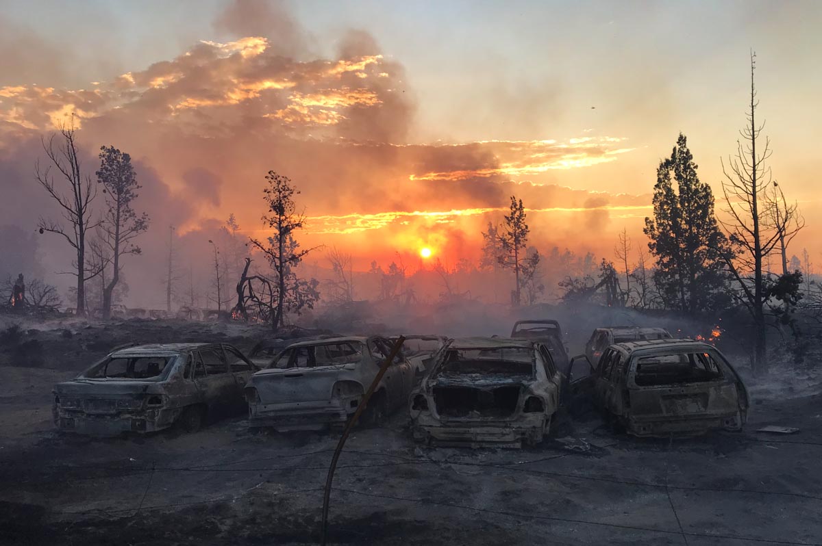
An S-61 helicopter drops water on the Juniper Ridge Fire, August 15, 2020. Photo by Brendan O’Reilly.

(This article first appeared on Fire Aviation)

 A vegetation fire that spread into an auto wrecking yard Saturday was attacked by firefighters on the assisted by at least five aircraft. Hundreds of homes were threatened including a mobile home park next door.

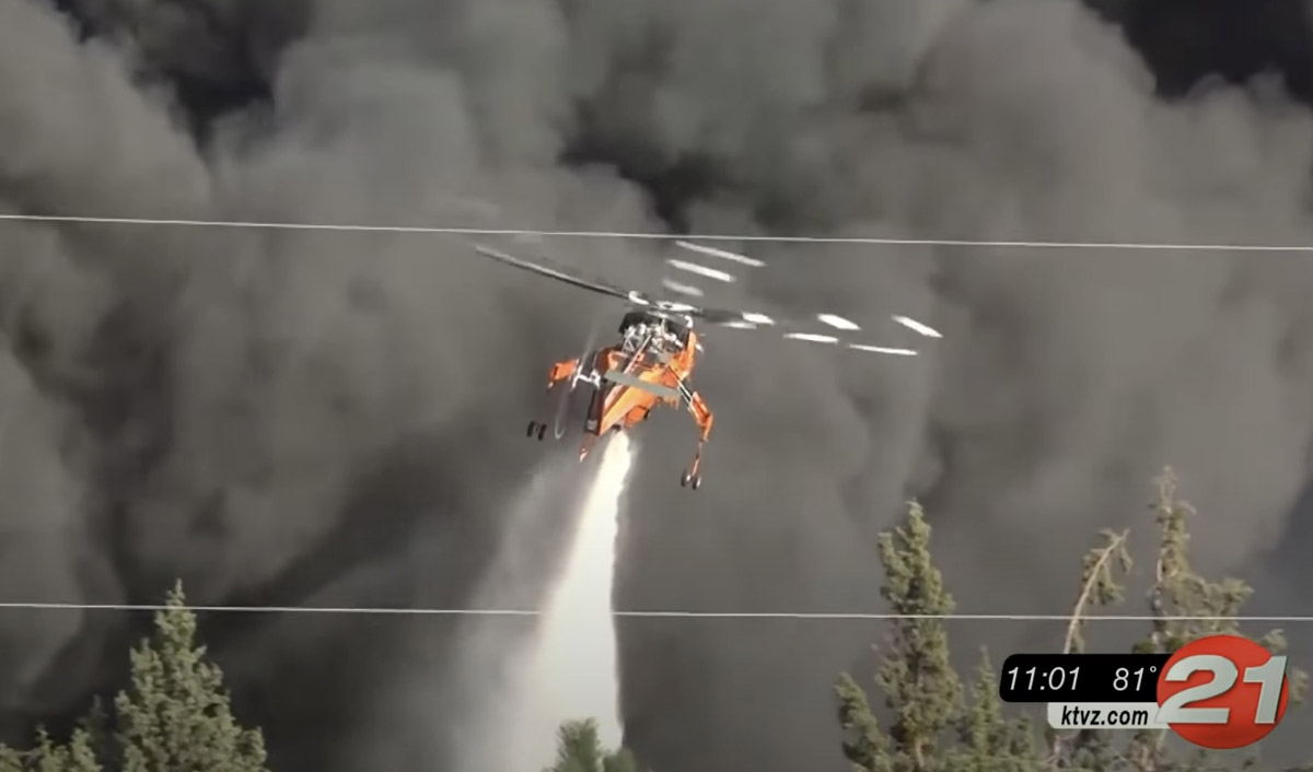
Footage from KTVZ showed numerous water drops by an Air-Crane, Helicopter 3AC. At least two Single Engine Air Tankers also worked the fire, as well as two other helicopters, an S61 and a third that may have been a Bell 205, said Brendan O’Reilly, Superintendent of the Prineville Hotshots who was on scene.

Helicopter 3AC drops on the Juniper Fire
Helicopter 3AC drops on the Juniper Fire August 15, 2020. Note the shadow of the helicopter on the thick smoke. Screenshot from KTVZ video.

Numerous vehicles were on fire in the wrecking yard producing a thick column of black smoke.

“Maybe 25 acres [were burning] in the wildland around several structures, and then about 10 acres in the junkyard although due to the thick toxic smoke and exploding airbags and tires, we couldn’t accurately map the whole perimeter on the ground,” Superintendent O’Reilly said. “I’d never personally seen helicopters used on a junkyard fire. The helicopters were much more effective than SEATs due to the thick black smoke column, but still couldn’t do much except limit spread to adjacent structures. It took structure engines with SCBAs to make any headway in the junkyard itself, but that was after hours of tires and airbags exploding. It was a very interesting evening.”

Juniper Ridge Fire, August 15, 2020 by Brendan O’Reilly.

“Due to the air attack resources we were able to make an aggressive stop on the fire,” said Trish Connolly, Battalion Chief for Bend County Fire Department. “Today we know that we lost two outbuildings and [and there was] damage to a commercial building.”

Evacuations were in effect while the fire was spreading but were lifted late in the day.

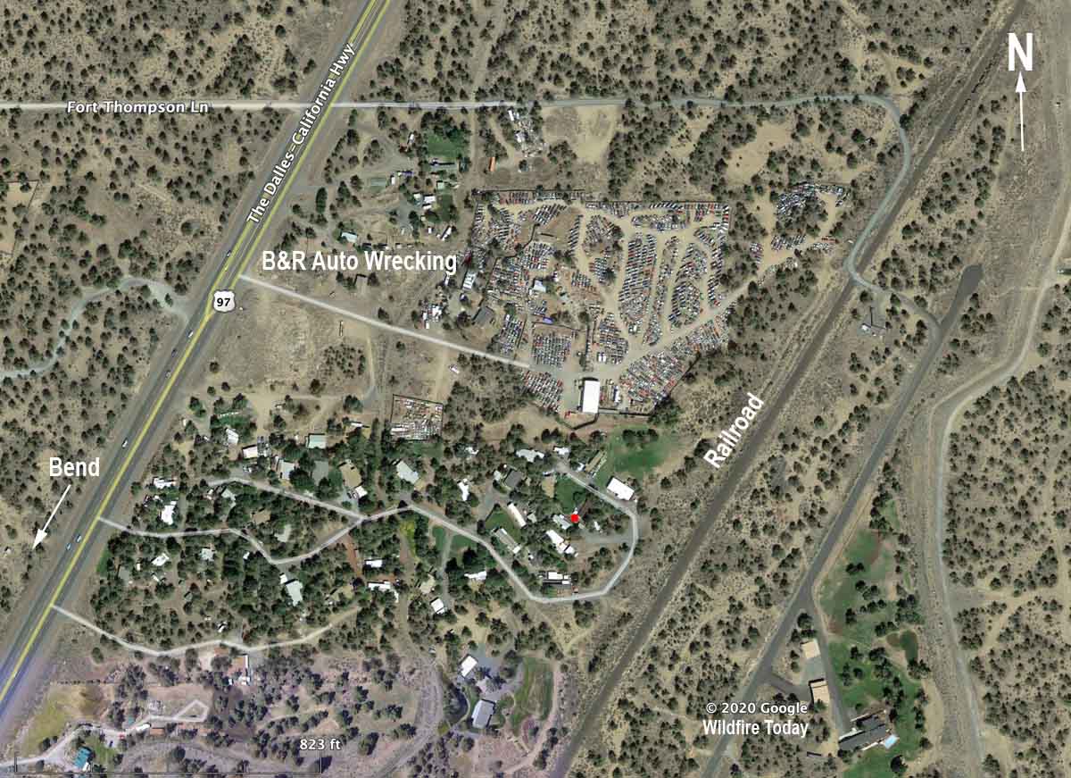
Early reports say the fire started east of the railroad that is just east of the wrecking yard.

Juniper Fire junkyard bend oregon
File photo of the Juniper Fire area, July 27, 2018. Google Earth.

The video below shows several drops by the Air-Crane helicopter, 3AC.

Thanks and a tip of the hat go out to Brendan.

Wildfire smoke forecast for 9 a.m. MDT August 16

August 15, 2020  |  6:46 p.m. MDT

wildfire fire smoke forecast for 9 a.m. MDT August 16, 2020
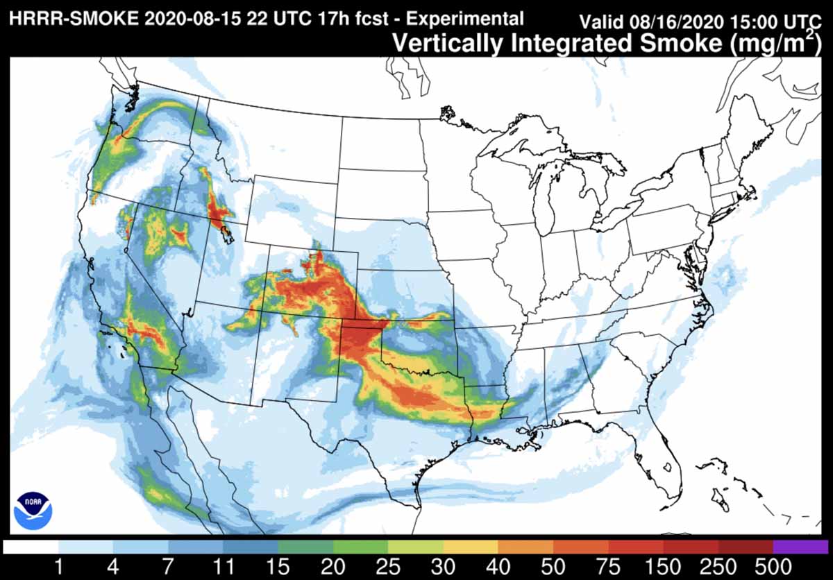
Smoke forecast for 9 a.m. MDT August 16, 2020. NOAA.

The map above is the forecast for the distribution of smoke from wildfires at 9 a.m. MDT August 16, 2020. Locations where it will be most noticeable include areas in Oregon, Washington, Idaho, Nevada, Arizona, New Mexico, Utah, Colorado, Nebraska, Oklahoma, Texas, Louisiana, and southern California.