Mine Draw Fire being fought 6 miles south of Mount Rushmore

In the Black Hills of South Dakota

(UPDATED at 3:36 p.m. MDT June 25, 2020)

Jim Strain who took this photo from the Fairburn, SD area, said it looked like this storm cell was over the Mine Draw Fire. Posted by Jim at 1:04 p.m. MDT June 25, 2020.

Custer State Park announced that as of 2 p.m. today the Mine Draw Fire is 100 percent contained. We are waiting to hear if the Governor has declared it officially contained.

That was around the time that a very large thunderstorm cell was centered over the fire. As of 3:18 p.m. 0.25″ of rain had been measured at the Custer State Park airport.

Mine Draw Fire rain
Radar shows rain over the Mine Draw Fire. Posted by Galen Hoogestraat at 1:32 p.m. MDT June 25, 2020.

(UPDATED at 12:14 p.m. MDT June 25, 2020)

The only official information available today about the Mine Draw Fire was issued by the South Dakota Governor’s office. The update said the  fire has burned 60 acres, which is a decrease from the Wednesday afternoon estimate of 150 acres.

The fire was reported at 11:19 a.m. June 24 in Custer State Park six miles south of Mount Rushmore.

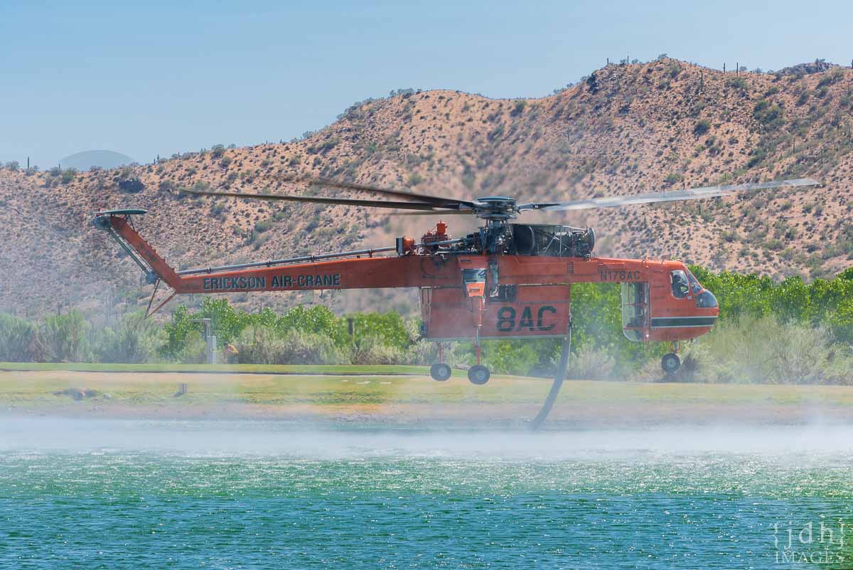
The statement from the Governor’s office said that in addition to the hand crews and fire engines, there are two Type 1 helicopters and one air attack plane on scene for a total of 117 personnel. Yesterday three Type 1 Hotshot crews were at the fire or en route.

A resident near the fire said that last night the wind in the fire area was calm and there was not much smoke. Another person who was farther way could clearly see the smoke column yesterday but early this morning none was visible.

The weather station at the Custer State Park airport recorded a maximum relative humidity overnight of 70 percent. At 11:18 a.m. MDT today it had dropped to 39 percent, the temperature was 83, and the wind was 12 mph out of the northeast gusting up to 21 mph. The forecast for the fire area at 5 p.m. calls for the temperature going down to 73, humidity 54 percent, and increasing cloud cover with showers and thunderstorms likely.

With the overnight conditions, the forecast, and the resources on hand, the firefighters could have a good chance of stopping the spread of the 60-acre fire today.


(UPDATED at 8:15 p.m. MDT June 24, 2020)

Two additional hotshot crews are en route to the Mine Draw Fire east of Custer, South Dakota — the Roosevelt Hotshots from Colorado and the Wyoming Hotshots.

The fire is half a mile north of the Legion Lake Fire that burned 54,000 acres in December, 2017.

The South Dakota Governor’s senior advisor and policy director, Maggie Seidel, said at 8:15 p.m. MDT Wednesday that the fire has burned 150 acres.

The customary system for distributing information about wildfires in the Black Hills is with local agency information officers coordinated through the Great Plains Interagency Dispatch Center. But for this fire, information is being controlled by Governor Kristi Noem’s office.


(Originally published at 5:37 p.m. MDT June 24, 2020)

Mine Draw Fire
Mine Draw Fire, June 24, 2020. Photo by Custer State Park.

Firefighters in the Black Hills are attacking a fire that was discovered at 11:19 Wednesday morning in Custer State Park six miles south of Mount Rushmore.

The Mine Draw Fire had grown to 150 acres by 4:30 p.m. and was being attacked by firefighters on the ground and in the air north of Highway 16A and east of Highway 87. The blaze is west of the Custer State Park maintenance shop on the north side of 87 and seven miles east of Custer.

Mine Draw Fire map
Map showing the location of the Mine Draw Fire June 24, 2020.

Scott Jacobson, a spokesperson for the Great Plains Interagency Dispatch Center said firefighting resources working on the fire included fire engines from several agencies, dozers, and the Tatanka Hotshots.

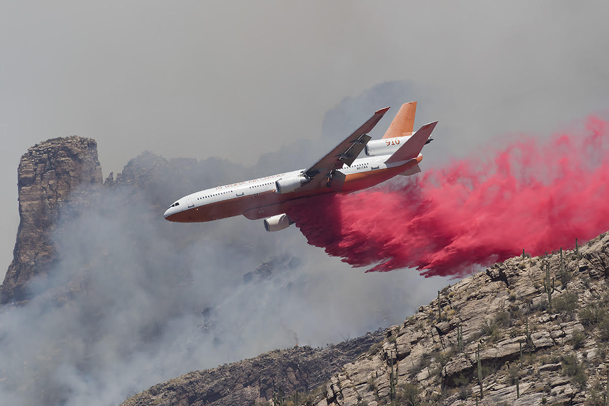
A variety of firefighting aircraft were seen over the fire Wednesday afternoon:

  • Two large air tankers: T-02, a BAe-146; and T-162, an RJ85; they were dispatched from Pueblo, CO and Rocky Mountain Metropolitan Airport near Denver, respectively.
  • Three Single Engine Air tankers, all Air Tractor 802s;
  • Two helicopters, a Sikorsky S-61A and an Airbus AS50;
  • Plus a lead plane and air attack.

The air tankers were refilling with retardant the Rapid City Air Tanker Base at the Regional Airport.

Mine Draw Fire aircraft
Aircraft over the Mine Draw Fire at 4:39 p.m. MDT June 24, 2020.

The Black Hills are in a moderate drought, and the weather Wednesday has been on the high side of moderate from a firefighters’ point of view. Since the fire started, the weather station not far away at the Custer State Park airport has recorded temperatures in the mid 80s, relative humidity around 30 percent, and winds out of the east or northeast at 4 to 8 mph gusting at 12 to 16 mph.

Bighorn Fire near Tucson grows to over 81,000 acres

Firing operations are being conducted to protect Saddlebrooke

(UPDATED at 7:53 a.m. MDT June 25, 2020)

Bighorn Fire Samaniego Peak
Bighorn Fire on Samaniego Peak, 6 p.m. June 24. Inciweb photo.

The Bighorn Fire north of Tucson was active Wednesday and Wednesday night. As firefighters worked on structure protection and fireline reinforcement in the Summerhaven and Willow Canyon areas, helicopters and air tankers successfully slowed fire spread and reduced fire intensity in the west fork of Sabino, Bird, and Rattlesnake canyons. Aerial firing operations in the Charouleau Gap area four miles east of Saddlebrook started around 5 pm.

(To see all articles about the Bighorn fire, including the most recent, click here.)

Bighorn Fire map Arizona Tucson
3-D map of the Bighorn Fire looking southeast. The red line was the perimeter at 9:46 p.m. MDT June 24, 2020. The green line was the perimeter about 24 hours before.

Firing operations also were carried out along the Catalina Highway near Spencer Peak and Spencer Canyons one mile east of Summerhaven and reinforced firelines near Dodge Wash two miles south of Oracle.

Bighorn Fire map Arizona Tucson
Map of the Bighorn Fire. The red line was the perimeter at 9:46 p.m. MDT June 24, 2020. The green line was the perimeter about 24 hours before.

A mapping flight Wednesday night determined that the Bighorn Fire had burned 81,702 acres, a 24-hour increase of over 7,000 acres.

Evacuations are in effect. For more information visit pima.gov/bighorn or pinalcountyaz.gov/emergencymanagement


(Originally published at 9:47 a.m. MDT June 24, 2020)

Bighorn Fire map Arizona
3-D map of the Bighorn Fire looking southeast. The green line was the perimeter June 19, 2020. The red line was the perimeter at 10:52 p.m. MDT June 23, 2020. The shaded areas represent intense heat detected by the mapping sensors in the fixed wing aircraft.

The Bighorn Fire has grown significantly in recent days to the north, west, and east. Since June 19 it has spread two miles to the west, five miles north, and three miles east.

During a mapping flight at 10:52 p.m. June 23 the fire was two miles south of Oracle, three miles south of Highway 77, and 2.5 miles southeast of Saddlebrooke. The fire has now burned 74,547 acres after starting from a lighting strike on June 5. About $21 million has been spent on managing the blaze.

A DC-10 Very Large Air Tanker drops retardant near Pontatoc Ridge on the Bighorn Fire north of Tucson, June 11, 2020. Photo by Tim Peterson.

On Tuesday structure protection and containment work supported by helicopter bucket drops focused around Mt. Lemmon, Summerhaven, and Willow Canyon. Low-intensity firing operations removed pockets of unburned fuels in these areas. Aerial firing operations were conducted south of Oracle. The efforts near Oracle Ridge and Rice Peak are intended to reduce the risk of uncontrolled fire growth to the north in the coming days.

Evacuations are in effect. For more information visit pima.gov/bighorn or pinalcountyaz.gov/emergencymanagement

Resources assigned to the fire Tuesday included 20 hand crews, 81 fire engines, 6 dozers, 19 water tenders, and 10 helicopters for a total of 876 personnel. The number of personnel assigned has decreased by 112 since Monday. There have been 4 minor injuries.

Bighorn Fire Arizona
Bighorn Fire as seen from Saddlebrook June 23, 2020. Photo by Molly Hunter.

Night shift on the Mangum Fire, northern Arizona

Globe Hotshots, Mangum Fire wildfire Arizona
Globe Hotshots, Mangum Fire, June 18, 2020. Photo by Mike McMillan. The parallel line pattern is a result of swinging the drip torch from side to side while walking.

Strategic burning operations are often conducted at night, giving firefighters more control over the behavior of the fire they are igniting.

Mike McMillan, a Task Force Leader on the Mangum Fire in northern Arizona, sent us these photos of the Globe Hotshots during a recent burning operation on the east side of the fire.

Thanks Mike!

Globe Hotshots, Mangum Fire wildfire Arizona
Globe Hotshots, Mangum Fire, June 18, 2020. Photo by Mike McMillan.

Central Fire spreads east from New River, AZ

Central fire mapped Sunday night at 4,517 acres

(UPDATED at 11:40 a.m. MDT June 22, 2020)

Central Fire Bush Bighorn Arizona wildfire map
3-D map showing the Central Fire which was mapped at 12:08 a.m. MDT June 22, 2020. The Bush and Bighorn Fires can be seen in the distance.

The Central Fire just east of New River, Arizona spread to the east Sunday to the top of New River Mesa, growing to 4,517 acres according to a mapping flight at 12:08 a.m Monday.

At a virtual community meeting Sunday night Ralph Lucas, the Operations Section Chief of Alan Sinclair’s Type 1 incident management team running both the Central and Bush Fires, said he did not expect the Central Fire to grow much more:

But when I last spoke to the Incident Commander on the Central Fire, he was confident with what they had going on, and thinks that we might be able to get around this thing and not see a drastic increase in acreage, but only time will tell depending on the weather and the wind.

Skycrane “Isabelle” N178AC, a Sikorsky S-64F fire wildfire
Skycrane “Isabelle” N178AC, a Sikorsky S-64F from Erickson Incorporated fills her 2,500 gallon tank at the Rancho Manana Golf Club while fighting the nearby Central Fire burning in the Tonto National Forest near New River, AZ on June 21, 2020. Photo by John Hall.


(Originally published at 12:47 p.m. MDT June 21, 2020)

DC-10 air tanker Central Fire
Air Tanker 914, a DC-10, drops retardant on the Central Fire, June 20, 2020. Photo by JDH Images.

Eleven months ago firefighters battled a wildfire north of Phoenix about 35 miles north of Phoenix, 4 miles east of Interstate 17. There was confusion about the name of the fire, switching from Central to Daisy and back to Central.

Saturday the same thing happened in the same location. A fire started in the footprint of the 2019 Central Fire. The name changed from Central to Daisy and back to Central.

Central Fire Arizona Phoenix
Red dots represent heat on the June 20, 2020 Central Fire detected by a satellite at 3:21 p.m. MDT June 20, 2020. Retardant from the July 20, 2019 Central Fire is visible in the background satellite photo taken August 12, 2019.

In the satellite photo above taken August 12, 2019, 23 days after the first Central Fire, you can make out retardant which was dropped by air tankers. Within those retardant lines are superimposed red dots representing heat on the June 20, 2020 Central Fire detected by a satellite at 3:21 p.m. MDT June 20, 2020.

Last year’s Central Fire burned between 503 and 800 acres.

Central Fire information Arizona

The Southwest Coordination Center lists the current Central Fire at 2,000 acres. Since the Saturday afternoon overflight, satellites have not been able to detect any large heat sources on the fire, but it is likely burning, or was burning, in light fuels such as grass, and cooled quickly between overflights.

Last year we made the map below:

Map Arizona location Central Fire
Map showing the location of the Central Fire 35 miles north of Phoenix at 3:21 p.m. MDT July 20, 2019.

The Incident Management Team on the Bush Fire northeast of Phoenix is managing the Central Fire.

The Bush Fire grew Saturday by 9,171 acres to bring the total up to 184,531 acres. Firefighters have had success in recent days stopping the spread at Highways 87 and 188. They are closely watching the south side as it backs slowly downhill through light vegetation to Apache Lake and the Salt River.

Central and Bush Fires Phoenix
The Central and Bush Fires in the Phoenix Area, June 21, 2020.

Bighorn Fire north of Tucson grows to 42,798 acres

Firefighters have been conducting back burns out ahead of the fire

(Originally published at 10:09 a.m. MDT June 20, 2020)

3-D map of the Bighorn Fire
3-D map of the Bighorn Fire looking southeast at 10:12 pm MDT June 19, 2020.

The Bighorn Fire north of Tucson, Arizona grew by 5,740 acres Friday to bring the total up to 42,798 acres.

Firefighters have been conducting back burns out ahead of the fire which they hope will serve as barriers to fire spread south of the community of Oracle along Old Mount Lemmon Highway near Peppersauce. They have also been constructing firelines on the west side of the Catalina Highway.

(To see all articles on Wildfire Today about the Bighorn Fire including the most recent, click here.)

For information about evacuations in Pima County contact visit pima.gov/bighorn. In Pinal County check the Sheriff’s Office Facebook page.

Map of the Bighorn Fire
Map of the Bighorn Fire. by the Incident Management Team, June 20, 2020.

The map below shows the growth of the Bighorn Fire over a 24-hour period.

Bighorn Fire Map
The red line was the perimeter of the Bighorn Fire detected by a mapping flight at 10:12 p.m. MDT June 19. The yellow line was the perimeter about 24 hours before.

Firefighting resources assigned to the fire include 20 hand crews, 64 engines, 18 water tenders, 6 dozers, and 7 helicopters for a total of 894 personnel.

Bighorn Fire Tanker 910, a DC-10
Tanker 910, a DC-10 operated by 10 Tanker Air Carrier drops on the Bighorn Fire. N612AX. Ned Harris photo.

Bighorn Fire north of Tucson burns past Mt. Lemmon

The fire grew to over 31,000 acres Wednesday

(UPDATED at 12:10 p.m. MDT June 19, 2020)

Bighorn Fire Map
The red line was the perimeter of the Bighorn Fire detected by a mapping flight at 9 p.m. MDT June 18. The yellow line was the perimeter detected by a mapping flight about 24 hours before.

Thursday’s decreasing winds gave firefighters on the Bighorn Fire somewhat of a break, at least when compared with the difficult conditions on Wednesday that pushed the blaze northeast over Mt. Lemmon. Hand crews and personnel on fire engines were able to make progress, said Operations Section Chief Travis Mayberry.

(To see all articles on Wildfire Today about the Bighorn Fire including the most recent, click here.)

The lower wind speeds Friday could result in smoke being more visible in the communities near the fire. Weather forecasters expect temperatures of around 100 degrees with very low relative humidity.

Thursday night the fire was mapped at 37,058 acres, an increase of 5,850 acres in 24 hours.

Bighorn Fire Tanker 105 Tanker 10 BAe-146
Tanker 105 (foreground), an MD-87 (N295EA) operated by Erickson Aero Tanker, and Tanker 10, a BAe-146 (N472NA) operated by Neptune Aviation maneuver over the Bighorn Fire. Ned Harris photo.

Fire managers expect growth to the northeast in Cañada del Oro and Alder Canyons on Friday. Crews working south of Oracle and San Manuel will tie in containment lines today, in preparation for additional firing operations Friday evening. Firefighters on Mt. Lemmon are using an assortment of tools, including controlled burning, to protect the communities along the Catalina Highway.

As the high winds that had been keeping the fire burning on Samaniego Ridge and the top of Ventana Canyon subside, the fire may move downslope at a moderate pace. Firefighters will have to wait to engage some sections of the fire until after it transitions onto less steep terrain.


(Originally published at 1:35 p.m. MDT June 18, 2020)

map Bighorn Fire Arizona Tucson
3-D map of the perimeter of the Bighorn Fire mapped by fixed wing aircraft at 10:33 p.m. MDT June 17, 2020.

Since it started June 5 from a lightning strike the Bighorn Fire five miles north of Tucson has been adding less than 4,000 acres every day, until Wednesday when strong winds pushed it past Mt. Lemmon, growing by about 13,000 acres to bring the total up to 31,208 acres.

Firefighting resources assigned to the fire include 15 hand crews, 60 engines, 8 helicopters, 12 water tenders, and 6 dozers.

From the Incident Management Team Thursday morning:

“Today, fire managers anticipate the fire will move towards Charouleau Gap, depending on wind direction and temperatures. Fire crews and air support are in place preparing and widening fire lines for this expected spread of the fire. On Mt. Lemmon, the fire moved through Oracle Ridge and generated spot fires in Stratton Canyon. Expect highly visible smoke as those areas burn together today. Crews working overnight implemented controlled burns along the Catalina Highway corridor. Firing operations will continue today, if necessary, to protect values at risk.

“Air operations including fixed-wing airtankers were up early this morning, dropping water and fire retardant to slow the fire’s spread. Winds will continue to be a factor today, but less so than yesterday. The fire burning in the Ventana Canyon area and along Samaniego Ridge will be monitored by air support today. Minimal downslope backing of the fire is anticipated in that area. Crews will tie together the two containment lines north of the fire perimeter to protect the communities of Oracle and San Manuel.”

map Bighorn Fire Arizona Tucson
Perimeter of the Bighorn Fire mapped by fixed wing aircraft at 10:33 p.m. MDT June 17, 2020.
Bighorn Fire Arizona Tucson wildfire
Bighorn Fire, undated or credited Inciweb photo
progression acres Bighorn Fire Arizona Tucson
Bighorn Fire Progression. By the Incident Management Team.