Fire on Easter Island damages iconic statues

Wildfire on Easter Island damages iconic statues. Municipalidad de Rapu Nui photo.

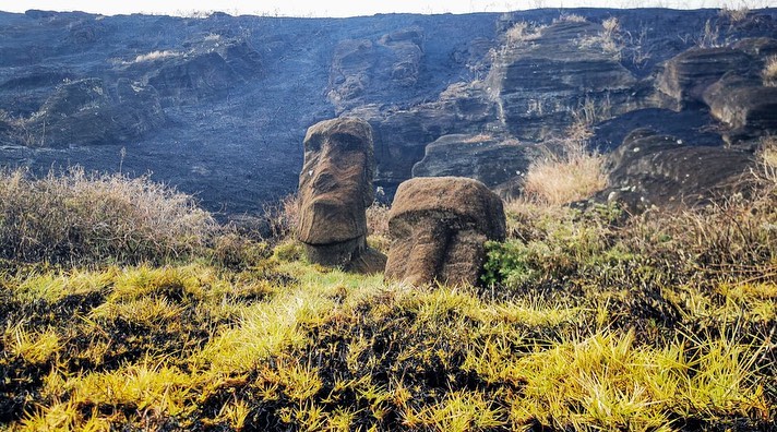
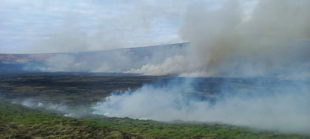
Approximately 80 of the famous stone figures on Easter Island were damaged by a wildfire on October 5 local authorities say. The statues, known as moai which range in size from 6 to more than 30 feet tall, were affected by the fire that burned about 148 acres of the Rapa Nui National Park on the island which is part of Chile. There are an estimated 416 moia in that area of the island.

Wildfire on Easter Island damages iconic statues. Municipalidad de Rapu Nui photo.

Moai are made of lapilli tuff, pyroclastic rock prone to fractures if exposed to high temperatures. A Polynesian society that had settled in the area around the year 300 built the shrines between the 10th and 16th centuries on what experts say is the most remote inhabited island on Earth.

Wildfire on Easter Island
Wildfire on Easter Island. Photo by Primera Compania de Bomberos de Isla de Pascua.

Ariki Tepano, with the indigenous Ma’u Henua community that manages the park, said the fire had done “irreparable” damage to the site.

“The moai are totally charred, and you can see the effect of the fire upon them,” he said in a statement.

Wildfire on Easter Island damages iconic statues. Municipalidad de Rapu Nui photo.

A shortage of volunteers made it difficult to contain the fire, according to the post by Rapa Nui.

Pedro Edmunds, mayor of Easter Island, attributed the origin of the flames to the burning of pastures “that some horse and cow farmers do on the island.” The Minister of Agriculture, Esteban Valenzuela, announced on Friday that the cause of the fire will be investigated and that Chile’s National Forestry Corporation (Conaf) will have a permanent forestry brigade on Easter Island throughout the year.

From EL PAÍS International:

Ninoska Huki, provincial head of Conaf on Easter Island, explained to Chile’s La Tercera news outlet that the corporation “hires brigades during forest fire seasons, and that begins in the second half of October until April,” so the brigade was not active. Chile, moreover, is one of the few countries in the world where firefighters work on a voluntary basis. And it is becoming increasingly difficult to get new young people to join the corps. From July 1, 2020, to April 21 of this year, 60 forest or vegetation fires occurred on the island, 13% less than in the same period of the previous year.

During his visit to Santiago, shortly after the island reopened to tourism after almost two and a half years of closure due to the pandemic, the mayor met with Chilean President Gabriel Boric and some of his ministers to request a budget readjustment for Easter Island. As Rapa Nui generates most of its income via tourism, the isolation left the community “bankrupt,” according to the municipality. Of the 800 park rangers hired to prevent fires, clean up and prevent tourists from damaging the statues in the 16,000-hectare park, there are now only 120. The island now receives only three flights weekly, for a total of 750 passengers, compared to the 14 flights of 8,000 total passengers that arrived before the lockdown. “Who is going to come to help put out fires if you don’t pay them? It’s that simple,” said the mayor, who was not granted the requested budget readjustment.

Wildfire on Easter Island damages iconic statues. Municipalidad de Rapu Nui photo.

Howard Fire ignites northeast of Ojai, Calif.

11:36 a.m. PDT Oct. 9, 2022

Howard Fire photo, 1020 a.m. Oct. 9, 2022
Howard Fire photo, looking west at 10:20 a.m. Oct. 9, 2022. FIRIS.

Aircraft were over the Howard Fire Sunday morning, including a lead plane and water-dropping helicopters.

The FIRIS OES 24 aircraft created an updated map at about 10 a.m. showing that the fire had grown to 85 acres, an increase of 10 acres since it was mapped Saturday evening.

The incident is 8 miles northeast of Ojai, California. It is burning on both sides of Sespe Creek and the 20W13 Road, 6 miles east of Highway 33.

FIRIS was able to see fire retardant around much of the fire as well as hand-constructed and dozer-constructed fire line on portions of the perimeter. The video below is from FIRIS.


7:15 p.m. PDT October 8, 2022

Howard Fire 3-D map 5:21 p.m. Oct. 8, 2022
Howard Fire 3-D map (in red) 5:21 p.m. Oct. 8, 2022

The Howard Fire started Saturday afternoon in a remote area 8 miles northeast of Ojai, California. It is burning on both sides of Sespe Creek and the 20W13 Road 6 miles east of Highway 33.

At about 5:50 the incident commander estimated it had burned 80 to 85 acres. About half an hour earlier it was mapped by the FIRIS aircraft at 75 acres.

Howard Fire
Howard Fire, looking southeast from Tecuyamtn1 camera at 4:32 p.m. Oct. 8, 2022. AlertWildfire.

For the first hour or so it was growing quickly putting up a convection column of smoke. Firefighters said it had the potential for 1,000 acres, but after aggressive initial attack by hand crews and aircraft in the difficult terrain, little smoke was seen as the sun was setting. Air tankers were able to complete a retardant line around 80 percent of the blaze by flight cutoff time. Orders were placed for aircraft to be available on the fire Sunday morning.

Several hikers were rescued by fire department helicopters.

Howard Fire map 5:21 p.m. Oct. 8, 2022

60 Minutes investigates initial attack on Caldor Fire

60 Minutes, Grizzly Flats, Caldor Fire

Last year’s Caldor Fire and the community that was heavily damaged by it, Grizzly Flats, has been in the news recently. The latest is a piece aired on CBS’ 60 Minutes yesterday (see video below) about the fire southwest of Lake Tahoe, California. On August 16 Cap Radio wrote about the fuel treatment program the US Forest Service planned to conduct around the town, but barely started. Then on September 26 and 27 National Public Radio published articles about the failed project and difficulties in conducting prescribed fires.

The 13-minute piece on 60 Minutes concentrated on the initial attack of the fire, which was first reported at about 7 p.m. on August 14. One of the first challenges was gaining access, complicated by a washed out road and others that had not been maintained. According to a dispatch log the Incident Commander ordered everyone off the fire at 1:42 a.m., about seven hours after it started. The reason stated in the log was for “accountability.” 60 Minutes said the Forest Service told them it was for the safety of the firefighters. Later on day 2, according to 60 Minutes, the agency  “dismissed a half dozen CAL FIRE engines and crews, letting most of them go before their replacements arrived.”

As you can see on the map below, about 29 hours after it started the fire was mapped at 781 acres. After another 44 hours it had burned through Grizzly Flats, growing to more than 55,000 acres.

Caldor Fire map, Aug 15 & 17, 2021
Caldor Fire map, August 15 & 17, 2021.

Our take

I strongly believe in aggressive initial attack “with overwhelming force using both ground and air resources, arriving within the first 10 to 30 minutes when possible.” But it is difficult to criticize, especially a year later, an Incident Commander’s decision to pull everyone off a fire due to concerns about safety. Obviously the burning conditions were in favor of the fire that first night, not the firefighters. In 44 hours it grew from 781 to 53,465 acres while spotting more than a mile ahead according to mapping data from infrared aircraft.

If the Forest Service had completed the huge fuel treatment project they had promised around Grizzly Flats, that does not automatically mean no structures would have been destroyed in the community. Would the treatment have been a mile wide, reducing the number of burning embers landing in the town? Probably not. And it only takes one — landing in a leafy gutter, on a deck, on wooden steps, in a vent, on firewood, or dead grass near a structure and the home can be destroyed. When one home ignites, it becomes another ember generator, showering the rest of the community with ignition sources, resulting in the fire growing exponentially.

In September of 2021 Jack Cohen and Dave Strohmaier wrote about the Home Ignition Zone on Wildfire Today:

“Surprisingly, research has shown that home ignitions during extreme wildfires result from conditions local to a home. A home’s ignition vulnerabilities in relation to nearby burning materials within 100 feet principally determine home ignitions. This area of a home and its immediate surroundings is called the home ignition zone (HIZ). Typically, lofted burning embers initiate ignitions within the HIZ – to homes directly and nearby flammables leading to homes. Although an intense wildfire can loft firebrands more than one-half mile to start fires, the minuscule local conditions where the burning embers land and accumulate determine ignitions. Importantly, most home destruction during extreme wildfires occurs hours after the wildfire has ceased intense burning near the community; the residential fuels – homes, other structures, and vegetation – continue fire spread within the community.”

Bovee Fire prompts evacuation of Halsey, Nebraska

Multiple structures reportedly destroyed at 4-H camp

Updated 5:26 p.m. CDT Oct. 4, 2022

Bovee Fire map, Oct. 4, 2022
Bovee Fire map, Oct. 4, 2022. Data acquired by the Colorado State Multi-mission aircraft late Tuesday morning. This was originally unofficial, but has now been accepted by the Incident Management Team.

An updated map is available for the Bovee Fire near Halsey, Nebraska, showing that it has burned approximately 18,932 acres. Compared to the last map update Sunday night it is shown to be substantially farther to the north, crossing from Thomas County into Cherry County. The overall length, north to south, is 17 miles and at its widest point southwest of Halsey is 3 miles across.

All evacuations on the fire have been lifted and Highway 2 is open. Drive with caution, firefighters advise, as there may be heavy fire traffic and smoke in the area.

In the video below recorded Tuesday morning Planning Section Chief Tom Barter presented an update. At that time he did not have access to the newest map, above.


Updated 7:39 p.m. CDT Oct. 3, 2022

Showers and high humidity have slowed the spread of the Bovee Fire west of Halsey, Nebraska. Two weather stations west and north of the fire have recorded 0.24″ and 0.17″ of rain since 1 a.m. Monday.

The Rocky Mountain Complex Incident Management Team, led by Incident Commander Dan Dallas, is en route to the incident.

Bovee Fire map 7:30 p.m. Oct 2, 2022.

The Lincoln Journal Star reported that a volunteer firefighter, Mike Moody assistant Chief of the Purdum Volunteer Fire Department, died at the fire Sunday after suffering a medical emergency. Moody, 59, had served with the department for more than 40 years and had previously been its chief, according to a news release from the agency.

“We had a good night last night and made a lot of progress on the east and north,” said Incident Commander Brian Daunt. “Today’s focus is going to be holding those lines, and constructing line to the west of the fire.”

More than 100 firefighters are on scene, including two Interagency Hotshot Crews, 10 engines, and a dozer. Colorado’s Multimission Aircraft is scheduled to fly the fire this afternoon to provide detailed infrared mapping of the fire perimeter.

A mapping flight at 7:30 p.m. Sunday found that the fire had burned 7,780 acres. Officially, the Nebraska National Forest is still going with 15,000 acres, an estimate developed Sunday afternoon before it was mapped from an aircraft.

Nebraska Highway 2 has been reopened between Thedford and Halsey.


11:53 a.m. CDT Oct. 3, 2022

Bovee Fire map 7:30 p.m. Oct 2, 2022.

The Bovee Fire has prompted an evacuation of the community of Halsey in central Nebraska. After it was reported Sunday at 1:38 p.m. CDT it spread north very rapidly. When the fire was mapped at 7:30 p.m. it had blackened 7,780 acres.

It is burning on the Nebraska National Forest and on private land on both sides of Highway 2 west of Halsey, 13 miles southeast of Thedford.

Bovee Fire, Oct. 2, 2022
Bovee Fire, Oct. 2, 2022. By Voice News West.

The Forest Service reported that multiple large and single engine air tankers assisted firefighters Sunday and an incident management team has been ordered.

Multiple structures are reported to have been destroyed at the Nebraska State 4-H camp.

Nebraska State 4-H Camp structures burned fire

When the fire started the relative humidity was in the 20s and the wind was gusting to 34 mph out of the south-southeast. The wind speed decreased overnight as clouds moved in and after midnight light rain was detected at the Thedford Airport. A weather station north of the fire at the Valentine National Refuge measured 0.13″ Monday between 2 and 11 a.m. CDT.

Bovee Fire satellite photo, 236 p.m. MDT Oct. 2, 2022
Bovee Fire, Oct. 2, 2022. USFS photo
Bovee Fire, Oct. 2, 2022. USFS photo.

In May of this year the 201 East Fire just south of the current Bovee Fire burned 4,100 acres in the Nebraska National Forest.

Authorities suspect smoke from grass fire led to a multiple vehicle crash on I-35 in Oklahoma Tuesday

Authorities report at least one person was killed

Crash closes I-35 in Oklahoma, Sept. 27, 2022
Crash and a grass fire close I-35 in Oklahoma, Sept. 27, 2022. Oklahoma Highway Patrol photo.

Interstate 35 in Noble County, Oklahoma Tuesday was closed for hours following a multiple vehicle crash in which at least one person died. Aerial footage showed fires in the rubble of mangled semi trucks and other vehicles. A nearby grass fire burned up to the Interstate and authorities suspect smoke from the fire reduced the visibility that led to the crash.

The Oklahoma Highway Patrol said the highway was completely shut down southbound at mile marker 211 and northbound at mile marker 203.

Thanks and a tip of the hat go out to Matt.

Forest Service seized PG&E equipment during investigation of Mosquito Fire

The fire has burned 76,781 acres and destroyed 78 structures near Foresthill, California

Mosquito Fire
Mosquito Fire as seen looking ENE from the Auburn camera at 5:32 p.m. Sept. 8, 2022. AlertWildfire.

US Forest Service investigators working to determine the cause of the Mosquito Fire have taken possession of one of Pacific Gas and Electric’s transmission poles and attached equipment. According to a report released by the company September 24, the Forest Service said the fire started in the area of one of the company’s power lines on Forest Service land. PG&E is conducting their own investigation of the cause of the fire.

The agency has not released the cause of the fire which has burned 76,781 acres and destroyed 78 structures near Foresthill, California 35 miles northeast of Sacramento.

In October, 2020 investigators from the California Department of Forestry and Fire Protection looking for the cause of the Zogg Fire southwest of Redding seized PG&E equipment. The fire which burned 56,338 acres, destroyed 204 structures, and resulted in four civilian fatalities, was caused by a tree contacting a power line operated by PG&E. In September, 2021 the company was charged with manslaughter and dozens of other charges related to the fire.

In 2018 investigators seized parts of a 99-year old PG&E transmission tower at the origin of the Camp Fire which burned into Paradise, California killing at least 85 people and making thousands homeless. In May, 2019 CAL FIRE announced that their investigators determined the fire was caused by the power line.

The Wall Street Journal (subscription) reported that investigators attributed more than 1,500 fires to PG&E power lines and hardware between June 2014 and December 2017. In 2021 we put together a list of 18 fires, mostly large, attributed to failures on PG&E power lines between 1999 and 2020.

Firefighters are mopping up the Mosquito Fire, which received substantial amounts of rain last week. It is still staffed by 1,248 personnel.

Thanks and a tip of the hat go out to Kelly.